
General Awareness · SSC CGL Notes
Geography — SSC CGL General Awareness Notes
Free SSC CGL notes with rules, shortcuts, worked examples and practice questions for every topic. 62 topics.
Open in the interactive reader: bookmarks, progress tracking and read-aloud.
Physical geography: relief, climate and drainage
Link landforms and climate processes to the map clues given in a question.
Concepts and method
Relief, latitude, pressure and seasonal winds shape India’s climate and drainage. Himalayan rivers are generally perennial because of snow and rainfall; many peninsular rivers are more seasonal and flow across older plateaus. Western and eastern coastal plains differ in width and river-delta development.
Example 1
A river with a broad delta on the east coast is more likely to be a large east-flowing peninsular river than a short west-flowing stream.
Example 2
The southwest monsoon has Arabian Sea and Bay of Bengal branches; relief can force moist air upward and increase rainfall on windward slopes.
Example 3
Black soil is associated with basaltic Deccan lava and is valued for moisture retention, while alluvial soil is common in major river plains.
Common errors
Do not equate every perennial river with only snowmelt or every coastal river with a delta. Use several clues together.
Revision
For each region note relief, river pattern, rainfall mechanism and major soil.
India and neighbouring countries
Use relative location, borders, passes, rivers and coasts together when identifying India’s neighbours.
Concepts and method
India shares land borders with Pakistan, Afghanistan, China, Nepal, Bhutan, Bangladesh and Myanmar; Sri Lanka and the Maldives are maritime neighbours. The Himalaya forms a major northern boundary, while the Indian Ocean links the peninsula to sea routes.
Example 1
Nepal and Bhutan lie along the Himalayan arc north of the plains; Bangladesh lies mainly to the east and is closely linked to the Ganga-Brahmaputra-Meghna delta.
Example 2
The Palk Strait separates India and Sri Lanka, while the Maldives lies southwest of India in the Indian Ocean.
Example 3
A border question should distinguish a land neighbour from a maritime neighbour and avoid inferring political boundaries from a river alone.
Common errors
Do not list Sri Lanka as a land-border country, or confuse the Arabian Sea west of India with the Bay of Bengal east of it.
Revision
Sketch India with west/east seas, Himalayan neighbours and the island neighbours before attempting map questions.
Solar System
The Solar System is a gravitationally bound system of the Sun and the celestial objects that orbit it. The space beyond the solar system is known as interstellar space. Multiple theories explain its origin and evolution, ranging from Kant’s Gaseous Hypothesis to Hoyle’s Supernova Hypothesis.
What is the Solar System?
The Solar System is a gravitationally bound family consisting of the Sun and all the objects that move around it — planets, moons, asteroids, comets, meteoroids, and dust.
It lies inside our galaxy, the Milky Way .
The space beyond the Solar System is called Interstellar Space (the space between stars).
Main Components of the Solar System
The Sun: A medium-sized star and the central body — contains 99.86% of the system’s total mass.
Planets: Eight major planets — Mercury, Venus, Earth, Mars, Jupiter, Saturn, Uranus, and Neptune.
Dwarf Planets: Pluto, Ceres, Eris, etc.
Moons: Natural satellites that orbit planets (Earth has one, Jupiter has 90+).
Asteroids: Rocky bodies mostly found in the Asteroid Belt between Mars and Jupiter.
Comets: Made of ice and dust; develop a glowing tail when close to the Sun.
Meteoroids: Small rocky or metallic particles that can enter Earth's atmosphere as meteors (shooting stars) .
How Did the Solar System Form?
Scientists have proposed several theories over the centuries to explain how the Sun and planets were formed. Let’s explore them in order:
1. Gaseous Hypothesis (Immanuel Kant, 1755)
Proposed that the Solar System began as a large, cold, rotating cloud of gas and dust — mostly hydrogen and helium.
Over time, gravity caused particles to collide and combine, generating heat and rotation (angular momentum) .
The cloud flattened into a rotating disc; from this disc, rings of matter separated and cooled to form planets and moons .
The central dense mass became the Sun .
🪐 Summary: Slowly rotating gas cloud → formed rings → rings condensed into planets → Sun formed at the center.
2. Nebular Hypothesis (Pierre-Simon Laplace, 1796)
Expanded on Kant’s idea — said that the Sun and planets formed from a rotating nebular cloud of hot gases.
As the nebula cooled, it contracted and spun faster, forming flattened rings that condensed into planets.
The Sun formed at the center where most of the material collected.
💡 This is the basis of the modern ‘Solar Nebular Model’ still accepted today (with modifications).
3. Planetesimal Hypothesis (T.C. Chamberlin & F.R. Moulton, 1905)
Suggested that a passing star came very close to the young Sun (a protostar).
The passing star’s gravitational pull drew out small blobs of material (called planetesimals ) from the Sun’s surface.
These planetesimals cooled, collided, and stuck together to form larger bodies — planets .
🌍 Analogy: Imagine droplets of molten metal flying off a spinning ball — they cool and form small spheres (planets).
4. Tidal Hypothesis (James Jeans & Harold Jeffreys, 1919–1929)
Describes a close encounter between the primitive Sun and another star.
The strong gravitational force of the passing star pulled out hot gaseous filaments from the Sun.
These filaments stretched out like a cigar shape — thicker in the middle, thinner at the ends.
The thicker middle portions cooled to form larger gaseous planets (like Jupiter) , while smaller fragments became smaller planets (like Mercury) .
🌞 This theory explained the planet sizes and their distribution but failed to explain stable orbits.
5. Binary Star Hypothesis (H.N. Russell, 1937)
Proposed that the Sun was once part of a binary star system — it had a companion star orbiting around it.
When another massive star passed nearby, its gravitational pull caused the companion star to eject material .
This ejected material slowly cooled and condensed to form the planets of the Solar System.
🔭 The theory emphasized gravitational interactions as the trigger for planet formation.
6. Supernova Hypothesis (Fred Hoyle, 1946)
Suggested that the Sun once had a companion star that exploded as a supernova .
The explosion produced a cloud of hot, glowing gases and dust .
The Sun’s gravity captured the gas and debris, forming a rotating disc around it.
Over billions of years, the material cooled and condensed to form planets, moons, and other celestial bodies .
💥 This theory helped explain the presence of heavier elements (like iron and nickel) found on Earth — these come from supernova explosions.
Modern Nebular Theory (Current Accepted Model)
Based on Kant–Laplace model but improved with modern physics.
Around 4.6 billion years ago , a giant nebula of gas and dust collapsed under gravity.
The center formed the Sun ; the remaining material flattened into a rotating disc — the solar nebula .
Particles in the disc stuck together to form planetesimals , which combined to form planets and moons .
Inner planets (Mercury to Mars) formed from rocky materials; outer planets (Jupiter to Neptune) formed from gases and ices.
Summary
The Solar System is about 4.6 billion years old .
It formed from a rotating cloud of gas and dust (the solar nebula).
The Sun formed first , followed by planets, moons, and smaller bodies.
Over time, these bodies cooled, solidified, and settled into their current orbits.
🌍 Result: A stable, dynamic system — our Solar System — with the Sun as its heart.
| Theory | Year | Proponent | Key Idea |
|---|---|---|---|
| Gaseous Hypothesis | 1755 | Immanuel Kant | Rotating gas cloud condensed into Sun and planets. |
| Nebular Hypothesis | 1796 | Laplace | Planets formed from rotating cloud around young Sun. |
| Planetesimal Hypothesis | 1905 | T.C. Chamberlin | Close star interaction formed planetesimals that combined into planets. |
| Tidal Hypothesis | 1919/1929 | James Jeans | Close approach of a star pulled gases forming planets. |
| Binary Star Hypothesis | 1937 | H.N. Russel | Companion star ejected mass forming planets. |
| Supernova Hypothesis | 1946 | F. Hoyle | Explosion of a companion star produced gas that formed planets. |
Prelims tips
- Solar System is gravitationally bound to the Sun.
- Space beyond it is called interstellar space.
- Gaseous Hypothesis: Kant (1755).
- Nebular Hypothesis: Laplace (1796).
- Planetesimal Hypothesis: T.C. Chamberlin (1905).
- Tidal Hypothesis: James Jeans (1919/1929).
- Binary Star Hypothesis: H.N. Russel (1937).
- Supernova Hypothesis: Fred Hoyle (1946).
Mains points
- The Solar System is bound by the Sun’s gravity and includes planets, satellites, asteroids, and comets.
- Various theories have been proposed to explain its origin and evolution.
- Kant’s gaseous and Laplace’s nebular hypotheses emphasized rotating clouds of gas and dust.
- Later hypotheses (Planetesimal, Tidal, Binary Star) highlighted stellar interactions.
- Hoyle’s supernova hypothesis involved stellar explosion as the source of planets.
- Understanding these theories reflects evolving scientific attempts to explain cosmic origins.
Planets
Planets are celestial objects that orbit stars in elliptical paths. Apart from classical planets, there are dwarf planets, exoplanets, and protoplanets. Pluto, once considered the ninth planet, is now categorized as the largest dwarf planet with unique features.
What is a Planet?
A planet is a large celestial body that orbits a star (like our Sun) in a fixed, usually elliptical path .
It does not produce its own light — it reflects the light of the star it orbits.
To be called a planet, a body must meet three main criteria (as defined by the IAU, 2006) :
1. It must orbit the Sun (or any star).
2. It must have enough mass for gravity to make it nearly spherical in shape.
3. It must have cleared its orbit of other debris (dominant in its orbit).
💡 Analogy: Think of the Solar System like a racetrack — planets are the big racers that keep their lanes clean, while smaller bodies (asteroids, comets) share or cross the lanes.
Dwarf Planets
Dwarf planets are smaller celestial bodies that orbit the Sun, but do not clear their orbital path completely.
They are round in shape (due to gravity) but share space with other objects such as asteroids and ice chunks.
The International Astronomical Union (IAU) officially recognizes five dwarf planets :
- Pluto
- Ceres (in the Asteroid Belt)
- Haumea
- Makemake
- Eris
Location of Dwarf Planets:
Pluto, Makemake, Haumea, and Eris are found in the Kuiper Belt (a region beyond Neptune full of icy bodies).
Ceres is found in the Main Asteroid Belt between Mars and Jupiter.
Why is Pluto not a planet anymore?
Discovered in 1930, Pluto was considered the 9th planet of the Solar System.
In 2006, it was reclassified as a dwarf planet because it does not clear its orbit of other debris.
It is smaller than Earth’s Moon and has an unusual, tilted, and elongated orbit.
Key Facts about Pluto
Diameter: ~2,376 km (smaller than the Moon).
Rotation Period: ~6.4 Earth days (spins very slowly).
Revolution Period: ~248 Earth years (very long orbit).
Moons: 5 known — the largest is Charon (almost half Pluto’s size).
Rings: None.
💡 Fun Fact: A day on Pluto is almost a week on Earth, and a year on Pluto is longer than a human lifetime!
Exoplanets
Exoplanets are planets that orbit other stars outside our Solar System.
Thousands of exoplanets have been discovered using telescopes such as Kepler Space Telescope and James Webb Space Telescope (JWST) .
They vary widely in size and type — some are rocky like Earth, others are gas giants like Jupiter.
Scientists study them to find Earth-like planets that might support life.
💡 Example: Kepler-22b — an exoplanet located in the 'habitable zone' (where liquid water could exist).
Protoplanets
Protoplanets are young, growing celestial bodies that are still forming into planets.
They form when small clumps of dust and rock (called planetesimals ) collide and stick together in a young star system.
Over time, these grow larger by attracting more material through gravity.
💡 Example: AB Aurigae b — a Jupiter-sized protoplanet forming around a young star, directly photographed by the Hubble Space Telescope (2022) .
Studying protoplanets helps astronomers understand how our own Solar System was formed billions of years ago.
Summary
Planets: Large bodies orbiting a star; spherical and clear their orbits.
Dwarf Planets: Smaller, round bodies that have not cleared their orbits.
Exoplanets: Planets beyond our Solar System.
Protoplanets: Young, developing planets still forming from dust and gas.
🌍 In short: From tiny icy dwarfs to faraway worlds, planets come in many sizes and stories — all revealing how stars and systems like ours come to life.
| Type | Description | Example |
|---|---|---|
| Planet | Object orbiting a star in elliptical path. | Earth, Jupiter |
| Dwarf Planet | Small, indistinct orbit. | Pluto, Ceres |
| Exoplanet | Planet outside Solar System. | Kepler-22b |
| Protoplanet | Developing celestial body orbiting a star. | AB Aurigae b |
| Aspect | Details |
|---|---|
| Type | Dwarf Planet |
| Location | Kuiper Belt |
| Rotation Period | 6 Earth days |
| Revolution Period | 248 Earth years |
| Moons | 5 (largest = Charon) |
| Rings | None |
Prelims tips
- Planets orbit stars in elliptical paths.
- Pluto reclassified as dwarf planet in Kuiper Belt.
- Ceres is a dwarf planet in Asteroid Belt.
- Exoplanets = planets outside Solar System.
- AB Aurigae b: protoplanet captured by Hubble (2022).
Mains points
- Planets are classified into normal, dwarf, exoplanets, and protoplanets.
- Dwarf planets like Pluto do not dominate their orbits.
- Ceres is the only dwarf planet in the Asteroid Belt; others in Kuiper Belt.
- Exoplanets expand our understanding of planetary systems beyond Solar System.
- Protoplanets provide insights into planetary formation processes.
- Pluto: largest dwarf planet, 5 moons, 248-year revolution.
Meteors, Meteoroids, and Meteorites
Meteoroids are small space rocks. When they enter Earth’s atmosphere, they become meteors (shooting stars). If they survive and reach Earth’s surface, they are called meteorites. Meteor showers occur when Earth passes through a stream of meteoroids. These phenomena provide insights into the Solar System’s composition and evolution.
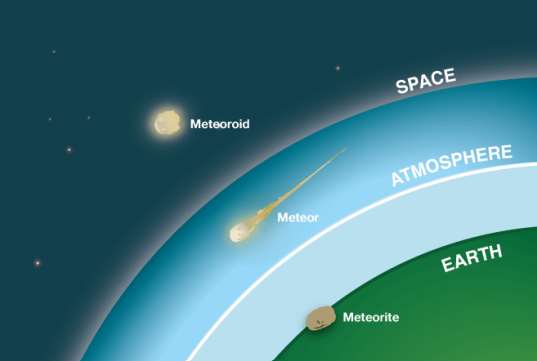
Meteoroids, Meteors, and Meteorites – The Cosmic Journey
Before understanding these, remember: all three are the same object at different stages of its journey — from space to Earth!
Meteoroids
Meteoroids are small rocky or metallic objects moving through space.
They range in size from tiny dust particles to small asteroids (few centimeters to several meters).
Origin: Mostly fragments of asteroids or comets that broke apart long ago.
Travel speed in space: up to 70 km/second (about 250,000 km/hour).
Usually found in large numbers scattered throughout the Solar System.
💡 Analogy: Think of meteoroids as 'space pebbles' — leftovers from the early Solar System floating between planets.
Meteors
When a meteoroid enters Earth’s atmosphere , it becomes a meteor .
Due to high speed and friction with air, it heats up and glows brightly — this is the ‘ shooting star ’ you see at night!
The light is caused by frictional heat as air resistance burns up the rock.
Most meteors burn completely before reaching the ground.
If the meteor is large, it may create a sonic boom (a loud explosive sound).
Extremely bright or exploding meteors are called bolides or fireballs .
💡 Fact: The average meteor is only the size of a grain of sand — yet shines brightly for a few seconds as it burns up!
Meteorites
When a meteor survives atmospheric entry and actually hits Earth’s surface, it is called a meteorite .
Meteorites are scientifically valuable because they are direct samples from space .
They help scientists understand how the Solar System formed 4.6 billion years ago .
Types of Meteorites:
Stony Meteorites: Made of silicate minerals (like rocks on Earth); most common type.
Iron Meteorites: Made mostly of iron and nickel; very heavy and dense.
Stony-Iron Meteorites: Combination of rock and metal; rare and beautiful when polished.
Famous Example: The Hoba Meteorite in Namibia — weighs about 60 tons and is the largest intact meteorite ever found on Earth.
💡 Analogy: A meteorite is like a 'visitor from space' that survived the fiery entry and landed safely on Earth.
Meteor Showers
Meteor showers occur when Earth passes through a trail of debris left by a comet .
These tiny particles (meteoroids) burn up as they enter our atmosphere, producing many meteors per hour.
Meteor showers are named after the constellation where the meteors appear to come from (called the ‘radiant point’).
Famous Meteor Showers:
Perseids: August — from Comet Swift-Tuttle; one of the brightest and most active showers.
Leonids: November — from Comet Tempel-Tuttle; known for periodic ‘meteor storms’.
Geminids: December — from asteroid 3200 Phaethon; unusual because it originates from an asteroid, not a comet.
Quadrantids: January — brief but intense meteor shower.
Peak activity occurs when Earth crosses the densest part of the debris stream .
💡 Fun Fact: During a meteor shower, you can often see 50–100 shooting stars per hour — no telescope needed!
| Term | Definition | Special Notes |
|---|---|---|
| Meteoroid | Space rock (dust grain to small asteroid) floating in space. | Originates from asteroids/comets. |
| Meteor | Meteoroid entering atmosphere; burns due to friction, appears as shooting star. | Large ones are called fireballs or bolides. |
| Meteorite | Meteor that survives atmosphere and hits Earth’s surface. | Classified as stony, iron, or stony-iron. |
Prelims tips
- Meteoroid = space rock; Meteor = shooting star in atmosphere; Meteorite = reaches Earth’s surface.
- Bolide/fireball = very bright, exploding meteor.
- Largest meteorite: Hoba (Namibia).
- Meteor showers named after constellations (Perseids, Leonids, Geminids, Quadrantids).
Mains points
- Meteors and meteorites provide natural samples of primitive Solar System material.
- Meteor showers are linked to comet debris streams and are predictable annual events.
- Meteorites are classified into stony, iron, and stony-iron types, aiding planetary science.
- Fireballs and bolides demonstrate large meteoroid impacts and possible threats to Earth.
- Study of meteors contributes to planetary defense and understanding of space hazards.
Geographical Grid, Latitude and Longitude
The geographical grid is a network of imaginary lines—latitude and longitude—used to determine exact locations on Earth. Latitudes measure north-south distance from the Equator, while longitudes measure east-west distance from the Prime Meridian.
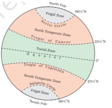
Geographical Grid
The Geographical Grid is a network of imaginary lines drawn on the Earth’s surface to locate any place precisely.
It provides exact coordinates (latitude and longitude) of any location.
This grid acts like an address system for the planet — helping us find locations just like a GPS map!
💡 Analogy: Imagine Earth as a globe covered with a grid of lines — horizontal lines (latitudes) and vertical lines (longitudes). Their intersection gives every place a unique 'address' on Earth.
Latitude
Latitude measures the distance north or south of the Equator .
They are imaginary horizontal lines that circle the globe from east to west.
Total: 180 parallels (90° North + 90° South).
Each degree of latitude is approximately 111 km apart .
Characteristics of Latitudes
Lines of latitude are parallel to each other and never meet.
The Equator (0°) is the longest latitude, dividing the Earth into the Northern Hemisphere and the Southern Hemisphere .
Latitudes help determine the climate zones (tropical, temperate, polar).
Key Latitudes and Their Significance
Equator (0°): Divides the Earth into two equal halves — Northern and Southern Hemispheres. It is a Great Circle (largest circle on Earth).
Tropic of Cancer (23.5° N): Northernmost latitude where the Sun can be directly overhead — on 21st June (Summer Solstice) .
Tropic of Capricorn (23.5° S): Southernmost latitude where the Sun can be directly overhead — on 22nd December (Winter Solstice) .
Arctic Circle (66.5° N): Marks the boundary of the area where the Sun does not set on the Summer Solstice (24 hours daylight) and does not rise on the Winter Solstice (24 hours night).
Antarctic Circle (66.5° S): Same phenomenon occurs in reverse seasons — 24 hours daylight during Southern summer and 24 hours darkness during Southern winter.
North Pole (90° N) and South Pole (90° S): The two points where all longitudes meet; represent the Earth’s axis ends.
🌍 Summary: Latitudes help us know ‘how far north or south’ a place is and determine climate zones like tropical (hot), temperate (mild), and polar (cold).
| Latitude | Position/Value | Significance |
|---|---|---|
| Equator | 0° | Divides Earth into Northern & Southern Hemispheres; Great Circle |
| Tropic of Cancer | 23.5° N | Northernmost latitude with overhead Sun (June Solstice) |
| Tropic of Capricorn | 23.5° S | Southernmost latitude with overhead Sun (December Solstice) |
| Arctic Circle | 66.5° N | Defines polar region in Northern Hemisphere |
| Antarctic Circle | 66.5° S | Defines polar region in Southern Hemisphere |
| North Pole | 90° N | Extreme northern latitude |
| South Pole | 90° S | Extreme southern latitude |
Prelims tips
- Equator is the only Great Circle; other parallels are small circles.
- Tropic of Cancer (23.5° N) and Tropic of Capricorn (23.5° S) mark solstice overhead Sun points.
- Arctic and Antarctic Circles (66.5° N/S) mark polar day/night phenomena.
- Latitude determines climate zones (Torrid, Temperate, Frigid).
Mains points
- Geographical grid forms the foundation of global navigation and cartography.
- Latitudes affect climate, vegetation, and human settlements.
- Special latitudes (Tropics and Circles) define important solar positions and climatic zones.
- Equator as a Great Circle is vital for navigation and geodesy.
- Grid system helps locate places with precision (used with longitude).
Different Motions of the Earth
The Earth has four key motions: rotation, revolution, axial tilt, and polar motion. Rotation defines day-night and Coriolis Effect, revolution defines year and seasons, tilt defines solstices/equinoxes, and polar motion reflects Earth’s dynamic axis shifts. Human activities (glacier melting, groundwater extraction) are now altering Earth’s axis.
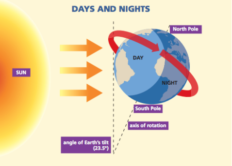
Rotation (Earth’s Spinning Motion)
Rotation is the spinning of Earth on its axis — from west to east (counterclockwise) when viewed from above the North Pole.
Duration: 23 hours 56 minutes 4 seconds (Sidereal Day); 24 hours (Solar Day).
The Circle of Illumination divides the Earth into day and night zones .
💡 Analogy: Imagine Earth as a spinning top — half lit by sunlight (day), half in shadow (night).
Significance of Rotation
Day and Night: Causes alternation of light and darkness on Earth.
Daily Weather Variation: Brings changes in temperature, air pressure, and humidity during the day.
Coriolis Effect: Earth’s rotation deflects winds and ocean currents —
→ to the right in the Northern Hemisphere ,
→ to the left in the Southern Hemisphere .
Helps in forming trade winds, jet streams, and cyclones .
Drives ocean currents such as the Gulf Stream (Atlantic) and Kuroshio Current (Pacific).
Affects tides when combined with the gravitational pull of the Moon and the Sun.
🌍 Fact: The Earth’s rotation speed at the Equator is about 1,670 km/h !
Revolution (Earth’s Orbit Around the Sun)
Revolution means the movement of Earth around the Sun in an elliptical (oval) orbit .
Duration: 365 days 6 hours 9 minutes = 1 year.
The extra 6 hours accumulate, leading to a leap year (366 days) every 4 years.
💡 Analogy: Earth’s revolution is like a runner moving around a circular track while spinning on its own axis.
Significance of Revolution
Formation of Seasons: Caused by Earth’s axial tilt (23.5°) and its orbit around the Sun.
Variation in Day & Night Length: Different regions receive different sunlight throughout the year.
Equinoxes (Equal Day & Night):
- 21st March: Vernal (Spring) Equinox.
- 23rd September: Autumnal Equinox.
Solstices (Unequal Day & Night):
- 21st June: Longest day (Summer Solstice, Northern Hemisphere).
- 22nd December: Longest night (Winter Solstice, Northern Hemisphere).
Aphelion: Earth farthest from the Sun — 4 July (~152 million km) .
Perihelion: Earth closest to the Sun — 3 January (~147 million km) .
🌞 Fact: Even though Earth is closest to the Sun in January, it’s winter in the Northern Hemisphere because of the tilt — not distance!
Axis of the Earth
The axis is an imaginary line passing from the North Pole to the South Pole through Earth’s center.
It is tilted at 23.5° from the vertical (or 66.5° with respect to the plane of Earth’s orbit, called the ecliptic ).
The tilt causes unequal solar heating at different latitudes — leading to seasons.
If there were no tilt, every place on Earth would have equal day and night all year — no seasons!
The tilt is vital for agriculture, monsoon patterns, and climate distribution .
🌎 Fact: The axis always points toward the same direction in space — toward the North Star (Polaris) .
Polar Motion (Shift in Earth’s Axis)
Polar Motion means slight movement of Earth’s rotational axis relative to its crust.
Caused by redistribution of Earth’s mass — due to melting glaciers, ocean circulation, or atmospheric pressure shifts .
Has two types:
- Seasonal Motion: Small cyclic changes.
- Long-term Drift: Gradual shift over decades.
Recent Axis Shifts
Global Warming: Melting glaciers have redistributed massive amounts of water toward the oceans.
Groundwater Depletion: Excessive extraction in India, China, and the USA has shifted Earth's mass.
Since the 1990s, Earth’s pole has been drifting eastward at about 4 cm per year.
NASA Study (2021): Found that groundwater loss is a major cause behind the measurable shift of Earth’s spin axis.
🧭 Summary: Earth spins (rotation) → gives day & night; moves around the Sun (revolution) → gives seasons; tilted axis → makes seasons possible and diverse!
| Motion | Duration | Key Effects |
|---|---|---|
| Rotation | 23h 56m 4s (sidereal) | Day-night cycle, Coriolis Effect, winds, currents, tides. |
| Revolution | 365d 6h 9m | Seasons, solstices, equinoxes, Aphelion (July 4), Perihelion (Jan 3). |
| Axis Tilt | 23.5° | Seasonal variation, climatic zones, length of day-night. |
| Polar Motion | Variable | Axis drift due to ice melt, groundwater depletion, atmospheric changes. |
Prelims tips
- Sidereal day = 23h 56m; Solar day = 24h.
- Leap year rule: years divisible by 4, except centuries not divisible by 400.
- Seasons caused by axial tilt, not distance from Sun.
- Aphelion = July 4, Perihelion = Jan 3.
- Coriolis Effect → cyclones rotate anticlockwise in NH, clockwise in SH.
- Polar motion accelerated after 1990 due to glacier melt & groundwater depletion.
Mains points
- Rotation influences atmospheric/oceanic circulation → key to global climate.
- Revolution and axial tilt determine agricultural calendars, monsoon onset, energy balance.
- Equinoxes and solstices regulate festivals, cultural events, and agricultural practices worldwide.
- Aphelion & Perihelion show Earth-Sun distance variation but climate depends more on tilt.
- Polar motion reflects Earth’s dynamic nature and shows anthropogenic impact on geophysical systems.
- Axis tilt and its constancy crucial for life; even small changes can alter habitability.
Seasons
Earth experiences four major seasons—Summer, Winter, Spring, and Autumn—caused by its revolution around the Sun and axial tilt (23.5°). While one hemisphere has summer, the other has winter. Solstices and equinoxes mark the transition points. Polar regions experience continuous day or night for six months. Seasonal cycles are also linked with agriculture, monsoon, and cultural traditions.
Scientific Basis of Seasons
Why seasons happen: Seasons occur because Earth’s axis is tilted 23.5° relative to the plane of its orbit. As Earth revolves around the Sun, different parts of the Earth receive different amounts of sunlight.
Thermal equator: The place on Earth that receives the most direct sunlight shifts north and south through the year — this is why temperatures change with seasons.
Simple idea: When your hemisphere tilts toward the Sun you get more direct sunlight and warmer weather (summer). When it tilts away you get less direct sunlight and cooler weather (winter).
If Earth had no tilt: Every place would receive roughly the same sunlight year-round → no seasons .
💡 Analogy: Think of a tilted lamp shining on a globe while you walk the globe around it. Sometimes the lamp lights the top more, sometimes the bottom — that change is what makes seasons.
Solstices and Equinoxes (Important Dates)
Summer Solstice (≈ 21 June): Longest day in the Northern Hemisphere. Sun is directly overhead at the Tropic of Cancer (23.5° N).
Winter Solstice (≈ 22 December): Shortest day (longest night) in the Northern Hemisphere. Sun is directly overhead at the Tropic of Capricorn (23.5° S).
Vernal (Spring) Equinox (≈ 21 March): Day and night are about equal; Sun is overhead at the Equator . Marks start of spring in the Northern Hemisphere.
Autumnal (Fall) Equinox (≈ 23 September): Day and night about equal; start of autumn in the Northern Hemisphere.
Special Polar Phenomena
Midnight Sun: Above the Arctic Circle (and below the Antarctic Circle in their summer) the Sun can stay above the horizon for 24 hours — continuous daylight.
Polar Night: Opposite season — continuous night for weeks or months in polar regions.
Where Sun can be overhead at noon: Only places between the Tropic of Cancer and the Tropic of Capricorn can have the Sun directly overhead at local noon (once or twice a year).
Seasons by Months — What Usually Happens
June – August
Northern Hemisphere: Sun’s rays are more direct → Summer (hot). Arctic regions may have continuous daylight.
Southern Hemisphere: Sun’s rays slant more → Winter (cold). Antarctic regions may have continuous night.
December – February
Northern Hemisphere: Sun’s rays slant → Winter (cold). Arctic has long nights.
Southern Hemisphere: Direct rays → Summer (hot). Antarctic has long daylight.
September – November
Northern Hemisphere: Autumn (Fall) . Temperatures cool; leaves change color in many regions.
Southern Hemisphere: Spring . Plants begin to grow.
March – May
Northern Hemisphere: Spring . Warming weather, plants bloom.
Southern Hemisphere: Autumn . Cooling weather.
Indian Context — Practical Notes
Uttarayan: Sun’s apparent northward movement — considered to begin after 14 January (Makar Sankranti) in Indian tradition (astronomical date slightly different).
Dakshinayan: Sun’s apparent southward movement around 21 June .
Agriculture: Indian cropping seasons are tied to these cycles — Kharif crops (monsoon/summer) and Rabi crops (winter).
Festivals: Many Indian festivals align with seasons — e.g., Holi (spring), Diwali (autumn harvest), Pongal/Makar Sankranti (Sun’s transition).
Climate Change — How It Affects Seasons
Monsoon shifts: Timing and intensity of monsoon rains in South Asia are becoming less predictable.
Longer summers / shorter winters: Many mid-latitude regions are experiencing longer warm seasons and shorter cold seasons.
Polar ice melt: Reduces Earth’s reflectivity (albedo), which changes how heat is absorbed — affects seasonal energy balance.
More extreme events: Disturbed seasonal patterns lead to heatwaves, intense storms, unseasonal rainfall and droughts.
🔎 Quick recap: Seasons = tilt of Earth’s axis + Earth’s revolution . Tilt decides which hemisphere gets more direct sunlight at any time — that creates the cycle of seasons.
| Months | Northern Hemisphere | Southern Hemisphere | Special Phenomena |
|---|---|---|---|
| June - August | Summer; long days; Midnight Sun in Arctic | Winter; long nights; Polar Night in Antarctic | Sun overhead Tropic of Cancer (21 June) |
| December - February | Winter; long nights | Summer; long days | Sun overhead Tropic of Capricorn (22 Dec) |
| March - May | Spring | Autumn | Equinox: Sun overhead Equator (21 March) |
| September - November | Autumn | Spring | Equinox: Sun overhead Equator (23 September) |
Prelims tips
- Seasons result from Earth’s axial tilt (23.5°), not distance from Sun.
- Solstices: 21 June (longest day in North), 22 December (longest night in North).
- Equinoxes: 21 March, 23 September → equal day-night worldwide.
- Midnight Sun occurs in Arctic Circle in June-July.
- Uttarayan & Dakshinayan linked to Indian calendar and festivals.
- Polar regions have 6 months continuous day/night.
Mains points
- Seasons regulate agriculture, biodiversity, and water cycles.
- Solstices and equinoxes shape cultural calendars and global festivals.
- Polar regions’ seasonal extremes influence global climate patterns.
- Indian agriculture depends heavily on monsoonal seasonality (Kharif, Rabi).
- Climate change is altering seasonal cycles, leading to irregular rainfall and longer summers.
- Seasonal transitions affect migration patterns of birds, animals, and human settlements historically.
Solstices and Equinoxes
Solstices and equinoxes mark the key turning points in Earth’s revolution. Solstices (21 June and 22 December) are the longest and shortest days of the year, while equinoxes (21 March and 23 September) have equal day and night worldwide.
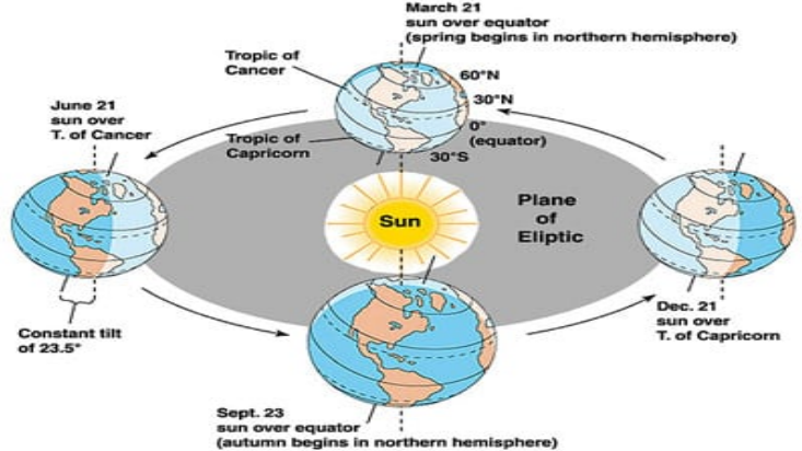
Summer Solstice (≈ 21 June)
The Sun is directly overhead at the Tropic of Cancer (23.5° N) .
Northern Hemisphere:
- Longest day and shortest night of the year.
- Marks the official start of Summer .
- Areas within the Arctic Circle experience 24-hour daylight (known as the Midnight Sun ).
Southern Hemisphere:
- Shortest day and longest night.
- Start of Winter season.
💡 Reason: The Northern Hemisphere tilts most toward the Sun, receiving maximum direct sunlight.
Winter Solstice (≈ 22 December)
The Sun is directly overhead at the Tropic of Capricorn (23.5° S) .
Southern Hemisphere:
- Longest day and shortest night.
- Start of Summer season.
- Antarctic Circle: 24-hour daylight.
Northern Hemisphere:
- Shortest day and longest night.
- Start of Winter season.
💡 Reason: The Southern Hemisphere tilts most toward the Sun, receiving maximum sunlight.
Equinoxes (≈ 21 March & 23 September)
The Sun is directly overhead at the Equator .
Day and night are equal in length all over the world.
21 March — Vernal (Spring) Equinox:
- Northern Hemisphere → Spring begins .
- Southern Hemisphere → Autumn begins .
23 September — Autumnal Equinox:
- Northern Hemisphere → Autumn begins .
- Southern Hemisphere → Spring begins .
💡 Reason: Earth’s axis is neither tilted toward nor away from the Sun — sunlight falls equally on both hemispheres.
🌎 Quick Recap:
June Solstice: Longest day in North, shortest in South.
December Solstice: Longest day in South, shortest in North.
Equinoxes: Equal day and night everywhere — a balance point in the year.
| Event | Date | Sun Position | Northern Hemisphere | Southern Hemisphere |
|---|---|---|---|---|
| Summer Solstice | 21 June | Over Tropic of Cancer | Longest day, shortest night | Shortest day, longest night |
| Winter Solstice | 22 December | Over Tropic of Capricorn | Shortest day, longest night | Longest day, shortest night |
| Spring Equinox | 21 March | Over Equator | Equal day & night; Spring begins | Equal day & night; Autumn begins |
| Autumn Equinox | 23 September | Over Equator | Equal day & night; Autumn begins | Equal day & night; Spring begins |
Prelims tips
- Summer Solstice: 21 June → NH: longest day; SH: shortest day.
- Winter Solstice: 22 Dec → NH: shortest day; SH: longest day.
- Equinoxes: Equal day-night worldwide (21 March, 23 September).
- Midnight Sun: Arctic Circle in June, Antarctic Circle in December.
- Sun is never overhead beyond Tropics (23.5° N to 23.5° S).
Mains points
- Solstices and equinoxes are key astronomical events shaping seasonal changes.
- They influence agricultural calendars, festivals, and cultural traditions worldwide.
- Solstices regulate polar phenomena like Midnight Sun and Polar Night.
- Equinoxes mark equal day-night and are vital for navigation and calendars.
- Understanding solstices and equinoxes helps in climate studies and monsoon prediction.
Atmosphere and Evolution of Earth’s Atmosphere
The atmosphere is the envelope of gases surrounding the Earth, essential for life. It evolved in stages—from a primordial hydrogen-helium atmosphere, to a volcanic degassing atmosphere, to the oxygen-rich atmosphere we have today due to photosynthesis.
Atmosphere: General Features
The atmosphere is a layer of gases surrounding the Earth , held in place by gravity.
It extends up to about 10,000 km , but 99% of its total mass lies within 30 km from Earth’s surface.
It contains gases essential for life, weather, and climate .
Functions of the Atmosphere
Protects life: Blocks harmful ultraviolet (UV) rays from the Sun.
Controls temperature: Keeps Earth warm (like a blanket) — prevents extreme heat in the day and cold at night.
Enables weather: Winds, clouds, and rain form in the atmosphere.
Supports life: Provides oxygen for breathing and carbon dioxide for photosynthesis.
💡 Analogy: Think of the atmosphere as Earth’s protective “skin” — without it, the planet would be lifeless like the Moon or Mercury.
Evolution of the Atmosphere
The atmosphere has evolved over 4.6 billion years through different stages.
Stage I – Primordial Atmosphere
Formed soon after Earth’s origin (~4.6 billion years ago).
Dominated by hydrogen and helium — light gases similar to those found in the Sun and Jupiter.
Lost quickly due to strong solar winds and weak gravity of young Earth.
🌫️ Result: Earth temporarily lost its gaseous envelope.
Stage II – Secondary Atmosphere (Volcanic Degassing)
Developed through volcanic outgassing — gases released from inside Earth.
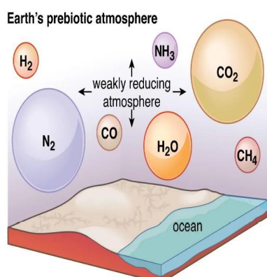
Main gases: Water vapor (H₂O), Carbon dioxide (CO₂), Methane (CH₄), Ammonia (NH₃), Nitrogen (N₂) .
This atmosphere was dense and reducing (lacking free oxygen).
Over time, water vapor condensed and caused heavy rains — forming the first oceans (~4 billion years ago).
💧 Result: Oceans began to trap CO₂, cooling the planet and setting the stage for life.
Stage III – Oxygenation (The Great Oxidation Event)
Around 2.5 billion years ago , tiny microorganisms called cyanobacteria (blue-green algae) started photosynthesis .
They released oxygen (O₂) as a byproduct into the atmosphere.
Oxygen combined with iron in oceans → forming banded iron formations (visible in rocks today).
Gradually, oxygen levels increased, leading to the formation of the ozone (O₃) layer around 600 million years ago .
The ozone layer shielded life from UV rays, allowing organisms to survive on land.
🌿 Result: The rise of oxygen transformed Earth’s environment — making complex life possible.
Stage IV – Modern Atmosphere
The atmosphere reached its current balance over time through biogeochemical cycles (carbon, nitrogen, oxygen cycles).
Present composition:
- Nitrogen (N₂): ~78% — inert gas that dilutes oxygen and stabilizes reactions.
- Oxygen (O₂): ~21% — essential for respiration and burning.
- Argon (Ar): ~0.93% — inert noble gas.
- Carbon dioxide (CO₂): ~0.04% — traps heat, key for photosynthesis.
- Other gases: Neon, helium, methane, ozone, water vapor (in variable amounts).
Modern balance is maintained naturally, but human activities are disturbing it — e.g., rising CO₂, global warming , and ozone depletion .
🌎 Summary: Earth’s atmosphere evolved from a toxic, lifeless gas cloud to a balanced, life-supporting system — and humans now play a major role in changing it.
| Stage | Time Period | Main Features | Composition |
|---|---|---|---|
| Primordial | ~4.6 bya | Formed from solar nebula, lost due to solar wind | Hydrogen, Helium |
| Secondary (Volcanic) | ~4.0 bya | Formed by volcanic outgassing | CO2, H2O vapor, NH3, CH4, N2 |
| Great Oxidation Event | ~2.5 bya | Photosynthesis by cyanobacteria | O2 released, iron oxide layers formed |
| Modern | ~600 mya – present | Stable, supports complex life | 78% N2, 21% O2, traces of Ar, CO2 |
Prelims tips
- Primordial atmosphere lost due to solar winds.
- Secondary atmosphere formed mainly by volcanic outgassing.
- Great Oxidation Event (~2.5 bya) introduced free oxygen.
- Modern atmosphere: 78% N2, 21% O2.
- Ozone layer formed ~600 mya, enabling life on land.
Mains points
- Atmospheric evolution shows Earth’s transition from a lifeless planet to a habitable one.
- Oxygenation shaped biodiversity and enabled complex multicellular life.
- Volcanic degassing linked to ocean and atmosphere formation.
- Human-induced changes (CO2, methane, aerosols) are altering atmospheric balance.
- Understanding atmospheric evolution helps in studying exoplanets and astrobiology.
Composition of the Earth’s Atmosphere
The Earth's atmosphere is a mixture of gases, water vapor, dust, and aerosols. It is dominated by nitrogen and oxygen, with small amounts of argon, carbon dioxide, ozone, water vapor, and trace gases that play critical roles in climate and life processes.
Major Components of the Atmosphere
The atmosphere is made up of a mixture of gases . Although many gases exist, only a few dominate the total composition.
Permanent Gases (Make up ~99.9% of total volume)
Nitrogen (N₂) – 78.08%
- Most abundant gas in the atmosphere.
- Role: Maintains air stability and prevents excessive burning by diluting oxygen.
- Part of the nitrogen cycle , essential for soil fertility and plant growth.
Oxygen (O₂) – 20.95%
- Vital for respiration (animals) and photosynthesis (plants).
- Supports combustion (burning).
- Helps in formation of ozone (O₃) in the stratosphere.
Argon (Ar) – 0.93%
- A noble gas ; chemically inactive (inert).
- Adds stability to the air composition.
Carbon Dioxide (CO₂) – ~0.04% (variable)
- A greenhouse gas — traps heat and keeps Earth warm.
- Used by plants in photosynthesis to make food.
- Controls climate and temperature balance on Earth.
- Amount fluctuates due to respiration, volcanism, deforestation, and industrial emissions.
Ozone (O₃) – Trace amount
- Found mainly in the stratosphere (as ozone layer).
- Absorbs harmful ultraviolet (UV) rays from the Sun.
- Protects living organisms from radiation damage.
Water Vapor (H₂O) – 0–4% (variable)
- Found mostly in the lower atmosphere .
- Controls humidity , weather patterns , and rainfall .
- Acts as a strong greenhouse gas — absorbs and stores heat.
Other Trace Gases: Neon, Helium, Krypton, Xenon, Methane (CH₄), Nitrous Oxide (N₂O), Hydrogen, etc.
- Though present in small amounts, they are important for climate regulation and chemical balance .
Variable Constituents of the Atmosphere
These components change with time and place .
Dust and Aerosols: Tiny particles from soil, sea salt, pollen, volcanoes, industries, etc. They act as condensation nuclei — help clouds and raindrops form.
Water Vapor: Changes daily with temperature and weather; influences humidity, rainfall, and storms .
Carbon Dioxide (CO₂) and Methane (CH₄): Key greenhouse gases that trap heat and cause global warming .
Importance of Atmospheric Composition
Balance of Nitrogen and Oxygen: Supports life and maintains chemical stability.
Trace gases: Such as CO₂ and O₃ regulate global temperature and protect from harmful UV rays.
Water vapor and dust: Govern rainfall, cloud formation, and weather systems.
🌍 Summary: A delicate balance between major and minor gases keeps Earth habitable — even small changes in CO₂ or H₂O can affect global climate and life systems.
| Gas | Percentage by Volume | Role |
|---|---|---|
| Nitrogen (N₂) | 78.08% | Dilutes O₂, part of nitrogen cycle |
| Oxygen (O₂) | 20.95% | Respiration, combustion, ozone formation |
| Argon (Ar) | 0.93% | Inert, provides stability |
| Carbon Dioxide (CO₂) | 0.04% (variable) | Photosynthesis, greenhouse effect |
| Neon, Helium, Krypton, Xenon | Trace | Inert gases, minor roles |
| Ozone (O₃) | Trace | UV radiation shield |
| Methane (CH₄) | Trace (~1.9 ppm) | Greenhouse gas |
| Nitrous Oxide (N₂O) | Trace (~0.3 ppm) | Greenhouse gas |
| Water Vapor (H₂O) | 0–4% | Weather, rainfall, climate |
Prelims tips
- Nitrogen: 78%, Oxygen: 21%, Argon: 0.93%, CO₂: 0.04%.
- Water vapor varies (0–4%), controls weather and rainfall.
- Ozone is a trace gas but critical for UV protection.
- Methane and N₂O are powerful greenhouse gases.
- 99% of atmosphere is within 30 km of Earth.
Mains points
- Atmosphere is dominated by N₂ and O₂, ensuring life processes.
- Trace gases, though small in volume, regulate global climate (CO₂, CH₄, O₃).
- Water vapor is highly variable but critical for weather and rainfall.
- Human activities are increasing greenhouse gases, altering natural composition.
- Composition study helps in understanding climate change, global warming, and pollution impacts.
Variable Gases of the Atmosphere
Variable gases like water vapor, carbon dioxide, and ozone are present in small but fluctuating amounts. They are critical in controlling weather, climate, and life-supporting processes, unlike constant gases such as nitrogen and oxygen.
Water Vapor (H₂O)
Water vapor is the gaseous form of water present in the air. It is one of the most important variable components of the atmosphere.
Concentration and Distribution
Amount varies from 0% to 4% by volume depending on temperature, location, and altitude.
Found mainly in the lower atmosphere (Troposphere) , where evaporation and condensation take place.
Warm regions (like the tropics) have more water vapor; cold regions (like the poles) have very little.
Sources of Water Vapor
Evaporation: Water from oceans, rivers, and lakes turns into vapor due to heat from the Sun.
Transpiration: Plants release moisture through tiny pores in their leaves.
Sublimation: Ice or snow directly turns into vapor in polar regions.
Role and Importance
Weather Formation: Water vapor condenses into clouds and leads to rainfall, snowfall, fog, and storms .
Greenhouse Effect: Water vapor traps heat in the atmosphere, keeping Earth’s average temperature around 15°C. Without it, Earth would be frozen.
Transport of Heat: When vapor changes to liquid, it releases latent heat (hidden heat), which helps drive winds and storms.
Hydrological Cycle: Part of the continuous cycle of evaporation → condensation → precipitation → runoff .
Humidity: The amount of water vapor determines humidity, affecting comfort, weather, and climate.
💡 Example: After rain, the air feels sticky and heavy because humidity (water vapor) increases, slowing down evaporation from your skin.
Environmental Role
Acts as a natural greenhouse gas that keeps the planet warm.
But excessive moisture increases the intensity of storms, cyclones, and heavy rainfall events due to more latent heat release.
Carbon Dioxide (CO₂)
Carbon dioxide is a colorless, odorless gas that plays a vital role in maintaining the planet’s heat balance and supporting life.
Concentration
Present in the atmosphere at about 0.04% (400 parts per million).
This concentration is increasing steadily because of human activities like burning coal, oil, and cutting trees.
Sources of Carbon Dioxide
Natural: Respiration by animals and plants, volcanic eruptions, decomposition of organic matter, forest fires.
Human-made: Burning of fossil fuels, deforestation, cement production, industrial emissions, and vehicles.
Role and Importance
Greenhouse Gas: Traps heat in the atmosphere, preventing Earth from becoming too cold.
Photosynthesis: Plants absorb CO₂ and release oxygen. It’s the basis of all food chains.
Temperature Regulation: A natural balance of CO₂ keeps the climate stable. Too much leads to global warming .
Carbon Cycle: CO₂ continuously circulates between air, land, water, and living organisms through processes like respiration, photosynthesis, and decomposition.
Seasonal Variation
CO₂ levels fall in summer (more plant growth absorbs it).
Levels rise in winter (plants shed leaves, less absorption).
Environmental Concerns
Rising CO₂ → enhanced greenhouse effect → higher global temperatures.
Leads to melting ice caps , rising sea levels , heat waves , and unpredictable rainfall patterns .
Modern CO₂ rise is mainly due to industrialization after 1850 (Industrial Revolution).
💡 Example: Venus has a thick CO₂ atmosphere that traps heat — its surface is hot enough to melt lead!
Ozone (O₃)
Ozone is a molecule made of three oxygen atoms . It is a trace gas but extremely important for life on Earth.
Distribution of Ozone
Stratosphere (20–30 km above Earth): Contains the Ozone Layer , which protects Earth from harmful ultraviolet (UV) rays.
Troposphere (near the surface): Contains small amounts of “ bad ozone ” formed by pollution (vehicles, industries).
Role and Importance
UV Protection: The ozone layer absorbs about 97–99% of UV-B and UV-C rays, preventing skin cancer and crop damage.
Temperature Regulation: Ozone absorbs UV radiation, warming the stratosphere and maintaining atmospheric layering.
Air Quality: In the lower atmosphere, ozone acts as a pollutant and is a major component of photochemical smog (formed when sunlight reacts with vehicle fumes).
Ozone Depletion
Cause: Chemicals like CFCs (Chlorofluorocarbons) , Halons , and Freons break down ozone molecules.
Ozone Hole: A region of extremely thin ozone, first detected over Antarctica in the 1980s.
Effects: Increased UV exposure causes skin diseases, eye damage, and reduces plankton growth in oceans.
Global Response: The Montreal Protocol (1987) was signed by 197 countries to stop the use of CFCs — one of the most successful environmental agreements.
💡 Example: The ozone layer acts like Earth’s sunscreen — without it, humans and animals would suffer from intense solar radiation.
Summary
Water Vapor: Controls humidity, rainfall, and heat balance — a natural greenhouse gas.
Carbon Dioxide: Essential for plant life but excess causes global warming.
Ozone: Shields Earth from UV rays but is threatened by pollution.
🌍 Together, these three gases maintain Earth’s temperature, weather, and life-supporting balance . Even small changes in their proportions can affect the entire climate system.
| Gas | Concentration | Role |
|---|---|---|
| Water Vapor (H₂O) | 0–4% | Weather, rainfall, greenhouse effect, latent heat transport |
| Carbon Dioxide (CO₂) | 0.04% (increasing) | Photosynthesis, greenhouse effect, climate regulator |
| Ozone (O₃) | Trace | UV protection (stratosphere), air pollutant (troposphere) |
Prelims tips
- Water vapor varies most (0–4%), key in weather and rainfall.
- CO₂ ~0.04% but rising due to human activity → global warming.
- Ozone: good in stratosphere (UV shield), bad in troposphere (pollutant).
- Ozone hole first observed over Antarctica in 1985.
- Variable gases are critical despite small percentage.
Mains points
- Variable gases play disproportionate roles in Earth’s energy balance.
- Water vapor: strongest greenhouse gas, weather controller.
- CO₂: rising levels link to anthropogenic climate change.
- Ozone: stratospheric shield but tropospheric pollutant.
- Studying variable gases is key for climate models and environmental policy.
Atmospheric Temperature – Processes of Heating and Cooling
The Earth's atmosphere gets heated and cooled by four main processes – Radiation, Conduction, Convection, and Advection. These processes regulate temperature distribution, weather phenomena, and energy balance of the planet.
Heat Transfer in the Atmosphere — An Easy Overview
Heat energy moves around Earth mainly by four methods: Radiation, Conduction, Convection, and Advection . Each plays a unique role in heating the atmosphere and controlling weather and climate.
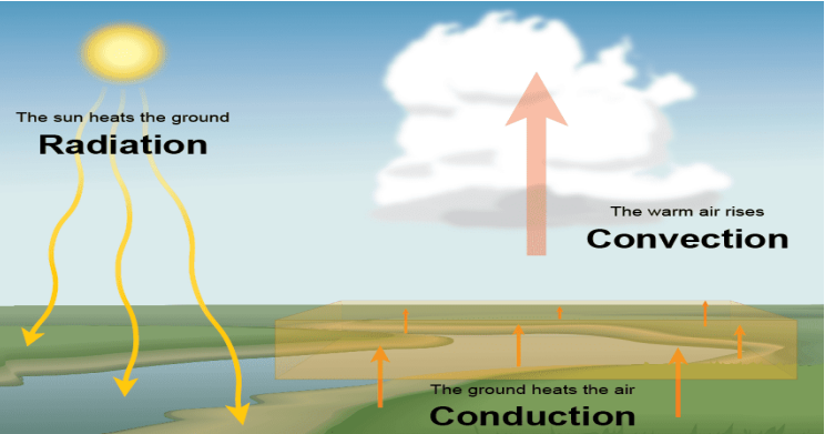
1. Radiation
Definition: Transfer of heat through electromagnetic waves — it does not need any medium (can occur in a vacuum).
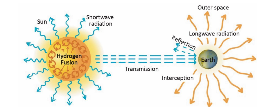
Types of radiation: Shortwave (visible and UV rays from Sun) and Longwave (infrared rays emitted by Earth).
How it works: The Sun emits radiation in all directions; the Earth absorbs some of it and reflects the rest. The absorbed heat is later emitted as longwave infrared radiation back toward space.
Speed: Very fast — travels at the speed of light.
Example: Sunlight warming the ground during daytime or solar panels absorbing sunlight to generate electricity.
Fun fact: The warmth you feel near a fire without touching it — that’s also radiation!
Why Radiation Matters:
It is the primary source of Earth’s energy — drives weather, climate, and photosynthesis.
The balance between incoming solar radiation and outgoing terrestrial radiation maintains Earth’s average temperature (~15°C).
Imbalance causes global warming (too much trapped heat) or cooling (too much reflected heat).
2. Conduction
Definition: Transfer of heat through direct contact between molecules.
Medium: Requires a solid or dense material; heat passes from molecule to molecule.
Process: When Earth’s surface is heated by the Sun, it warms the layer of air in direct contact with it through conduction.
Speed: Slow, since it depends on molecular collisions.
Example: A metal rod getting hot at one end when the other end is placed in fire; the air near the ground warming up during daytime.
Why Conduction Matters:
Although limited to the thin air layer near the ground, it’s the starting point for heating the atmosphere . Once this air gets warm, it rises and sets off convection currents.
Plays a role in surface heating during calm, sunny days.
3. Convection
Definition: Transfer of heat within fluids (liquids and gases) by actual movement of the particles.
Medium: Requires air or water — movement occurs in vertical direction.
How it works: Warm air expands, becomes lighter, and rises; cooler air sinks to replace it — creating a vertical circulation pattern called a convection cell .
Example: Rising of warm air forming clouds; boiling water in a pot (hot water rises, cool water sinks).
Convection in the Atmosphere:
Responsible for cloud formation , thunderstorms , and vertical mixing of air .
Creates updrafts and downdrafts that drive local weather systems.
Convection currents near the equator form Hadley Cells , influencing trade winds and tropical rainfall.
Beginner Analogy: Convection is like boiling water — the bubbles are rising warm air currents in our atmosphere!
4. Advection
Definition: Horizontal transfer of heat through moving air masses (winds).
Medium: Air (horizontal motion).
Example: Warm winds from oceans make coastal areas milder in winter; cold winds from polar regions bring sudden temperature drops.
In oceans: Similar horizontal heat movement happens via ocean currents (e.g., Gulf Stream brings warm water to Europe).
Why Advection Matters:
Plays a major role in global temperature redistribution — prevents extreme heat or cold buildup in one place.
Important for monsoon formation , sea breezes , and fronts (boundaries between warm and cold air masses).
How These Processes Work Together
Step 1: Sun radiates energy (radiation).
Step 2: Earth’s surface absorbs and conducts heat to the air in contact (conduction).
Step 3: Warm air rises and circulates vertically (convection).
Step 4: Winds and ocean currents move heat horizontally (advection).
This continuous cycle keeps the atmosphere in motion — balancing temperature and driving weather patterns.
Key Takeaway for Beginners:
Radiation → Heat without contact (Sun to Earth).
Conduction → Heat by contact (ground to air).
Convection → Heat by rising and sinking air (vertical).
Advection → Heat by moving winds (horizontal).
Together they form Earth’s natural heating and weather engine!
| Process | Medium Required | Direction | Rate of Transfer | Example |
|---|---|---|---|---|
| Radiation | No medium | Any (wave propagation) | Fast | Solar radiation reaching Earth |
| Conduction | Yes (solids) | Direct contact | Slow | Surface heating adjacent air |
| Convection | Yes (fluids) | Vertical | Slow–moderate | Warm air rising, clouds forming |
| Advection | Yes (fluids) | Horizontal | Slow–moderate | Winds transferring heat across regions |
Prelims tips
- Radiation: only process that does not need a medium (occurs in vacuum).
- Conduction: important at Earth’s surface–air interface.
- Convection: responsible for clouds, thunderstorms, vertical mixing.
- Advection: responsible for horizontal heat transfer (e.g., warm/cold winds).
- Circle of illumination = division between day and night due to rotation + radiation.
Mains points
- Heating and cooling of atmosphere occur via four processes: radiation, conduction, convection, and advection.
- Radiation is the fastest and works in vacuum; others need a medium.
- Conduction is limited to surface–air interaction, less significant in free atmosphere.
- Convection drives vertical circulation, clouds, and precipitation.
- Advection redistributes heat horizontally, influencing regional climates.
- Understanding these processes is crucial for weather forecasting and climate studies.
Insolation
Insolation is the solar energy received by the Earth. Although the Sun emits enormous energy, only a tiny fraction reaches the Earth due to its small size and great distance. Insolation varies with latitude, season, cloud cover, and topography.
What is Insolation?
Insolation stands for incoming solar radiation — the total solar energy received by Earth from the Sun.
It is measured in Langleys (Ly) or Watts per square meter (W/m²) .
At the top of Earth’s atmosphere, the average incoming solar radiation is about 1.94 calories/cm²/min or roughly 1361 W/m² — this is known as the solar constant .
However, only a tiny fraction (about one in two billion parts) of the Sun’s total output reaches Earth.
Insolation drives weather, climate, photosynthesis, and temperature variations across the globe.
Easy Analogy for Beginners:
Think of the Sun like a giant lamp — Earth receives only a small part of its light and heat, depending on how directly the lamp shines on each part of the planet.
Factors Affecting Insolation
1. Angle of Incidence (Angle of the Sun’s Rays)
The angle at which sunlight strikes the surface affects how concentrated or spread out the energy is.
Direct rays (near the equator) deliver more energy per unit area — that’s why it’s warmer there.
Oblique rays (toward the poles) spread the same energy over a larger area — resulting in cooler temperatures.
The Sun appears higher in the sky at noon near the equator but lower near the poles.
➡️ Key Point: The smaller the shadow you cast, the higher the insolation you’re getting!
2. Duration of Day (Length of Daylight)
Longer days allow more time for the Sun to heat the surface — hence more insolation.
Summer: Long days → more energy received → higher temperatures.
Winter: Short days → less time for heating → lower temperatures.
The difference in daylight duration between summer and winter is greater in higher latitudes.
➡️ Example: Near the poles, the Sun doesn’t set in summer (24-hour daylight), while in winter it may not rise at all — leading to extreme temperature contrast.
3. Transparency of the Atmosphere
Earth’s atmosphere is mostly transparent to shortwave solar radiation (sunlight), but not all of it reaches the surface.
Factors affecting transparency include:
– Cloud cover: Thick clouds reflect and absorb sunlight, reducing insolation.
– Dust and pollutants: Scatter sunlight and block it from reaching the ground.
– Water vapor: Absorbs some sunlight, reducing the heat that reaches the surface.
Clear sky = higher insolation; cloudy/polluted sky = lower insolation.
➡️ Example: After a volcanic eruption, global temperatures can drop because volcanic ash blocks sunlight.
4. Topography (Relief and Surface Features)
The shape and orientation of land affect how much sunlight it receives.
Altitude: Higher areas get more direct sunlight but thinner air reduces the heat retained — so high mountains are cooler despite strong sunlight.
Aspect (slope direction): In the Northern Hemisphere, south-facing slopes get more sunlight (warmer and drier); north-facing slopes get less (cooler and moister). The opposite happens in the Southern Hemisphere.
Valleys and shaded areas receive less sunlight because of obstruction by surrounding terrain.
➡️ Example: Vineyards are often on south-facing slopes because they receive more sunlight for ripening grapes.
Additional Factors (For Better Understanding)
5. Latitude
Insolation is maximum at the equator and decreases toward the poles.
The equator gets more direct sunlight year-round , while the poles receive slanted rays.
6. Time of Year (Seasonal Changes)
Due to Earth’s axial tilt (23.5°) , the Sun’s apparent position changes throughout the year.
During solstices, one hemisphere tilts toward the Sun (receives more insolation), while the other tilts away (receives less).
7. Earth’s Rotation and Revolution
The daily rotation causes day-night variation in insolation.
The annual revolution causes seasonal changes in the amount and duration of sunlight.
How Insolation Affects Climate
Temperature patterns: Areas with more insolation are warmer (tropics) while those with less are colder (poles).
Pressure and winds: Unequal heating creates pressure differences that drive winds.
Ocean currents: Insolation differences affect sea temperature, influencing marine currents.
Vegetation and rainfall: More solar energy promotes evaporation and rainfall in tropical regions.
➡️ Bottom Line for Beginners:
Insolation is the main energy source for all weather and life on Earth. How much sunlight a place gets depends on its latitude, time of year, and atmospheric conditions — these factors together shape the world’s diverse climates.
| Factor | Effect on Insolation | Example |
|---|---|---|
| Angle of Incidence | Direct rays = more; oblique rays = less | Equator vs Poles |
| Duration of Day | Longer day = more insolation | Summer vs Winter |
| Atmospheric Transparency | Clouds, dust reduce insolation; clear sky increases | Monsoon vs Desert sky |
| Topography | Slope orientation & altitude affect insolation | South-facing slopes warmer in NH |
Prelims tips
- Insolation measured in Langleys (Ly).
- Average = ~2 Langley per sq. cm per min at top of atmosphere.
- Angle of incidence is most important factor.
- Clear sky → more insolation; thick clouds → less.
- South-facing slopes in NH are warmer due to higher insolation.
Mains points
- Insolation is unevenly distributed across Earth due to latitude, seasons, clouds, and topography.
- Direct rays at equator → higher insolation, oblique rays at poles → lower insolation.
- Atmospheric factors like clouds, aerosols, and water vapor modify insolation reaching surface.
- Day length plays critical role in seasonal variation of temperature.
- Topography affects microclimates (e.g., slope orientation, valley shading).
- Understanding insolation is essential for studying global energy balance, climate, and agriculture.
Heat Budget of the Earth
The heat budget is the balance between incoming solar radiation (insolation) and outgoing terrestrial radiation. Of the total incoming 100 units of solar radiation, about 35% is reflected (Earth’s albedo), 14% absorbed by atmosphere, and 51% absorbed by Earth’s surface. This absorbed energy is eventually reradiated back into space, maintaining the Earth’s energy balance.
A. Heat Budget of the Earth
Definition
The Earth's heat budget means the balance between incoming solar radiation (insolation) from the Sun and outgoing terrestrial radiation that the Earth emits back into space.
In simple words, it is like an account book of heat – how much heat the Earth receives from the Sun and how much it sends back to space. When these two are balanced, the Earth's temperature remains stable.
If the Earth absorbed more energy than it released, it would keep getting hotter. If it released more than it received, it would keep getting colder.
Importance
1. Keeps the Earth’s temperature stable over time.
2. Maintains conditions suitable for life to exist.
3. Controls weather and climate patterns.
4. Prevents overheating of tropical regions and freezing of polar regions .
5. Supports ecosystems and water cycle by maintaining moderate global temperatures.
B. Distribution of Incoming Solar Radiation (Out of 100 Units)
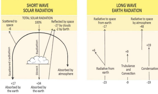
The Sun sends 100 units of energy to the top of Earth’s atmosphere. Here is how that energy is used or reflected:
1. 35 units are reflected back to space – this is known as the Earth’s albedo (its reflectivity):
- 27 units reflected by clouds .
- 06 units reflected by the atmosphere itself (gases, dust).
- 02 units reflected by ice, snow, and bright surfaces on Earth.
2. 14 units absorbed by the atmosphere – gases like ozone, carbon dioxide, and water vapor absorb this heat.
3. 51 units absorbed by the Earth’s surface – this includes both direct sunlight and scattered light that reaches the ground.
The total energy absorbed by Earth (51 + 14 = 65 units ) must eventually be sent back to space to keep the Earth’s temperature balanced.
C. Scattering of Solar Radiation
Scattering is the process by which sunlight is spread in different directions by air molecules, dust, and water vapor in the atmosphere.
1. Scattering makes the sky appear blue because blue light waves are scattered more than other colors.
2. Some scattered light goes into space, while some reaches the Earth’s surface as diffused sunlight .
3. It helps light reach areas under shade or clouds , which is why daylight is visible even when the Sun is not directly shining.
D. Outgoing Terrestrial (Longwave) Radiation
After absorbing solar energy, the Earth releases it back as longwave infrared radiation (heat energy). This process cools the Earth’s surface.
Out of the 51 units absorbed by Earth’s surface:
- 17 units are directly radiated into space .
- 34 units are transferred to the atmosphere as heat energy.
The atmosphere absorbs these 34 units in different ways:
1. 6 units are absorbed directly by greenhouse gases like carbon dioxide and water vapor.
2. 9 units are transferred through convection and turbulence – rising warm air carries heat upward.
3. 19 units come from latent heat of condensation – when water vapor condenses into clouds, heat is released into the air.
Total absorption by the atmosphere = 14 (from insolation) + 34 (from terrestrial radiation) = 48 units .
The atmosphere then radiates 48 units of heat back into space.
E. Overall Energy Balance
When we combine both the Earth’s surface and atmosphere:
- Total absorbed energy = 65 units (51 + 14).
- Total energy released to space = 65 units (48 from atmosphere + 17 from surface).
✅ This shows that the Earth’s energy system is balanced . This balance is the reason our planet’s average temperature remains steady around 15°C.
F. Latitudinal Heat Balance
The Sun does not heat all parts of the Earth equally:
1. Between 40° North and 40° South → Heat Surplus (more heat received than lost).
2. Near the Poles → Heat Deficit (more heat lost than received).
Without heat transfer, the tropics would keep getting hotter and the poles would become much colder.
G. Heat Redistribution Mechanisms
To maintain global temperature balance, the extra heat from tropical areas is moved toward the poles by:
1. Atmospheric circulation (about 75%) – winds, jet streams, cyclones, and weather systems move warm air from the equator toward higher latitudes.
2. Ocean currents (about 25%) – warm ocean currents like the Gulf Stream and Kuroshio Current carry heat from warm to cold regions.
These natural systems act like Earth’s “air-conditioners,” preventing extreme temperature differences between regions.
H. Significance of Heat Budget
1. Maintains Earth’s energy balance and overall temperature.
2. Supports life, agriculture, and ecosystems by keeping conditions stable.
3. Drives winds, rainfall, and ocean currents that shape global climate.
4. Prevents any part of the Earth from becoming permanently uninhabitable due to temperature extremes.
| Process | Units |
|---|---|
| Reflected by clouds | 27 |
| Reflected by atmosphere | 6 |
| Reflected by Earth surface (ice/land) | 2 |
| Absorbed by atmosphere | 14 |
| Absorbed by Earth’s surface | 51 |
| Re-radiated by Earth directly | 17 |
| Transferred to atmosphere | 34 |
| Re-radiated by atmosphere | 48 |
Prelims tips
- Earth’s albedo ~35% (27% clouds, 6% atmosphere, 2% surface).
- Earth’s surface absorbs 51 units; atmosphere absorbs 14 units directly.
- Atmosphere absorbs 34 units from terrestrial radiation (latent heat is major share).
- Latitudinal heat balance: Tropics surplus, poles deficit.
- 75% redistribution by atmosphere, 25% by oceans.
Mains points
- Earth maintains heat balance through equilibrium between incoming solar and outgoing terrestrial radiation.
- Albedo (35%) reflects part of incoming radiation; rest absorbed by surface (51%) and atmosphere (14%).
- Atmosphere absorbs additional energy via convection, turbulence, and latent heat of condensation.
- Latitudinal imbalance drives atmospheric circulation and ocean currents.
- Redistribution of heat prevents tropics from overheating and poles from extreme cooling.
- Understanding heat budget is vital for climate studies, monsoon systems, and global warming impacts.
Atmospheric Moisture – Hydrological Cycle
The hydrological cycle is the continuous circulation of water between the Earth’s surface and atmosphere through processes like evaporation, transpiration, condensation, precipitation, infiltration, and runoff.
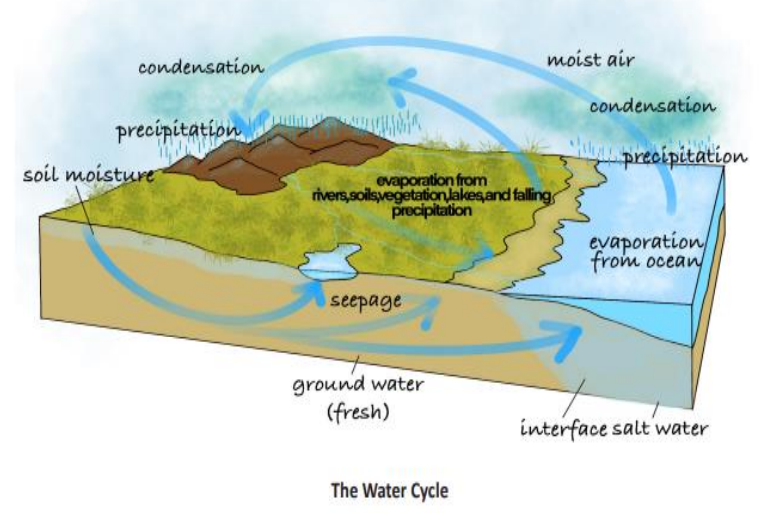
A. Definition
The Hydrological Cycle , also known as the Water Cycle , is the continuous and endless circulation of water between the Earth's surface, the atmosphere, and back again. It involves several processes that move water through its different forms — liquid, vapor, and ice — across oceans, land, and air.
In simple terms, water from oceans, lakes, and rivers evaporates, forms clouds, falls as rain or snow, and returns again through rivers and groundwater, maintaining the global water balance.
B. Steps Involved in the Hydrological Cycle
1. Evaporation: The Sun’s energy heats water bodies such as oceans, lakes, and rivers, causing water to change into vapor and rise into the atmosphere.
2. Transpiration: Plants also release water vapor through tiny pores called stomata during photosynthesis — this process is called transpiration.
3. Evapotranspiration: The combined process of evaporation from land and water surfaces and transpiration from plants.
4. Condensation: As water vapor rises, it cools and condenses into tiny droplets, forming clouds. This is where latent heat is released into the atmosphere, fueling weather systems.
5. Precipitation: When cloud droplets combine and grow large enough, they fall to Earth as rain, snow, sleet, or hail depending on temperature conditions.
6. Infiltration: Part of the precipitation seeps through soil and rocks into underground layers, becoming groundwater .
7. Runoff: Remaining water flows over the surface (surface runoff) or underground (subsurface flow) and eventually returns to oceans and seas, completing the cycle.
C. Importance of the Hydrological Cycle
1. Global Water Balance: It maintains equilibrium between evaporation and precipitation across the planet.
2. Freshwater Distribution: Responsible for the formation of rivers, lakes, and groundwater — crucial sources of drinking water.
3. Climate Regulation: Controls temperature and humidity by transferring heat and moisture in the atmosphere.
4. Soil Moisture Recharge: Helps maintain soil fertility, vital for agriculture.
5. Supports Ecosystems: Provides water for plants, animals, and all forms of life, ensuring biodiversity.
6. Energy Transfer: During condensation, latent heat is released — this drives storms, monsoons, and global wind patterns .
D. Major Water Reservoirs on Earth
1. Oceans: Contain about 97% of the Earth’s total water — mostly saline.
2. Ice Caps and Glaciers: Contain nearly 2% of Earth’s water in frozen form — a major part of the freshwater reserve.
3. Groundwater: Accounts for about 0.7% — a key source for drinking and irrigation.
4. Surface Water: Rivers, lakes, and ponds together form less than 0.01% but are vital for life.
5. Atmosphere: Contains a tiny fraction of water vapor, yet plays a major role in rainfall, storms, and weather systems.
E. Human Impacts on the Hydrological Cycle
1. Deforestation: Reduces transpiration, decreases local rainfall, and alters the natural water balance.
2. Over-extraction of Groundwater: Excessive pumping lowers water tables and causes aquifer depletion.
3. Urbanization: Paved surfaces prevent infiltration, increasing surface runoff and causing floods.
4. Pollution: Industrial waste and chemicals contaminate rivers and groundwater, reducing freshwater availability.
5. Climate Change: Raises global temperatures, leading to more intense evaporation and precipitation — causing droughts in some areas and floods in others.
6. Dam Construction: Alters natural river flow, disrupting the balance of evaporation, infiltration, and runoff.
F. Role in Global Heat and Moisture Transfer
1. The hydrological cycle acts as a natural heat engine for the planet.
2. When water vapor condenses into clouds, it releases latent heat , which powers storms, cyclones, and monsoon systems.
3. It helps in transferring heat energy from the equator (warm regions) to the poles (cold regions) , maintaining global temperature balance.
4. Thus, the water cycle not only regulates rainfall and humidity but also contributes significantly to Earth's climate stability.
G. Summary for Beginners
1. The hydrological cycle is a never-ending movement of water through evaporation, condensation, precipitation, and runoff.
2. It connects the oceans, atmosphere, and land in a continuous exchange of water and energy.
3. It is essential for life, agriculture, weather, and climate.
4. Human actions like deforestation and urbanization are disturbing this balance, leading to droughts, floods, and water scarcity.
| Reservoir | Percentage of Total Water |
|---|---|
| Oceans | 97% |
| Ice Caps & Glaciers | 2% |
| Groundwater | 0.7% |
| Surface Water (Rivers, Lakes) | <0.01% |
| Atmosphere | Trace but vital |
Prelims tips
- Evapotranspiration = evaporation + transpiration.
- Groundwater = infiltrated water stored underground.
- Latent heat of condensation drives monsoons & storms.
- Oceans hold ~97% of Earth’s water.
Mains points
- Hydrological cycle maintains global water and energy balance.
- Involves evaporation, transpiration, condensation, precipitation, infiltration, runoff.
- Distributes freshwater across rivers, lakes, groundwater.
- Human activities like deforestation and urbanization alter the cycle.
- Key link between atmosphere, lithosphere, and biosphere.
Humidity
Humidity is the amount of water vapor present in the air. It is expressed in different forms: absolute, specific, and relative humidity. Relative humidity is especially important for weather forecasting, cloud formation, and rainfall prediction.
A. Definition
Humidity refers to the amount of water vapor present in the air at any given time. It is one of the most important meteorological elements influencing weather, human comfort, and climate.
Water vapor is an invisible gaseous form of water, and its concentration varies depending on temperature, location, and proximity to water sources like oceans, lakes, and forests.
Humidity plays a major role in cloud formation, rainfall, and the Earth’s energy balance.
B. Different Expressions of Humidity
1. Absolute Humidity:
It is the mass of water vapor present in a unit volume of air.
Expressed in grams per cubic meter (g/m³) .
It tells how much water vapor is actually in a given air volume.
It decreases from the equator toward the poles due to temperature differences.
Absolute humidity changes with temperature and pressure — warm air can hold more water vapor.
Example: In humid tropical regions, absolute humidity is much higher than in polar regions.
2. Specific Humidity:
It is the mass of water vapor per unit mass of air (including dry air and water vapor).
Expressed in grams of water vapor per kilogram of air (g/kg) .
It does not change when air expands or contracts, making it useful for comparing humidity at different altitudes.
Example: Used in meteorological studies and weather forecasting for accuracy.
3. Relative Humidity (RH):
It is the ratio (in percentage) of the actual amount of water vapor present in the air to the maximum amount the air can hold at that temperature.
Formula: RH = (Actual Water Vapor / Maximum Water Vapor Capacity) × 100
Expressed in percentage (%) .
Relative humidity depends strongly on temperature — when temperature increases, the air’s capacity to hold moisture increases, lowering RH if vapor content remains constant.
Example: In summer, even with the same moisture content, RH is lower due to higher temperatures.
C. Factors Influencing Humidity
1. Temperature: Warm air can hold more moisture. Hence, tropical areas are more humid than polar regions.
2. Proximity to Water Bodies: Areas near seas, oceans, or lakes have higher humidity due to continuous evaporation.
3. Wind Direction: Moist winds from the sea increase humidity, while dry continental winds decrease it.
4. Vegetation: Plants release water vapor through transpiration, raising humidity in forested regions.
5. Altitude: As altitude increases, air becomes thinner and cooler, reducing its moisture-holding capacity and humidity.
6. Topography: Valleys and coastal areas often have higher humidity compared to mountains or plateaus.
D. Importance of Humidity
1. Weather Formation: High humidity helps in the formation of clouds, fog, and rainfall.
2. Agriculture: Humidity affects soil moisture, plant growth, and transpiration rate — crucial for crop yield.
3. Climate and Comfort: High humidity makes warm weather feel hotter (due to less evaporation of sweat), while low humidity causes dry skin and irritation.
4. Health: High RH favors fungal growth, mold, and respiratory issues; very low RH leads to dryness and dehydration.
5. Industrial Importance: Textile, printing, and electronic industries maintain controlled humidity levels to prevent damage to materials.
6. Natural Processes: Humidity regulates rainfall patterns and hydrological balance globally.
E. Measurement of Humidity
1. Hygrometer: General instrument used for measuring humidity levels.
2. Psychrometer: Uses two thermometers — one dry bulb and one wet bulb. The difference between their readings helps determine relative humidity.
3. Hair Hygrometer: Based on the principle that human or animal hair changes length with varying humidity levels.
4. Dew Point Measurement: The temperature at which air becomes saturated and condensation begins; indicates humidity indirectly.
F. Difference between Absolute and Relative Humidity
Absolute Humidity: Measures the actual amount of water vapor in the air. Expressed in g/m³. It is independent of temperature and shows how much water vapor is physically present.
Relative Humidity: Measures the percentage of water vapor the air holds relative to its maximum capacity at a given temperature. Expressed in %. It changes with temperature and indicates the likelihood of rainfall or dew formation.
G. Practical Examples
When warm moist air from the sea blows over land, RH increases and may lead to cloud formation and rain.
In deserts, despite high temperatures, RH remains very low — causing dryness and discomfort.
Air-conditioned rooms have low RH; hence humidifiers are used to maintain comfort.
During early morning, RH is highest; as the day progresses and temperature rises, RH decreases.
| Type | Definition | Unit/Expression |
|---|---|---|
| Absolute Humidity | Actual vapor in unit volume of air | g/m³ |
| Specific Humidity | Vapor in unit weight of air | g/kg |
| Relative Humidity | Percentage ratio of actual vapor to capacity | % |
Prelims tips
- Relative humidity decreases with rising temperature if moisture remains constant.
- Absolute humidity is not directly dependent on temperature.
- Relative humidity is crucial in forecasting rainfall, fog, and dew.
- Measured using hygrometers, psychrometers, and hair hygrometers.
Mains points
- Humidity regulates cloud formation, precipitation, and weather systems.
- Relative humidity is most relevant for human comfort and agriculture.
- Absolute humidity helps calculate precipitation potential.
- Specific humidity is useful in climate studies as it remains unaffected by volume changes.
- Variations in humidity influence local and global climate systems.
Phase Changes of Water
Water exists in three states – solid, liquid, and gas. The transformation between these states involves phase changes such as evaporation, condensation, sublimation, melting, freezing, and deposition, which play a critical role in the Earth’s atmospheric processes and energy balance.
A. Evaporation (वाष्पीकरण)
Evaporation is the process of converting liquid water into water vapor by the action of heat. It is a key part of the hydrological cycle and responsible for the transfer of water from oceans, rivers, and soil into the atmosphere.
Characteristics and Factors:
1. Process: Liquid water → Water vapor (on heating).
2. Faster in dry air: Since dry air has more capacity to absorb water vapor, evaporation is rapid in arid areas.
3. Higher over oceans: Due to vast water surfaces and wind action, oceans experience more evaporation than land areas.
4. Influencing Factors:
- Temperature: Higher temperature → faster evaporation.
- Humidity: Lower humidity → faster evaporation.
- Wind speed: Stronger winds remove saturated air → increases evaporation.
- Aridity: Dry climate promotes more evaporation.
5. Latent Heat of Vaporization: It is the energy absorbed during evaporation without changing temperature — this energy is stored in water vapor as latent heat and released later during condensation.
6. Significance: Evaporation cools the Earth’s surface (oceans, soil, and vegetation) and adds moisture to the atmosphere, influencing weather and climate.
B. Condensation (संघनन)
Condensation is the process by which water vapor changes back into liquid water when air cools down to its saturation point.
It is the reverse of evaporation and is responsible for cloud, fog, and dew formation.
How Condensation Occurs:
1. Cooling of moist air: When warm, moist air cools, its water vapor condenses into tiny water droplets.
2. Causes of Cooling:
- Air rises and expands adiabatically (without heat exchange).
- Warm air comes in contact with a colder surface (radiation cooling).
- Mixing of warm moist air with cold air.
3. Condensation Nuclei: Tiny particles like dust, smoke, sea salts, or CO₂ act as centers where water vapor condenses — these are called hygroscopic nuclei .
4. Latent Heat Release: During condensation, water vapor releases the same latent heat that was absorbed during evaporation — this energy drives cloud formation, rainfall, and storms.
5. Sublimation: When water vapor condenses directly into solid ice (without becoming liquid first), it is called sublimation .
C. Dew Point (ओसांक)
The Dew Point is the temperature at which air becomes saturated with water vapor and condensation begins.
Below the dew point, air cannot hold more moisture, leading to the formation of dew, fog, frost, or clouds depending on temperature conditions.
Example: On a cold morning, grass gets covered with dew when the air cools below its dew point.
If temperature is below 0°C, frost forms instead of dew.
D. Other Phase Changes of Water
1. Sublimation: Direct change from solid (ice/snow) to gas (water vapor) without becoming liquid. Common in very dry and cold regions such as the Himalayas and Antarctica.
2. Deposition: Direct change from water vapor to solid ice (e.g., frost formation on cold surfaces).
3. Freezing: Conversion of liquid water into ice. Heat is released during this process, known as the latent heat of fusion .
4. Melting: Ice changes into liquid water by absorbing heat (latent heat of fusion).
E. Significance of Phase Changes in the Atmosphere
1. Energy Balance: Evaporation absorbs heat (cooling effect), while condensation releases it (warming effect). Together, they regulate Earth’s energy balance.
2. Weather Formation: Condensation and freezing release latent heat, providing energy for cloud development, rainfall, cyclones, and thunderstorms.
3. Cooling Effect: Evaporation cools the Earth’s surface — especially oceans and plants — maintaining local temperature balance.
4. Polar & Glacial Processes: Sublimation and deposition influence snow, glaciers, and polar climate systems.
5. Climate Regulation: These phase changes are key in the hydrological cycle and help in transferring heat from equator to poles, stabilizing global climate.
F. Summary (For Beginners)
Evaporation = water turns to vapor (absorbs heat).
Condensation = vapor turns to liquid (releases heat).
Dew Point = temperature when condensation starts.
Sublimation/Deposition = direct change between solid and gas.
These processes together drive Earth’s water cycle and control weather and climate .
| Process | Change | Energy |
|---|---|---|
| Evaporation | Liquid → Gas | Absorbs latent heat (cooling) |
| Condensation | Gas → Liquid | Releases latent heat (warming) |
| Sublimation | Solid → Gas | Absorbs latent heat |
| Deposition | Gas → Solid | Releases latent heat |
| Freezing | Liquid → Solid | Releases latent heat of fusion |
| Melting | Solid → Liquid | Absorbs latent heat of fusion |
Prelims tips
- Evaporation absorbs heat, condensation releases heat.
- Dew point = temperature at which air becomes saturated.
- Hygroscopic nuclei essential for cloud formation.
- Latent heat drives monsoons, storms, and atmospheric circulation.
Mains points
- Phase changes of water are fundamental to weather and climate dynamics.
- Evaporation cools surfaces; condensation warms atmosphere.
- Latent heat exchange is critical for monsoon rainfall and storm systems.
- Processes like sublimation and deposition are vital in cryosphere and glacial studies.
- Understanding phase changes helps in predicting precipitation, fog, frost, and cloud dynamics.
Continental Drift Theory
Continental Drift Theory , proposed by Alfred Wegener in 1912 (published 1915), was the first comprehensive model explaining the movement and present configuration of continents. It posited that all landmasses were once joined as the supercontinent 'Pangaea' , surrounded by the ocean 'Panthalassa' .
I. Origin and Core Concept
Proponent: Proposed by German meteorologist Alfred Wegener in 1912, mainly to explain the similarity of climate evidence (paleoclimatic) found on vastly separate continents.
Pangaea: The single supercontinent that existed approximately 200 million years ago (Mya).
Panthalassa: The single vast global ocean surrounding Pangaea.
Driving Force: Wegener initially suggested the drift was caused by Tidal forces (due to Sun/Moon) and Pole-Fleeing Force (due to Earth's rotation/centrifugal force) – These forces were later proven insufficient to move continents.
II. Stages of Breakup (Post-Pangaea)
200 Mya (Triassic Period) : Pangaea began to break up.
It first split into two large continental masses:
1. Laurasia (Northern part: North America, Europe, Asia).
2. Gondwanaland (Southern part: South America, Africa, India, Australia, Antarctica).
Ocean Formation : The water body that separated Laurasia and Gondwanaland was the Tethys Sea (which later closed, leading to the formation of the Himalayas).
Mesozoic Era : The continents continued to drift, eventually leading to the present configuration.
III. Evidence Supporting the Theory
Jigsaw Fit (The Matching of Coasts) : The perfect morphological fit of the coasts, especially South America and Africa (Bullard's Fit in 1964 showed a near-perfect fit at the 200-fathom line).
Similarity of Rocks and Mountain Chains : Identical age and structure of rocks (e.g., Appalachians of North America and the Caledonides of Ireland/Scandinavia).
Placer Deposits : Rich gold placer deposits found on the Ghana coast have no source rock in Africa, suggesting the gold-bearing veins came from the separated Brazilian plateau.
Distribution of Fossils (Biological Evidence) : Identical species of plants and animals found across continents (e.g., Lystrosaurus fossil found in India, Africa, and Antarctica; Glossopteris flora found in Gondwanaland continents).
Paleoclimatic Evidence (Tillite) : Evidence of extensive, similar glacial till deposits (tillite) from the Permo-Carboniferous period found in tropical regions like India and Africa, indicating they were once near the South Pole.
| Element | Description |
|---|---|
| Pangaea | Supercontinent consisting of all present continents joined together. |
| Panthalassa | Vast global ocean surrounding Pangaea. |
| Laurasia | The Northern Supercontinent (post-Triassic split). |
| Gondwanaland | The Southern Supercontinent (post-Triassic split). |
| Tethys Sea | The water body that separated Laurasia and Gondwanaland. |
Prelims tips
- Continental Drift Theory was proposed by Alfred Wegener in 1912.
- The two major parts of Pangaea were Laurasia (North) and Gondwanaland (South).
- Evidence includes Jigsaw Fit, identical Fossils (Lystrosaurus, Glossopteris), and Tillite deposits.
- Wegener's proposed driving forces (Tidal forces and Pole-Fleeing Force) were later proven wrong.
Mains points
- Continental Drift Theory was revolutionary in establishing that continents move, laying the conceptual foundation for Plate Tectonics.
- Wegener successfully used geological and biological evidence (Paleomagnetism was not known to him) to support his hypothesis.
- The theory failed, however, to explain the actual mechanism for the drift, as the proposed forces were inadequate.
- The presence of coal deposits in polar regions and tillite in tropical regions strongly supported the concept of paleoclimatic shifts caused by continental movement.
Different Spheres of the Earth & Earth’s Interior
Earth consists of five main spheres — Geosphere, Biosphere, Hydrosphere, Atmosphere, and Cryosphere — which interact to support life and natural processes. Studying Earth’s interior helps us understand its physical features, resources, climate history, and planetary similarities.
Different Spheres of the Earth
Geosphere: Consists of Earth’s surface and interior made of rocks, extending from the deepest subsurface to the highest mountains. It drives tectonic cycles.
- Lithosphere: The rigid, solid outer layer of Earth, composed of the crust and the uppermost solid mantle. It is fractured into tectonic plates.
Biosphere: The zone where life exists, interacting with and permeating parts of the other spheres. It is responsible for biogeochemical cycling (Carbon, Nitrogen).
Hydrosphere: All water bodies (liquid, vapor, ice) covering Earth, including oceans (97%), rivers, lakes, groundwater, and atmospheric moisture. It regulates global heat distribution.
Atmosphere: Blanket of gases surrounding Earth (primarily Nitrogen and Oxygen), stratified into distinct layers (troposphere, stratosphere). It regulates temperature and protects the surface from cosmic rays.
Cryosphere: Frozen water regions like polar ice caps, glaciers, permafrost, and sea ice. It is a critical component of the climate system due to its high albedo (reflectivity).
Importance of Studying Earth’s Interior
Helps understand Earth’s physical features (e.g., tectonic activity, mountains, valleys, earthquakes, volcanoes), driven by mantle convection.
Provides knowledge about the evolution of life (utilizing fossils and the geological timescale) and the timing of major environmental shifts.
Enables exploration and extraction of minerals and energy resources (e.g., fossil fuels, metals) localized by internal geological processes.
Explains past climate changes (via ocean currents, volcanic aerosols) and helps predict future trends.
Offers insight into other rocky planets (Mercury, Venus, Mars also have rock composition), aiding comparative planetology.
Helps understand Earth’s magnetic field (generated by the liquid outer core) and planetary behavior, crucial for protecting life from solar radiation and particle wind.
| Sphere | Description |
|---|---|
| Geosphere | Earth’s rocks, interior, and lithosphere; drives plate tectonics. |
| Biosphere | Supports living organisms; regulates biogeochemical cycles. |
| Hydrosphere | Oceans, rivers, lakes, and water bodies; regulates global temperature. |
| Atmosphere | Air envelope surrounding Earth; controls weather and temperature. |
| Cryosphere | Frozen regions like ice caps and glaciers; influences global sea level. |
| Aspect | Reason |
|---|---|
| Tectonic Dynamics | Explains plate movement, geothermal energy, earthquakes, volcanoes. |
| Resource Localization | Guides the exploration of economically viable mineral and energy deposits. |
| Planetary Shield | Understanding the generation of the protective magnetic field by the liquid outer core. |
| Geologic Time | Dating of rocks and understanding the timeline of Earth's formation and life evolution. |
| Planetary Science | Similarity with Mercury, Venus, Mars in composition and differentiation. |
Prelims tips
- Earth has 5 main spheres: Geosphere, Biosphere, Hydrosphere, Atmosphere, Cryosphere.
- Lithosphere is the rigid outermost layer (Crust + uppermost solid mantle). The layer below it is the Asthenosphere (ductile/viscous mantle).
- Cryosphere's high Albedo (reflectivity) is crucial for regulating global temperature.
- The Magnetic Field is generated by the Convection of the Molten Iron in the Outer Core.
- Studying Earth’s interior primarily uses Seismology (Earthquake waves) as a direct method is impossible due to extreme temperature and pressure.
Mains points
- Earth’s spheres interact to regulate climate, ecosystems, and biogeochemical cycles, forming a complex interconnected system where changes in one sphere significantly impact others (e.g., melting Cryosphere raises Hydrosphere sea levels).
- The Geosphere provides tectonic stability and geothermal energy, driven by mantle convection that constantly reshapes the crust and influences rock cycles.
- The combined roles of the Hydrosphere and Atmosphere drive the distribution of global heat via ocean currents and atmospheric circulation, which directly dictates regional climate and biodiversity patterns.
- Studying Earth’s deep interior (seismology) reveals the differentiation process (layers) and the engine behind Plate Tectonics, which is the fundamental driver of Earth's dynamic surface features and long-term climate stability.
- Comparative planetology uses knowledge of Earth's active core-mantle system to infer why seemingly similar rocky planets (like Mars) lost their atmospheres and magnetic fields, highlighting Earth's uniqueness.
Seismic Waves
Seismic waves are energy shockwaves released during earthquakes from the focus. They travel at different speeds through different materials, recorded by a seismometer as a seismogram. Seismic waves are of two main types: Body waves (inside Earth) and Surface waves (on Earth’s surface). The difference in their propagation speed and medium proves the layered structure of the Earth.
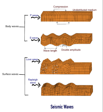
Overview
Seismic waves originate at the earthquake focus (hypocenter). They travel differently depending on the density, temperature, and physical state of the medium (solid, liquid, gas). Waves are recorded using a seismometer, which produces a trace called a seismogram — this record tells us how fast waves travel, how the ground moved, and what layers they passed through.
For UPSC beginners: Seismology is the primary indirect method for knowing Earth’s internal structure since we cannot physically drill deep (maximum drilling ≈ 12 km vs. Earth’s radius 6,371 km).
Types of Seismic Waves
1. Body Waves:
These waves travel through the interior of the Earth. Their speed and direction change with the density/elasticity of layers — this helps scientists map boundaries between crust, mantle, and core.
a) Primary Waves (P-waves):
- Longitudinal, compressional waves (push–pull movement).
- Travel the fastest; hence they are the first to reach seismological stations.
- Medium: Can move through solids, liquids, and gases (all states).
- UPSC Tip: P-wave velocity suddenly drops at the Mantle–Outer Core boundary (Gutenberg discontinuity), proving the Outer Core is less rigid.
b) Secondary Waves (S-waves):
- Transverse/shear waves (motion perpendicular to propagation).
- Slower than P-waves.
- Medium: Travel only through solids — cannot travel through liquids or gases.
- UPSC Gold Point: The absence of S-waves in large regions (S-wave Shadow Zone: 103°–142°) proves the Outer Core is liquid.
2. Surface Waves:
Generated when body waves interact with Earth’s surface. They travel along the crust and cause maximum destruction during earthquakes because of their large amplitude.
a) Love Waves: Horizontal shearing motion; extremely damaging to buildings because foundations cannot withstand sideward movement.
b) Rayleigh Waves: Elliptical, rolling motion similar to ocean waves; these cause buildings and the ground to sway.
🔬 UPSC Analysis: Seismic Evidence
The study of wave velocities, refraction, reflection, and Shadow Zones is the most reliable method of understanding the Earth's interior.
- P-wave Shadow Zone (103°–142°): Caused by refraction through liquid outer core.
- S-wave Shadow Zone (also 103°–142°): Exists because S-waves cannot pass through liquid outer core.
- Moho Discontinuity: Sharp increase in P-wave velocity between Crust and Mantle.
- Gutenberg Discontinuity: Drop in P-wave velocity where Mantle meets liquid Outer Core.
- Lehmann Discontinuity: Increase in P-wave speed marking the transition from liquid Outer Core to solid Inner Core.
These findings prove the Earth is a layered body with varying density and composition — fundamental for UPSC Prelims & Mains answers on 'Earth’s interior' and 'seismic evidence'.
| Type | Characteristics |
|---|---|
| P-waves (Primary) | Fastest, compressional, travel through solids, liquids, gases, used for deep interior study |
| S-waves (Secondary) | Slower, transverse, only through solids, used to prove liquid outer core |
| Love Waves | Surface, horizontal side-to-side, highly destructive to foundations |
| Rayleigh Waves | Surface, rolling elliptical motion, causes swaying of structures |
Prelims tips
- P-waves are fastest and first to reach seismograph. They are used for earthquake early warning.
- S-waves cannot pass through liquid $\implies$ evidence of the liquid outer core.
- Surface waves (Love and Rayleigh) are the most destructive despite being the slowest.
- The S-wave shadow zone is large ($103^{\circ}$ to $180^{\circ}$); the P-wave shadow zone is smaller ($103^{\circ}$ to $142^{\circ}$).
- P-wave refraction at the core-mantle boundary proves the transition to the solid inner core.
Mains points
- Seismology's Role: P and S waves are the only reliable indirect sources that reveal the internal mechanical properties, density, and state of matter (solid/liquid) of the Earth's deep interior layers.
- Internal Structure: The existence of the liquid outer core is a foundational discovery derived directly from the S-wave shadow zone, while P-wave refraction indicates the solid inner core.
- Damage Correlation: Although body waves carry immense energy, surface waves are the primary cause of structural collapse and damage, linking seismological theory directly to civil engineering and disaster management.
- Geodynamic System: Seismology connects earthquake analysis with Plate Tectonics and Mantle Convection, as P and S wave velocity changes reflect the ductile (Asthenosphere) and rigid (Lithosphere) mechanical layers.
Action of River Water – Basic Concepts
Rivers are dynamic systems and primary geomorphic agents shaped by gravity, draining precipitation from their source to their mouth. They perform crucial fluvial processes (erosion, transportation, deposition) and are a key part of the hydrological cycle. They form networks of tributaries, distributaries, drainage basins, and watersheds, playing a central role in shaping landscapes and human settlements.
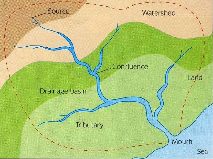
Basic Concepts (Recap)
River, source/headwaters, mouth, tributary, confluence, distributary, drainage basin, watershed, base level, graded profile, river regime — (see definitions).
Stream Order & Network
Strahler’s Stream Order: A system to classify streams — 1st order (no tributaries), 2nd order (confluence of two 1st-order), etc. Order correlates with discharge, channel size and sediment load.
Catchment Hydrology: Peak discharge, lag time, runoff coefficient depend on slope, soil, vegetation, drainage density and land use.
Drainage Patterns & Causes
Common patterns: Dendritic (homogeneous rock), Radial (volcanoes/ domes), Rectangular (jointed/faulted terrain), Trellis (folded mountains), Deranged (glacial/chaotic), Parallel (steep slope).
Pattern indicates geology and tectonic history — e.g., Trellis in folded Appalachians/Vindhyas; Radial around volcanic cones.
Work of a River — Processes
Erosion: Vertical (downcutting) in youthful stage, lateral in mature stages; processes include hydraulic action, abrasion, attrition, and solution (chemical).
Transportation: By traction (bouncing/rolling large clasts), saltation (short hops), suspension (fines carried in water), and solution (dissolved load).
Deposition: When velocity drops; forms bars, floodplains, deltas; deposition also within channel during low flow (point bars).
Longitudinal (Profile) Changes & Rejuvenation
Youthful: steep gradient, V-shaped valleys, rapids/waterfalls. Mature: gentler slope, wide valleys, meanders. Old age: wide floodplains, oxbow lakes, meander scars.
Rejuvenation: Renewed vertical erosion due to base-level fall (tectonic uplift, sea-level fall, or river capture) — produces entrenched meanders, river terraces and knickpoints (waterfalls).
Meanders, Oxbow Lakes & Floodplains
Meander dynamics: Erosion on outer bank (cut bank) and deposition on inner bank (point bar) cause lateral migration. Excess migration forms oxbow lakes when necks are cut.
Floodplains: Flat areas adjacent to channels formed by repeated flooding and overbank deposition (levees, backswamps). Natural fertility makes them agriculturally important but flood-prone.
Deltas & Estuaries
Delta types: Arcuate (Ganga–Brahmaputra — mixed/complex), Bird’s-foot (Mississippi — river-dominated), Cuspate (Tana, Kenya — wave-dominated), Tide-dominated (Ganges-Brahmaputra has tidal influences).
Estuaries: Funnel-shaped drowned river mouths with tidal mixing (e.g., Hooghly/Hooghly estuary). Estuaries are critical for fisheries, ports and mangrove ecosystems.
Special Phenomena
River capture (stream piracy): One river diverts headwaters of another due to differential erosion, changing drainage divides and basin area.
Nickpoints & Waterfalls: Local steep sections where rivers drop over resistant rocks or fault lines (e.g., Jog Falls, India).
Braided rivers: Multiple shallow channels separated by bars — occur with high sediment load and variable discharge (Brahmaputra upstream reaches).
Human Interaction & Management
Rivers provide water supply, irrigation, transport, hydroelectricity (dams/reservoirs), fisheries and fertile alluvium. Examples: Ganga basin — irrigation, navigation; Narmada/Tapti — hydropower projects.
River regulation (dams, embankments) reduces floods locally but can cause sediment trapping, delta subsidence, loss of wetlands, displaced communities and reduced downstream fertility.
Integrated River Basin Management (IRBM) aims to balance water use, ecology and livelihoods.
Hazards & Climate Change
Flooding (flash floods in steep catchments; monsoon floods in large plains), bank erosion, waterlogging, glacial lake outburst floods (GLOFs), and river avulsion. Climate change alters precipitation patterns, glacial melt and increases extreme events.
Economic & Environmental Significance
Rivers shape agricultural belts (Indo-Gangetic plains), sustain biodiversity (wetlands, mangroves), and determine urban settlement patterns. Rivers are central to water security, food production and disaster risk management.
UPSC/Exam Cues & Examples
- Ganga–Brahmaputra delta: largest delta — complex interplay of fluvial and tidal processes; Sundarbans mangroves and deltaic subsidence are key case-studies.
- Brahmaputra braiding: high sediment load + steep gradients in upper reaches; major channel migrations cause recurrent erosion and displacement in Assam.
- Deccan plateau rivers: peninsular rivers are seasonal, have lower drainage density and form peninsular plains withregen sloping profiles.
- Flood control trade-offs: embankments built on Ganga have reduced local flooding but increased catastrophic breaches and siltation downstream.
| Term | Definition | Example |
|---|---|---|
| River | Flowing body of water moving under gravity | Ganga, Nile, Amazon |
| Source | Point of river’s origin | Gangotri Glacier (Ganga), Lake Victoria (Nile) |
| Mouth | Where river ends into sea/lake/ocean | Ganga into Bay of Bengal (forms delta) |
| Tributary | Stream joining a larger river | Yamuna (tributary of Ganga) |
| Confluence | Meeting point of rivers | Prayagraj (Ganga, Yamuna, Saraswati) |
| Distributary | Branch flowing away from main river | Hooghly (from Ganga) |
| Drainage Basin | Area draining water into one river | Amazon Basin, Ganga Basin |
| Watershed | Boundary separating basins | Western Ghats, Ambala (separates Indus & Ganga basins) |
| Base Level | Lowest limit of river erosion | Ultimate: Sea Level; Local: Lake, Hard Rock |
| River Regime | Seasonal variation in river discharge | Himalayan (Perennial, snow-fed), Peninsular (Seasonal, rain-fed) |
Prelims tips
- Source = origin (e.g., glacier, spring); Mouth = where river drains (forms delta or estuary).
- Tributary (like Yamuna) adds water; Distributary (like Hooghly) branches off, usually in a delta.
- Drainage Basin = The entire area (catchment) draining into ONE river system (e.g., Ganga Basin).
- Watershed (Drainage Divide) = The highland boundary (e.g., Western Ghats) separating two basins.
- Base Level is the limit of erosion. Sea level is the ultimate base level.
- River Regime refers to the seasonal variation in water flow (discharge), crucial for water management and distinguishing Himalayan vs. Peninsular rivers.
Mains points
- Rivers are primary agents of fluvial geomorphology, creating erosional and depositional landforms (covered in next section).
- The concept of a Drainage Basin is fundamental to understanding water resource management, inter-state river disputes (e.g., Cauvery), and flood management.
- River Regime patterns (e.g., Peninsular vs. Himalayan rivers) directly impact agriculture, hydropower generation, and navigation.
- Understanding Base Level changes (e.g., due to climate change or tectonic uplift) is key to analyzing river rejuvenation and associated landforms (like river terraces).
- The Watershed concept is the basis for integrated resource management programs (e.g., Integrated Watershed Management Programme - IWMP) focusing on soil and water conservation.
- These concepts explain the formation of different drainage patterns (dendritic, trellis, radial, etc.), which reflect the underlying geology and topography of a region.
Movement of Ocean Water – Tides
The ocean acts like a giant liquid layer on Earth. Tides are the rhythmic rising and lowering of this water level, occurring twice a day. This happens because the Moon acts like a magnet pulling the water, and the Earth's rotation creates a force that pushes it back.
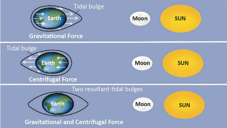
1. What exactly are Tides?
Imagine a glass of water. If you tilt it, water rises on one side and falls on the other. On Earth, gravitational forces 'tilt' the ocean water.
High Tide (Jwar): When the water level rises to its highest point and covers more of the beach.
Low Tide (Bhata): When the water recedes to its lowest point, exposing the seabed.
Tidal Range: The vertical difference in height between the High Tide and the Low Tide.
2. The Science: Why do they happen?
Two main forces work together to create tides:
A. Gravitational Pull (The Magnet):
The Moon is the main driver. Even though the Sun is bigger, the Moon is much closer, so its pull on oceans is 2.17 times stronger than the Sun's.
The Moon pulls the water on the side of Earth facing it, creating a Bulge (High Tide).
B. Centrifugal Force (The Spin):
Earth is spinning. Just like when you spin a bucket of water and the water pushes outwards, Earth's spin creates an outward force.
This force creates a second bulge on the opposite side of the Earth, away from the Moon. This ensures we have two high tides a day.
3. The Timing: Why not exactly 24 hours?
You might think tides happen at the same time every day, but they don't.
The Tidal Day: A tidal cycle takes 24 hours and 52 minutes.
Why the delay? While Earth rotates, the Moon also moves forward in its orbit. By the time Earth spins back to the same spot (24 hours later), the Moon has moved a bit further ahead. Earth takes an extra 52 minutes to catch up to the Moon's new position.
4. Types of Tides (Based on Sun-Moon Alignment)
The height of the tide changes depending on where the Sun, Moon, and Earth are standing.
A. Spring Tides (The Strongest Tides)
When: Full Moon (Purnima) and New Moon (Amavasya).
Alignment: The Sun, Moon, and Earth are in a Straight Line (called Syzygy).
Effect: The Sun and Moon pull together in the same direction. This creates the Highest High Tides and Lowest Low Tides (Maximum Tidal Range).
B. Neap Tides (The Weakest Tides)
When: 1st and 3rd Quarter of the Moon (Half Moon).
Alignment: The Sun and Moon are at Right Angles (90°) to each other.
Effect: The Sun's pull cancels out some of the Moon's pull (like a tug-of-war from sides). This creates Low High Tides and High Low Tides (Minimum Tidal Range).
5. Why are Tides Important?
Navigation: High tides raise water levels, helping big ships enter shallow harbors (e.g., Kandla Port and Diamond Harbour in India).
Fishing: Fish come closer to the shore during high tide to feed, helping traditional fishermen catch them easily.
Desilting: Tides rush in and out, naturally clearing mud and silt from river mouths (Estuaries), keeping them open for boats.
Energy: The strong force of moving tidal water can be used to generate electricity (Tidal Energy).
| Feature | Spring Tides (Dirgh Jwar) | Neap Tides (Laghu Jwar) |
|---|---|---|
| Position | Sun-Earth-Moon in Straight Line (180°) | Sun-Earth-Moon at Right Angle (90°) |
| Moon Phase | New Moon & Full Moon | 1st & 3rd Quarter |
| Tidal Range | Maximum (Very High Highs, Very Low Lows) | Minimum (Moderate tides) |
| Force | Constructive (Forces Add up) | Destructive (Forces Cancel out) |
Prelims tips
- Syzygy: The technical term for when the Sun, Earth, and Moon are in a straight line.
- Apogee vs Perigee: Tides are highest when the Moon is closest to Earth (Perigee - P for Pass/Near) and lower when it is farthest (Apogee - A for Away).
- Interval: Between a high tide and a low tide, there is a gap of approx 6 hours 13 minutes.
- Gulf of Khambhat: Has one of the highest tidal ranges in India.
Mains points
- Economic Geography: Discuss the role of tides in making riverine ports like Kolkata (Diamond Harbour) operational. Without tides, ships would get stuck in silt.
- Renewable Energy: Tides are a predictable source of energy. India has potential in the Gulf of Khambhat and Gulf of Kutch, though currently underutilized.
- Ecology: Tidal mixing is crucial for mangroves (Sundarbans). It brings nutrients from the sea and flushes out toxins from the fresh water.
Types of Tides (Based on Frequency)
Tides don't behave the same way everywhere. Some places see water rise twice a day, others only once. This classification is based on how many times high and low tides occur in a 24-hour period.
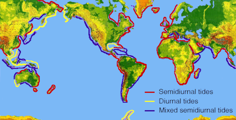
1. Semidiurnal Tide (The Regular Pattern)
What is it? 'Semi' means half. This pattern repeats every half-day.
Pattern: 2 High Tides + 2 Low Tides every 24 hours.
Height: The two high tides are roughly the same height.
Where: This is the most common type. Found along the Atlantic Coast (USA, Europe) and Indian Coast.
2. Diurnal Tide (The Daily Pattern)
What is it? 'Diurnal' means daily. This pattern happens only once a day.
Pattern: 1 High Tide + 1 Low Tide every 24 hours.
Where: Rare. Found in the Gulf of Mexico and parts of Southeast Asia.
3. Mixed Tide (The Uneven Pattern)
What is it? A mix of the two patterns above.
Pattern: 2 High Tides + 2 Low Tides, BUT they are of unequal heights.
Visual: Imagine having breakfast and dinner, but breakfast is a huge feast (High High Tide) and dinner is just a snack (Low High Tide).
Where: Pacific Coast of North America and many Pacific islands.
| Type | Frequency (per 24 hrs) | Key Feature |
|---|---|---|
| Semidiurnal | 2 High, 2 Low | Heights are equal |
| Diurnal | 1 High, 1 Low | Occurs once a day |
| Mixed | 2 High, 2 Low | Heights are unequal |
Prelims tips
- Semidiurnal tides are the most common type globally.
- Indian Coast: Generally experiences semidiurnal or mixed tides.
- Diurnal tides are rarer, mostly found in enclosed seas like the Gulf of Mexico.
Mains points
- Coastal Management: Knowing the frequency is vital for port authorities to schedule ship docking.
- Ecosystems: Intertidal zones (areas exposed during low tide) rely on this frequency for feeding cycles of crabs and birds.
Types of Tides (Based on Height)
The height of tides changes throughout the month. When the Sun and Moon pull together, tides are huge (Spring Tides). When they fight each other, tides are weak (Neap Tides). This cycle happens every month.
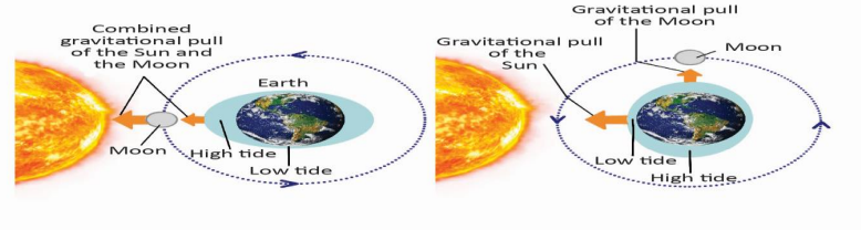
1. Spring Tides (The Strongest)
Don't get confused: 'Spring' has nothing to do with the season. It comes from the word 'springing forth' (jumping up).
When: Twice a month (New Moon & Full Moon).
Alignment: Sun, Moon, and Earth are in a straight line (called Syzygy).
Mechanism: The Sun helps the Moon. It's like two people pulling a rope in the same direction. ($1 + 1 = 2$).
Result: The water bulges significantly. High tides are very high; low tides are very low (Maximum Range).
2. Neap Tides (The Weakest)
When: Twice a month (1st and 3rd Quarter Moon - Half Moon).
Alignment: Sun and Moon make a 90° angle with Earth.
Mechanism: The Sun pulls water one way, the Moon pulls another way. They cancel each other out partially.
Result: The difference between high and low tide is very small.
3. Apogee and Perigee (Distance Matters)
The Moon's orbit is oval, not a perfect circle. Distance affects the pull.
Perigee (Near): Moon is closest to Earth. Tides are much higher. (Memory Tip: 'P' for Pass/Near).
Apogee (Far): Moon is farthest. Tides are lower. (Memory Tip: 'A' for Away).
| Feature | Spring Tide | Neap Tide |
|---|---|---|
| Moon Phase | Full / New Moon | Quarter Moon |
| Sun-Moon Angle | 0° or 180° (Straight) | 90° (Right Angle) |
| Tidal Range | Maximum (Extreme) | Minimum (Moderate) |
| Force | Additive (Combined) | Subtractive (Opposing) |
Prelims tips
- Frequency: There is a 7-day gap between a Spring Tide and a Neap Tide.
- Syzygy: Remember this term. It specifically refers to the straight-line alignment causing Spring Tides.
- Perihelion/Aphelion: Similarly, when Earth is closest to the Sun (Perihelion - Jan 3), solar tides are stronger.
Mains points
- Navigation Safety: Ships often wait for Spring Tides to enter shallow rivers (like the Hooghly in Kolkata) because the water level is higher.
- Energy Potential: Tidal power plants work best in areas with a large difference between high and low tides (High Tidal Range).
Factors Affecting Climate (Beginner's Guide)
Why is Kashmir cold and Chennai hot? Why does Mumbai have sticky heat while Delhi has dry heat? The climate isn't random; it is cooked up by a specific recipe of factors like Distance from the Sun (Latitude), Height (Altitude), and Distance from the Sea.
1. Latitude (Distance from Equator)
The Concept: The Earth is round. The Equator is like the 'belly' of the Earth that sticks out towards the sun.
Direct Rays: At the Equator, sun rays hit straight on (like a focused flashlight beam). This creates intense heat.
Slanting Rays: As you move towards the Poles (North/South), the earth curves away. Sun rays hit at a slant/angle (spread out like a weak flashlight beam). This makes these areas colder.
2. Altitude (Height from Sea Level)
The Rule: The higher you go, the cooler it gets. Temperature drops by roughly 6.5°C for every 1 km you climb.
Why? The atmosphere is like a blanket. Near the ground (plains), the air is thick and holds heat. High up (mountains), the air is thin and cannot hold heat.
Example: Ooty is much cooler than Chennai, even though they are roughly at the same latitude, because Ooty is high up on hills.
3. Distance from the Sea (Continentality)
Land vs. Water: Land heats up very fast and cools down very fast. Water takes a long time to heat up and cool down.
Coastal Areas (Mumbai/Chennai): The sea acts like an air conditioner. In summer, the cool sea breeze keeps the land cool. In winter, the warm sea keeps the land warm. Result: Moderate Climate (Neither too hot, nor too cold).
Interior Areas (Delhi/Punjab): Far from the sea, there is no moderating effect. Result: Extreme Climate (Very hot summers, very cold winters).
4. Prevailing Winds
Think of winds as 'delivery trucks'. What they deliver depends on where they come from.
On-shore Winds (From Sea): They carry moisture/water vapor. They deliver Rain.
Off-shore Winds (From Land): They are dry. They bring dry weather.
5. Ocean Currents
The ocean has giant rivers flowing inside it, called currents.
Warm Currents: If a warm current flows past a coast, it warms up the air and brings rain (e.g., Gulf Stream keeps Europe warm).
Cold Currents: If a cold current flows past a coast, it cools the air and prevents rain, often creating deserts (e.g., Atacama Desert is caused by the cold Peru Current).
6. Mountain Ranges (The Barrier)
Mountains act like a wall blocking the wind.
Windward Side: The side facing the wind gets blocked. The air is forced to rise, cool down, and drop all its rain here. (Heavy Rainfall).
Leeward Side (Rain Shadow): By the time the wind crosses the mountain, it is dry. This side gets very little rain. (Dry/Desert-like).
Example: Mumbai (Windward) gets heavy rain. Pune (Leeward), just a few hours away, gets much less rain.
| Factor | Effect | Real Life Example |
|---|---|---|
| Latitude | Equator = Hot; Poles = Cold | Why Canada is colder than India. |
| Altitude | Higher = Colder | Why Shimla is cooler than Chandigarh. |
| Distance from Sea | Near Sea = Mild; Far Away = Extreme | Why Mumbai has no real winter, but Delhi freezes. |
| Mountains | Blocks wind to cause rain | Why Western Ghats are green, but Deccan Plateau is dry. |
Prelims tips
- Most Basic Factor: Latitude is the most fundamental factor controlling temperature globally.
- Lapse Rate: The rate at which temperature drops with height (6.5°C per km).
- Rain Shadow: The dry area on the back side of a mountain (Leeward side).
- Continentality: The effect of being far from the sea (Extreme heat and cold).
Mains points
- Interconnectedness: Climate isn't shaped by one factor. Example: The UK is at a high latitude (should be freezing) but is kept warm by the Gulf Stream ocean current.
- Human Impact: While these are natural factors, humans are changing 'Land Use' (cutting forests, concreting cities), which creates 'Urban Heat Islands', artificially changing the local climate.
- Agriculture: Farmers must choose crops based on these factors (e.g., apples in high altitude Kashmir, coconuts in coastal Kerala).
India’s Size and Extent (Beginner's Guide)
India is a massive country (7th largest in the world) holding 2.4% of Earth's land. Its location on the globe determines our climate variations (from snowy north to tropical south) and our time zones.
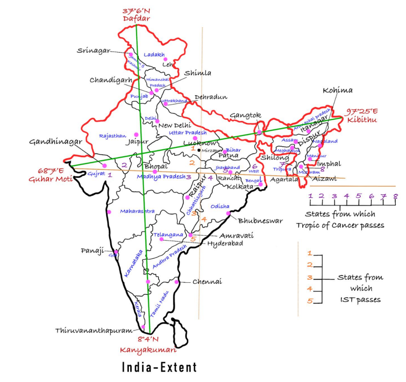
1. How Big is India? (Global Context)
Global Rank: 7th largest country by area. The only countries bigger are Russia, Canada, USA, China, Brazil, and Australia.
Total Area: 3.28 million sq. km.
Interesting Fact: India has only 2.4% of the world's land but supports nearly 18% of the world's population, making our land very resource-intensive.
2. Dimensions: Length and Width
North to South: From Indira Col (Ladakh) to Kanyakumari is approx 3,214 km.
East to West: From Kibithu (Arunachal Pradesh) to Guhar Moti (Gujarat) is approx 2,933 km.
The Grid: India is located entirely in the Northern Hemisphere.
3. The Time Confusion (Why do we need IST?)
The Problem: The Earth rotates from West to East. The sun rises in Arunachal Pradesh (East) about 2 hours before it rises in Gujarat (West).
The Math: There is a gap of 30° longitude between East and West. Since Earth takes 4 minutes to rotate 1°: 30° × 4 min = 120 min (2 hours)
The Solution (IST): To avoid confusion, India uses a single time based on the center line (Standard Meridian) at 82°30’E.
Where is it? This line passes through Mirzapur (Uttar Pradesh).
4. The Climate Divider: Tropic of Cancer
The Tropic of Cancer (23°30’N) cuts India horizontally into two halves:
- Northern Half: Sub-tropical climate (Hot summers, cold winters).
- Southern Half: Tropical climate (Warm year-round, no harsh winter).
8 States it touches: Gujarat, Rajasthan, Madhya Pradesh, Chhattisgarh, Jharkhand, West Bengal, Tripura, and Mizoram.
5. Boundaries
Land Borders: ~15,200 km (Shared with Pakistan, Afghanistan, China, Nepal, Bhutan, Myanmar, Bangladesh).
Coastline: ~7,516 km. This long coastline is crucial for trade with the Middle East and Southeast Asia.
| Direction | Place | Key Fact |
|---|---|---|
| North | Indira Col (Ladakh) | High altitude mountain pass |
| South (Mainland) | Kanyakumari (Tamil Nadu) | Meeting point of 3 seas |
| South (Total) | Indira Point (Nicobar Islands) | Submerged in 2004 Tsunami |
| East | Kibithu (Arunachal Pradesh) | First sunrise in India |
| West | Guhar Moti (Gujarat) | Salt marsh region |
Prelims tips
- Confusing Point: If asked for the southernmost point, check if they mean 'Mainland' (Kanyakumari) or 'Indian Union' (Indira Point).
- Time Calculation: Remember 1° = 4 minutes. This formula is often asked in exams to calculate time differences.
- Tropic of Cancer: Does NOT pass through Odisha or Manipur (common trick options in exams).
Mains points
- Impact of Latitudinal Spread: Explain how the North-South spread creates distinct climate zones (Kashmir's cold vs. Kerala's heat) and affects agriculture patterns.
- Time Zone Debate: Discuss why some argue for a separate time zone for the North-East (to save daylight) vs. the administrative convenience of a single IST.
- Strategic Location: India's central location in the Indian Ocean allows it to connect the West (Europe/Middle East) with the East (Asia-Pacific).
India as a Tropical Country & Its Neighbors (Beginner's Guide)
Even though the northern part of India lies in the 'Sub-tropical' zone, the whole country is treated as a Tropical Country. This is because the Himalayas act as a massive wall blocking cold air, and the Monsoons (seasonal winds) control our agriculture and seasons.
1. Why is India considered 'Tropical'? (The Logic)
Geographically, the Tropic of Cancer divides India. The North is 'Temperate/Sub-tropical' and the South is 'Tropical'. However, we study India as a tropical entity for two main reasons:
A. Physical Reasons (Climate & Geography)
1. The Himalayan Wall: The Himalayas act as a giant barrier in the North. They stop freezing cold winds from Central Asia and China from entering India. This keeps Northern India much warmer than other places at the same latitude.
2. The Monsoon Effect: The entire country, from Kerala to Delhi, is influenced by the Tropical Monsoon winds. The rhythm of seasons (Summer, Rain, Winter) is similar across the land.
3. Peninsular Shape: South India is surrounded by water on three sides (Arabian Sea, Indian Ocean, Bay of Bengal). This water regulates the temperature, keeping it warm and humid—typical of tropical regions.
B. Cultural Reasons (Life & Habits)
1. Agriculture: Our main crops are tropical. For example, Rice and Sugarcane require high heat and lots of water.
2. Diseases: Unfortunately, tropical climates breed specific mosquitoes. Diseases like Malaria and Dengue are common across India.
3. Daily Life: Our food (spicy to induce sweating/cooling), our clothes (cotton), and our festivals (Harvest festivals like Pongal/Bihu) are all designed around the tropical monsoon cycle.
2. India's Neighbors: Who is next door?
India shares its borders with 9 countries in total: 7 on land and 2 across the sea.
The 'Bachpan MBA' Trick
To remember the land borders from Longest to Shortest, use the mnemonic 'Bachpan MBA':
- Ba: Bangladesh (4,096 km) - Longest
- Ch: China (3,488 km)
- Pa: Pakistan (3,323 km)
- N: Nepal (1,751 km)
- M: Myanmar (1,643 km)
- B: Bhutan (699 km)
- A: Afghanistan (106 km) - Shortest
| Country | Border Length (km) | Bordering States/UTs | Facts | Major Issues |
|---|---|---|---|---|
| Afghanistan | 106 | Ladakh (Gilgit-Baltistan under Pakistan) | Shortest border, Durand Line (1893) | Entire stretch under Pakistan’s illegal occupation |
| China | 3488 | Ladakh, Himachal Pradesh, Uttarakhand, Sikkim, Arunachal Pradesh | Separated by LAC; disputed in Aksai Chin and Arunachal Pradesh | 1962 war; Galwan clash 2020; China claims Arunachal as 'South Tibet' |
| Nepal | 1752 | Uttarakhand, Uttar Pradesh, Bihar, West Bengal, Sikkim | Defined by Treaty of Sugauli (1816) | Kalapani-Limpiyadhura-Lipulekh & Susta disputes |
| Bhutan | 699 | Assam, Arunachal Pradesh, West Bengal, Sikkim | Peaceful border; India provides security assistance | China’s attempts in Doklam (2017 standoff) |
| Bangladesh | 4098 | Assam, Tripura, Mizoram, Meghalaya, West Bengal | Longest border; settled enclaves via 2015 Land Boundary Agreement | Illegal migration, river water sharing (Teesta issue) |
| Myanmar | 1643 | Arunachal Pradesh, Nagaland, Manipur, Mizoram | Border runs along Brahmaputra–Irrawaddy watershed | Cross-border insurgency, drug & arms trafficking |
| Sri Lanka | Maritime | Tamil Nadu (via Palk Strait) | Connected by Adam’s Bridge/Ram Setu | Kachchatheevu Island issue, Tamil fishermen arrests |
| Pakistan | 3323 | J&K, Punjab, Rajasthan, Gujarat | Borders include IB, LoC, Sir Creek | Terrorism, PoK & Gilgit-Baltistan, Sir Creek maritime dispute, Siachen Glacier conflict |
Prelims tips
- Sri Lanka Connection: India is connected to Sri Lanka by a chain of limestone shoals known as Ram Setu (Adam's Bridge).
- Tripura Fact: Tripura is surrounded by Bangladesh on 3 sides. It is like a finger pointing into Bangladesh.
- Sikkim's Neighbors: Sikkim is the only state bordered by 3 countries: Nepal (West), China (North), and Bhutan (East).
- The Chicken's Neck: The Siliguri Corridor in West Bengal is a very narrow strip connecting India to the North-East. If blocked, the North-East gets cut off.
Mains points
- Neighborhood First Policy: Explain why India prioritizes helping neighbors (like Nepal/Bhutan) to keep Chinese influence away.
- Border Security vs Trade: Discuss the challenge of keeping borders secure (from terrorists/smugglers) while keeping them open for trade (like with Nepal).
- Strategic Geography: Mention how India's location allows it to monitor the Indian Ocean, through which most of the world's oil trade passes.
Himalayas
The Himalayas (meaning 'Abode of Snow') are the world’s youngest, highest, and longest fold mountain system, formed through the collision of the Indian Plate with the Eurasian Plate. They continue to rise due to ongoing plate tectonics.
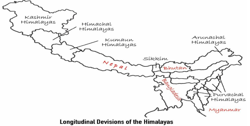
Origin of the Himalayas
Based on Continental Drift Theory and Plate Tectonics.
About 200 million years ago: The supercontinent Pangea split into Laurasia (North) and Gondwanaland (South).
A long ocean called the Tethys Sea existed between them, where thick layers of sediments and marine organisms accumulated for millions of years.
The Indian Plate broke away from Gondwanaland and drifted northward at a fast rate.
Around 50 million years ago, the Indian Plate collided with the Eurasian Plate.
Since both plates are continental and light, no subduction occurred. Instead, the Tethys Sea sediments were compressed and folded upward to form the Himalayas.
Thus, the Himalayas are an example of continent–continent convergence.
Geological Evidence
Marine fossils such as ammonites and shells found in the Himalayas prove that the region was once covered by the Tethys Sea.
Presence of rock formations from Precambrian to recent times shows continuous geological evolution.
Highly folded, uplifted, and faulted rocks indicate strong compressional forces typical of convergent boundaries.
Evidence That the Himalayas Are Still Rising
The Indian Plate continues to move northwards at about 5 cm per year, pushing the Himalayas upward.
Similar fossils found in the Shiwalik hills and Tibetan Plateau indicate uplift over time.
Ancient lake deposits in Tibet show that large freshwater lakes once existed but drained as the land rose.
The Himalayas are among the most seismically active regions of the world due to ongoing plate collision.
Rivers like the Indus, Ganga, and Brahmaputra carve deep V-shaped valleys, proving the mountains are still rising and young.
Physiographic Divisions of the Himalayas
Trans-Himalayas: Includes Karakoram, Ladakh, and Zaskar ranges; dry, cold, and high-altitude region.
Greater Himalayas (Himadri): Highest range; contains Mt. Everest, Kanchenjunga; has permanent snow and glaciers.
Lesser Himalayas (Himachal): Includes Pir Panjal and Dhauladhar; contains hill stations like Shimla and Mussoorie.
Shiwaliks: Youngest Himalayas; made of loose sediments; prone to landslides; contain longitudinal valleys (Duns).
Eastern Hills (Purvanchal): Includes Patkai, Naga, Mizo, and Manipur hills; formed by bending of Himalayas towards the south.
Significance of the Himalayas
Climatic Barrier: Protects India from cold Siberian winds; causes orographic rainfall during monsoon.
Source of Major Rivers: Indus, Ganga, Yamuna, and Brahmaputra originate from Himalayan glaciers.
Biodiversity Hotspot: Home to diverse flora and fauna like snow leopard, red panda, medicinal plants.
Natural Resources: Forests, herbs, minerals (limited), and vast hydropower potential.
Strategic Importance: Forms a natural frontier with China, Nepal, and Bhutan; crucial for national security.
Cultural Importance: Includes sacred sites like Kailash, Amarnath, Kedarnath, and Mansarovar.
| Aspect | Details |
|---|---|
| Meaning of Name | Himalaya = Abode of Snow |
| Type | Young fold mountain system |
| Age | Formed ~40–50 million years ago |
| Origin | Collision of Indian & Eurasian Plates |
| Geological Evidence | Marine fossils, folded sediments |
| Ongoing Rise | Indian Plate moves ~5 cm/year |
| Divisions | Trans, Greater, Lesser, Shiwaliks, Purvanchal |
| Importance | Climate, rivers, biodiversity, culture, defense |
Prelims tips
- Himalayas are the youngest fold mountains (~50 million years old).
- Formed by collision of Indian Plate with Eurasian Plate (Continental Drift Theory).
- Divisions: Trans, Greater (Himadri), Lesser (Himachal), Shiwaliks, Purvanchal.
- Indian Plate still moving northwards at ~5 cm/year.
- Marine fossils in Himalayas indicate Tethys Sea origin.
Mains points
- Himalayas are a product of plate tectonics and continental drift.
- They continue to rise due to northward movement of the Indian Plate.
- They play a critical role in India’s climate, river systems, biodiversity, and defense.
- Frequent earthquakes highlight tectonic instability in the region.
- Physiographic divisions show geological diversity and ecological significance.
- Himalayas symbolize cultural and spiritual heritage of India.
Divisions of the Himalayas: Greater, Lesser & Outer (Beginner's Guide)
Think of the Himalayas not as one mountain, but as a Three-Step Staircase rising from the Indian plains towards China. The lowest step is the Shiwalik (Outer), the middle step is the Lesser Himalayas (Himachal), and the highest step is the Great Himalayas (Himadri). Together, they form the physical backbone of India.
1. The Concept of Three Parallel Ranges
If you slice the Himalayas from North to South, you won't see just one peak. You will see three distinct parallel lines of mountains.
Order from North to South:
1. Greater Himalayas (Highest, snowy, oldest)
2. Lesser Himalayas (Rugged, hill stations)
3. Outer Himalayas (Lowest, muddy, youngest)
2. The Greater Himalayas (Himadri)
Also known as: Inner Himalayas or Himadri (Sanskrit for 'Abode of Snow').
Location: The northernmost wall.
Key Features for Beginners:
- The Solid Wall: It is the most continuous range. There are very few gaps (passes) to cross it.
- The Core: Inside these mountains, the rock is hard Granite. This strong core helps them stand so tall.
- Asymmetry: The side facing India is very steep (like a wall), while the side facing Tibet slopes down gently.
- Famous Peaks: This range holds Mt. Everest (8848m), Kanchenjunga, and Nanga Parbat.
3. The Lesser Himalayas (Himachal)
Also known as: Middle Himalayas.
Location: Sandwiched between the Great Himalayas (North) and Shiwaliks (South).
Key Features for Beginners:
- The Tourist Belt: Most famous hill stations like Shimla, Mussoorie, Nainital, and Darjeeling are located here because the height (3700-4500m) is pleasant, not freezing like Himadri.
- The Vegetation Mystery:
- North-facing slopes: Have dense forests (because they get less direct sun, so soil stays moist).
- South-facing slopes: Are steep and often bare/grassy (because direct sun dries them out).
- Major Ranges: The Pir Panjal (Kashmir) and Dhauladhar (Himachal) are parts of this layer.
4. The Outer Himalayas (Shiwalik)
Also known as: The Foothills or Manak Parbat.
Location: The southernmost edge, right next to the plains of UP, Punjab, etc.
Key Features for Beginners:
- The Youngest: These mountains formed last.
- Made of 'Debris': While Himadri is made of hard rock, Shiwalik is made of loose mud, gravel, and stones brought down by rivers from the upper mountains. Because the soil is loose, Landslides are very common here.
- Disappearing Act: The Shiwalik range is wide in the West (Himachal/Punjab) but becomes very narrow or merges completely with the Lesser Himalayas in the East (Arunachal Pradesh).
5. Important Geographical Terms (The 'Duns' and 'Chos')
A. What is a 'Dun'?
- Imagine a flat valley nestled lengthwise between the Lesser Himalayas and the Shiwaliks. This structural valley is called a 'Dun'.
- Example: Dehra-dun, Patli-dun.
B. What is a 'Duar'?
- In the East (Bengal/Assam), these flat foothills are called 'Duars' (meaning 'Doors' to Bhutan). They are famous for Tea Gardens.
C. What are 'Chos'?
- In Punjab and Himachal, during monsoons, temporary streams rush down the Shiwalik slopes, cutting deep gullies in the soft soil. These destructive streams are called Chos.
| Range Name | Avg Height | Composition (Made Of) | Famous For |
|---|---|---|---|
| Greater (Himadri) | 6000 m (Highest) | Granite (Hard Rock) | Mt. Everest, Glaciers (Siachen), & Perpetual Snow. |
| Lesser (Himachal) | 3700–4500 m | Metamorphic Rocks | Hill Stations (Shimla, Mussoorie), Valleys (Kullu). |
| Outer (Shiwalik) | 900–1100 m (Lowest) | Loose Mud & Stones | Duns (Dehradun) & Foothills prone to landslides. |
Prelims tips
- Sequence Rule: Always remember the order North to South: Himadri -> Himachal -> Shiwalik.
- The Missing Link: The Shiwalik range is NOT continuous. It disappears near the Tista river in the East.
- Soil Type: Shiwalik = Unconsolidated (Loose) sediments. Himadri = Granite (Hard).
- Karewas: The Kashmir Valley (Lesser Himalayas) is famous for 'Karewa' soil deposits, which are excellent for growing Saffron (Zafran).
Mains points
- Tourism vs Ecology: The Lesser Himalayas are under huge stress due to tourism (hotels/roads). Discuss the need for sustainable tourism.
- Disaster Management: The Shiwaliks are made of loose soil. Explain why road construction here leads to frequent landslides during monsoons.
- Hydro Potential: The steep drop from Greater to Lesser Himalayas creates fast-flowing rivers, ideal for Hydroelectric Power Plants.
Passes in the Himalayas
A Pass (often called 'La' in Tibetan) is a natural gap or low point in a mountain range that allows people to cross from one side to the other. Without these passes, the Himalayas would be a giant wall impossible to cross. They are the lifelines for trade, military, and travel.
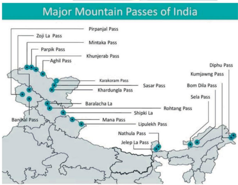
1. What is a Mountain Pass?
Think of a mountain range as a high wall. A Pass is like a 'Door' or 'Gate' in that wall.
Origin of the word 'La': In the Himalayas, you will hear names like Zoji La, Nathu La. The word 'La' literally means 'Pass'. So saying 'Zoji La Pass' is actually saying 'Zoji Pass Pass'!
2. Passes in J&K and Ladakh (The Western Gateways)
This region is critical for defense and connects India to Central Asia.
A. Banihal Pass (J&K):
- Connects: Jammu to Srinagar (Kashmir Valley).
- Significance: It remains open mostly year-round due to the Jawahar Tunnel. It is the main entry into Kashmir.
B. Zoji La (Ladakh):
- Connects: Srinagar to Leh (Ladakh).
- Significance: Known as the 'Gateway to Ladakh'. It is strategically vital for the military to send supplies to Ladakh/Kargil.
C. Khardung La (Ladakh):
- Connects: Leh to Siachen Glacier.
- Fame: Famous as one of the highest motorable roads in the world. Bikers love this route.
3. Passes in Himachal Pradesh (The Tourist & Trade Routes)
A. Rohtang Pass:
- Connects: Kullu Valley to Lahaul & Spiti.
- Significance: Very famous for tourism. However, it gets blocked by snow in winter. The new Atal Tunnel now goes under this pass to provide all-weather connectivity.
B. Shipki La:
- Connects: Shimla (India) to Tibet (China).
- Significance: This is where the mighty River Sutlej enters India from Tibet.
C. Baralacha La:
- Connects: Mandi (HP) to Leh (Ladakh).
- Significance: It is a high-altitude crossroads connecting three different mountain ranges.
4. Passes in Uttarakhand (The Pilgrim Routes)
A. Lipulekh Pass:
- Connects: Uttarakhand to Tibet.
- Significance: It is located at the tri-junction of India, Nepal, and China. Famous for the Kailash-Mansarovar Yatra.
B. Mana Pass & Niti Pass:
- Connects: Uttarakhand to Tibet.
- Significance: Mana is often called the 'Last Village of India'.
5. Passes in the North-East (Sikkim & Arunachal)
These passes are crucial for trade with China and Myanmar.
A. Nathu La (Sikkim):
- Connects: Sikkim to Tibet.
- History: Part of the ancient Silk Route. It was closed after the 1962 war but reopened in 2006 for trade. It is a major border personnel meeting point.
B. Jelep La (Sikkim):
- Connects: Sikkim to Lhasa (Tibet).
- Geography: Passing through the Chumbi Valley.
C. Bom Di La (Arunachal Pradesh):
- Connects: Arunachal to Lhasa (Tibet).
D. Diphu Pass (Arunachal Pradesh):
- Significance: Tri-junction of India, China, and Myanmar.
| Pass | Location | Connectivity/Importance |
|---|---|---|
| Pir Panjal | J&K | Connects Jammu with Kashmir Valley |
| Banihal | J&K | Links Jammu and Srinagar (now tunnel) |
| Burzil | J&K | Srinagar–Gilgit; connects to Deosai Plains |
| Zoji La | J&K (Zaskar Range) | Connects Srinagar to Leh (strategic Ladakh route) |
| Shipki La | Himachal Pradesh | Sutlej River passes; connects Shimla to Tibet |
| Baralacha La | Himachal Pradesh | Mandi to Leh road link |
| Rohtang | Himachal Pradesh | Connects Manali to Leh |
| Niti | Uttarakhand | Route to Kailash–Mansarovar |
| Nathu La | Sikkim | Connects Darjeeling (India) with Tibet; Indo-China trade |
| Jelep La | Sikkim (Tri-junction) | India-China-Bhutan tri-junction; strategic importance |
Prelims tips
- Banihal → Jammu–Srinagar (tunnel built).
- Zoji La → Srinagar–Leh (strategic for Ladakh).
- Shipki La → Sutlej River passes; Shimla–Tibet link.
- Rohtang → Manali–Leh highway.
- Niti → Kailash–Mansarovar route.
- Nathu La → India–China trade (Sikkim).
- Jelep La → Tri-junction of India–China–Bhutan.
Mains points
- Himalayan passes have historically been gateways for trade, cultural exchange, and invasions.
- Western Himalayas: Passes like Zoji La, Rohtang, Baralacha La provide connectivity to Ladakh and Central Asia.
- Eastern Himalayas: Passes like Nathu La, Jelep La are important for India-China trade and strategic relations.
- Niti Pass connects India to Kailash–Mansarovar pilgrimage.
- Modern tunnels have reduced dependency on traditional passes but they remain geopolitically significant.
Northern Plains of India
The Northern Plains are the youngest part of India's geography. Imagine a massive, flat playground formed by mud and sand brought down by three giant river systems (Indus, Ganga, Brahmaputra). Although it covers only a small part of India's land, it feeds the whole country and houses 40% of the population.
1. How were these Plains formed? (The Story)
Millions of years ago, when the Himalayas were rising, a huge ditch (depression) was formed at their feet (South of Himalayas).
The Filling Process:
- Rivers flowing down from the new Himalayas brought huge amounts of sand, silt, and clay (called Alluvium).
- Over millions of years, these rivers dumped this soil into the ditch, filling it up completely.
- Result: The deep ditch became a flat, fertile land which we now call the Northern Plains.
2. Location & Size
Location: They are sandwiched between the Himalayas in the North and the Peninsular Plateau in the South.
Length: They stretch about 3200 km from West (Punjab) to East (Assam).
Width: They are not the same width everywhere.
- Widest: In the West (Punjab/Rajasthan) ~300 km.
- Narrowest: In the East (Assam) ~150 km.
Depth of Soil: The layer of mud/soil is incredibly deep. In some places near the Himalayas, the soil is 8000 meters deep (almost as high as Mt. Everest is tall)!
3. Which Rivers made this?
Three major river families created these plains:
1. The Indus System: Formed the Western part (Punjab/Pakistan plains).
2. The Ganga System: Formed the Central part (UP, Bihar, Bengal).
3. The Brahmaputra System: Formed the Eastern part (Assam Valley).
4. Why is it called 'Monotonous'?
Geographers call this land 'Monotonous' because it is extremely flat. There are no hills or mountains for hundreds of kilometers. The only variation you see are river banks (levees) and flood plains.
| Feature | Description | Significance |
|---|---|---|
| Formation | River deposits filling a deep depression. | Created the world's most fertile agricultural land. |
| Soil Type | Alluvial Soil (Loamy and rich). | Perfect for Wheat, Rice, and Sugarcane. |
| Population | Highest density in India. | Easy to build houses, roads, and railways due to flat land. |
| Depth | Varies from 1300m to 8000m. | Huge groundwater reserves are stored here. |
| Aspect | Details |
|---|---|
| Location | South of Shiwaliks, north of Peninsular India |
| Rivers | Indus, Ganga, Brahmaputra systems |
| Extent | 3200 km (east-west) |
| Width | 150–300 km (widest in west) |
| Alluvial Depth | 1300–1400 m (south), >8000 m near Shiwaliks |
| Topography | Monotonous, river levees, micro undulations |
Prelims tips
- Northern Plains = world’s largest alluvial tract (~3200 km long).
- Width: 150–300 km; increases westward.
- Depth of alluvium: 1300 m (south) → 8000 m (Shiwaliks).
- Formed by Indus, Ganga, Brahmaputra river systems.
Mains points
- The Northern Plains are young depositional landforms formed by Himalayan and Peninsular river sediments.
- They support dense population due to fertile soils, water availability, and flat terrain.
- Physiographically monotonous but agriculturally rich, forming the ‘food bowl of India’.
- Vary in width, depth, and micro-topography (levees, floodplains).
Physiographic Divisions of Northern Plains
As rivers flow down from the Himalayas, they deposit soil in four distinct strips or belts. From North to South, these are: Bhabar (Rocky/Porous), Tarai (Wet/Swampy), Bhangar (Old Soil/High Ground), and Khadar (New Soil/Low Ground).
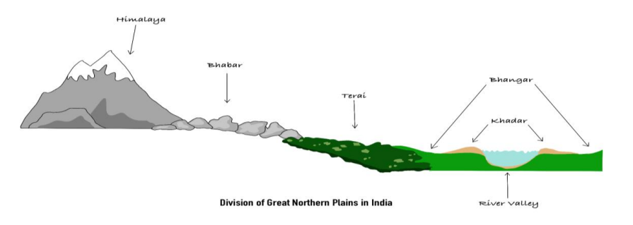
1. The North-to-South Journey
Imagine you are walking from the top of the Himalayas down to the plains. You will cross four different types of land in a specific order.
2. Bhabar (The Porous Rock Bed)
Location: This is the first belt lying immediately at the foot of the Himalayas (Shiwaliks).
What is it? It is a narrow belt (8-10 km wide) of heavy rocks and pebbles that rivers dump as soon as they leave the steep mountains.
Key Feature (The Magic Trick): Because it is made of loose rocks, it is very porous (like a sieve). Small rivers and streams disappear underground here. You can hear the water flowing underneath, but the surface looks dry!
Agriculture: Not suitable for crops because water sinks down. Only big trees with long roots grow here.
3. Tarai (The Wet Swamp)
Location: South of the Bhabar belt.
What is it? The water that disappeared in Bhabar re-emerges (comes back to the surface) here.
Key Feature: Because the water comes back up without a proper channel, this area becomes wet, swampy, and marshy.
Ecology: Historically, this was a thick forest filled with mosquitoes and wildlife. Now, much of it has been cleared for farming (Sugarcane/Rice), especially in UP and Punjab.
4. Bhangar (The Old Alluvium)
Location: This forms the largest part of the Northern Plains.
What is it? This is Older Soil deposited by rivers ages ago. It lies above the current flood level of rivers (High Ground).
Key Feature:
- It is like a terrace or a platform that floods usually don't reach.
- It contains calcium deposits (calcareous nodules) locally called 'Kankar'.
Agriculture: It is fertile but not as fertile as Khadar.
5. Khadar (The New Alluvium)
Location: The lowest land right next to the river banks.
What is it? This is New Soil deposited by floods almost every year.
Key Feature:
- It is the most fertile land because the soil is renewed annually.
- It creates the 'Floodplains'.
Agriculture: Best for intensive agriculture (growing crops year after year).
| Division | Features |
|---|---|
| Bhabar | 8–10 km belt of coarse sediments; porous; rivers disappear; dry beds; unsuitable for farming |
| Tarai | South of Bhabar; swampy; marshy; re-emerging streams; fertile but unhealthy |
| Bhangar | Old alluvium; terraces; dark, clayey, humus-rich; has kankar; found in doabs |
| Khadar | New alluvium; floodplains; sandy, porous, fertile; renewed annually |
Prelims tips
- Bhabar → porous belt, rivers disappear underground.
- Tarai → swampy belt south of Bhabar; re-emergence of rivers.
- Bhangar → old alluvium, terraces, kankar nodules.
- Khadar → new alluvium, fertile, floodplains (renewed annually).
- Punjab’s Khadar floodplains = ‘Bets’.
- Saline patches in Bhangar = Reh/Kallar/Bhur.
Mains points
- The Northern Plains show distinct physiographic zones: Bhabar (porous belt), Tarai (marshy belt), Bhangar (old alluvium), Khadar (new alluvium).
- Bhabar and Tarai represent drainage features; Bhangar and Khadar represent depositional features.
- Khadar is agriculturally most important due to annual renewal of fertile soil.
- Bhangar has local variations like Barind (Bengal), Bhur (Doab), and saline patches (Reh/Kallar).
The Great Indian Desert (Thar Desert)
The Thar Desert is a unique landscape in North-West India and the world's 9th largest desert. Although it looks like a flat plain, geologically, it is actually an extension of the Peninsular Plateau that has been covered by sand over millions of years.
1. Location and Origin (Where & Why?)
Location: It lies mostly in Western Rajasthan, extending into Gujarat, Punjab, and Haryana. To its East lie the Aravalli Mountains.
Why is it a desert?
The Aravalli hills run parallel to the rain-bearing monsoon winds. Imagine a wall standing sideways; it doesn't block anything. Similarly, the Aravallis don't block the winds, so the clouds pass by without dropping rain, leaving this area dry.
Geological Surprise: Millions of years ago (Mesozoic era), this entire desert was under the sea. We know this because scientists have found marine fossils and wood fossils (in Aakal Wood Fossil Park) here.
2. Two Main Zones of the Desert
The desert is broadly divided into two parts based on how dry they are:
A. Marusthali (The Dead Land)
What is it? This is the 'real', harsh desert in the West.
Features:
- It has very little vegetation (cactus, thorny bushes).
- It is covered with shifting sand dunes.
- Barchans: These are crescent-shaped (moon-shaped) sand dunes that move with the wind. They are a common sight here.
B. Rajasthan Bagar (The Semi-Desert)
What is it? This is the transition zone between the dry desert in the West and the green Aravalli mountains in the East.
Features:
- It is not completely dry. It has a thin layer of sand but supports some grass and farming.
- It serves as a buffer zone protecting the rest of India from the desert sands.
3. Water Features (Rivers & Lakes)
A. The Luni River (The Lifeline):
- This is the only major river in this region.
- Source: It starts from the Pushkar Valley (Aravallis).
- End: It does not reach the sea. It disappears into the marshy lands of the Rann of Kutch (Gujarat).
B. Inland Drainage:
- Most small streams here flow for a short distance and then get lost in the sand or drain into salt lakes. They never reach the ocean. This process is called 'Inland Drainage'.
C. Salt Lakes (Playas):
- The region has many saltwater lakes like Sambhar (India's largest inland salt lake), Didwana, and Kuchaman.
- Why Salty? Because the water evaporates quickly due to extreme heat, leaving salt deposits behind.
4. Important Local Terms
- Rohi: The fertile green patches of land found along the river banks in the desert. These are good for agriculture.
- Thali: The sandy plain area located to the North of the Luni river.
- Dhand: Alkaline (salty) lakes found in the depressions (low points) between sand dunes.
- Dhrians: The local name for shifting sand dunes that move with the wind.
| Aspect | Details |
|---|---|
| Extent | NW Aravallis to Cholistan Desert (Pakistan) |
| Local Name | Marusthali (‘Dead Land’) |
| Semi-desert Region | Bagar (thin sand cover, seasonal streams, salt lakes) |
| Fertile Patches | Rohi (cultivable spots) |
| River | Luni – seasonal, from Pushkar valley |
| Inland Drainage | Streams → playas/lakes (Sambhar, Didwana, etc.) |
| Landforms | Sand dunes, barchans, mushroom rocks, oases |
| Geology | Once under sea; uplift during Pleistocene |
Prelims tips
- Thar = world’s 9th largest desert; locally called Marusthali.
- Bagar = semi-desert west of Aravallis; drained by Luni; has salt lakes.
- Rohi = fertile patches in Thar.
- Luni = seasonal river; flows into Rann of Kutch.
- Sambhar Lake = largest inland salt lake in India.
- Desert once submerged under sea (Permo-Carboniferous).
Mains points
- The Thar Desert represents an arid landscape shaped by aridity, shifting dunes, saline lakes, and seasonal streams.
- It plays a role in salt production (Sambhar, Didwana) and sustains pockets of agriculture in Rohi and Bagar regions.
- River Luni is the most significant seasonal stream, highlighting desert hydrology.
- Geological history shows the Thar was once a seabed, uplifted during the Pleistocene, making it a unique physiographic unit.
The Peninsular Plateau of India (The Ancient Tableland)
The Peninsular Plateau is the oldest and most stable part of India. Imagine a huge, triangular-shaped table made of hard rocks. It was formed when the ancient Gondwana land broke apart millions of years ago. It is rich in minerals like Coal and Iron, making it the industrial heart of India.
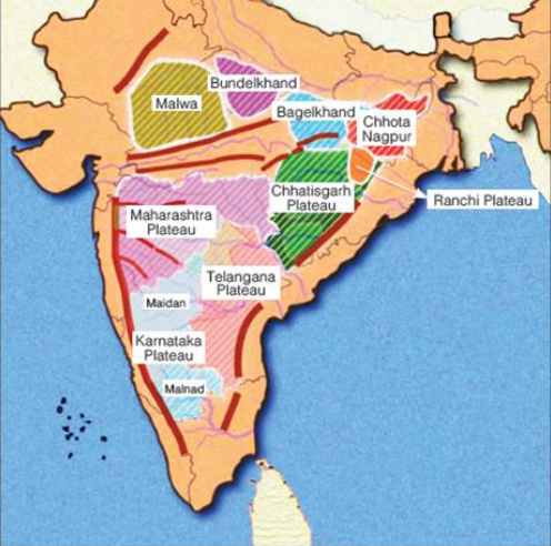
1. What is a 'Plateau'?
A plateau is a flat-topped highland, like a table standing above the surrounding area.
The Indian Context: The Peninsular Plateau rises 600-900 meters above sea level and covers the southern part of India.
2. Location and Extent (Where is it?)
Shape: It is roughly triangular, with the base in the North and the tip in the South (Kanyakumari).
Boundaries:
- North: Delhi-Aravalli Ridge and Rajmahal Hills.
- West: Gir Range (Gujarat) and Western Ghats.
- East: Eastern Ghats.
- South: Cardamom Hills.
Surprise Extension: Even the Shillong Plateau (Meghalaya) in the North-East is actually a broken piece of this same Peninsular Plateau!
3. How was it formed? (The History)
Origin: It was once part of the supercontinent Gondwanaland. When India split and moved northwards, this block remained solid and stable.
Composition: It is made of very old, hard crystalline rocks (Igneous and Metamorphic) like Granite and Gneiss. This makes it stable and earthquake-resistant (mostly).
4. Unique Features of the Plateau
A. Rift Valleys (Cracks in the Earth):
- While most rivers flow East, the Narmada and Tapti rivers flow West. Why?
- Because they flow through deep cracks in the earth called 'Rift Valleys' created during the Himalayan uplift.
B. Ravines (Badlands):
- In the Chambal valley (MP/Rajasthan), the river has cut deep, maze-like gullies into the land. These are called Ravines (famous hideouts for dacoits in movies!).
C. The Garo-Rajmahal Gap:
- A long time ago, a fault (crack) separated the Meghalaya Plateau from the main Indian Plateau. This gap was later filled with mud by the Ganga and Brahmaputra rivers. Today, it separates West Bengal from Meghalaya.
5. Why is it economically important?
This region is the Storehouse of Minerals.
- 98% of India's Coal is found here (Gondwana coal).
- It is rich in Iron ore, Manganese, Bauxite, Copper, and Gold.
- Most of India's heavy industries (Steel plants, Power plants) are located here.
| Feature | Description | Significance |
|---|---|---|
| Age | Oldest part of India. | Very stable landmass. |
| Shape | Inverted Triangle. | Determines India's coastline. |
| Rocks | Igneous & Metamorphic. | Rich in metallic minerals. |
| Rivers | Narmada, Tapti, Godavari. | Irrigation & Hydropower. |
| Extensions | Shillong Plateau (NE India). | Tea cultivation & coal. |
Prelims tips
- The Gap: The 'Malda Gap' or 'Garo-Rajmahal Gap' separates the main plateau from the Meghalaya plateau.
- West Flowing: Narmada and Tapti are the only major peninsular rivers flowing West because of Rift Valleys.
- Tors: These are mushroom-shaped granite rocks found on the plateau due to weathering.
- Minerals: Gondwana rocks = Coal. Dharwar rocks = Metals (Iron/Gold).
Mains points
- Industrial Backbone: Explain how the Chotanagpur Plateau (part of this region) became the hub of India's steel and heavy industries due to iron and coal proximity.
- Water Crisis: Unlike Himalayan rivers, Peninsular rivers are rain-fed (seasonal). Discuss the water scarcity issues in states like Maharashtra and Karnataka.
- Agriculture: The black soil (Deccan Trap) found here is perfect for Cotton cultivation.
Plateaus of Peninsular India
The Peninsular Plateau is divided into the Central Highlands, the Deccan Plateau, and the North-Eastern Plateau. Each region has unique physiography, elevation, geology, and resource distribution, making it the mineral and agricultural heart of India.
1. The Central Highlands (The Northern Part)
Location: Lies North of the Narmada River and South of the Great Northern Plains. This region forms the older part of the Peninsular Block.
Geology: Composed mainly of ancient igneous and metamorphic rocks (Granite & Gneiss) belonging to the Archean age.
Slope: General slope is from South-West to North-East, which guides river flow patterns. Hence, rivers like Chambal, Betwa, and Ken flow towards the Yamuna.
Climate: Semi-arid to sub-humid climate; rainfall decreases westwards.
Economic Use: Known for livestock rearing, millet farming, and mining (limestone, sandstone).
Sub-Divisions:
A. Marwar Upland (Rajasthan):
- Location: Lies to the East of the Aravalli Range.
- Formation: Formed by river erosion and deposition of the Luni and Banas river systems.
- Soil: Sandy-loam soil with low fertility.
- Significance: Acts as a transitional zone between the Thar Desert and the Peninsular Highlands.
B. Malwa Plateau (Madhya Pradesh):
- Formation: Built by extensive volcanic eruptions → Basaltic deposits.
- Soil: Black cotton soil (Regur) ideal for Cotton, Soybean, and Pulses.
- Drainage: Drained by the Chambal, Kali Sindh, and Mahi rivers.
- Economic Importance: Important for agriculture and urban centres like Indore, Ujjain.
C. Bundelkhand Plateau (UP & MP):
- Characteristics: Rugged, rocky terrain made of ancient granite and gneiss.
- Relief: Deep ravines (badlands) formed due to gully erosion by Chambal & Ken rivers.
- Challenges: Drought-prone region due to poor soil moisture and low rainfall.
- Economy: Known for pulses, oilseeds, and emerging as a region for Bundelkhand Expressway.
D. Chhotanagpur Plateau (The Mineral Heart):
- Location: Spread across Jharkhand, Chhattisgarh, Odisha, and West Bengal.
- Geology: Rich in Gondwana coal deposits and metallic minerals.
- Mineral Wealth: Coal, Iron ore, Bauxite, Manganese, Uranium – hence called the 'Ruhr of India'.
- Industrial Importance: Hosts major industries: Jamshedpur (Steel), Bokaro (Steel), Dhanbad (Coal).
- Patlands: Table-like flat uplands formed by long-term erosion.
2. The Deccan Plateau (The Southern Triangle)
Location: Triangular landmass South of the Narmada River.
Geological Formation: Result of massive volcanic eruptions during the Cretaceous period.
Deccan Trap: Staircase-like structure formed by layered lava flows; covers Maharashtra, parts of MP and Gujarat.
Soils: Dominated by Black (Regur) soil, ideal for cotton.
Drainage: Rivers flow Eastwards (Godavari, Krishna, Kaveri) due to slope towards the Bay of Bengal.
Sub-Divisions:
A. Maharashtra Plateau:
- Entirely made of Basalt rocks of the Deccan Traps.
- Agriculture: Cotton, Sugarcane, Soybean.
- Drainage: Godavari and Krishna tributaries pass through.
B. Karnataka Plateau (Mysore Plateau):
- Malnad: Western, hilly region with dense forests and heavy rainfall.
- Maidan: Eastern, undulating plains suitable for cultivation.
- Rivers: Kaveri, Tungabhadra, and Sharavati originate here.
- Shravana Belgola, Mysuru – significant cultural sites.
C. Telangana Plateau:
- One of the oldest parts of the Indian landmass (Archean Gneiss).
- Agriculture: Groundnut, Millets, Cotton.
- Drainage: Godavari, Krishna, Manjira rivers.
- Minerals: Rich in coal (Singareni), limestone, granite.
3. The North-Eastern Plateau (The Separated Sibling)
Geological Fact: Once part of the Peninsular Plateau but separated due to faulting.
Garo-Rajmahal Gap: A major tectonic fault filled by alluvial deposits of Ganga & Brahmaputra.
Rock Type: Granite and Gneiss, similar to the Peninsular region.
Climate: One of the wettest regions on Earth.
Important Peaks: Shillong Peak (highest in Meghalaya).
Key Features:
- Comprises Garo, Khasi, and Jaintia hills.
- Famous sites: Cherrapunji, Mawsynram (world’s highest rainfall).
- Contains important passes and river gorges.
- Known for Pineapple, Lakadong Turmeric, Oranges, and Limestone deposits.
| Plateau | Location / Features |
|---|---|
| Central Highlands | North of Narmada; Marwar, Malwa, Bundelkhand, Chhotanagpur |
| Marwar Upland | East of Aravallis; 250–500 m; rolling plains; Chambal & Banas erosion |
| Malwa Plateau | MP; basaltic lava, black soil; cotton cultivation |
| Bundelkhand Plateau | UP–MP; dissected upland; granite & sandstone; semi-arid |
| Chhotanagpur Plateau | Jharkhand–Chhattisgarh–WB; mineral rich; Patland (‘Ruhr of India’) |
| Deccan Plateau | South of Narmada; volcanic trap structure; Maharashtra, Karnataka, Telangana sub-plateaus |
| Maharashtra Plateau | Basaltic lava; regur soil; Godavari & Krishna valleys |
| Karnataka Plateau | Mysore Plateau; Malnad (hilly) & Maidan (plain) |
| Telangana Plateau | Archaean gneiss; peneplains + ghats; drained by Godavari, Krishna, Penneru |
| North-Eastern Plateau | Meghalaya/Shillong; Garo, Khasi, Jaintia, Mikir hills; heavy rainfall, eroded |
Prelims tips
- Central Highlands: north of Narmada; includes Malwa, Bundelkhand, Chhotanagpur.
- Marwar Upland = east of Aravallis, rolling plain.
- Malwa = basaltic lava, black soil (cotton).
- Chhotanagpur = mineral-rich, Patland = ‘Ruhr of India’.
- Deccan Plateau = volcanic trap, black cotton soil, rivers west→east.
- Karnataka Plateau = Malnad (hilly, forests) + Maidan (plain).
- NE Plateau = Shillong Peak highest; heavy rainfall, erosion.
Mains points
- The Peninsular Plateaus show diversity: Central Highlands (erosional, old rocks), Deccan Plateau (volcanic), NE Plateau (rainfall-eroded).
- Chhotanagpur Plateau’s mineral wealth sustains India’s mining industry.
- Deccan Plateau’s black soils & rivers enable cotton agriculture & hydropower.
- NE Plateau (Meghalaya) receives highest rainfall, leading to erosion & unique ecology.
- The physiography influences agriculture, resource distribution, settlement patterns & industrialization.
Coastal Plains of India
The Coastal Plains are not just borders; they are the economic gateways of India. Geologically, the Western Coast is a 'Submerged Coast' (good for ports), while the Eastern Coast is an 'Emergent Coast' (good for deltas).

1. Introduction (परिचय)
Imagine India as a 'V' shape. The flat lands running along the edges of this 'V' (between the sea and the mountains) are the Coastal Plains. They stretch for about 7,516 km, covering 9 states and 4 Union Territories.
2. Western Coastal Plains (पश्चिमी तटीय मैदान)
Location: These are narrow strips of land sandwiched between the Western Ghats and the Arabian Sea.
Key Feature - Submerged Coast: This land has 'sunk' slightly into the sea. Because of this sinking, the sea water is very deep right next to the land. This makes it perfect for natural ports (like Mumbai) because big ships can come close to the shore without getting stuck.
Regional Divisions:
- Kutch & Kathiawar (Gujarat): The northernmost part. Includes the famous salt desert 'Rann of Kutch'.
- Konkan Coast (Maharashtra & Goa): A rocky and uneven coastline.
- Kannada Coast (Karnataka): Known for iron deposits and swift rivers.
- Malabar Coast (Kerala): The most famous part. It has 'Kayals' (Backwaters/Lagoons) which are lakes running parallel to the sea. The famous Nehru Trophy Boat Race happens here.
3. Eastern Coastal Plains (पूर्वी तटीय मैदान)
Location: These are wide strips of land between the Eastern Ghats and the Bay of Bengal.
Key Feature - Emergent Coast: Here, the land has either risen up or rivers have dumped so much mud (silt) that the sea floor is shallow. Because the water is shallow, big ships cannot come close to the shore easily. Hence, ports here are often artificial (man-made).
Regional Divisions:
- Northern Circars: The northern half (Odisha & West Bengal).
- Coromandel Coast: The southern half (Andhra Pradesh & Tamil Nadu). This coast is unique because it gets rain in Winter (from North-East Monsoon).
4. Estuaries vs. Deltas (ज्वारनदमुख बनाम डेल्टा)
West Flowing Rivers (Narmada, Tapi): They flow fast through hard rocks. They don't carry much mud. When they meet the sea, they form an open mouth called an Estuary.
East Flowing Rivers (Godavari, Krishna): They flow slowly over long distances carrying huge amounts of mud/sand. When they reach the sea, they pile up this mud forming a triangle shape called a Delta.
| Feature | Western Coastal Plain | Eastern Coastal Plain |
|---|---|---|
| Width (चौड़ाई) | Narrow (avg 65 km). Sandwiched tight. | Broad/Wide (avg 120 km). Plenty of space. |
| River Feature (नदी विशेषता) | Forms Estuaries (Clean mouth). Example: Narmada, Tapi. | Forms Deltas (Muddy buildup). Example: Mahanadi, Godavari, Krishna. |
| Ports (बंदरगाह) | Natural Ports (Mumbai, Marmagao, Cochin). Deep water helps. | Mostly Artificial Ports (Chennai, Paradip). Shallow water requires dredging. |
| Rainfall (वर्षा) | High rainfall from SW Monsoon (June-Sept). | Receives rain from SW Monsoon (North) & NE Monsoon/Winter (South). |
| Soil (मिट्टी) | Mostly Laterite (leached soil). | Alluvial (very fertile delta soil). |
| Rank | State/UT | Length (approx) |
|---|---|---|
| 1 | Andaman & Nicobar Islands (UT) | 1,962 km |
| 2 | Gujarat (State Rank 1) | 1,215 km |
| 3 | Andhra Pradesh | 974 km |
| 4 | Tamil Nadu | 906 km |
| 5 | Maharashtra | 652 km |
Prelims tips
- Ranking Trap: If the question asks 'Which State/UT has the longest coastline?', the answer is Andaman & Nicobar. If it specifically asks for a 'State', then the answer is Gujarat.
- Evidence of Submergence: The ancient city of Dwarka (Gujarat) is believed to have been submerged under the sea, which proves the western coast is a sinking land.
- Chilika Lake: Located in the Eastern Plain (Odisha), it is the largest brackish water (salty) lagoon in India.
- Granary of South India: The deltas of Krishna and Godavari on the East Coast are called this because they produce a huge amount of Rice.
Mains points
- Strategic Significance: The Western Coast allows easy access to the Suez Canal route and oil-rich nations (Middle East), which is vital for India's energy security.
- Economic Value: The Eastern Coast is famous for Rice cultivation (Deltas), while the Western Coast is famous for Plantation crops (Spices, Coconut, Rubber).
- Climate Vulnerability: The Eastern Coast is highly prone to Cyclones originating in the Bay of Bengal (e.g., Fani, Amphan), requiring strong disaster management systems.
- Blue Economy: These plains act as the base for deep-sea fishing, offshore oil mining (like Bombay High), and the 'Sagarmala' port development project.
Andaman & Nicobar Islands
The Andaman & Nicobar Islands are a long chain of 572 islands (Archipelago) in the Bay of Bengal. Geologically, they are the peaks of a submerged mountain range connecting Myanmar to Indonesia. They are strategically vital as they dominate the entrance to the Malacca Strait.
1. Geography & Origin (भूगोल और उत्पत्ति)
What are they? Imagine a mountain range like the Himalayas walking into the ocean. The mountains go underwater, and only their highest peaks poke out of the water. These 'peaks' are the Andaman & Nicobar Islands. They are an extension of the Arakan Yoma range in Myanmar.
The Layout (North to South): The islands are not one lump of land. They are divided into two distinct groups separated by a wide stretch of water called the 10 Degree Channel.
- Andaman Group (North): Includes North Andaman, Middle Andaman (Largest), South Andaman (Capital Port Blair is here), and Little Andaman.
- Nicobar Group (South): Includes Car Nicobar, Little Nicobar, and Great Nicobar (Southernmost).
2. Key Channels & Passages (महत्वपूर्ण चैनल और मार्ग)
In geography, a 'Channel' or 'Passage' is a water body that separates two landmasses. Matching these correctly is a favorite UPSC question.
- Coco Channel: Separates North Andaman from Myanmar's Coco Islands (China has a surveillance base here).
- Duncan Passage: Separates South Andaman form Little Andaman.
- 10 Degree Channel: The big divider between the Andaman group and the Nicobar group.
- Great Channel (6 Degree Channel): Separates Great Nicobar from Sumatra (Indonesia). This is an international trade route.
3. Volcanoes and Peaks (ज्वालामुखी और चोटियाँ)
Barren Island: It is India's only active volcano. It is located to the east of Middle Andaman. It last erupted in 2017.
Narcondam Island: An extinct volcano (has not erupted in thousands of years).
Saddle Peak (732m): The highest mountain in the islands, located in North Andaman.
4. Indigenous Tribes (आदिवासी जनजातियाँ)
The islands are home to some of the most isolated tribes in the world (PVTGs). They are protected by law, and outsiders cannot enter their areas.
- Negrito Stock (Black skin, curly hair): Found in Andaman group. Includes Jarawas, Great Andamanese, Onge, and the hostile Sentinelese (North Sentinel Island).
- Mongoloid Stock (Lighter skin, straight hair): Found in Nicobar group. Includes Shompen (shy, isolated) and Nicobarese (integrated with modern society).
| Channel / Passage | Separates What? | Importance |
|---|---|---|
| Coco Channel | North Andaman AND Coco Islands (Myanmar) | Strategic boundary; China fears. |
| Duncan Passage | South Andaman AND Little Andaman | Separates the capital (Port Blair) from the southern island. |
| 10 Degree Channel | Little Andaman AND Car Nicobar | The main boundary between Andaman & Nicobar groups. |
| Sombrero Channel | Car Nicobar AND Little Nicobar | Divides the Nicobar group internally. |
| Great Channel | Great Nicobar AND Sumatra (Indonesia) | Closest point to Indonesia; vital for international shipping. |
Prelims tips
- Capital Trap: Port Blair is in South Andaman. Questions often confuse it with Middle/North Andaman.
- The Sinking Point: Indira Point (Great Nicobar) is the southernmost point of India. It subsided (sank) by 4.25 meters during the 2004 Tsunami.
- Barren Island: It is the only active volcano in South Asia. Narcondam is dormant/extinct.
- State Animal: The Dugong (Sea Cow) is the state animal of A&N islands.
- Distance Fact: The islands are closer to Indonesia (approx 150 km) and Myanmar than to the Indian mainland (Chennai is ~1200 km away).
Mains points
- Strategic Significance (Necklace of Diamonds): India is developing these islands to counter China's 'String of Pearls'. The Tri-Service Command (Army, Navy, Air Force together) is stationed here.
- Great Nicobar Development Project: A massive ₹72,000 crore project is planned here for a Trans-shipment Port, Airport, and Power Plant.
Concerns: Destruction of rainforests, threat to the rare Leatherback Turtle nesting sites at Galathea Bay, and displacement of Shompen tribes. - Disaster Management: Located in Seismic Zone V, the islands are highly vulnerable to earthquakes and tsunamis (like in 2004).
Lakshadweep and Minicoy Islands & Other Important Islands
Lakshadweep is India's 'Coral Paradise' in the Arabian Sea. Unlike the rocky and mountainous Andaman islands, these islands are flat and made entirely of corals. Apart from these, India has several strategic islands near the coast like Sriharikota (Space Port) and Majuli (River Island).
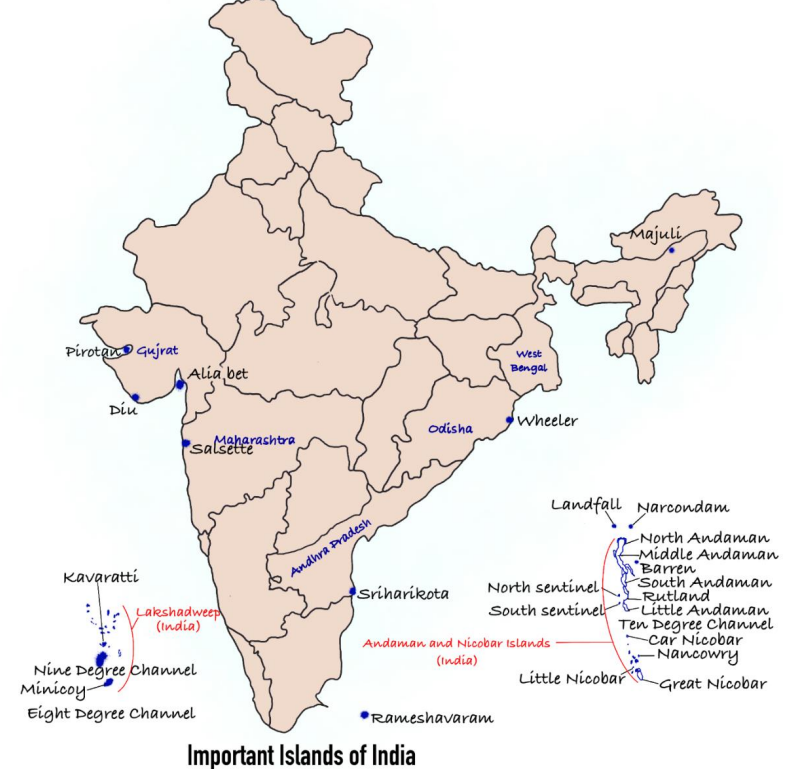
1. Lakshadweep Group (लक्षद्वीप समूह)
What are they? These are Coral Atolls. Imagine millions of tiny sea creatures called 'Polyps' dying over thousands of years. Their skeletons pile up to form hard rock-like structures called Corals. When these corals form a ring shape with a lake (lagoon) in the middle, it is called an Atoll. Lakshadweep is a collection of such Atolls.
Geography: It is the smallest Union Territory of India. It consists of three main subgroups:
- Amindivi Islands: The northernmost group.
- Laccadive Islands: The middle group (where the capital Kavaratti is located).
- Minicoy Island: The southernmost and largest individual island. It is culturally closer to the Maldives (people speak Mahal language).
2. Important Channels (महत्वपूर्ण चैनल)
These are water bodies that separate the islands. You must remember these for exams:
- 11 Degree Channel: Separates Amindivi (North) from Laccadive (South).
- 9 Degree Channel: Separates the main Lakshadweep group from Minicoy Island.
- 8 Degree Channel: Separates Minicoy Island from the country of Maldives.
3. Other Strategically Important Islands (अन्य रणनीतिक रूप से महत्वपूर्ण द्वीप)
Sriharikota (Andhra Pradesh): Located near Chennai. It is a Barrier Island separating Pulicat Lake from the Bay of Bengal. It is famous because India launches all its rockets (Chandrayaan, Mangalyaan) from the Satish Dhawan Space Centre here.
Wheeler Island (Odisha): Now called Dr. Abdul Kalam Island. It is a military facility used exclusively for testing missiles (like Agni and Prithvi). Civilians are not allowed here.
Majuli (Assam): Situated in the middle of the mighty Brahmaputra river. It is the world's largest river island. It is the cultural capital of Assam (famous for Satriya dance and monasteries).
Salsette Island (Maharashtra): Most people don't realize this, but the mega-city of Mumbai is built on this island. It is separated from the mainland by Thane Creek.
Pamban Island (Tamil Nadu): Also known as Rameswaram Island. It forms the first link of the Ram Setu (Adam's Bridge) connecting India to Sri Lanka.
| Island | Key Feature |
|---|---|
| Lakshadweep | Coral islands; 36 total, 11 inhabited; Minicoy is largest. |
| Majuli (Assam) | World’s largest freshwater island; first island district. |
| Salsette (Maharashtra) | Mumbai city located here. |
| Sriharikota (AP) | Barrier island; ISRO satellite launch site. |
| Aliabet (Gujarat) | First offshore oil well site of India. |
| Wheeler Island (Odisha) | Missile testing station (Abdul Kalam Island). |
| Pirotan (Gujarat) | Marine National Park islands; mangroves present. |
| Diu (Gujarat) | South of Kathiawar Peninsula. |
| Rameshwaram (TN) | Near Sri Lanka; linked by Pamban Bridge. |
| Hope Island (AP) | Tadpole-shaped island in Bay of Bengal. |
Prelims tips
- Lakshadweep = smallest UT; entirely coral origin.
- Minicoy = largest island; south of Nine Degree Channel.
- Majuli (Assam) = world’s largest freshwater island.
- Sriharikota = ISRO launch site (AP).
- Rameshwaram = linked to mainland by Pamban Bridge.
Mains points
- Lakshadweep islands are ecologically fragile (coral reefs, lagoons) and vulnerable to sea-level rise.
- They are strategically important in the Arabian Sea for India’s naval and trade routes.
- Other islands like Sriharikota and Wheeler are vital for space and defense programs.
- Majuli highlights India’s unique riverine island ecosystem and cultural heritage.
- Rameshwaram and Diu are culturally and historically significant coastal islands.
Indian Climate – Features of Monsoon
The Monsoon is not just rain; it is a 'Seasonal Reversal of Winds'. Imagine a giant sea breeze that blows from sea to land in summer (bringing rain) and land to sea in winter (bringing dry weather). It is the lifeline of the Indian economy.
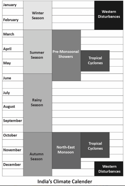
1. What is 'Monsoon'?
The word comes from the Arabic word 'Mausim', meaning season. In geography, it specifically refers to a unique climate type where the wind direction completely reverses every six months.
The Pendulum Analogy: Think of the wind like a pendulum. In Summer, it swings from the Sea towards the Land (bringing moisture and rain). In Winter, it swings back from the Land towards the Sea (bringing dry, cold air).
2. The Mechanism: Why does it happen?
For a beginner, understanding the 'Why' is crucial. It happens due to a combination of three main factors:
A. Differential Heating (The Vacuum Cleaner Effect):
In summer, the land gets very hot, much faster than the ocean. Hot air rises, creating a Low Pressure zone over India. The ocean remains cool (High Pressure). Nature hates a vacuum, so wind rushes from the High Pressure ocean to fill the Low Pressure void on land. These winds carry water, causing rain.
B. Shifting of ITCZ (The Rain Magnet):
The Inter-Tropical Convergence Zone (ITCZ) is a belt of low pressure near the equator where the sun shines brightest. It acts like a magnet for winds. In summer, as the Sun moves north, this 'Rain Magnet' shifts northwards over the Ganga plains, pulling the moisture-laden winds from the ocean up into India.
C. Coriolis Force (The Steering Wheel):
Once the winds cross the equator to rush towards India, the rotation of the Earth (Coriolis Force) twists them to the right. This makes them blow from the South-West direction. That is why it is called the 'South-West Monsoon'.
3. Unique Characteristics of Indian Rainfall
1. Pulsating Nature (The Burst):
The monsoon doesn't arrive slowly like a drizzle. It often starts with a sudden, violent thunderstorm. This dramatic start is called the 'Burst of Monsoon' (usually hitting Kerala on June 1st).
2. Orographic Rain (The Mountain Wall):
The mountains decide who gets rain. When the monsoon winds hit the Western Ghats, they are forced to rise and cool down, dropping all their rain on the coast (Mumbai). By the time they cross to the other side (Pune), they are empty. This dry side is called the Rain Shadow Region.
3. Uneven Distribution:
Rainfall is not fair. Mawsynram (Meghalaya) gets over 1000 cm of rain because the hills there (Garo, Khasi, Jaintia) are shaped like a funnel, trapping the clouds. In contrast, Jaisalmer (Rajasthan) gets less than 10 cm because the Aravalli hills run parallel to the wind and don't stop it.
4. Important Phases
The Break in Monsoon:
It does not rain continuously for 4 months. There are dry spells (days without rain) in between July and August. This is called a 'Break'. It usually happens when the rain-bearing belt shifts towards the Himalayas.
The Retreat (The Return Journey):
By October, the land cools down, and the low pressure disappears. The winds start withdrawing (going back) from India. This is called the Retreating Monsoon. Unlike the summer rain, this withdrawal is gradual.
| Feature | South-West Monsoon (The Giver) | North-East Monsoon (The Retreat) |
|---|---|---|
| Season | Summer (June to September) | Winter (October to December) |
| Direction | Blows from Sea to Land (Wet Winds) | Blows from Land to Sea (Dry Winds) |
| Rainfall Source | Arabian Sea Branch & Bay of Bengal Branch | It is dry initially but picks up moisture from the Bay of Bengal while crossing it. |
| Who Benefits? | Whole of India (75% of total annual rain) | Primarily Tamil Nadu and Coastal Andhra Pradesh |
Prelims tips
- Retreating Monsoon Anomaly: While the rest of India is dry in winter, Tamil Nadu (Coromandel Coast) receives floods/rain. This is due to the North-East Monsoon picking up moisture from the sea.
- Two Branches: The SW Monsoon hits India in two branches. The Arabian Sea branch is much stronger (3 times) than the Bay of Bengal branch.
- El Nino vs La Nina:
- El Nino (warming of Pacific Ocean) usually means a Weak Monsoon (Droughts).
- La Nina (cooling of Pacific Ocean) usually means a Strong Monsoon (Floods). - Date of Onset: Traditionally, the monsoon hits the Kerala coast on June 1st. However, it reaches the Andaman & Nicobar Islands earlier (around May 20-25).
Mains points
- Impact on Agriculture: 55% of India's net sown area is rain-fed. A good monsoon lowers food inflation and boosts rural income (demand for tractors, FMCG goods increases).
- Cultural Significance: The monsoon rhythm defines the Indian calendar. Festivals like Onam (arrival of rain/harvest), Teej, and Ganesh Chaturthi are closely linked to the rainy season.
- Climate Change Threat: We are observing a trend of 'Extreme Weather Events'—short periods of very heavy rain leading to flash floods (e.g., in Himachal, Uttarakhand) followed by long dry spells, which is bad for crops.
Salient Features of Indian Climate
India's climate is a land of extremes but united by the Monsoon. It is defined by the 'Unity in Diversity' principle—while the whole country has a Tropical Monsoon climate, local conditions vary wildly from freezing Leh to scorching Rajasthan.
1. Seasonal Reversal of Winds (The Monsoon Pulse)
The most distinct feature of Indian climate is that the wind changes direction completely twice a year. Think of it like a pendulum swinging back and forth.
Summer (South-West Monsoon): From June to September, winds blow from the Sea towards the Land. Since they come from the ocean, they are full of moisture and bring heavy rain to the entire country.
Winter (North-East Monsoon): From October to December, winds blow from the Land towards the Sea. Since they come from the land (Himalayas/Siberia), they are dry and bring cold weather.
2. Formation of Pressure Zones (The Engine)
Wind always flows from High Pressure (Cool area) to Low Pressure (Hot area). India acts like a giant thermal engine.
Summer Mechanism: The Sun shines brightly over North India, heating the land immensely. Hot air rises, creating a Low Pressure vacuum. The Indian Ocean remains cool (High Pressure). Nature rushes to fill this vacuum, causing winds to rush from the ocean to the land.
Winter Mechanism: The land cools down rapidly, creating High Pressure. The ocean remains warmer (Low Pressure). So, winds blow outwards from India to the ocean.
3. Rainfall: The '4-Month' Phenomenon
In many Western countries, it rains a little bit throughout the year. In India, rainfall is highly concentrated.
Concentration: India receives about 80% to 90% of its total annual rainfall in just 4 months (June, July, August, September).
Consequence: This makes water management very difficult. We have floods during these 4 months and water scarcity during the rest of the year. This is why dams and tanks are crucial in India.
4. Unity of Indian Climate (The Himalayan Wall)
Despite being a large country, the whole of India is climatically 'United'. This is largely due to the Himalayas.
Protection from Cold: The Himalayas stand like a tall wall in the North. They block the freezing cold winds from Central Asia and Siberia. Without them, North India would be a freezing cold desert like the Gobi Desert. Because of this wall, even North India remains warm enough for agriculture.
Trapping the Rain: The Himalayas also stop the moisture-laden Monsoon winds from escaping into Tibet, forcing them to shed their rain within India.
5. Diversity of Indian Climate (Local Extremes)
While the general climate is 'Monsoon', the local experience varies drastically depending on where you are.
Temperature Extremes: In Summer, places like Churu (Rajasthan) can touch 55°C, while in Winter, Drass (Ladakh) can drop to -45°C.
Rainfall Extremes: Mawsynram (Meghalaya) receives over 1000 cm of rain (wettest place on Earth), while Jaisalmer (Rajasthan) receives less than 10 cm (drier than some deserts).
Coast vs Interior: Places near the sea (Mumbai, Chennai) have a 'Moderate Climate' (neither too hot nor too cold). Places far from the sea (Delhi, Punjab) have an 'Extreme Climate' (Very hot summers, very cold winters). This is called Continentality.
6. Natural Calamities
The Indian climate is often described as 'Moody'. It is prone to natural disasters.
Floods: Occur when the monsoon is too strong (common in Assam, Bihar).
Droughts: Occur when the monsoon fails or comes late (common in Vidarbha, Rayalaseema).
Cyclones: Occur mostly during the transition months (October-November) and affect the Eastern Coast (Odisha, Andhra Pradesh).
| Feature | Description |
|---|---|
| Wind Reversal | NE trade winds in winter; SW monsoon winds in summer |
| Pressure Zones | Seasonal high-low pressure shifts over land & ocean |
| Rainfall | 80% annual rainfall in 4 months (SW monsoon) |
| Seasons | Broadly five; main three – Summer, Winter, Monsoon |
| Unity | Overall tropical; Himalayas shield from cold winds |
| Diversity | Temp: -45°C (Leh) to 55°C (Rajasthan); varied rainfall & humidity |
| Calamities | Floods, droughts, famines, epidemics due to variability |
| Feature | Key Description | Example/Impact |
|---|---|---|
| Seasonal Reversal | Winds change direction twice a year. | Summer (Wet) vs Winter (Dry). |
| Rainfall Concentration | Rain is not spread out; it pours heavily in a short time. | 80% rain in June-Sept leads to water scarcity in summer. |
| Himalayan Shield | Protects from cold winds; Traps monsoon winds. | Ensures North India has a tropical climate, not temperate. |
| Continentality | Interior regions get extreme heat/cold (far from sea). | Delhi has very hot summers and very cold winters. |
| Maritime Effect | Coastal regions have moderate climate (near sea). | Mumbai/Chennai have almost same temp all year. |
Prelims tips
- Tropic of Cancer: Divides India into two halves. But due to Himalayas, the northern half is also considered 'Tropical' climatically.
- Diurnal Range: The difference between day and night temperature is Highest in Thar Desert (Hot day, Cold night) and Lowest in Kerala (Same temp).
- Coldest Place: Drass (Ladakh) is the second coldest inhabited place in the world (after Siberia).
- Wettest Place: Mawsynram (Meghalaya) receives highest rainfall due to the funnel shape of Garo, Khasi, and Jaintia hills.
Mains points
- Agriculture Dependence: Since rainfall is concentrated in 4 months, Indian agriculture is a 'Gamble with Monsoons'. Failure leads to farmer distress and food inflation.
- Disaster Management: The variability means we need specific plans for both floods (East India) and droughts (West/Central India).
- Cultural Unity: The rhythm of seasons dictates the festivals (Pongal, Baisakhi, Onam) and food habits of India, creating a cultural bond.
Factors Determining India’s Climate
Why is Kashmir freezing while Kerala is hot? Why does Mumbai have sticky weather while Delhi has dry heat? The answer lies in 6 key factors. Use the acronym LANDFORMS to remember them: L atitude, A ltitude, N earness to Sea, D irection of Wind, F orests, O cean Currents, R elief, M ountains, S oil.
1. Latitude (The Sun's Angle)
Latitude refers to how far a place is from the Equator. The Tropic of Cancer passes right through the middle of India. This divides the country into two climatic halves:
Northern Half (Sub-Tropical): This area is far from the equator. It experiences extreme heat in summer and extreme cold in winter (e.g., Delhi, Punjab).
Southern Half (Tropical): This area is closer to the equator. It remains warm throughout the year and has no distinct winter season (e.g., Kerala, Tamil Nadu).
2. The Himalayan Mountains (The Great Wall)
The Himalayas act like a giant climate control wall for India. They play a double role:
Shield against Cold: They block the freezing cold winds coming from Central Asia and Siberia. Without the Himalayas, North India would have been a cold desert.
Trap for Rain: They stop the moisture-laden Monsoon winds from escaping northwards into Tibet, forcing them to shed their rain within India.
3. Distance from the Sea (Continentality)
This factor explains why Mumbai and Delhi have different climates. Water heats up slowly and cools down slowly, while land heats up fast and cools fast.
Coastal Areas (Maritime Effect): Places near the sea (like Mumbai, Chennai) benefit from the sea breeze. The sea keeps the temperature moderate—neither too hot in summer nor too cold in winter.
Interior Areas (Continentality): Places far from the sea (like Delhi, Jaipur) do not get this moderating effect. Hence, they get scorching hot in summer and freezing cold in winter.
4. Altitude (Height above Sea Level)
As you go higher up a mountain, the air becomes thinner and cooler. For every 165 meters you climb, the temperature drops by 1°C. This is called the Normal Lapse Rate.
Example: Agra and Darjeeling are on the same latitude (receive same sunlight), but in January, Agra is 16°C while Darjeeling is 4°C because Darjeeling is located at a much higher altitude.
5. Relief (Physical Features)
Relief refers to the shape of the land (mountains, valleys). It decides the distribution of rainfall.
Windward Side: The side of the mountain that faces the incoming wind gets heavy rain (e.g., the Mumbai side of Western Ghats).
Leeward Side (Rain Shadow): The opposite side remains dry because the winds have lost their moisture by the time they cross the peak (e.g., the Pune side of Western Ghats).
6. Distribution of Land and Water
India is unique because it is surrounded by water on three sides (Indian Ocean) and has a huge landmass in the north. This contrast creates Pressure Differences. Since land heats/cools faster than water, air rushes back and forth between them, creating the Monsoon winds.
| Factor | How it works? | Real-life Example |
|---|---|---|
| Latitude | Distance from Equator determines heat. | Kerala (near equator) is hotter than Kashmir (far). |
| Altitude | Height reduces temperature (Lapse Rate). | Shimla is cooler than Ludhiana despite being close. |
| Distance from Sea | Sea creates moderate climate (Maritime effect). | Mumbai has no extreme winter/summer. |
| Relief | Mountains block wind/rain. | Mahabaleshwar rains heavily; Pune is dry (Rain Shadow). |
Prelims tips
- Lapse Rate Value: The rate at which temperature drops with height is specifically 6.5°C per 1000 meters (or 1°C per 165m).
- Tropic of Cancer States: It passes through 8 states. Remember the trick: 'Mitra Par Gamcha Jhar' (Mizoram, Tripura, Paschim Bangal, Rajasthan, Gujarat, MP, Chhattisgarh, Jharkhand).
- Why Shillong has less rain? Even though it is near Cherrapunji, Shillong gets less rain because it lies on the leeward side (rain shadow) of the Khasi hills.
- Jet Streams: Apart from surface factors, upper air circulation (Jet Streams) also determines when the monsoon arrives.
Mains points
- Unity in Diversity: Explain how the Himalayas provide a unified 'Tropical' climate to the whole subcontinent despite latitudinal differences that should make the north colder.
- Monsoon Mechanism: Discuss how the differential heating of land (India) and sea (Indian Ocean) triggers the pressure differences that pull monsoon winds.
- Urban Planning Relevance: Understanding local climate factors (like wind direction and relief) is crucial for planning cities to avoid creating heat islands.
Drainage System in India
Think of a Drainage System as the 'Family Tree' of a river. It explains how rivers were born and why they flow in a specific direction. The big question is: Did the river choose its own path (Discordant), or did the land force it to follow a slope (Concordant)?
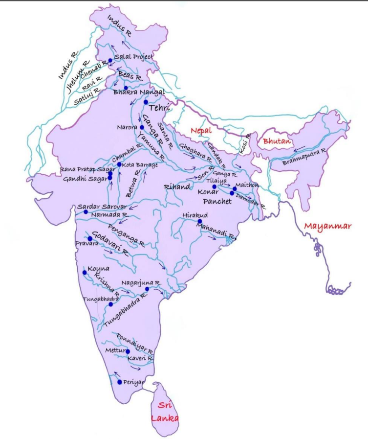
Part 1: The 'Rebel' Rivers (Discordant Drainage)
These rivers are powerful. They do not care about the slope or the shape of the land. They follow their own old paths.
1. Antecedent Drainage (The Ancient Grandfathers)
Simple Analogy: Imagine a saw cutting through a log of wood. Even if you push the wood up, the saw stays in the same place and keeps cutting.
Explanation: These rivers existed before the mountains (Himalayas) rose up. As the mountain rose, the river didn't change its path; instead, it cut vertically through the mountain like a saw, creating deep valleys called Gorges.
Key Examples: Indus, Sutlej, Brahmaputra (They cut through the Himalayas).
2. Superimposed Drainage (The Confused Rivers)
Simple Analogy: Imagine drawing a line on a pile of sand. If you dig down, that line eventually hits the hard floor underneath. The line (river) is now stuck on the floor, even if the floor's slope doesn't match the line.
Explanation: These rivers formed on a top layer of soft rock. Over millions of years, they eroded the soft rock and got 'imprinted' or superimposed onto the hard rocks below. They look like they don't fit the current rock structure.
Key Examples: Damodar, Subarnarekha, Chambal (Rivers of the Plateau).
Part 2: The 'Obedient' Rivers (Concordant Drainage)
These rivers are simple. They just follow the slope of the land (Gravity).
3. Consequent Drainage (The Master River)
Simple Analogy: Pour water on a tilted roof. The water runs straight down the slope. That first stream is the Consequent river.
Explanation: The primary river that forms largely due to the initial slope of the land.
Key Examples: Godavari, Krishna, Kaveri (They flow West to East because the land tilts that way).
4. Subsequent Drainage (The First Helper)
Explanation: After the Master River forms, new streams are created by eroding soft rocks nearby. They join the Master River (usually at right angles).
Role: These are the primary tributaries.
Key Example: River Asan (tributary of Yamuna).
5. Obsequent Drainage (The Rebel in the Family)
Simple Analogy: Think of a 'V' shaped valley. If the main river flows down one side, a small stream might flow down the opposite slope to meet it.
Explanation: A stream that flows in the opposite direction to the Master (Consequent) River.
6. Resequent Drainage (The Latecomer)
Explanation: These streams flow in the same direction as the Master River, but they are born much later. They are like the 'grandchildren' of the river family.
| Type | Description | Examples |
|---|---|---|
| Consequent | Follows natural slope of land | Godavari, Kaveri |
| Sequent | Formed after consequent, usually tributaries | Yamuna |
| Subsequent | Erosion of softer rocks after main rivers | Parallel streams |
| Obsequent | Flow opposite to main river | Tributaries of Ganga (Siwalik) |
| Resequent | Later streams, same direction as main river | Minor tributaries |
| Insequent | Random pattern, no structural control | Plateau streams |
| Antecedent | Older than land uplift, maintain course | Indus, Sutlej, Brahmaputra |
| Superimposed | Cut across rocks regardless of structure | Damodar, Subarnarekha, Chambal |
Prelims tips
- Antecedent rivers are older than Himalayas (Indus, Sutlej, Brahmaputra).
- Superimposed drainage ignores rock structures (Damodar, Chambal).
- Obsequent streams flow opposite to the consequent main river.
- Resequent streams flow in same direction but evolve later.
Mains points
- Drainage systems reflect geological history and landform evolution of India.
- Consequent and sequent rivers dominate peninsular India.
- Antecedent rivers highlight tectonic uplift of Himalayas.
- Superimposed systems indicate erosion and denudation over geological time.
- Drainage patterns are crucial for irrigation, settlement, and regional development.
Indus River System (The Western Lifeline)
The Indus is one of the world's longest rivers and the national river of Pakistan. It acts like a massive drainage pipe for the Himalayas, collecting water from melting glaciers and rain, and carrying it all the way to the Arabian Sea. It is also the birthplace of one of the oldest human civilizations.
1. The Epic Journey: From Ice to Ocean
The river's path is like a three-act play:
Act 1: The Origin (Tibet)
Birthplace: It starts near Lake Manasarovar in the Kailash Range (Tibet).
Name: Here, it is called 'Singe Khamban' which means 'Lion’s Mouth'.
Act 2: The Mountain Passage (India)
The Path: It enters India in Ladakh. It flows through a narrow valley between two mountain ranges: the Ladakh Range (top) and the Zanskar Range (bottom).
Key City: It flows past Leh.
Act 3: The Plains (Pakistan)
The Turn: Near Nanga Parbat, it takes a sharp turn South and enters Pakistan (Dardistan region).
The Meeting: It flows down to the plains. At a place called Mithankot, it receives the waters of the 'Panchnad' (the five rivers of Punjab).
The End: It widens near Karachi and empties into the Arabian Sea.
2. The Tributaries (The River Family)
The Indus has many helper rivers. We classify them by which side they join from.
A. Left Bank Tributaries (The Big Ones)
These come from the East (India/Himachal). The most famous are the 'Panchnad' (Five Rivers):
1. Jhelum: The river of Kashmir (flows through Wular Lake).
2. Chenab: The largest tributary (formed by two streams, Chandra and Bhaga).
3. Ravi: Flows through Lahore.
4. Beas: The only one that finishes its journey inside India (meets Sutlej).
5. Sutlej: A long river that starts in Tibet (like the Indus itself).
Visual: Imagine five fingers coming together to form a fist. That 'fist' joins the Indus at Mithankot.
B. Right Bank Tributaries (The Fast Ones)
These come from the West (Afghanistan/Pakistan mountains). They are short and fast.
Kabul River: Joins Indus at Attock.
Kurram, Gomal, Zhob: Flow from the Sulaiman Ranges.
3. Why is the Indus So Important?
Civilization: The Indus Valley Civilization (Harappa/Mohenjo-Daro) grew on its banks 5000 years ago.
Agriculture: It is the 'Breadbasket' of Pakistan. Without Indus canals, Pakistan would largely be a desert.
Politics: The water is shared between India and Pakistan under the Indus Water Treaty (1960).
| River | Origin | Key Fact to Remember |
|---|---|---|
| Indus | Tibet (Mansarovar) | Length: 2880 km. Flows between Ladakh & Zanskar ranges. |
| Jhelum | Verinag (Kashmir) | Flows through Srinagar & Wular Lake. |
| Chenab | Himachal (Baralacha) | Largest tributary. Called 'Chandrabhaga' in HP. |
| Ravi | Himachal (Rohtang) | Flows along the Indo-Pak border for some distance. |
| Beas | Himachal (Rohtang) | Entirely in India. Meets Sutlej at Harike. |
| Sutlej | Tibet (Rakshastal) | Antecedent river. Feeds the Bhakra Nangal Dam. |
| Parameter | Details |
|---|---|
| Origin | Kailash Range glaciers near Lake Mansarovar (Tibet) |
| Length | 2880 km (709 km in India) |
| Mouth | Arabian Sea (east of Karachi) |
| Major Left Tributaries | Shyok, Nubra, Zanskar, Suru, Gilgit, Hunza, Dras |
| Major Right Tributaries | Kabul, Tochi, Khurram, Gomal, Zhob |
| Major Cities | Leh, Hyderabad (Pakistan), Karachi (Pakistan) |
| Major Dams | Tarbela Dam, Kalabagh Dam |
Prelims tips
- Location Trap: The Indus flows North of the Zanskar Range and South of the Ladakh Range.
- Mithankot: The place where the Panchnad (5 rivers) meets the Indus.
- Attock: The place where the Kabul river meets the Indus.
- Indus Water Treaty: India controls the Eastern Rivers (Ravi, Beas, Sutlej). Pakistan controls the Western Rivers (Indus, Jhelum, Chenab).
Mains points
- Geography: Explain how the Indus is an 'Antecedent' river (older than Himalayas) and how it formed the fertile plains of Punjab.
- International Relations: Discuss the strategic importance of the Indus Water Treaty and recent dam constructions (e.g., Kishenganga).
- Environment: Mention the receding glaciers in Tibet and how that threatens the water security of South Asia.
The Ganga River System
To understand the Ganga, you must understand its 'Family'. The Ganga gets its massive size from its children (tributaries). Some come from the icy Himalayas (North), and some come from the dry Peninsular Plateaus (South).
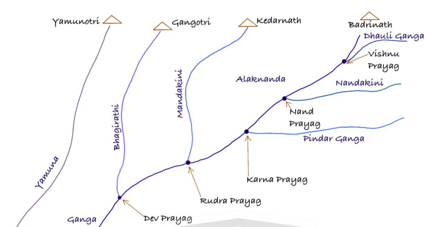
1. The Yamuna: The Parallel Sister
The Yamuna is the longest and most important tributary of the Ganga. It is unique because it flows parallel to the Ganga for a long time before merging.
Origin: Yamunotri Glacier (Bandarpunch Peak), Uttarakhand.
The Path: It flows past Delhi, Mathura, and Agra (Taj Mahal is on its bank).
The End: It merges with the Ganga at Prayagraj (Allahabad). This spot is the holy Sangam.
The Yamuna's Own Family (Tributaries of Yamuna)
Interestingly, the Yamuna collects water from the South (Malwa Plateau) and pours it into the Ganga. These rivers flow South to North:
1. Chambal: Famous for its Ravines (Badlands/Beehad) where dacoits used to hide. It is one of the cleanest rivers.
2. Betwa: The 'Ganga of Madhya Pradesh'.
3. Ken: Famous for the Panna Tiger Reserve.
Note: These rivers do not join Ganga directly; they join Yamuna first.
2. Key Left Bank Tributaries (From Himalayas)
These rivers come from the North (Nepal/Tibet). They bring heavy silt and water, often causing floods.
A. Ghaghara (The Volume Giant)
Origin: Mapchachungo Glacier (Tibet).
Key Fact: It brings the largest volume of water into the Ganga.
B. Gandak (The Narayani)
Origin: Nepal Himalayas.
Key Fact: It forms the boundary between Uttar Pradesh and Bihar for some distance.
C. Kosi (The Naughty River)
Nickname: 'Sorrow of Bihar'.
Why? It is an Antecedent River (older than mountains). It brings huge amounts of sand/silt from Mount Everest region. This sand blocks its own path, forcing the river to jump sideways and flood new villages.
Seven Streams: It is also called 'Saptakoshi' because it is made of 7 streams in Nepal (Arun is the main one).
3. Key Right Bank Tributaries (From Plateau)
Besides Yamuna, these rivers join Ganga directly from the South.
A. Son River (The Gold River)
Origin: Amarkantak Plateau (Madhya Pradesh).
Drainage Pattern: Radial (Same source as Narmada, but flows in opposite direction).
Key Fact: The sand of this river is yellow, resembling gold.
B. Damodar River (The Industrial River)
Nickname: Formerly called 'Sorrow of Bengal' due to floods.
Current Status: Tamed by the Damodar Valley Corporation (DVC), India's first multipurpose river valley project (inspired by TVA of USA).
Region: It flows through the Chotanagpur Plateau (rich in coal and iron), making it the most polluted tributary.
Merger: It joins the Hooghly river (distributary of Ganga), not the main Ganga.
4. The Grand Finale: The Sundarbans
Before meeting the sea, the Ganga (Padma) and Brahmaputra (Jamuna) create the World's Largest Delta.
Name: Named after the 'Sundari' tree (a mangrove species found here).
Ecology: Home to the Royal Bengal Tiger. It is the only mangrove forest in the world inhabited by tigers.
| Aspect | Details |
|---|---|
| Origin | Bhagirathi (Gangotri Glacier) + Alaknanda (Satopanth Glacier) → Devprayag |
| Length | 2,525 km |
| Drainage | Bay of Bengal |
| Delta | Sundarbans, world’s largest delta |
| Major Tributaries | Yamuna, Ghaghra, Gandak, Kosi, Son |
| Distributaries | Bhagirathi-Hooghly, Padma (Bangladesh) |
| Major Dams | Tehri, Farakka Barrage, Bansagar |
| Basin Area | ~8.6 lakh sq. km (India, Nepal, Tibet, Bangladesh) |
| States Covered | Uttarakhand, UP, Bihar, Jharkhand, West Bengal |
| International | Flows into Bangladesh as Padma, joins Brahmaputra & Meghna |
Prelims tips
- Ganga officially begins at Devprayag (Bhagirathi + Alaknanda).
- Panch Prayag = Vishnuprayag, Nandprayag, Karnaprayag, Rudraprayag, Devprayag.
- World’s largest delta = Sundarbans (Ganga-Brahmaputra-Meghna).
- Yamuna is the longest tributary of Ganga.
- Kosi is called ‘Sorrow of Bihar’.
- Farakka Barrage (1975) diverts water to Hooghly to save Kolkata port.
Mains points
- Ganga basin supports nearly 40% of India’s population with fertile alluvial soils.
- Religious-cultural hub: Haridwar, Varanasi, Prayagraj – pilgrimage & rituals.
- Delta & Sundarbans → biodiversity hotspot, cyclone shield for coastal Bengal.
- Economic lifeline: irrigation, transport, fishing, hydropower, tourism.
- Challenges: pollution, floods, groundwater depletion, glacier retreat, interstate disputes.
- Namami Gange mission as a flagship initiative for rejuvenation.
Yamuna River System (Ganga's Greatest Ally)
The Yamuna is the 'Right-Hand Man' of the Ganga. It is the longest tributary in India. It flows parallel to the Ganga like a loyal friend for over 1,300 km before finally merging with it. It connects the capital (Delhi) to the Taj Mahal (Agra).
1. Origin & The Mountain Path
The Birth: It starts at the Yamunotri Glacier on the Bandarpunch Peak (Monkey's Tail Peak) in Uttarakhand.
The Early Days: In the mountains, it receives water from small, icy rivers like the Tons (which actually brings more water than Yamuna itself at that point) and Rishi Ganga.
Entering the Plains: It leaves the mountains at Paonta Sahib (Himachal border) and enters the plains of Haryana and Delhi.
2. The Journey: The Polluted Middle
The Delhi Stretch: As it enters Delhi near the Wazirabad Barrage, the river changes character. Due to heavy sewage and industrial waste, this stretch is unfortunately known as the 'dead river' biologically.
The Historic Cities: It flows past historically significant cities: Delhi (Indraprastha), Mathura (Krishna's birthplace), and Agra (Capital of Mughals).
3. The Grand Finale (Sangam)
After a long journey of 1,376 km, it meets the Ganga at Prayagraj (Allahabad). This confluence is called the Triveni Sangam (Meeting of Three: Ganga, Yamuna, and the invisible Saraswati).
4. The Tributaries (Feeding the River)
Yamuna is unique because its biggest tributaries come from the South (Peninsular India), flowing upwards (North) to meet it.
A. Right Bank (From the South - The Plateau Rivers)
These are the major water suppliers:
1. Chambal: Famous for its clean water and gharials. It flows through the badlands (ravines) of MP, Rajasthan, and UP.
2. Sind: A smaller river from the Vidisha plateau.
3. Betwa: Very important for Bundelkhand. (Remember the Ken-Betwa Link Project).
4. Ken: Passes through Panna Tiger Reserve.
B. Left Bank (From the North)
These are smaller rivers like Hindon (flows near Ghaziabad/Noida) and Rind.
| Feature | Yamuna | Ganga |
|---|---|---|
| Origin | Yamunotri (Bandarpunch) | Gangotri (Gaumukh) |
| Length | 1,376 km | 2,525 km |
| Type | Tributary (Joins Ganga) | Main River (Joins Sea) |
| Key Cities | Delhi, Agra, Mathura | Haridwar, Varanasi, Patna |
| Direction | Flows South then South-East | Flows South-East |
Prelims tips
- Hathnikund Barrage: This is in Haryana. The water released from here determines the flood levels in Delhi.
- Tons River: It is the largest tributary of Yamuna in the Himalayan region (brings more water than Yamuna itself).
- Chambal: It is famous for 'Ravine' topography (Badlands) and is a sanctuary for the Gangetic Dolphin.
- Ken-Betwa: The first river interlinking project involves transferring water from Ken to Betwa.
Mains points
- Urban Pollution: The Yamuna in Delhi (22 km stretch) accounts for nearly 80% of the river's total pollution load. Discuss the failure of YAP (Yamuna Action Plan).
- Inter-State Dispute: Water sharing of Yamuna is a constant conflict between Haryana (upstream) and Delhi (downstream), especially during summer.
- Riverfront Development: Mention projects like the Sabarmati Riverfront and how similar attempts are being planned for Yamuna.
The Brahmaputra River System
The Brahmaputra is one of the world’s largest rivers, originating in the Chemayungdung glacier of the Kailash Range. Known as Tsangpo in Tibet, Dihang in Arunachal Pradesh, and Jamuna in Bangladesh, it plays a vital role in the hydrology, culture, and economy of South Asia.
Origin and Course
Originates from Chemayungdung Glacier, Kailash Range (Tibet).
Flows eastward for ~1200 km across Tibet as Tsangpo ('the purifier').
Major tributary in Tibet: Rango Tsangpo (joins from north).
Cuts deep gorges near Namcha Barwa peak in Central Himalayas.
Enters India as Siang/Dihang in Arunachal Pradesh; later joined by Dibang and Lohit, renamed as Brahmaputra.
Tributaries
Left Bank: Dibang (Sikang), Lohit, Buri Dihing, Noa Dihing, Dhansiri, Dibru, Dikhu, Kalang.
Right Bank: Kameng, Subansiri, Manas, Sankosh (Subansiri originates in Tibet).
Downstream Course
Enters Assam, flows southwest across the Brahmaputra Valley forming fertile alluvial plains.
Enters Bangladesh near Dhubri; called Jamuna after confluence with Teesta.
Merges with Padma (main distributary of Ganga) and later drains into Bay of Bengal via Meghna estuary.
Distinctive Features
Known for frequent floods and high silt load due to young Himalayan sediments.
Forms a vast braided channel system in Assam.
Creates one of the largest riverine islands in the world – Majuli (Assam).
Hydroelectric potential: Subansiri, Siang and Dibang projects are planned/underway.
| Aspect | Details |
|---|---|
| Origin | Chemayungdung Glacier, Kailash Range (Tibet) |
| Name Variations | Tsangpo (Tibet), Siang/Dihang (India), Jamuna (Bangladesh) |
| Length | 2,900 km approx. |
| Major Left Tributaries | Dibang, Lohit, Buri Dihing, Noa Dihing, Dhansiri, Dibru, Dikhu, Kalang |
| Major Right Tributaries | Kameng, Subansiri, Manas, Sankosh |
| Notable Feature | World’s largest riverine island – Majuli |
| Confluence | Merges with Padma (Ganga) and Meghna in Bangladesh before draining into Bay of Bengal |
Prelims tips
- Brahmaputra originates in Tibet as Tsangpo, not in India.
- Known as Jamuna in Bangladesh before merging with Padma (Ganga).
- Majuli in Assam is the world’s largest inhabited river island.
- Carries the highest sediment load among the world’s major rivers.
Mains points
- The Brahmaputra sustains fertile plains of Assam and Bangladesh through annual floods and silt deposition.
- Known for devastating floods but also for enriching agriculture and biodiversity.
- Hydroelectric projects on tributaries like Subansiri and Dibang are vital but controversial due to ecological impacts.
- Transboundary water management with China, India, and Bangladesh is geopolitically sensitive.
- Important for navigation, fisheries, and cultural identity of Northeast India.
Peninsular Drainage System (The Ancient Rivers)
While the Himalayan rivers are young and wild, the Peninsular Rivers are the 'Old and Wise' elders of India. They flow through the stable, hard rocks of the South. Unlike the snow-fed northern rivers, these are Seasonal, depending entirely on the Monsoon.
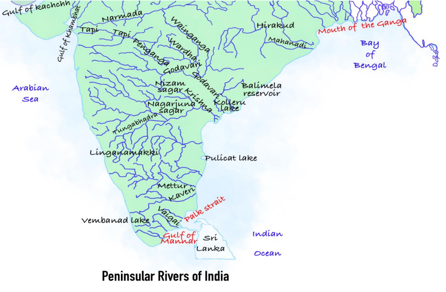
1. The Nature of these Rivers: 'The Grandparents'
Maturity: These rivers are older than the Himalayas. Just like an old person who is set in their ways, these rivers have fixed paths. They do not shift their course or cut deep valleys anymore.
The Valley Shape: Because they are old and flow over hard rocks, their valleys are Broad and Shallow (U-shaped), unlike the deep V-shaped valleys of the Himalayas.
Water Source: They are Rain-fed. During summer, they dry up or shrink significantly. They are not 'Perennial' (flowing forever) like the Ganga.
2. The Great Divide: East vs West Flow
Imagine the Peninsular Plateau (South India) as a Table that is slightly tilted towards the East.
A. The East Flowing Rivers (Following the Slope)
Because of the tilt, most major rivers (Mahanadi, Godavari, Krishna, Kaveri) flow from West to East and empty into the Bay of Bengal.
Feature: They form Deltas (deposit mud/soil) at their mouths.
B. The West Flowing Rivers (The Rebels)
Two major rivers—Narmada and Tapti—refuse to follow the slope. They flow East to West.
Why? They flow inside Rift Valleys (deep cracks in the earth) which slope towards the west.
Feature: They form Estuaries (Clean mouths), NOT Deltas.
3. Key Concept: Delta vs. Estuary
This is the most common confusion for beginners.
Delta (The Builder): When a river reaches the sea, if it is slow and full of mud, it drops the mud there, creating new land. This triangle-shaped land is a Delta. (e.g., Godavari Delta).
Estuary (The Cleaner): If a river flows fast through hard rocks, it has no mud to drop. The sea water rushes into the river mouth. This deep, clean meeting point is an Estuary. (e.g., Narmada Estuary).
| Feature | Himalayan Rivers | Peninsular Rivers |
|---|---|---|
| Age | Young (Youthful) | Old (Mature) |
| Water Source | Glaciers + Rain (Perennial) | Rain only (Seasonal) |
| Path | Meandering (Zig-Zag) | Straight & Fixed |
| Valley | Deep V-Shape (Gorges) | Broad Shallow Valleys |
| Examples | Ganga, Indus | Godavari, Narmada |
Prelims tips
- Hard Rock Effect: Peninsular rivers do NOT form meanders (curves) because the rocks are too hard to cut.
- Estuary Rule: West flowing rivers (Narmada, Tapti) form Estuaries. East flowing rivers form Deltas.
- The Exception: The Kaveri river is almost perennial (flows all year) because its upper part gets rain from the SW Monsoon (June) and lower part gets rain from NE Monsoon (Winter).
- Waterfalls: These rivers form many waterfalls (like Jog Falls) because they flow over hard, uneven rocks.
Mains points
- Why no Deltas on the West Coast? The West flowing rivers (Narmada, Tapti) have a short course, flow swiftly over hard rocks, and don't carry much silt. Hence, they cannot build Deltas.
- Economic Impact: Since these rivers are seasonal, connecting them (River Interlinking) is proposed to transfer surplus water to dry areas (e.g., Polavaram Project on Godavari).
- Hydropower: The steep waterfalls on these rivers are ideal for generating electricity.
East Flowing Rivers – Mahanadi and Godavari River Systems
The Mahanadi and Godavari are two significant east-flowing rivers of Peninsular India, draining into the Bay of Bengal. While the Mahanadi flows through Chhattisgarh and Odisha forming fertile deltas, the Godavari, also called Dakshin Ganga, is the largest peninsular river with an extensive drainage basin across multiple states.
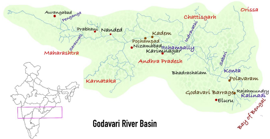
The Mahanadi River System
Rises near Sihawa in the Dandakaranya plateau, Chhattisgarh.
Length: 900 km; Discharges into the Bay of Bengal.
Drainage Basin: 53% in Madhya Pradesh & Chhattisgarh, 47% in Odisha.
Major Cities: Raipur, Bilaspur (Chhattisgarh); Cuttack, Sambalpur, Subarnapur, Jagatsinghpur (Odisha).
Tributaries: Ong, Jonk, Telen, Ib, Mand, Hasdo.
Major Dam: Hirakud Dam.
The Godavari River System
Longest river of Peninsular India (Dakshin Ganga / Vridha Ganga).
Origin: Trimbaka plateau in Nashik district, Maharashtra.
Length: 1465 km; Discharges into the Bay of Bengal.
Drainage Basin: 49% Maharashtra, 21% Madhya Pradesh & Chhattisgarh, 24% Andhra Pradesh, rest in Odisha.
Tributaries: Manjra, Penganga, Wardha, Wainganga, Indravati, Sabri, Pranhita.
Major Cities: Trimbakeshwar, Nashik, Paithan (Maharashtra); Nirmal, Basara, Battapur (Andhra Pradesh).
Important Fact: After Rajahmundry, splits into Gautami Godavari (east) & Vashistha Godavari (west), forming a large delta.
Major Dam: Sri Ram Sagar Dam.
| Feature | Mahanadi | Godavari |
|---|---|---|
| Origin | Sihawa, Dandakaranya plateau (Chhattisgarh) | Trimbaka plateau, Nashik (Maharashtra) |
| Length | 900 km | 1465 km |
| Discharge | Bay of Bengal | Bay of Bengal |
| Drainage Basin | 53% in MP & Chhattisgarh; 47% in Odisha | 49% Maharashtra; 21% MP & Chhattisgarh; 24% Andhra Pradesh; rest Odisha |
| Major Cities | Raipur, Bilaspur, Cuttack, Sambalpur | Trimbakeshwar, Nashik, Paithan, Rajahmundry |
| Tributaries | Ong, Jonk, Telen, Ib, Mand, Hasdo | Manjra, Penganga, Wardha, Wainganga, Indravati, Sabri, Pranhita |
| Major Dams | Hirakud Dam | Sri Ram Sagar Dam |
| Special Feature | Forms fertile delta in Odisha | Splits into Gautami & Vashistha branches, forming a large delta |
Prelims tips
- Mahanadi originates from Sihawa (Chhattisgarh), forms Hirakud Dam, length 900 km.
- Godavari is the largest peninsular river (1465 km), also called Dakshin Ganga.
- Godavari splits at Rajahmundry into Gautami & Vashistha branches.
- Drainage basin of Godavari spreads across 5 states.
Mains points
- Mahanadi supports agriculture and irrigation in Odisha and Chhattisgarh; Hirakud Dam controls floods and provides hydroelectricity.
- Godavari, called Dakshin Ganga, plays a vital role in irrigation, hydro-power, and navigation across central & southern India.
- Both rivers form fertile deltas crucial for rice cultivation.
- Tributaries like Indravati, Wainganga, and Hasdo expand basin connectivity.
- Drainage basin coverage shows inter-state dependence on water resources.
Krishna River System (The Second Giant)
After the Godavari, the Krishna is the most important river in Peninsular India. It is known for its fast flow and rocky path. It flows across the entire width of the Indian peninsula, turning dry lands into green fields before meeting the Bay of Bengal.
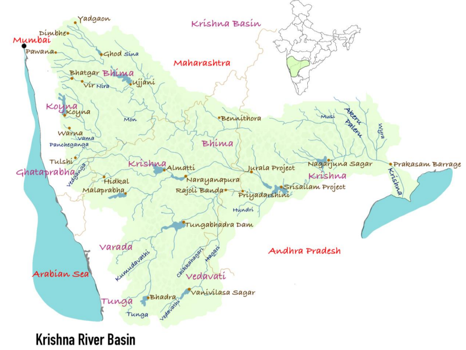
1. Origin & The Journey
The Birthplace: The Krishna rises from a spring near Mahabaleshwar (a famous hill station in the Western Ghats, Maharashtra) at an altitude of 1,337 meters.
The Path: It flows Eastwards for about 1,400 km. It starts in Maharashtra, cuts through Karnataka, flows through Telangana and Andhra Pradesh, and finally creates a fertile delta at Vijayawada before joining the sea.
2. Key Tributaries (The Helping Hands)
The Krishna is fed by many smaller rivers. We divide them by the side they enter from:
A. Left Bank Tributaries (From the North)
1. Bhima: The longest tributary of the Krishna. It flows through Maharashtra and Karnataka.
2. Musi: The city of Hyderabad stands on the banks of this river.
B. Right Bank Tributaries (From the South)
1. Tungabhadra: The most famous tributary. It is formed by the union of two rivers: Tunga and Bhadra. The historic Vijayanagara Empire (Hampi) flourished on its banks.
2. Koyna: Known as the 'Lifeline of Maharashtra' due to its hydroelectric potential.
3. Ghataprabha & Malaprabha: Important rivers for North Karnataka.
3. Major Projects (Dams)
Because the river flows through dry regions, massive dams have been built to store water:
Almatti Dam: Located in Karnataka (Hydroelectric project).
Nagarjuna Sagar Dam: Located on the border of Telangana and Andhra Pradesh. It is the world's largest masonry dam.
Srisailam Dam: A major hydropower project situated in deep forests.
Prakasam Barrage: Located in Vijayawada, it diverts water for irrigation in the delta.
| Aspect | Details |
|---|---|
| River Name | Krishna |
| Origin | Mahabaleshwar, Western Ghats |
| Length | 1290 km |
| Discharge | Bay of Bengal |
| Basin Area | 27% Maharashtra, 29% Andhra Pradesh, 44% Karnataka |
| Major Cities | Mahabaleshwar, Srisailam, Vijayawada, Amaravati |
| Tributaries | Kudali Venna, Koyna, Panchganga, Dudhaganga, Ghataprabha, Malaprabha, Tungabhadra, Bhima, Musi, etc. |
| Major Dams | Prakasam Barrage, Tungabhadra Dam, Nagarjuna Sagar Dam, Bhima Dam, Srisailam Dam |
Prelims tips
- Tungabhadra is the largest tributary by water volume, but Bhima is the longest.
- Pattiseema Lift Irrigation: A project linking Godavari water to the Krishna river to help the drought-prone Rayalaseema region.
- Koyna Dam: Located in a seismic zone (earthquake-prone area) in Maharashtra.
- Kolleru Lake: Located between the deltas of Godavari and Krishna.
Mains points
- Water Disputes: The Krishna Water Disputes Tribunal (KWDT) handles the intense conflict between Karnataka, Telangana, and Andhra Pradesh regarding water sharing.
- Agriculture: The Krishna Delta is one of the most fertile regions in India, vital for rice cultivation.
- Pollution: The Musi river (tributary) is highly polluted due to urban waste from Hyderabad, affecting downstream agriculture.
Cauvery River System (Ganga of the South)
The Cauvery is unique among South Indian rivers. While others dry up in summer, the Cauvery flows almost all year round. This is because it is the 'Double Monsoon River', receiving rain from two different seasons. It is sacred to the people of the South, often called 'Ponni' (The Golden Mother).
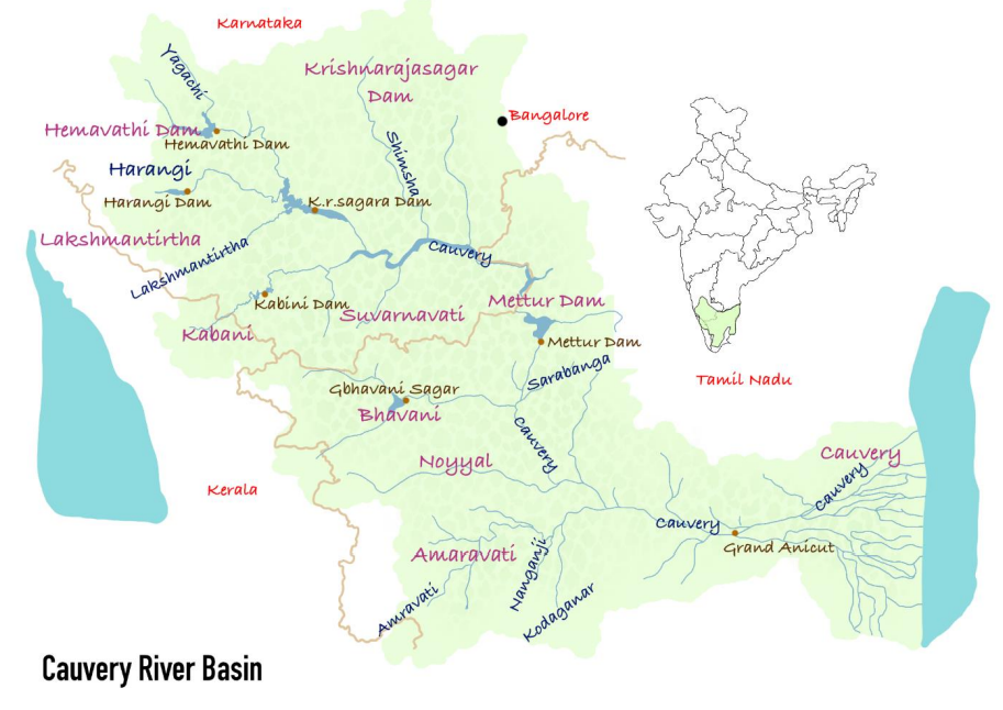
1. Origin & The Journey
The Birthplace: It rises at Talakaveri in the Brahmagiri Hills (Coorg/Kodagu district, Karnataka).
The Path: It flows roughly Southeast through Karnataka and Tamil Nadu. Finally, it empties into the Bay of Bengal at Poompuhar (Tamil Nadu).
2. Why is it Perennial? (The Magic Trick)
Most Peninsular rivers are seasonal. But Cauvery is special:
Upper Course (Karnataka): Receives rain from the South-West Monsoon (June-Sept).
Lower Course (Tamil Nadu): Receives rain from the North-East Monsoon (Oct-Dec) and cyclones.
Result: It has water almost throughout the year, making it the most reliable river for agriculture in the South.
3. Key Landmarks
The Falls: As it leaves the Karnataka plateau, it creates the magnificent Sivasamudram Falls (India's second oldest hydroelectric plant was built here in 1902).
The Islands: In its course, the river splits and rejoins to form river islands. The most famous is Srirangam (near Trichy), home to the massive Ranganathaswamy Temple.
4. The Tributaries
Left Bank (From North): Hemavati, Shimsha, Arkavathi.
Right Bank (From South): Kabini (famous for wildlife), Bhavani, Noyyal, Amaravati.
| Aspect | Details |
|---|---|
| River Name | Cauvery |
| Origin | Tala Cauvery, Brahmagiri hills (Karnataka) |
| Length | 805 km |
| Discharge | Bay of Bengal |
| Basin Area | 3% Kerala, 41% Karnataka, 56% Tamil Nadu |
| Major Cities | Tiruchirappalli, Thanjavur |
| Tributaries | Bhavani, Kabini, Harangi, Hemavati, Shimsha, Arkavati |
| Major Dams | Alalur Dam, Amaravati Dam, Mettur Dam |
| Special Features | Sivasamudram Falls, Riverine island of Srirangam |
Prelims tips
- Geography Trap: Even though the river flows mainly through Karnataka and TN, its drainage basin extends to Kerala and Puducherry too.
- Mettur Dam: Also known as the Stanley Reservoir. It is the lifeline of the Cauvery Delta in TN.
- Grand Anicut (Kallanai): One of the oldest water-diversion structures in the world, built by Chola King Karikalan, is on this river.
- Kabini River: Flows through the Nagarhole National Park.
Mains points
- Water Disputes: The Cauvery Water Dispute is a classic example of federal conflict. Discuss the role of the Cauvery Water Management Authority (CWMA).
- Agriculture: The Cauvery Delta (Thanjavur) is known as the 'Granary of South India'. Discuss the impact of upstream dams on delta agriculture.
- Sand Mining: Illegal sand mining in the riverbed is lowering the water table and harming the ecosystem.
West Flowing Rivers – Narmada and Tapti River Systems
Most rivers in Peninsular India (like Godavari and Krishna) flow East into the Bay of Bengal because the land tilts that way. However, Narmada and Tapti are rebels. They flow West into the Arabian Sea. Why? Because they don't flow on the surface slope; they flow inside deep, narrow cracks in the earth called Rift Valleys.
1. Narmada River System (The Lifeline of Madhya Pradesh & Gujarat)
The Rift Valley Concept: Imagine a long, deep trench dug between two high walls. The Narmada flows in such a trench. To its North are the Vindhya Mountains, and to its South are the Satpura Mountains. Because it is trapped in this narrow, rocky corridor, it flows straight and fast towards the West.
Origin: It begins its journey at the Amarkantak Plateau in Madhya Pradesh. This is a special place because two great rivers start here and go in opposite directions: the Narmada flows West, while the Son River (a tributary of Ganga) flows North.
The Marble Rocks & Waterfalls: Near Jabalpur (MP), the river flows through stunning white marble canyons. Here, it jumps off a cliff to form the Dhuandhar Falls (meaning 'Smoke Cascade' because the mist looks like smoke).
Estuary vs. Delta: This is a key difference. East-flowing rivers carry soft soil and spread out like a hand (Delta) at the sea. The Narmada flows over hard rocks and carries very little soil. So, when it meets the sea at the Gulf of Khambhat, it doesn't block its own mouth. It creates a deep, open mouth called an Estuary.
Key Project: The massive Sardar Sarovar Dam (Gujarat) is built on this river. It provides water to the dry regions of Kutch and Saurashtra. The world's tallest statue, the Statue of Unity, stands on an island in this river.
2. Tapti (Tapi) River System (The Twin)
Relationship: The Tapti is often called the 'Twin' or 'Handmaid' of the Narmada because it runs parallel to it. While Narmada flows between the ranges, Tapti flows South of the Satpura Range.
Origin: It originates from a place called Multai in the Betul district of Madhya Pradesh.
The Basin: While Narmada is the main river of Madhya Pradesh, the Tapti is very important for Maharashtra (especially the Vidarbha and Khandesh regions) before it enters Gujarat.
Major City: The diamond and textile city of Surat is located on the banks of the Tapti.
| Aspect | Narmada | Tapti |
|---|---|---|
| Origin | Amarkantak Plateau (MP) | Multai, Betul District (MP) |
| Length | 1310 km (Longest West Flowing) | 724 km |
| Discharge | Arabian Sea (Gulf of Khambhat) | Arabian Sea (Gulf of Khambhat) |
| Path | Between Vindhya & Satpura Ranges | South of Satpura Range |
| Major Cities | Jabalpur, Omkareshwar, Bharuch | Surat, Burhanpur |
| Tributaries | Hiran, Orsang, Tawa (Longest) | Purna, Girna, Gomai |
| Major Dams | Sardar Sarovar, Indira Sagar | Ukai Dam, Kakrapar Dam |
| Special Feature | Dhuandhar Falls, Marble Rocks | Known as ‘Twin’ of Narmada |
Prelims tips
- Geography Trap: Narmada flows between Vindhya and Satpura ranges. Tapti flows South of Satpura range. Do not confuse their locations.
- Ukai Dam: Located on the Tapti river in Gujarat (Vallabh Sagar).
- Estuaries: Both rivers form Estuaries, NOT Deltas. This is because they flow fast over hard rocks and don't deposit silt.
- Tawa River: It is the longest tributary of the Narmada. It joins from the South (Satpura side).
- Aliabet Island: An island formed at the mouth (estuary) of the Narmada river.
Mains points
- Why West Flowing? Explain the geological faulting (Rift Valley) that forces these rivers to flow against the general Eastward tilt of the Indian Peninsular plateau.
- Economic Importance: Narmada is the 'Lifeline of Gujarat'. Discuss the impact of the Sardar Sarovar Project on irrigation in arid regions (Kutch/Saurashtra) versus the environmental concerns (displacement of people/submergence of forests).
- Hydropower Potential: Because these rivers flow through steep rift valleys, they have excellent potential for generating electricity (e.g., Indira Sagar, Omkareshwar projects).
Major Soil Types (Expanded Details)
Soils are classified into three broad categories: Zonal (influenced by climate and vegetation), Intrazonal (dominated by local conditions like drainage and parent rock), and Azonal (young soils with little profile development). Each type plays a unique role in agriculture, ecosystems, and human livelihoods.
Zonal Soils – Climate & Vegetation Dominated
Tundra Soil: Found in Arctic climatic zones; frozen for most of the year (permafrost); organic matter decomposes slowly.
Podzol Soil: Acidic, ash-coloured, poor in nutrients; typical of coniferous forests in cool moist mid-latitudes.
Chernozem: Very fertile, dark black due to high humus; rich in phosphorus and ammonia; major grain-growing regions in Russia & Ukraine.
Chestnut Soil: Dark brown, formed under steppe grasses; less humus than chernozem but still fertile.
Brunizem (Prairie Soil): Rich humus, found in temperate grasslands; very good for wheat and maize cultivation.
Seirozem: Desert soil, light grey, poor organic content, alkaline in nature; requires irrigation for agriculture.
Latozols (Lateritic Soils): Develop in hot, humid climates; leached soils, poor fertility; used for crops like tea, coffee, cashew after fertilisation.
Intrazonal Soils – Local Factor Dominated
Saline Soils: Also called Reh, Kallar in India; high salt content makes them unsuitable for agriculture unless treated with gypsum/leaching.
Peat Soils: Waterlogged, organic-rich, found in bogs and marshes; act as important carbon sinks and fuel sources.
Calcareous Soils: Derived from limestone/dolomite parent rock; alkaline in nature; suitable for crops like cotton, maize, and pulses.
Azonal Soils – Young, Weakly Developed
Mountain/Scree Soils: Found on slopes; shallow, stony, prone to erosion; support alpine vegetation.
Alluvial Soils: Formed by river deposition; very fertile; stratified in nature (new alluvium = khadar, old alluvium = bhangar in India).
Glacial Soils: Poor in humus, composed of sand, gravel, boulders; found in higher latitudes and mountainous areas.
Loess Soils: Fine-grained, windblown deposits; highly fertile and easy to till; important in China’s wheat belt.
| Category | Soil Type | Properties | Regions |
|---|---|---|---|
| Zonal | Tundra | Frozen, poor organic matter | N. America, Eurasia |
| Zonal | Podzol | Ashy, acidic, poor agriculture | Cool mid-latitudes, coniferous forests |
| Zonal | Chernozem | Black, nutrient-rich, fertile | Russia, Ukraine, Canada, USA |
| Zonal | Chestnut | Dark brown, steppe grassland, humus-rich | Mongolia, China, USA |
| Zonal | Brunizem | Humus-rich, good for cereals | Prairie regions, USA, Europe |
| Zonal | Seirozem | Grey desert soil, poor humus | Turkmenistan, W. USA |
| Zonal | Latozols | Lateritic, red/yellow, iron-rich | Amazon, Brazil, SE Asia |
| Intrazonal | Saline | Salt-affected, alkaline | Arid/semi-arid regions |
| Intrazonal | Peat | Waterlogged, organic-rich | Cold, humid bogs/marshes |
| Intrazonal | Calcareous | CaCO3-rich, alkaline | Limestone regions |
| Azonal | Mountain/Scree | Rocky, shallow, erosion-prone | High mountains, moraines |
| Azonal | Alluvial | Fertile, stratified | Indo-Gangetic plain, Yangtze basin |
| Azonal | Glacial | Gravelly, poor humus | Glaciated regions |
| Azonal | Loess | Windblown silt, fertile | China, Great Plains, Europe |
Prelims tips
- Chernozem = 'Black Earth' → very fertile; major grain belt.
- Podzol = acidic, ash-like soil, poor for agriculture.
- Saline soils in India = Reh, Kallar.
- Alluvial soils = Khadar (new) and Bhangar (old).
- Loess soils = windblown, fertile, found in China’s wheat belt.
Mains points
- Zonal soils highlight the global climatic influence on pedogenesis (tundra → podzol → chernozem → laterite).
- Intrazonal soils demonstrate the importance of local geology (limestone → calcareous; evaporation → saline).
- Azonal soils are agriculturally significant due to their fertility (alluvial, loess).
- Soil types reflect ecosystem adaptations and agricultural suitability.
- Knowledge of soil classification is vital for global food security, crop selection, and sustainable land use.
Natural Vegetation of India
Natural vegetation refers to plant communities that grow naturally without human interference. India’s vegetation is highly diverse due to its varied climate, soil, altitude, and rainfall. The distribution ranges from evergreen forests in high rainfall areas to thorn forests in arid regions, and includes unique mangroves in coastal deltas.
Factors Influencing Natural Vegetation
Land and Soil: Natural vegetation mainly occurs on non-agricultural lands. Soil type influences vegetation – e.g., arid soils support cacti and thorn bushes, fertile alluvial soils support dense forests.
Temperature & Humidity: Dictate vegetation characteristics. Tropical evergreen forests in humid Terai areas, montane forests (rhododendrons, junipers) at higher altitudes.
Photoperiod (Sunlight): Duration of sunlight varies with latitude, altitude, and season. Longer photoperiod → faster growth (e.g., summer).
Altitude: Vegetation decreases with altitude. Sun-facing slopes support denser growth than shaded slopes.
Spatial Distribution
High Rainfall Areas (>200 cm): Western Ghats, North-East India, Andaman & Nicobar → Tropical Evergreen forests. No fixed shedding season; year-round growth.
Moderate Rainfall Areas (70–200 cm): Central India, Himalayan foothills → Tropical Deciduous forests (sal, teak). Trees shed leaves in dry season to conserve water.
Low Rainfall/Semi-arid (<70 cm): Rajasthan, Gujarat, Deccan plateau → Thorn & scrub forests; xerophytic plants adapted to dry, coarse soils.
Coastal/Delta Regions: Sundarbans, Godavari, Mahanadi deltas → Mangrove forests; adapted to saline & freshwater mix.
| Rainfall Zone | Vegetation Type | Regions | Key Features |
|---|---|---|---|
| >200 cm | Tropical Evergreen Forests | Western Ghats, NE India, Andaman & Nicobar | Year-round green, no leaf-shedding season |
| 70–200 cm | Tropical Deciduous Forests | Central India, Himalayan foothills | Leaves shed in summer; teak & sal dominant |
| <70 cm | Thorn & Scrub Forests | Rajasthan, Gujarat, Deccan Plateau | Cacti, thorny bushes, drought-adapted plants |
| Coastal/Delta | Mangroves | Sundarbans, Godavari, Mahanadi deltas | Saline-tolerant vegetation (e.g., Sundari tree) |
Prelims tips
- Khadar-Bhangar distinction is important for Alluvial soils, but in vegetation context → rainfall zones matter.
- Evergreen forests = >200 cm rainfall, no definite leaf-shedding.
- Deciduous forests = 70–200 cm rainfall, teak & sal important.
- Thorn forests = <70 cm rainfall, xerophytic plants.
- Mangroves = saline environment, Sundari tree (Sundarbans).
Mains points
- Natural vegetation in India reflects rainfall gradients and altitude differences.
- Evergreen forests in high rainfall zones conserve biodiversity and regulate monsoon.
- Deciduous forests cover maximum area and provide timber resources (teak, sal).
- Thorn forests highlight adaptations to arid climates, sustaining pastoral economy.
- Mangroves act as natural coastal shields against cyclones and tsunamis.
- Conservation challenges include deforestation, urbanization, and climate change.
Classification of Natural Vegetation in India
India is a land of great variety. Because rainfall and temperature vary from Kashmir to Kanyakumari, our forests vary too. We classify them into five major types based on Climate (mainly rainfall). From the dense Evergreen forests that never turn brown, to the Thorny bushes of the desert, each has a unique ecosystem.
Major Types of Vegetation
Think of vegetation as a mirror of rainfall. Where rain is heavy, forests are dense. Where rain is low, forests are sparse.
1. Tropical Evergreen Forests (The Rain Lovers)
2. Tropical Deciduous Forests (The Monsoon Forests)
3. Tropical Thorn Forests and Scrubs (The Desert Warriors)
4. Montane Forests (The Mountain Dwellers)
5. Mangrove Forests (The Coastal Guards)
1. Tropical Evergreen Forests
Why 'Evergreen'? Do these trees never shed leaves? No. They do shed leaves, but not all at the same time. Different species shed leaves at different times, so the forest always looks green.
Climate Requirements: Heavy rainfall (>200 cm) and short dry season. Hot and humid all year round.
Structure (Stratification): These forests look like a multi-storied building. High trees (60m+) at the top, followed by smaller trees, shrubs, and creepers at the bottom. The canopy is so thick that sunlight hardly reaches the ground.
Distribution: Western slopes of Western Ghats (Kerala/Karnataka), Lakshadweep, Andaman & Nicobar, and Upper Assam.
Flora (Trees): Hardwood trees like Ebony, Mahogany, Rosewood, Rubber, and Cinchona.
Fauna (Animals): Elephants, Monkeys, Lemurs. The One-horned Rhinoceros is found in the jungles of Assam and West Bengal.
2. Tropical Deciduous Forests
The Monsoon Connection: These are the most widespread forests in India. They depend heavily on the Monsoons.
Why 'Deciduous'? To survive the dry summer, these trees shed their leaves for about 6-8 weeks. This stops water loss through transpiration.
Classification: They are divided into two based on water availability:
Moist Deciduous (100-200 cm rain): Found in NE States, Foothills of Himalayas, Jharkhand, Odisha. (Main Tree: Teak).
Dry Deciduous (70-100 cm rain): Found in peninsular plateau, Bihar, UP. (Main Trees: Teak, Sal, Peepal, Neem).
Economic Value: These forests are commercially the most important (Timber, Sandalwood).
Fauna: Lion, Tiger, Pig, Deer, and Elephant.
| Feature | Evergreen Forests | Deciduous Forests |
|---|---|---|
| Rainfall | High (>200 cm) | Moderate (70–200 cm) |
| Appearance | Green all year round | Brown/Leafless in Summer |
| Density | Very Dense (Impenetrable) | Less Dense (Park-like) |
| Wood Type | Hardwood (Difficult to cut/transport) | Valuable Timber (Teak/Sal) |
| Key Locations | Western Ghats, Andaman, North East | MP, UP, Bihar, Odisha |
Prelims tips
- Teak (Sagwan) is the most dominant species of Tropical Deciduous forests.
- Shola Forests: These are temperate forests found in the Nilgiris, Anaimalai, and Palani hills (South India) inside Evergreen areas.
- Sandalwood: It grows in Dry Deciduous forests (Karnataka/Andhra).
- Commercial Use: It is easier to exploit Deciduous forests than Evergreen forests because Evergreen forests are too dense and have mixed species.
Mains points
- Biodiversity vs Economy: Evergreen forests are biodiversity hotspots (genetic pool) but are hard to log commercially. Deciduous forests are the backbone of India's timber industry.
- Human Impact: Deciduous forests have faced the most destruction because they are located in fertile plains (UP, Bihar) suitable for agriculture.
- Conservation: Discuss the importance of 'Sacred Groves' in protecting rare species in these forests.
Tropical Thorn Forests and Montane Forests of India
Tropical thorn forests occur in arid and semi-arid regions with less than 70 cm rainfall, while montane forests appear in high-altitude areas, forming successive vegetation belts from tropical to tundra types. Both vegetation zones showcase adaptations to extreme climates and support unique biodiversity.
Tropical Thorn Forests and Scrubs
Distribution: Areas with <70 cm rainfall; NW India, Gujarat, Rajasthan, MP, Chhattisgarh, UP, Haryana.
Vegetation: Thorny trees, bushes, scattered distribution, deep roots. Stems succulent for water storage; small, thick leaves to minimize evaporation.
Tree Species: Acacias, palms, euphorbias, cacti.
Fauna: Rats, mice, rabbits, foxes, wolves, tigers, lions, wild asses, horses, camels.
Montane Forests
Vegetation Zonation: Vegetation changes with altitude (similar to tropical → tundra transition).
Wet Temperate Forests (1000–2000 m): Evergreen broadleaf trees like oaks, chestnuts.
Coniferous Forests (1500–3000 m): Pine, deodar, silver fir, spruce, cedar; mainly southern Himalayas, NE highlands.
Alpine Vegetation (>3600 m): Silver fir, junipers, birches; stunted near snow-line; alpine grasslands used for grazing by Gujjars & Bakarwals.
Tundra Vegetation: At highest altitudes; mosses, lichens dominate.
Fauna: Kashmir stag, spotted deer, wild sheep, jackrabbit, Tibetan antelope, yak, snow leopard, ibex, bears, red panda, thick-haired sheep & goats.
| Feature | Tropical Thorn Forests | Montane Forests |
|---|---|---|
| Rainfall | <70 cm | Varies by altitude |
| Distribution | NW India, Gujarat, Rajasthan, MP | Himalayas, NE hills, southern highlands |
| Vegetation | Acacias, palms, euphorbia, cactus | Oaks, chestnut, pine, deodar, fir, spruce |
| Adaptations | Succulent stems, small leaves | Altitude-based zonation (tropical → tundra) |
| Fauna | Camels, wild asses, lions, foxes | Snow leopard, yak, red panda, ibex |
Prelims tips
- Thorn forests = <70 cm rainfall, xerophytic plants (acacia, cactus).
- Montane forests show altitude-based succession: temperate → alpine → tundra.
- Yak, snow leopard, red panda = Montane fauna.
- Camels, wild asses = Thorn forest fauna.
Mains points
- Thorn forests represent xerophytic adaptations, important for survival in semi-arid India.
- Montane forests provide ecosystem services like water regulation, carbon sequestration, and biodiversity support.
- Altitude-based vegetation zones in Himalayas are comparable to latitudinal vegetation from tropics to poles.
- Nomadic pastoralists like Gujjars & Bakarwals depend on alpine grasslands for grazing.
- Both forest types face threats: desertification in thorn regions, deforestation and climate change in montane areas.
Mangrove Forests and Medicinal Plants of India
Mangroves are special forests that live in salty water where rivers meet the sea. They act as a shield against cyclones. India is also known as the 'Botanical Garden of the World' because of its vast collection of medicinal plants used in Ayurveda to cure diseases naturally.
1. Mangrove Forests (The Coastal Guards)
What are they? Most trees die in salty water, but Mangroves thrive in it. They are found in Deltas (where rivers dump mud into the sea).
Special Features:
Breathing Roots (Pneumatophores): Their roots grow upwards out of the mud to breathe air, because the muddy soil has no oxygen.
Tangled Roots: Their roots look like a messy net. This holds the soil together and stops coastal erosion.
Distribution in India:
West Bengal: The Sundarbans (Ganga-Brahmaputra Delta) is the largest mangrove forest in the world.
Odisha & Andhra: Mahanadi, Godavari, and Krishna deltas.
Key Tree: The Sundari tree provides hard, durable timber (used for making boats).
Wildlife: Famous for the Royal Bengal Tiger (the only tigers in the world that swim in salty water), crocodiles, and turtles.
2. Medicinal Plants (The Green Pharmacy)
India has a rich history of using plants as medicine (Ayurveda). Out of 2,000 recorded plants, about 500 are used regularly.
Key Plants & Uses:
Sarpagandha: Used to treat High Blood Pressure. (Note: It is found only in India).
Neem: The 'Village Pharmacy'. It kills bacteria and cures skin diseases.
Tulsi: The Holy Basil. Used for cough, cold, and boosting immunity.
Jamun: Its seeds are crushed into powder to control Diabetes.
Arjun: The juice of leaves is good for earaches and regulating blood pressure.
Babool: Its gum is used as a tonic, and leaves cure eye sores.
| Plant Name | Primary Cure/Use |
|---|---|
| Sarpagandha | Blood Pressure (Endemic to India) |
| Jamun | Diabetes (Seed powder), Digestion |
| Arjun | Blood Pressure, Earache |
| Neem | Antibiotic, Skin infection |
| Tulsi | Cough, Cold, Immunity |
| Kachnar | Asthma, Ulcers |
Prelims tips
- Unique to India: Sarpagandha is the only medicinal plant listed in NCERT as being found only in India.
- Breathing Roots: The technical term for mangrove roots that grow upwards is Pneumatophores.
- World Record: The Sundarbans is the largest single block of tidal halophytic mangroves in the world.
- Vivipary: Mangrove seeds germinate (start growing) while still attached to the parent tree, so they don't drown in the water when they fall.
Mains points
- Disaster Management: Explain the role of Mangroves as a 'Bio-Shield'. They reduced the impact of the 2004 Tsunami and several cyclones in Odisha/West Bengal.
- Blue Economy: Mangroves are breeding grounds for fish and crabs, supporting the livelihoods of fishermen.
- Traditional Knowledge: The importance of documenting tribal knowledge of medicinal plants before it is lost or patent-pirated (Biopiracy).
Mineral Resources in India
Minerals are naturally occurring substances with definite chemical composition, while ores are mineral-rich rocks extracted for commercial use. India is richly endowed with a wide variety of mineral resources distributed across different geological regions, including metallic, non-metallic, and energy minerals.
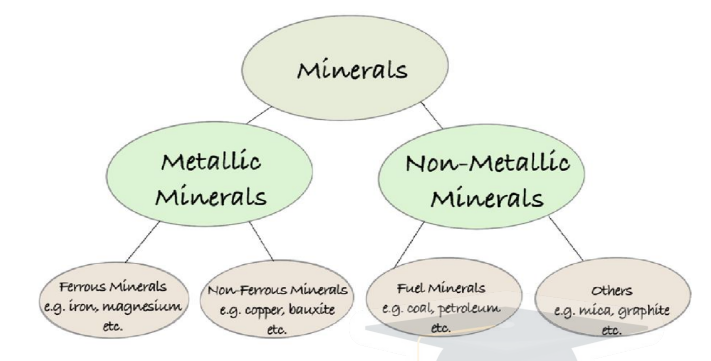
Types of Minerals
Metallic Minerals: Iron ore, copper, bauxite, manganese, zinc, lead, etc.
Non-Metallic Minerals: Mica, limestone, gypsum, salt, phosphorite, etc.
Energy Minerals: Coal, petroleum, natural gas, uranium, thorium, lignite.
Distribution of Mineral Resources in India
1. Northwestern Plateau Region
Associated with Dharwar system of rocks; stretches from Aravallis (Rajasthan) to parts of Gujarat.
Major Minerals: Copper, zinc.
Rajasthan: Sandstone, granite, marble, gypsum, salt.
Gujarat: Oil, natural gas, salt reserves.
2. South-Western Plateau Region
Covers Karnataka, Goa, parts of Tamil Nadu & Kerala.
Minerals: Bauxite, high-grade iron ore, manganese, limestone.
Neyveli (Tamil Nadu): Lignite deposits.
Kerala: Monazite, thorium (radioactive minerals).
Goa: Rich in iron ore deposits.
3. North-Eastern Plateau Region
Includes Odisha Plateau, West Bengal, Jharkhand (Chhotanagpur), parts of Chhattisgarh.
Minerals: Coal, iron ore, bauxite, manganese, mica.
Other Areas/Regions
Himalayan Belt (Eastern & Western): Copper, lead, zinc, cobalt, tungsten.
Assam Valley: Oil deposits.
Mumbai High (offshore): Major oil resources.
| Region | Minerals Found |
|---|---|
| Northwestern Plateau (Rajasthan, Gujarat) | Copper, Zinc, Sandstone, Granite, Marble, Gypsum, Oil, Gas, Salt |
| South-Western Plateau (Karnataka, Goa, TN, Kerala) | Bauxite, Iron ore, Manganese, Limestone, Lignite (Neyveli), Monazite, Thorium |
| North-Eastern Plateau (Odisha, Jharkhand, WB, Chhattisgarh) | Coal, Iron ore, Bauxite, Manganese, Mica |
| Himalayan Belt | Copper, Lead, Zinc, Cobalt, Tungsten |
| Assam Valley | Oil |
| Mumbai High (Offshore) | Oil and Natural Gas |
Prelims tips
- Dharwar system → Copper & Zinc in Rajasthan & Gujarat.
- Neyveli (Tamil Nadu) → Lignite.
- Kerala → Monazite & Thorium deposits.
- Chhotanagpur plateau → Coal, Iron ore, Bauxite, Manganese, Mica.
- Mumbai High → Offshore oil & gas.
Mains points
- India’s mineral resources are unevenly distributed, concentrated in peninsular plateaus and Himalayan belts.
- Chhotanagpur Plateau is the richest mineral belt of India (coal, iron ore, bauxite, mica).
- Rajasthan & Gujarat dominate in building materials and petroleum resources.
- Strategic minerals like thorium in Kerala and oil in Mumbai High are critical for energy security.
- Sustainable mining and environmental safeguards are crucial to balance resource extraction with ecological protection.
Ferrous Metallic Minerals – Iron Ore in India
Iron ore is the most important ferrous mineral, primarily used for steel production (98%). India is rich in iron ore deposits, with Odisha being the largest producer, followed by Jharkhand, Chhattisgarh, Karnataka, Maharashtra, Telangana, and Andhra Pradesh.
Types of Iron Ore
Magnetite: >70% metallic iron; black; magnetic properties; most valuable type.
Hematite: 65–70% metallic iron; red-brown in color; major commercial ore.
Siderite: 40–50% metallic iron; brown; contains iron & carbon; more impurities.
Limonite: <50% metallic iron; yellow; impure; low-grade ore.
Characteristics
Colors vary: rusty red, deep purple, yellow, dark grey.
Generally rich in iron oxides.
Major industrial importance for steelmaking.
Uses of Iron Ore
Steel Production: ~98% of iron ore is used for making steel.
Other Uses:
- Powdered iron in auto parts, catalysts, certain steels.
- Radioactive iron for medicine.
- Iron compounds used in paints, inks, cosmetics, and plastics.
Distribution of Iron Ore in India
Odisha: Largest producer; Sundergarh, Mayurbhanj, Kendujhar. Major mines: Gurumahisani, Sulaipet, Badampahar, Kiruburu, Bonai.
Jharkhand: Noamundi, Gua in Singhbhum districts.
Chhattisgarh: Durg, Dantewada, Bailadila, Dalli-Rajhara mines.
Karnataka: Ballari, Baba Budan Hills, Kudremukh (Chikmagalur), Shivamogga, Chitradurga, Tumakuru.
Maharashtra: Chandrapur, Bhandara, Ratnagiri.
Telangana: Karimnagar, Warangal.
Andhra Pradesh: Kurnool, Cuddapah, Anantapur.
| Type | Iron Content | Color | Properties |
|---|---|---|---|
| Magnetite | >70% | Black | Magnetic, most valuable |
| Hematite | 65–70% | Red-brown | Major commercial ore |
| Siderite | 40–50% | Brown | Contains carbon; impure |
| Limonite | <50% | Yellow | Low-grade; impure |
Prelims tips
- Magnetite has >70% iron; most valuable, magnetic properties.
- Hematite is India’s most important iron ore (65–70% Fe).
- Odisha is the largest producer of iron ore in India.
- Major mines: Bailadila (Chhattisgarh), Kudremukh (Karnataka), Noamundi (Jharkhand).
Mains points
- Iron ore is the backbone of the steel industry, contributing to industrial growth and infrastructure.
- Odisha and Chhattisgarh form the core of India’s iron ore belt.
- Export of iron ore is a significant contributor to India’s trade, though restricted at times for domestic demand.
- Illegal mining, environmental damage, and displacement of tribal communities are key challenges.
- Policy focus is on sustainable mining, beneficiation, and value addition to reduce dependence on imports of finished steel.
Manganese and Copper – Distribution and Uses in India
Manganese is a vital ferroalloy metal used in steelmaking, batteries, and chemicals, while Copper is a key non-ferrous metal widely used in electrical works, alloys, and industry. India is a major producer of both, with Madhya Pradesh leading in manganese and copper production.
Manganese
Characteristics: Hard, heavy, silvery metal; exploited from ores like Pyrolusite and Psilomelane, and also from nodules on the deep seafloor.
Uses:
- Steel contains ~1% manganese, improving strength, workability, and resistance (railway tracks, safes, rifle barrels, prison bars).
- Used as an oxidizer in chemical industries for disinfectants and chemicals.
- Used in making electric batteries, paints, and plastics.
Largest Producer (World): China.
Distribution in India:
- Madhya Pradesh (Largest): Balaghat, Chhindwara, Nimar, Mandla, Jhabua.
- Maharashtra: Nagpur, Bhandara, Ratnagiri.
- Odisha: Bonai, Kendujhar, Sundergarh, Gangpur, Koraput, Kalahandi, Bolangir.
- Karnataka: Dharwar, Ballari, Belagavi, North Canara, Chikkmagaluru, Shivamogga, Chitradurga, Tumakuru.
- Others: Telangana, Goa, Jharkhand (minor producers).
Copper
Characteristics: Soft, brown non-ferrous metal; found in igneous and metamorphic rocks.
Primary Ores: Chalcopyrite, copper sulfide, basic carbonates.
Extraction: Gold, silver, lead, zinc are also extracted as by-products.
Uses:
- Good conductor of heat & electricity → wires, transformers, generators, electronics.
- High malleability → metallurgical industry (cables, fittings, auto parts).
- Alloy making:
- With Tin → Bronze.
- With Zinc → Brass.
- With Nickel → Monel metal.
- With Gold → Guinea gold.
- With Aluminium → Duralumin.
Largest Producer (World): Chile.
Distribution in India:
- Madhya Pradesh (Largest): Balaghat.
- Rajasthan: Jhunjhunu, Alwar.
- Jharkhand: Singhbhum.
| Mineral | Characteristics | Uses | Largest Producer (India) | Major States |
|---|---|---|---|---|
| Manganese | Hard, silvery; ores: Pyrolusite, Psilomelane | Steel, chemicals, batteries, paints, plastics | Madhya Pradesh | MP, Maharashtra, Odisha, Karnataka, Telangana, Goa, Jharkhand |
| Copper | Soft, brown, non-ferrous | Electrical works, alloys, auto parts | Madhya Pradesh | MP, Rajasthan, Jharkhand |
Prelims tips
- Manganese: Essential ferroalloy metal; improves steel strength.
- India’s largest manganese producer: Madhya Pradesh (Balaghat).
- Copper: Key non-ferrous metal; used in electrical industry.
- India’s copper production: MP (Balaghat), Rajasthan (Jhunjhunu, Alwar), Jharkhand (Singhbhum).
Mains points
- Manganese is indispensable in steelmaking and allied industries; India ranks among top global producers.
- Copper is vital for electrical and electronic industries; alloy production adds industrial value.
- Mining belts: MP-Odisha belt is central for both manganese and copper production.
- Challenges: Over-extraction, environmental impact, depletion of high-grade ores.
- Policy focus: Sustainable mining, technological upgradation, and reducing import dependence on refined copper.
Land Use Categories in India
The Agricultural Statistics (1949) classified land in India into 9 categories. These categories are recorded in Land Revenue Records and reflect how land is used in agriculture, forestry, settlements, and other purposes.
Overview
9-fold classification of land in India was first introduced in 1949.
Maintained in Land Revenue Records by the Ministry of Agriculture.
Reflects share of forests, agriculture, fallows, wasteland, and settlements.
Net sown area is the largest category, covering about 42.4% of land.
Forest cover (24.62%) is crucial for ecology, biodiversity, and livelihoods.
| Category | Share (%) | Details |
|---|---|---|
| Forests | 24.62% | Forest cover indicates presence of trees; Forest area means legal status in government records. |
| Net Sown Area | 42.4% | Land used for sowing and harvesting crops; 3–4 crops grown annually. |
| Misc. Tree Crops | 1% | Privately owned cultivable land with orchards, bamboo, bushes, etc. |
| Non-Agricultural Uses | 8.7% | Settlements, industries, roads, canals, ponds, shops, railways. |
| Permanent Pastures & Grazing Land | 3.92% | Owned by Panchayat/Government; used for grazing; part of CPR. |
| Barren & Uncultivable Land | 5.5% | Unfit for cultivation; includes deserts, ravines, hilly terrain. |
| Current Fallows | 4.9% | Left uncultivated for less than 1 year; soil fertility restored naturally. |
| Other Fallow Land | 3.6% | Left uncultivated for more than 1 year but less than 5 years. |
| Culturable Waste Land | 4.41% | Not cultivated for 5+ years; can be reclaimed through improvements. |
| Parameter | Common Property Resources (CPR) | Public/State Resource |
|---|---|---|
| Ownership | Owned by state; communities get ‘use rights’, may/may not have collective ownership. | Exclusively owned by state; people not excluded from enjoying. |
| Examples | Panchayat village lands, community-owned canal irrigation. | Marine fisheries in EEZ, national highways. |
Prelims tips
- Land use classification in India introduced in 1949.
- Net sown area is the largest share (42.4%).
- Forests cover 24.62% of total land.
- Culturable waste land = land not used for 5+ years but reclaimable.
- Permanent pastures & grazing land = Common Property Resources (CPR).
Mains points
- Land use pattern highlights the dominance of agriculture in India’s economy.
- Forests play dual role: ecological balance + livelihood security.
- Fallow and wastelands show scope for increasing agricultural productivity via reclamation.
- Non-agricultural land use reflects rapid urbanization and industrialization.
- CPR and public resources distinction is vital for governance and equitable access.
Indian Agriculture – Agricultural Land Use
India has a geographical area of 328.7 million hectares (2016–17). Out of this, 139.4 million hectares is the net sown area (42.4%), and 200.2 million hectares is the gross cropped area, with a cropping intensity of 143.6%. Agriculture contributes ~17.8% of India's GVA (2019–20).
Agricultural Land Use
Total geographical area: 328.7 million hectares.
Net sown area: 139.4 million hectares (42.4% of total).
Gross cropped area: 200.2 million hectares.
Cropping intensity: 143.6%.
Agriculture & allied sectors: ~17.8% of GVA (2019–20).
Significance
Provides livelihood to more than 55% of Indian population.
Contributes significantly to food security and rural employment.
Backbone of Indian economy with strong forward and backward linkages.
| Parameter | Details |
|---|---|
| Topography & Soil | Different soils and landforms support diverse crops; tea in hilly, drained soils; cotton in black soils (Deccan, Malwa). |
| Climate (Rainfall & Temperature) | Agriculture is monsoon-dependent; rice needs hot-humid climate (100+ cm rainfall); wheat needs cool climate. |
| Parameter | Details |
|---|---|
| Land Related | Size of holdings affects investment capacity; smaller farms mean higher input costs per unit. Land tenancy reforms provide tenure security. |
| Dependent Population | About 55% population still depends on agriculture and allied activities (Economic Survey). |
| Backward Linkages | Quality of seeds, irrigation, mechanization, fertilisers, and credit availability affect agriculture. |
| Forward Linkages | Market access, storage, transport, research hubs, and extension services enhance productivity. |
Prelims tips
- Net sown area: 42.4% of total geographical area (2016–17).
- Cropping intensity: 143.6%.
- Agriculture’s share in GVA (2019–20): 17.8%.
- 55% of Indian population dependent on agriculture (Economic Survey).
Mains points
- Agriculture remains the backbone of Indian economy, providing livelihood to majority population.
- Natural factors like soils, topography, and monsoon critically affect crop distribution.
- Socio-economic factors like land size, tenancy reforms, and rural labour shape productivity.
- Forward and backward linkages highlight agriculture’s interconnection with industry and markets.
- Need for diversification and modernization to reduce monsoon dependency.