
Indian & Physical Geography · UPSC Notes
Air Mass, Fronts & Cyclones — UPSC Geography Notes
Free, exam-focused notes for UPSC Prelims and Mains, with Prelims tips and Mains points for every topic. 15 topics.
Open in the interactive reader: bookmarks, progress tracking and read-aloud.
Air Mass: Characteristics, Classification, and Modification
An air mass is a large body of air with uniform properties, classified based on its source latitude ( Polar/Tropical ) and surface type ( Continental/Maritime ). Their movement leads to modification , determining regional weather, and their interaction at fronts drives the formation of cyclones .
Definition and Origin
A large body of air , typically 1600 km or more in horizontal extent and several km vertically, with homogeneous physical properties (temperature, moisture, lapse rate).
The concept was pioneered by the Norwegian meteorologists V. Bjerknes and J. Bjerknes during World War I as part of the Polar Front Theory.
Criteria of an Air Mass
Extent : Must cover more than 1600 km horizontally and extend several km vertically to ensure sufficient homogeneity.
Uniformity : Must have uniform properties across its extent, derived from prolonged contact with its source region.
Distinction : Must be distinct from surrounding air and retain its general properties while moving over other regions (though modification occurs).
Source Region of Air Masses
The source region is the surface area of Earth from which the air mass derives its properties. Conditions essential for development:
Large and Uniform Topography : The surface must be flat, such as a large ocean, extensive plains, or plateau.
Gentle, Divergent Airflow : Requires anticyclonic conditions (high pressure) to ensure the air remains stagnant and in contact with the surface for a long time. Cyclonic zones cannot be source regions.
Latitudinal Zones : The zones between 20°–35° (Tropical) and 50°–70° (Polar) are the most significant source regions.
Classification System (Standard Codes)
Air masses are primarily classified using two letters:
Thermal Zone (A/P/T/E) : Arctic, Polar, Tropical, Equatorial.
Surface Type (c/m) : Continental (dry) or Maritime (moist).
Modification and Stability (k/w notation)
A third letter indicates the relative temperature of the air mass compared to the underlying surface it is moving over:
'k' (Kalt/Cold) : Air mass is colder than the surface below. This warms the lower layers, making the air mass unstable (convection, clouds, precipitation).
'w' (Warm) : Air mass is warmer than the surface below. This cools the lower layers, making the air mass stable (clear skies, fog/stratus clouds).
Full Classification Examples
cPk (Continental Polar, colder than ground): Often leads to lake-effect snow (unstable).
mTw (Maritime Tropical, warmer than ground): Leads to stability, haze, and fog over colder coastal waters.
| Code | Full Name | Nature (T & M) |
|---|---|---|
| cP | Continental Polar | Cold and Dry |
| mT | Maritime Tropical | Warm and Moist |
| cT | Continental Tropical | Hot and Dry |
| mP | Maritime Polar | Cool and Moist |
| cAk | Continental Arctic (k) | Extremely Cold, Dry, Unstable |
Prelims tips
- Air mass concept developed by the Bjerknes School during WWI (Polar Front Theory).
- Source regions must have stable high pressure (anticyclonic conditions) for stagnation.
- 'k' notation means the air mass is colder than the surface, leading to instability and convective precipitation.
- 'w' notation means the air mass is warmer than the surface, leading to stability and fog/haze.
- The mT air mass from the Arabian Sea is the primary source of Indian Monsoon rainfall.
Mains points
- Air masses are fundamental drivers of global and regional weather, transporting vast quantities of moisture and heat.
- Their interaction at fronts is the primary mechanism for the formation of mid-latitude (temperate) cyclones, which bring winter rains to North India.
- Modification of air masses (e.g., cP air mass moving over the Great Lakes causing lake-effect snow) is a key concept for micro-climatology.
- The Indian monsoon circulation is a seasonal exchange and conflict between the cT (dry) air mass over the land and the mT (moist) air mass from the ocean.
Air Mass: Characteristics, Classification, and Modification
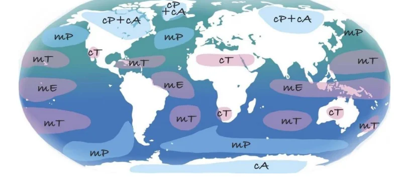
An air mass is a large body of air with uniform properties, classified based on its source latitude ( Polar/Tropical ) and surface type ( Continental/Maritime ). Their movement leads to modification , determining regional weather, and their interaction at fronts drives the formation of cyclones .
Definition and Origin
A large body of air , typically 1600 km or more in horizontal extent and several km vertically, with homogeneous physical properties (temperature, moisture, lapse rate).
The concept was pioneered by the Norwegian meteorologists V. Bjerknes and J. Bjerknes during World War I as part of the Polar Front Theory .
Criteria of an Air Mass
Extent : Must cover more than 1600 km horizontally and extend several km vertically to ensure sufficient homogeneity.
Uniformity : Must have uniform properties across its extent, derived from prolonged contact with its source region.
Distinction : Must be distinct from surrounding air and retain its general properties while moving over other regions (though modification occurs).
Source Region of Air Masses
The surface area of Earth from which the air mass derives its properties. Conditions essential for development:
Large and Uniform Topography : The surface must be flat, such as a large ocean, extensive plains, or plateau.
Gentle, Divergent Airflow : Requires anticyclonic conditions (high pressure) to ensure the air remains stagnant and in contact with the surface for a long time. Cyclonic zones cannot be source regions.
Latitudinal Zones : The zones between 20°–35° (Tropical) and 50°–70° (Polar) are the most significant source regions.
Classification System (Standard Codes)
Air masses are primarily classified using two letters:
Thermal Zone (A/P/T/E) : Arctic, Polar, Tropical, Equatorial.
Surface Type (c/m) : Continental (dry) or Maritime (moist).
Modification and Stability (k/w notation)
A third letter indicates the relative temperature of the air mass compared to the underlying surface it is moving over:
'k' (Kalt/Cold) : Air mass is colder than the surface below. This warms the lower layers, making the air mass unstable (convection, clouds, precipitation).
'w' (Warm) : Air mass is warmer than the surface below. This cools the lower layers, making the air mass stable (clear skies, fog/stratus clouds).
Full Classification Examples
cP (Continental Polar): Cold and dry (e.g., Siberia).
mT (Maritime Tropical): Warm and moist (e.g., Gulf of Mexico, Southern Indian Ocean).
cPk (Continental Polar, colder than ground): Often leads to lake-effect snow (unstable).
| Air Mass | Source Region | Features | Weather |
|---|---|---|---|
| Continental Polar (cP) | Arctic basin, N. America, Eurasia, Antarctica | Dry, cold, stable | Winter: frigid, clear; Summer: less stable, warmer landmasses |
| Maritime Polar (mP) | Oceans between 40°–60° latitudes | Cool, moist, unstable | Winter: humid, cloudy, precipitation; Summer: fair and stable |
| Continental Tropical (cT) | Sahara, West Asia, Australia | Dry, hot, stable | Dry throughout the year, little precipitation |
| Maritime Tropical (mT) | Tropical oceans (Gulf of Mexico, Pacific, Atlantic) | Warm, humid, unstable | Winter: mild, cloudy; Summer: hot, humid, convectional rain |
| Continental Arctic (cA) | High Arctic interiors | Very cold, dry, stable | Extremely cold, clear conditions |
Prelims tips
- Air mass concept developed by the Bjerknes School during WWI (Polar Front Theory).
- Source regions must have stable high pressure (anticyclonic conditions) for stagnation.
- 'k' notation means the air mass is colder than the surface, leading to instability and convective precipitation.
- 'w' notation means the air mass is warmer than the surface, leading to stability and fog/haze.
- The mT air mass from the Arabian Sea is the primary source of Indian Monsoon rainfall.
Mains points
- Air masses are fundamental drivers of global and regional weather, transporting vast quantities of moisture and heat.
- Their interaction at fronts is the primary mechanism for the formation of mid-latitude (temperate) cyclones, which bring winter rains to North India.
- Modification of air masses (e.g., cP air mass moving over the Great Lakes causing lake-effect snow) is a key concept for micro-climatology.
- The Indian monsoon circulation is a seasonal exchange and conflict between the cT (dry) air mass over the land and the mT (moist) air mass from the ocean.
Fronts
Fronts are transitional zones between contrasting air masses, critical in shaping global weather. They form due to differences in temperature , pressure , and humidity . Fronts influence precipitation, storms, and the lifecycle of mid-latitude cyclones , making them vital for weather forecasting.
Definition and Concept
A Front is the boundary zone between two different air masses (e.g., cold/warm, dry/moist) with distinct temperature and moisture properties.
The concept was introduced by Norwegian meteorologists V. Bjerknes and J. Bjerknes during World War I , forming the basis of the Polar Front Theory .
They represent transition zones in global circulation where weather activity is concentrated; the process of their formation is called frontogenesis .
Characteristics of Fronts
Temperature Gradient : Fronts are zones of steep horizontal temperature gradients . The strength of the temperature contrast controls the thickness and sharpness of the frontal zone.
Pressure : Fronts generally occur in low-pressure troughs (low pressure along the boundary), which is why isobars bend near fronts.
Wind Shift : A marked shift in wind direction and speed usually occurs across the frontal boundary.
Weather : Fronts are associated with convergence , leading to the uplift of warm air, turbulence , clouds , and precipitation .
Cyclogenesis : Fronts, particularly the polar front, are the genesis zones ( cyclogenesis ) for mid-latitude (temperate) cyclones .
Types of Fronts
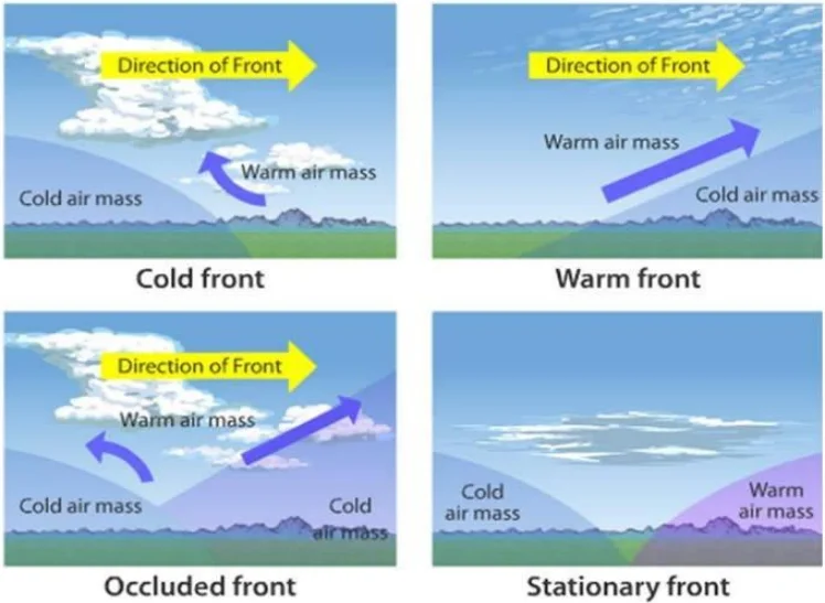
Stationary Front
Occurs when two air masses meet but neither displaces the other (e.g., due to parallel but opposite winds along the boundary).
Weather : Produces prolonged cloudiness , drizzle , and fog ; can persist for days, leading to monotonous weather.
Warm Front
Forms when warm air advances over cold, dense air, rising gently (shallow slope, typically 1:100–200).
Cloud Sequence : The warm air cools slowly, leading to a sequence of stratified clouds: Cirrus → Cirrostratus (forms halos ) → Altostratus → Nimbostratus (rain).
Weather : Produces widespread, light-to-moderate continuous rain/snow (or drizzle) over a large area ahead of the front.
Cold Front
Forms when cold, dense air advances and forcefully undercuts warm air , causing rapid uplift (steep slope, typically 1:50–100).
Cloud Sequence : The rapid uplift leads to intense convection, forming towering clouds: Cumulus → Cumulonimbus .
Weather : Produces heavy rainfall , thunderstorms , squalls , and hailstorms over a narrow band. Weather changes rapidly: sharp drop in temperature , pressure rise, and clear skies after passage.
Occluded Front
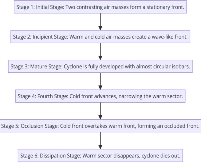
Forms when a fast-moving cold front overtakes a warm front , forcing the entire warm sector (warm air mass) to be displaced aloft (above the surface).
Weather : Complex—combines features of both warm and cold fronts, often bringing a period of heavy, erratic rain and stormy conditions .
Lifecycle : Marks the mature and decaying stage of extratropical cyclones (common in Europe and North America).
Global Significance
Heat Transport : Frontal systems are essential components of the global circulation system , efficiently transporting heat and moisture from equatorial regions toward the poles.
Aviation Hazards : Fronts are major aviation hazards due to the associated turbulence , icing , and poor visibility .
Climate Influence : The long-term pattern of frontal rainfall defines many mid-latitude climate zones and agricultural suitability (e.g., Western Disturbances, which are frontal systems, bring crucial winter rain to North India).
| Front Type | Slope | Cloud Sequence | Weather |
|---|---|---|---|
| Stationary | Almost flat | Stratus, Nimbostratus | Persistent cloudiness, drizzle, fog |
| Warm | Gentle (1:100–200) | Cirrus → Cirrostratus → Altostratus → Nimbostratus | Steady widespread rain/snow |
| Cold | Steep (1:50–100) | Cumulus → Cumulonimbus | Heavy showers, thunderstorms, hail |
| Occluded | Variable | Mixed (cumulus + nimbus) | Erratic rain, stormy conditions |
Prelims tips
- Stationary fronts cause persistent cloudiness and drizzle.
- Warm fronts → halos around Sun/Moon due to cirrostratus clouds.
- Cold fronts → steep slope, heavy showers, Cumulonimbus clouds.
- Occluded fronts → found in the mature/decaying stage of mid-latitude cyclones.
- Western disturbances affecting India are frontal systems originating from the Mediterranean.
Mains points
- Fronts represent the dynamic interaction between air masses and are the birthplace of mid-latitude cyclones (cyclogenesis).
- The steepness of the cold front leads to rapid, violent weather, while the shallow slope of the warm front leads to gentler, long-lasting precipitation.
- Occluded fronts indicate the dissipation of the frontal system, marking the end of the extratropical cyclone's lifecycle.
- Understanding frontal meteorology is essential for agriculture (winter rainfall in North India) and aviation safety.
Cyclones
Cyclones are large-scale low-pressure systems characterized by fast inward air circulation. They occur in both tropical and temperate regions and are vital for redistributing heat and moisture globally. While Tropical Cyclones cause high-intensity destruction, Temperate Cyclones influence widespread, gentler weather.
General Definition
A Cyclone is a large air mass characterized by a strong, rapid, inward circulation of air around a low-pressure center.
The term is derived from the Greek word 'cyclos' meaning 'coils of a snake'.
Coriolis Effect : Air circulates anticlockwise in the Northern Hemisphere and clockwise in the Southern Hemisphere .
The two primary types are Tropical Cyclones (thermal origin) and Temperate/Extratropical Cyclones (frontal origin).
Temperate (Extratropical or Wave) Cyclones
Location : Primarily found in the mid-latitudes (35°–65° N and S) , forming over both land and sea.
Formation : Formed by frontogenesis—the dynamic interaction between two contrasting air masses (cold/dense Polar air and warm/light Tropical air) along the Polar Front.
Shape and Size : They are large (500–2000+ km), often elliptical or V-shaped, defined by distinct warm and cold frontal surfaces.
Wind Velocity : Moderate (30–80 km/h). They are less violent than tropical cyclones.
Movement : They move from west to east under the influence of the westerly jet stream and prevailing westerlies.
Weather : Characterized by cloudy skies, variable winds, and widespread, prolonged rain/snow (frontal precipitation), lasting several days.
Indian Context : They are vital as Western Disturbances that bring crucial winter rainfall for Rabi crops in North India.
Tropical Cyclones (Hurricanes/Typhoons)
Location : Confined to 5°–30° latitudes , strictly forming over warm tropical oceans.
Conditions for Formation (Critical Criteria) :
High SST: Sea Surface Temperature > 26.5°C (providing massive latent heat).
Coriolis Force: Requires sufficient Coriolis force, which is why they do not form near the Equator (0°–5°).
Atmospheric Stability: Low vertical wind shear (difference in wind speed/direction with height).
Size and Wind : Smaller (100–1000 km) but characterized by extremely high wind velocity (>120 km/h, up to 300 km/h).
Structure : Highly symmetrical, featuring a clear, calm Eye (center), surrounded by the Eyewall (zone of maximum winds and rain), and outer spiral rain bands.
Movement : Generally track westward and poleward due to the influence of trade winds.
Naming : Called ' Hurricanes ' in the Atlantic/NE Pacific, ' Typhoons ' in the NW Pacific, and ' Cyclones ' in the Indian Ocean/SW Pacific.
Weather : Highly destructive due to intense rainfall, powerful winds, and dangerous storm surges.
Stages of Tropical Cyclones
1. Formation : Low pressure forms over warm water, initiating evaporation and latent heat release.
2. Intensification : Continuous latent heat release strengthens convection and lowers central pressure.
3. Mature Stage : Maximum intensity, characterized by a well-defined eye and sustained wind speeds of hurricane force.
4. Decay : Weakens rapidly when it makes landfall (loss of moisture source and increased surface friction).
Significance and Impact
Positive : Cyclones are essential components of the atmospheric heat engine, helping redistribute heat and moisture poleward and bringing vital rainfall to coastal and arid areas, aiding groundwater recharge.
Negative : Cause catastrophic loss of life and property, floods, destruction of infrastructure, and severe coastal erosion due to storm surges (the most destructive aspect of tropical cyclones).
Climate Link : There is strong evidence that global warming (increased ocean heat content) is contributing to the increasing intensity and rapid intensification rate of tropical cyclones.
| Feature | Tropical Cyclone | Temperate Cyclone |
|---|---|---|
| Location | 5°–30° latitude over warm oceans | 35°–65° latitude , over land & sea |
| Size | 100–1000 km (smaller) | 500–2000 km (larger) |
| Wind Speed | Very High (120–250+ km/h) | Moderate (30–80 km/h) |
| Energy Source | Latent heat release from condensation (ocean heat) | Potential energy from contrasting air masses (frontal collision) |
| Structure | Eye, eyewall , spiral bands (symmetrical) | Frontal system (warm & cold fronts, asymmetrical) |
| Movement | Westward & poleward | West to East (Westerlies) |
| Weather | Intense rain , storms, storm surge | Widespread rain, snow, cloudy weather |
Prelims tips
- Tropical cyclones need sea surface temperature >26.5°C and low wind shear .
- They do not form near the Equator (0°–5°) due to insufficient Coriolis force .
- Temperate cyclones are frontal systems (cyclogenesis) common in mid-latitudes, moving west to east.
- Western disturbances in India are examples of extratropical cyclones.
- Storm surge is the most destructive element of a tropical cyclone.
Mains points
- Cyclones are vital in global circulation , redistributing heat and moisture to maintain the energy balance.
- The Tropical Cyclone's energy is derived from latent heat release (thermal engine), while the Temperate Cyclone's energy comes from potential energy released during frontal interaction.
- The destructive impact of cyclones disproportionately affects coastal settlements and agriculture, necessitating robust early warning systems and disaster mitigation strategies.
- There is a scientific consensus linking global warming (warming oceans) to an increase in the intensity, rainfall rates, and rapid intensification of tropical cyclones globally.
Distribution of Temperate Cyclones
Temperate cyclones develop mainly along polar fronts where warm tropical air masses meet cold polar air masses. They are most common in mid-latitudes (35°–65°) across both hemispheres and strongly influence the weather of North America, Europe, Asia , and parts of the Southern Hemisphere .
I. Northern Hemisphere Major Fronts
Atlantic-Arctic Front
Location : The main cyclogenesis zone is created where the warm North Atlantic Drift current meets the cold Arctic air mass .
Movement & Impact : Cyclones typically move northeastward along the coast and strongly influence the weather of Western Europe (e.g., Britain, Scandinavia, France ), bringing frequent rainfall and storms .
North America Polar Front
Cyclogenesis Hotspot : Cyclones typically develop around the Great Lakes region and the Gulf of Mexico coast due to the convergence of the cold, dry continental polar (cP) air mass and the warmer, moist maritime tropical (mT) air mass.
Movement & Impact : They then move northeastward , bringing severe snowstorms and blizzards to Canada and the northeastern USA .
Mediterranean-Caspian Front (Western Disturbances)
Formation : Cyclones form where cold continental air meets warmer air over the Mediterranean and Caspian seas .
Indian Impact : These extra-tropical cyclones move eastward under the influence of the Sub-tropical Westerly Jet Stream .
They manifest as Western Disturbances in the Indian subcontinent, bringing crucial winter rainfall to northwestern India (Punjab, Haryana, UP) and snowfall to the Himalayas, benefiting Rabi crops .
II. Southern Hemisphere Distribution
Characteristics : The Southern Hemisphere has fewer large landmasses ; therefore, the polar front is more continuous and the cyclones are predominantly oceanic .
Intensity : Lack of sharp, continuous land-sea temperature contrast reduces the intensity and frequency of land-based storms compared to the North.
Movement : Cyclones generally develop between 35°–65° S latitudes and typically move southeastward , bringing widespread rainfall and storms to coastal regions of Southern Chile, South Africa, Australia , and New Zealand (the 'roaring forties' zone).
| Region | Air Mass Interaction | Movement | Impact |
|---|---|---|---|
| Atlantic-Arctic Front | Warm Atlantic vs Cold Arctic | NE towards Europe | Rain, storms in Western Europe |
| North America Polar Front | Continental Polar vs Arctic | NE towards Canada & NE USA | Snowstorms, blizzards |
| Mediterranean-Caspian Front | Continental vs Warm Sea Air | East/Northeast | Western disturbances, winter rain in India |
| Southern Hemisphere | Marine Tropical vs Polar Air | SE | Storms in Chile, South Africa, Australia, NZ |
Prelims tips
- Temperate cyclones mainly occur between 35°–65° latitude (mid-latitudes).
- The Great Lakes region (North America) is a major hotspot for extratropical cyclone development.
- Western disturbances in India are vital frontal systems linked to Mediterranean-Caspian front cyclones.
- Southern Hemisphere cyclones move mostly southeastward in the westerlies .
- Cyclones move West to East in the Northern Hemisphere (Westerlies).
Mains points
- Temperate cyclones , forming along polar fronts , are the dominant weather control factor in mid-latitudes , causing widespread weather changes and precipitation.
- The Mediterranean-Caspian front provides a crucial link between global atmospheric dynamics and the agricultural economy of North India (via Western Disturbances).
- The difference in landmass distribution between the hemispheres explains why Northern Hemisphere cyclones have more intense, geographically focused impact (e.g., North America), while Southern Hemisphere cyclones are more oceanic and widespread .
- These cyclones are fundamental to the redistribution of heat and moisture from the tropics to the poles, playing a key role in the global energy balance.
Tropical Cyclones
Tropical cyclones are violent storms originating in tropical oceans, typically between 5° and 30° latitudes . They derive their immense energy from the latent heat of condensation, move in a spiral form, and are notorious for causing large-scale destruction in coastal regions due to storm surges and high winds.
Definition and Characteristics
Definition : Violent low-pressure systems originating in tropical oceans, generally confined between 5° and 30° latitudes in both hemispheres.
Energy Source : They are thermal in nature, acting as self-propelling heat engines powered by the enormous release of latent heat of condensation from warm, moist air.
Size and Structure : They are smaller than temperate cyclones, typically 30–300 km in diameter, characterized by a highly symmetrical structure: a calm, clear Eye at the center, surrounded by the powerful Eyewall (maximum winds and rainfall), and outer spiral rain bands.
Direction and Velocity : Air circulation is counter-clockwise in the Northern Hemisphere and clockwise in the Southern Hemisphere (due to the Coriolis Effect). Wind speeds commonly exceed 120 km/hr and can reach >250 km/hr.
Favorable Conditions for Formation
Six critical conditions must be met over a large ocean area:
1. Warm SST : A large, continuous sea surface area with temperature ≥ 27°C , extending to a significant depth (60m).
2. Moisture Supply : High relative humidity and abundant moisture supply to fuel the condensation process.
3. Coriolis Force : Sufficient Coriolis force to initiate cyclonic rotation, hence their rarity near the equator (0°–5°).
4. Low Wind Shear : Low vertical wind shear (minimal change in wind speed or direction with height) to keep the chimney of latent heat release vertical and concentrated.
5. Pre-existing Disturbance : A weak low-pressure disturbance (e.g., easterly wave or trough) to serve as a trigger.
6. Upper-Air Divergence : Upper-air anticyclonic circulation (divergence aloft) to draw air upward and ventilate the column, sustaining the central low pressure.
Movement and Decay
Initial Movement : Generally westward under the influence of trade winds.
Recurvature : They often recurve poleward between 20° and 30° latitude as they come under the influence of the prevailing westerlies.
Decay : They weaken rapidly when they make landfall (due to surface friction and the loss of the moisture/heat source) or move over cold water.
| Region | Name |
|---|---|
| Indian Ocean | Cyclone |
| Atlantic Ocean & Eastern Pacific | Hurricane |
| Western Pacific & South China Sea | Typhoon |
| Australia | Willy-Willies |
Prelims tips
- Tropical cyclones require sea-surface temperature ≥ 27°C and low wind shear .
- They do not form near the equator (0°–5°) due to insufficient Coriolis force .
- Latent heat of condensation is the main energy source (thermal origin).
- The Eyewall is the region of maximum wind speed and rainfall.
- The Willy-Willies are the regional name for cyclones near Australia.
Mains points
- Tropical cyclones act as major heat engines of the tropics by transferring latent heat vertically and poleward, playing a critical role in global heat balance.
- They cause large-scale destruction due to three main hazards: strong winds, torrential rainfall, and the highly destructive storm surge.
- The severity of the damage is often exacerbated by coastal vulnerability and poor warning systems.
- Scientific evidence suggests climate change is linked to an increase in cyclone intensity and rapid intensification rates, posing a heightened risk to coastal nations like India.
Distribution of Tropical Cyclones
Tropical cyclones occur in well-defined ocean basins across the world, especially over warm tropical waters (SST > 26.5°C). Their distribution is fundamentally influenced by the Coriolis force and seasonal variations. The North Pacific (Western) has the highest frequency globally, while the Indian Ocean cyclones are notorious for their destructiveness.
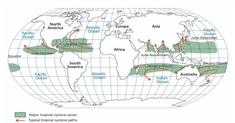
I. North Atlantic (The Hurricane Alley)
Regions : Caribbean Sea , Gulf of Mexico , and the eastern US Atlantic coast.
Peak Season : August to October .
Nomenclature : Known as Hurricanes .
Tracks : Typically track westward and northwestward, often making landfall along the US coast.
II. Indian Ocean (Bay of Bengal & Arabian Sea)
Regions : Bay of Bengal (BoB) and Arabian Sea .
Peak Seasons : Bifurcated— Pre-monsoon (May) and Post-monsoon (October–November), as the Inter-Tropical Convergence Zone (ITCZ) shifts over warm waters.
Indian Risk : BoB cyclones are more frequent (4x) and more destructive than Arabian Sea cyclones due to the shallow continental shelf, high river influx, and higher population density along the coast.
III. South Indian Ocean
Regions : East of Africa (from Madagascar and Réunion Islands) to 90°E longitude, and the Timor Sea in northwestern Australia.
Peak Season : January to March (Southern Hemisphere summer).
Impact : Affects East Africa (Mozambique, Tanzania) and Northwest Australia.
IV. North Pacific Ocean (Western Tropical Part)
Regions : Philippines , South China Sea , Taiwan, and Japan.
Peak Season : August to September .
Nomenclature : Known as Typhoons .
Record Holder : This basin records the maximum number of tropical cyclones worldwide, attributed to the vast expanse of warm water and favorable wind patterns.
V. North Pacific Ocean (Eastern Tropical Part)
Regions : Western coasts of Mexico, Central America up to the California coast.
Peak Season : August to October .
Nomenclature : Known as Hurricanes .
Movement : Most track westward into the open, colder Pacific, thus rarely affecting the California coast.
VI. South Pacific Ocean (Western Tropical Part)
Regions : East coast of Australia, Samoa, Fiji Islands , and the Coral Sea region.
Peak Season : January to March (Southern Hemisphere summer).
Nomenclature : Often referred to as Cyclones or Severe Tropical Cyclones (and Willy-Willies near Australia).
Missing Zone
Equator: Cyclones do not form between 0°–5° latitude due to the absence of the Coriolis force, which is necessary to induce cyclonic rotation.
| Region | Peak Season | Key Areas | Notes |
|---|---|---|---|
| North Atlantic | Aug–Oct | Caribbean, Gulf of Mexico, US Atlantic coast | Called Hurricanes |
| Indian Ocean | May, Oct–Nov | Bay of Bengal , Arabian Sea | Very destructive in South Asia; BoB is higher risk |
| North Pacific (West) | Aug–Sep | Philippines, S. China Sea, Japan | Highest cyclone frequency in the world ( Typhoons ) |
| North Pacific (East) | Aug–Oct | Mexico, Central America, California | Hurricanes in Eastern Pacific |
| South Indian Ocean | Jan–Mar | Madagascar, Réunion, Timor Sea | Affects East Africa, NW Australia |
| South Pacific (West) | Jan–Mar | Australia, Samoa, Fiji, Coral Sea | Summer cyclones common ( Willy-Willies ) |
Prelims tips
- North Pacific (western) records the highest number of tropical cyclones globally (Typhoons).
- Bay of Bengal cyclones are more frequent and destructive than Arabian Sea cyclones.
- Tropical cyclones do not form near the equator (0°–5°) due to the absence of the Coriolis force .
- The Indian Ocean has two peak seasons: Pre-monsoon (May) and Post-monsoon (Oct–Nov).
- The energy source is latent heat of condensation (thermal origin).
Mains points
- The Global distribution is unevenly concentrated in six main basins where warm water (SST > 26.5°C) and weak wind shear persist.
- The Bay of Bengal poses a high disaster risk due to funnel shape (magnifying storm surge), shallow water, and high coastal population density.
- Seasonality in cyclone formation is linked to the monsoon cycle in the Indian Ocean, contrasting with the single summer peak in the Atlantic.
- Climate change is increasing ocean heat content, which contributes to the rapid intensification and higher destructive potential of cyclones globally.
Structure and Life Cycle of a Tropical Cyclone
Tropical cyclones are intense low-pressure systems powered by latent heat of condensation over warm oceans. They consist of a central calm Eye , a violent Eyewall , and Spiral Rain Bands . Their life cycle includes initiation over warm seas, intensification with a distinct eye, and dissipation after landfall. They play a dual role: redistributing heat and moisture, but also causing large-scale destruction.
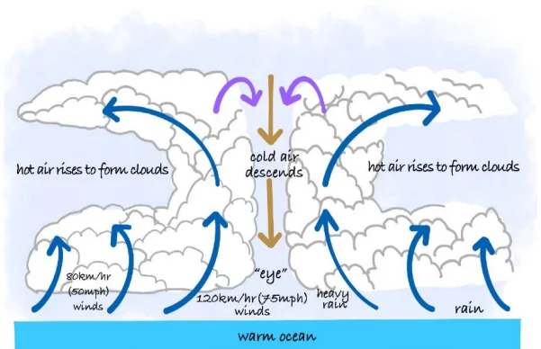
Vertical Structure of a Tropical Cyclone
Extends from the surface to the tropopause (~12–15 km).
Lower levels : Intense inflow of moist air spiraling inward, fueling the system.
Middle levels : Rising air with deep convection, massive cloud towers, and rapid condensation.
Upper levels : Strong outflow ( divergence ) of cold, dry air that acts as a 'ventilator' to maintain the central low pressure and cyclone strength.
Structure
Eye
The calm, clear, central core of the cyclone, characterized by sinking air (subsidence).
Diameter ranges from 10–50 km .
It is the zone of lowest pressure (can be as low as 880 mb in strongest cyclones).
Temperature inside the eye can be 5–10°C warmer than surrounding areas due to subsidence heating.
Eye Wall
The most dangerous part of the cyclone, encircling the eye.
Composed of towering cumulonimbus clouds rising up to 15 km.
Zone of extreme winds (150–300 km/h or more), torrential rainfall, and strongest convection.
Spiral Rain Bands
Bands of cumulonimbus and other clouds extending 100s of km outward .
Produce heavy rainfall, gusty winds, and localized tornado-like vortices.
Separated by 'rain-free' and relatively calmer zones in between bands.
Life Cycle
Early Stage (Formation)
Requires Ocean water temperature >27°C up to a depth of 60m to supply continuous moisture.
Coriolis effect initiates rotation (absent near equator within 5° latitudes).
Weak low-pressure disturbance intensifies into a tropical depression (winds < 63 km/h).
Latent heat of condensation acts as the primary energy engine.
Mature Stage (Intensification)
Characterized by a well-developed eye and organized cloud bands.
Peak wind speed exceeds 118 km/h (hurricane/severe cyclonic storm intensity).
Central pressure drops drastically, creating a steep pressure gradient and intense winds.
Storm surge is generated due to strong winds and low pressure, responsible for the heaviest damage.
Decay Stage (Dissipation)
Landfall cuts off the moisture supply; friction weakens the winds.
Moving over cold waters or encountering unfavorable wind shear can also dissipate the cyclone over the sea.
Eventually breaks down into a remnant low-pressure system or merges with other weather systems.
Hazards Associated with Tropical Cyclones
Storm Surge : The abnormal rise of sea water, often the most destructive component, causing coastal flooding.
Torrential Rainfall : Leads to widespread flooding and landslides.
High Velocity Winds : Cause structural damage, uproot trees, and damage infrastructure.
Secondary Hazards : Outbreaks of disease, massive agricultural loss, and human displacement.
| Part | Key Features | Hazards |
|---|---|---|
| Eye | Calm, clear, lowest pressure, warm core | None, deceptively calm |
| Eye Wall | Most intense winds & rainfall, towering clouds | Catastrophic winds, storm surge |
| Rain Bands | Spiral cloud bands, heavy rainfall zones | Flooding, tornado-like vortices |
| Stage | Features | Outcome |
|---|---|---|
| Early Stage | Warm ocean >27°C, rising moist air, Coriolis force | Depression forms |
| Mature Stage | Well-developed eye, eyewall, heavy rainfall, strong winds | Maximum destruction |
| Decay Stage | Landfall cuts moisture, friction increases, wind shear | System weakens & dissipates |
Prelims tips
- Cyclones are heat engines fueled by latent heat of condensation.
- The Eye is warm and calm (due to subsidence), but surrounded by the destructive eyewall .
- Storm surge is the deadliest hazard, not winds alone.
- Cyclones weaken rapidly after landfall due to cut-off moisture and friction.
- Coriolis force is essential: cyclones do not form within 5° of the equator.
Mains points
- Tropical cyclones are thermal-origin storms powered by warm oceans, transferring energy and moisture globally.
- The distinctive Structure (Eye, Eyewall) is a direct result of the pressure-wind-subsidence balance maintained by the latent heat release.
- The Decay Stage highlights the importance of the ocean surface; any change in SST or landfall leads to rapid dissipation.
- Effective Forecasting and Disaster Preparedness rely heavily on monitoring the central pressure drop and the associated storm surge prediction.
Types of Cyclones
Cyclones vary in intensity and structure, from weak tropical disturbances to devastating hurricanes. They develop under different oceanic and atmospheric conditions. A special type of cyclone, Medicanes , forms over the Mediterranean and shares hybrid features with tropical systems but is weaker and smaller.
Tropical Cyclones: Classification by Intensity (Saffir-Simpson Scale)
The Saffir-Simpson Hurricane Wind Scale is used primarily in the North Atlantic and East Pacific to categorize the intensity of cyclones from Category 1 to 5, based on sustained wind speeds.
Tropical Disturbance :
Migratory, wave-like low-pressure systems associated with easterly trade winds . They are characterized by disorganized convection and minimal closed circulation.
They generate positive relative vorticity (spin) which is often the precursor to stronger cyclones (e.g., Easterly waves over Atlantic).
Tropical Depression :
Small low-pressure centers, usually within the ITCZ (Intertropical Convergence Zone).
Sustained winds: less than 63 km/h . At this stage, the system achieves its first closed isobar.
Causes moderate rainfall, localized flooding.
Tropical Storm :
Organized low-pressure systems with sustained winds between 63–118 km/h.
Can cause heavy rainfall, flooding, and coastal inundation. Assigned official names by regional meteorological centers (e.g., IMD starts naming at this stage).
Hurricanes / Typhoons / Cyclones (Severe Cyclonic Storms):
Large-scale tropical cyclones with sustained winds exceeding 118 km/h.
Hazards: Storm surge (most destructive component), torrential rain, destructive winds.
Terminology: Hurricane (Atlantic & Eastern Pacific), Typhoon (Western Pacific & South China Sea), Cyclone (Indian Ocean & Australia).
Specialized and Hybrid Cyclone Types
Medicanes (Mediterranean Hurricanes) :
Definition: Rare, extra-tropical hurricanes observed over the Mediterranean Sea .
Hybrid Nature: Exhibit hybrid features—a structure similar to tropical cyclones (eye and eyewall) but deriving energy partly from baroclinic (frontal) influences common in temperate zones, and partly from warm water. This transition is known as tropical transition.
Characteristics: They are typically weaker and smaller (70–200 km) and short-lived (1–3 days). Their tracks are highly erratic.
Impact: Cause strong winds and flash floods around Mediterranean countries (e.g., Medicane Ianos, Greece, 2020).
Temperate Cyclones (Extratropical Cyclones) :
Formation: Formed by frontogenesis (interaction of polar and tropical air masses) in the mid-latitudes (35°–65°).
Energy Source: Potential energy from the horizontal temperature contrast (baroclinic instability).
Structure: They are asymmetrical with distinct warm and cold fronts.
Weather: Causes widespread, prolonged, gentler rain/snow (e.g., Western Disturbances in India).
General Characteristics
Coriolis Constraint: Cyclones do not form between 0°–5° latitude due to insufficient Coriolis force needed to induce cyclonic circulation.
Energy and Maintenance: Energy source for tropical systems is latent heat from warm water (SST > 26.5°C). The absence of vertical wind shear is critical for maintaining their vertical chimney structure.
| Feature | Tropical Cyclones | Medicanes |
|---|---|---|
| Occurrence | Warm tropical waters (Atlantic, Pacific, Indian Oceans) | Relatively warm Mediterranean waters (temperate zone) |
| Wind Speed | High (118 km/h or more) | Low to moderate (up to ~100 km/h) |
| Size | Large (160–600 km diameter) | Smaller (70–200 km diameter) |
| Duration | Up to 1–2 weeks | Short-lived (1–3 days) |
| Energy Source | Latent heat from deep warm oceans | Shallow warm waters + baroclinic influences |
| Impact | Storm surge , floods, widespread destruction | Localized flooding, coastal wind damage |
Prelims tips
- Cyclones are classified into disturbances, depressions, storms, and hurricanes based on wind speed.
- Official naming starts from the Tropical Storm stage (63 km/h).
- Medicanes are rare, hybrid, extra-tropical hurricanes forming over the Mediterranean.
- The Coriolis force absence near the equator prevents cyclone formation there.
- Hurricanes, Typhoons, and Cyclones are the same phenomena with different regional names.
Mains points
- Tropical cyclones evolve based on the continuous supply of latent heat , making their lifecycle dependent on ocean conditions.
- The intensity-based classification (Depression $ o$ Storm $ o$ Hurricane) is vital for early warning systems and differential disaster response.
- Medicanes represent a unique phenomenon where temperate zone factors (baroclinic instability) interact with warm surface water, highlighting the complexity of atmospheric hybrid systems.
- The uneven distribution (highest frequency in the NW Pacific) is key to understanding global patterns of disaster vulnerability.
Naming of Tropical Cyclones & Fujiwhara Effect
Tropical cyclones are named systematically by WMO regional bodies to avoid confusion and improve communication. An unusual and complex phenomenon, the Fujiwhara Effect , occurs when two cyclones come close enough to interact, sometimes merging into a single powerful storm or causing highly erratic, unpredictable tracks.
I. Naming of Tropical Cyclones (North Indian Ocean)
Purpose : Naming provides easy reference, enhances public awareness and preparedness, and avoids confusion if multiple cyclones occur simultaneously in the same region.
Regional Body : Naming is governed by the World Meteorological Organization (WMO) / UN Economic and Social Commission for Asia and the Pacific (ESCAP) Panel on Tropical Cyclones (PTC).
Indian Ocean Region : Naming started in the North Indian Ocean region in 2000. The list of names is maintained by the Regional Specialized Meteorological Centre (RSMC), New Delhi (India Meteorological Department - IMD).
Contributing Nations : The original 8 North Indian Ocean countries (India, Bangladesh, Maldives, Myanmar, Oman, Pakistan, Sri Lanka, Thailand) were later expanded to 13 (including Iran, Qatar, Saudi Arabia, UAE, and Yemen).
Procedure : Names are chosen to be short, easy to pronounce, and politically/culturally sensitive. They are used sequentially from the pre-agreed list, following an alphabetical order based on the names of the contributing countries.
Retirement of Names : Names of particularly destructive cyclones (e.g., Cyclone Fani, Tauktae) are retired and never reused to prevent insensitivity and historical confusion.
II. Fujiwhara Effect
Definition : It is the meteorological phenomenon where two tropical cyclones (or vortices) revolving in the same general direction come close enough (typically within 1,400 km of each other) to interact and orbit around a common center.
Origin : First observed in the Western Pacific (Typhoons Marie & Kathy, 1964) and named after the Japanese meteorologist Sakuhei Fujiwhara.
Outcome : The interaction causes unpredictable and rapid changes in intensity and direction, significantly complicating the tracking and forecasting of both storms.
Forecasting Challenge : The effect complicates warnings, as storms may deflect paths away from expected targets or accelerate rapidly toward the coast.
Factors Influencing Interaction : The relative intensity, size, and separation distance of the two vortices determine the exact nature of the interaction.
Five Interaction Types (Simplified)
Elastic Interaction (EI) : Storms deflect each other’s paths in a wide orbit without merging.
Partial Straining Out (PSO) : The smaller storm loses energy and partly dissipates.
Complete Straining Out (CSO) : The smaller storm fully dissipates, and the stronger storm absorbs its moisture and survives (occurs when strength is unequal).
Partial Merger (PM) : The smaller storm merges partially into the larger one, causing the larger storm to intensify slightly.
Complete Merger : Two storms of similar strength combine to form a single, much larger, and more powerful storm.
| Interaction Type | Description | Outcome |
|---|---|---|
| Elastic Interaction (EI) | Cyclones deflect each other's paths in a wide orbit. | No merger, altered tracks. |
| Complete Straining Out (CSO) | Smaller storm completely dissipates (if weaker). | Only stronger storm survives. |
| Complete Merger | Two storms of equal strength combine. | Formation of one powerful storm. |
| Partial Merger (PM) | Smaller storm merges partially into larger storm. | Larger storm intensifies slightly. |
| Partial Straining Out (PSO) | Smaller storm loses part of energy. | Weakened smaller storm. |
Prelims tips
- Cyclone naming in Indian Ocean started in 2000 .
- RSMC New Delhi maintains the name list for the North Indian Ocean, with 13 countries now contributing names.
- Fujiwhara Effect occurs if two cyclones are within 1400 km .
- The core outcome of the Fujiwhara Effect is orbital movement around a common center.
- The names of destructive cyclones are retired and never reused.
Mains points
- Cyclone naming is a crucial non-structural measure in disaster management , significantly improving hazard communication and governmental coordination.
- The Fujiwhara Effect poses a major challenge to current numerical weather prediction (NWP) models, as the sudden energy exchange and track changes are difficult to simulate accurately.
- Fujiwhara interactions can lead to rapid intensification or highly erratic tracks, increasing the vulnerability of coastal populations who receive conflicting warnings.
- The potential for climate change to increase the frequency of intense, slow-moving cyclones may lead to more frequent and prolonged Fujiwhara-type interactions.
Difference between Tropical and Temperate Cyclones
Tropical cyclones and temperate cyclones differ fundamentally in their origin, scale, energy source, and impact. While tropical cyclones are thermal systems fueled by latent heat over warm oceans, temperate cyclones are frontal systems formed by contrasting air masses in mid-latitudes .
Key Differences in Structure and Genesis
Origin Type : Tropical cyclones have a thermal origin , operating as heat engines fueled by water vapor. Temperate cyclones have a frontal (dynamic) origin , forming along the Polar Front.
Energy Source : Tropical cyclones derive energy from the latent heat of condensation (released from warm oceans, SST > 26.5°C). Temperate cyclones derive energy from the potential energy released by the horizontal temperature contrast between colliding air masses (baroclinic instability).
Location & Movement : Tropical cyclones are confined to the Tropics (5°–30° latitude) and move westward/poleward. Temperate cyclones occur in mid-latitudes (35°–65° latitude) and move west to east (Westerlies).
Formation Surface : Tropical cyclones form exclusively over warm oceans and decay over land. Temperate cyclones form over both oceans and continents.
Coriolis Force : The absence of sufficient Coriolis force is critical, preventing tropical cyclones from forming near the equator (0°–5°). Coriolis is essential for both types' rotation.
Differences in Scale and Impact
Size and Structure : Tropical cyclones are smaller (100–1000 km) but highly symmetrical, featuring a central Eye . Temperate cyclones are larger (500–2000+ km) and asymmetrical, defined by distinct Warm and Cold Fronts.
Wind Velocity : Tropical cyclones feature very high, violent, and destructive winds (>120 km/h) concentrated around the Eyewall. Temperate cyclones have moderate wind velocity (30–80 km/h) spread over a much larger area.
Duration : Tropical cyclones are generally short-lived, lasting up to 7–10 days (dissipating quickly after landfall). Temperate cyclones are long-lived, often persisting for 15–20 days or more.
Precipitation : Tropical cyclones bring intense, heavy rainfall over a localized area, coupled with catastrophic storm surges. Temperate cyclones cause widespread, gentler frontal rainfall and snow over a broad region.
| Aspect | Tropical Cyclones | Temperate Cyclones |
|---|---|---|
| Location | 5°–30° latitude (Tropics), over oceans only | 35°–65° latitude (Mid-latitudes), over oceans & land |
| Origin Type | Thermal (Latent Heat) | Frontal/Dynamic (Temperature Contrast) |
| Energy Source | Latent Heat from condensation (>26.5°C SST) | Potential Energy from frontal instability |
| Structure | Symmetrical, defined by central Eye and Eyewall | Asymmetrical, defined by Warm and Cold Fronts |
| Wind Speed | Very High (120–250+ km/h), catastrophic | Moderate (30–80 km/h) |
| Weather | Intense, heavy, localized rain; Storm Surge | Widespread, continuous, gentler rain/snow (frontal precipitation) |
| Movement | Westward/poleward (Trade Winds) | West to East (Westerlies) |
Prelims tips
- Tropical cyclones = thermal origin; Temperate cyclones = frontal origin (Polar Front Theory).
- The Eye (calm center) is a feature only of Tropical Cyclones.
- Tropical Cyclones do not form at the Equator due to lack of Coriolis force.
- Western Disturbances in India are examples of Temperate (Extratropical) Cyclones.
- Tropical cyclones intensify due to latent heat release ; Temperate cyclones intensify due to baroclinic instability.
Mains points
- The difference in energy source (latent heat vs. potential energy) dictates their impact: Tropical cyclones have concentrated, violent energy release, while Temperate cyclones have widespread, moderate energy release.
- Tropical cyclones pose a greater disaster management challenge for coastal, low-lying regions due to the lethal threat of storm surge.
- Temperate cyclones are crucial for the agricultural economy of mid-latitude regions (e.g., winter crops in North India) by providing widespread, sustained rainfall/snowfall.
- The lifecycle of Temperate cyclones involves frontogenesis, maturity, and occlusion, while Tropical cyclones have a simple life cycle of formation, intensification, and decay upon loss of warm water.
Anticyclones
Anticyclones are extensive high-pressure systems larger than mid-latitude cyclones, characterized by descending and diverging air . They bring stable weather conditions such as clear skies, dry air, and calm winds, but can occasionally lead to stagnation of air, causing fog and pollution buildup.
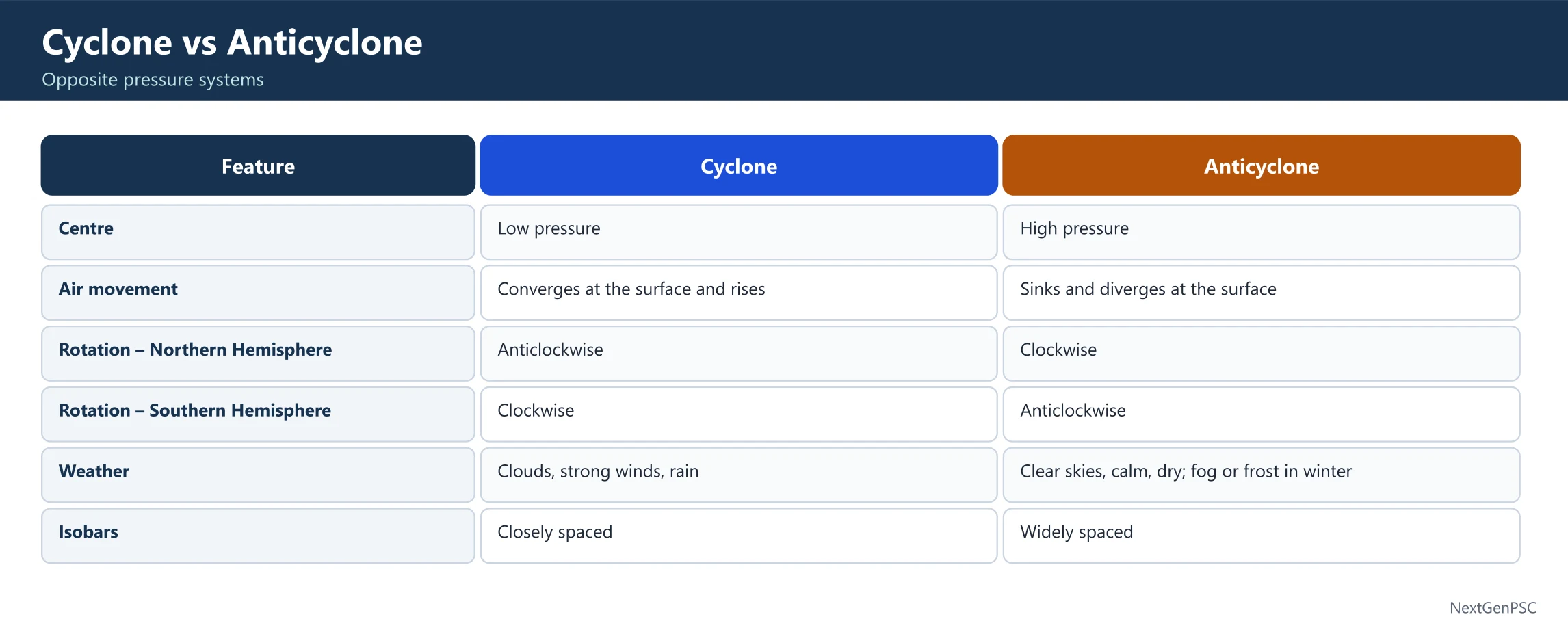
Salient Features and Dynamics of Anticyclones
Pressure Structure : They are large migratory high-pressure cells of the mid-latitudes, typically larger in horizontal extent than cyclones.
Vertical Movement : Air converges aloft (upper levels) and subsides downward (sinks), leading to adiabatic warming in the lower layers.
Surface Flow : The subsiding air diverges outward near the surface, leading to very limited wind movement near the center, but stronger winds outward.
Wind Direction : Winds flow outward due to the Coriolis Effect:
Northern Hemisphere (NH): Winds blow clockwise.
Southern Hemisphere (SH): Winds blow counterclockwise (anticlockwise).
Fronts : No air-mass conflict or fronts are associated with anticyclones, as the descending air prevents the convergence necessary for frontogenesis.
Weather : Characterized by clear skies, calm, and dry weather; the subsiding air compresses and warms, causing any clouds to evaporate, leading to stability.
Impact on Stability : They can stagnate over a region for days, maintaining prolonged dry conditions. This stability, especially in winter, leads to temperature inversion near the surface, trapping pollutants and causing severe fog and smog.
| Aspect | Cyclones | Anticyclones |
|---|---|---|
| Pressure Center | Low pressure at center | High pressure at center |
| Air Movement | Convergence at surface ( rising air ) | Divergence at surface ( sinking air ) |
| Hemisphere Flow (NH) | Anticlockwise (inward spiral) | Clockwise (outward spiral) |
| Associated Features | Fronts , rainbands, strong wind shear | No fronts , temperature inversion |
| Weather | Violent (heavy rain, floods, storms) | Stable (clear, dry, calm; fog/smog in winter) |
| Primary Hazard | Floods, storm surges | Drought, pollution stagnation |
Prelims tips
- Anticyclones are high-pressure systems characterized by descending air; they bring clear skies and dry weather.
- Winds in anticyclones blow clockwise in NH and anticlockwise in SH (outward spiral).
- Anticyclones contain no fronts , unlike temperate cyclones.
- Long-lasting winter anticyclones may cause temperature inversion leading to smog and fog.
Mains points
- Anticyclones play a crucial role in global circulation by balancing low-pressure systems and contributing to the global energy budget.
- They bring prolonged dry spells and clear skies, significantly influencing agriculture and water resource planning.
- Persistent winter anticyclones over continents (e.g., North India) lead to intense cold waves and the deadly accumulation of air pollution due to stability.
- Anticyclones over warm oceans (e.g., Subtropical Highs) are vital as they suppress tropical cyclone formation through divergence and high wind shear.
Thunderstorms
Thunderstorms are intense atmospheric circulations associated with cumulonimbus clouds , characterized by strong upward air movement, heavy rainfall, lightning , thunder, and sometimes hail. They form rapidly, evolve in distinct stages, and significantly influence local weather patterns.
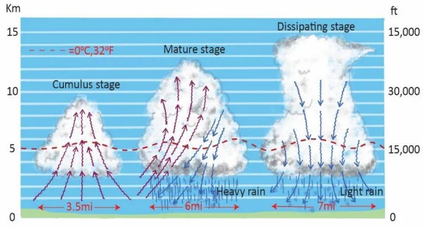
I. Structure and Life Cycle (Stages)
Associated Cloud : Thunderstorms are exclusively associated with massive, vertically developed Cumulonimbus (Cb) clouds , often reaching the tropopause (~12–15 km).
Convective Cells: They consist of one or more convective cells with strong vertical air movements.
Cumulus Stage (Growing) :
Dominated entirely by strong, sustained updrafts of warm, moist air rising from the surface (convergence).
The cloud grows rapidly; no precipitation reaches the ground yet.
Rising air releases latent heat, fueling intensification.
Mature Stage (Peak Intensity) :
Marked by the simultaneous presence of both strong updrafts and intense downdrafts (falling air carrying precipitation).
This is the stage of maximum intensity, featuring heavy rainfall, hail, powerful wind gusts, and frequent lightning and thunder.
Descending air creates a gust front on the surface, which can trigger new cell formation.
Dissipating Stage (Weakening) :
Downdrafts dominate, cutting off the supply of warm, moist air (the updraft) from the surface.
Precipitation tapers off, the cloud base weakens, and the storm dissipates.
II. Atmospheric Processes and Hazards
Lightning : Produced by the buildup of massive electrical potential difference (charge separation) between ice crystals and water droplets within the cloud, or between the cloud and the ground. The discharge neutralizes this electrical potential.
Thunder : Caused by the sudden, explosive expansion of air as it is instantaneously heated to over 30,000°C by the lightning bolt, creating a sonic shockwave.
Hailstorms : Occur when water droplets are repeatedly carried by strong updrafts above the freezing level and back down, adding layers of ice before falling.
Hazards : Primary hazards include flash floods (due to high-intensity rain), extensive crop damage (from hail), and may evolve into more severe local wind events like squalls (sudden, violent wind increase) or tornadoes (in mid-latitudes).
III. Global Distribution
Tropics (Hotspot) : Most common and frequent in equatorial and tropical regions (e.g., Congo, Amazon, Indonesia) due to intense surface heating and high moisture content (high CAPE—Convective Available Potential Energy).
Monsoon Regions : Frequent in monsoon regions like India and Southeast Asia during the summer months.
Mid-Latitudes : The USA's Great Plains (Tornado Alley) experiences the most severe types of thunderstorms globally due to the collision of contrasting air masses (cold/dry Polar air and warm/moist Gulf air).
Polar Regions : Rare due to the lack of sufficient solar heating and the inability to build up deep, moist convection.
| Stage | Characteristics | Weather Impact |
|---|---|---|
| Cumulus | Strong updraft , cloud formation begins, no precipitation | Cloud build-up, no rainfall |
| Mature | Updraft + downdraft , intense convection, highest lightning frequency | Heavy rain, hail, lightning, thunder |
| Dissipating | Downdrafts dominate , cuts off vertical air movement | Clouds weaken, rainfall ends, clear skies follow |
Prelims tips
- Thunderstorms are associated with Cumulonimbus clouds.
- Lightning is produced by charge separation; Thunder by rapid thermal expansion.
- The Mature Stage is the most intense, featuring both up and downdrafts.
- The USA's Tornado Alley is a global hotspot for severe thunderstorms that spawn tornadoes.
- In India, localized thunderstorms are known regionally as Nor'westers (Kalbaishakhi) and Mango Showers .
Mains points
- Thunderstorms are a direct result of atmospheric vertical instability (high CAPE) and the mechanism of latent heat release during condensation.
- The life cycle demonstrates the energy balance: updrafts fuel the system, and downdrafts lead to its eventual decay by cutting off the moisture supply.
- Hazards like lightning and hail have significant socioeconomic impact on agriculture and power grids , necessitating early warning systems.
- The presence of vertical wind shear often distinguishes ordinary thunderstorms from severe ones (which can produce tornadoes and squalls).
Tornadoes
Tornadoes are funnel-shaped storms with extremely low pressure at the center and the strongest surface winds on Earth, capable of reaching up to 500 km/h . They occur mostly in middle latitudes (25°–50°) during spring and summer, with the USA's Tornado Alley experiencing the maximum intensity.
I. Definition and Mechanism
Definition : A funnel-shaped, intensely violent storm characterized by a dark, rotating column of air extending from a cumulonimbus cloud to the ground.
Pressure Gradient : They possess the steepest pressure gradient in nature, resulting in the Earth's strongest measured winds (up to 500 km/h or more).
Mechanism : They form due to extreme vertical wind shear within a severe thunderstorm, causing the rotating horizontal air column to be tilted vertically by a powerful updraft, creating a rotating vortex (vorticity).
Direction : They generally move from southwest to northeast in the Northern Hemisphere.
II. Geographical Distribution
Latitudinal Range : Occur in middle latitudes (25°–50° N/S) , as this is where cold (Polar) and warm (Tropical) air masses frequently clash.
USA Hotspot : The USA (Tornado Alley), specifically the plains area from Texas to Nebraska, experiences the maximum frequency and intensity globally due to the collision of cP (cold, dry air from Canada) and mT (warm, moist air from the Gulf of Mexico).
Global Presence : Present on all continents except Antarctica. Other significant areas include Argentina, Australia, South Africa, and Bangladesh (which is the most susceptible region within the Indian subcontinent).
Seasonality : Most frequent during spring and early summer when temperature contrasts are sharpest.
III. Characteristics and Measurement
Wind Speed : Can reach up to 500 km/h , capable of lifting cars, structures, and heavy debris.
Duration and Path : Usually short-lived (minutes to an hour). Their path is narrow, generally a few hundred meters wide but can extend several km (up to 100 km).
Associated Weather : Always accompanied by severe thunderstorms, lightning, and hail.
Measurement : Intensity is measured using the Enhanced Fujita (EF) Scale, which rates the destruction caused on a scale from EF0 (minor) to EF5 (catastrophic).
IV. Waterspouts
Definition : Tornadoes occurring over the sea or oceans.
Nature : Common over warm tropical waters. They appear as rotating water columns with an intense vortex.
Strength : Generally weaker than land tornadoes but dangerous to ships, boats, and coastal areas.
| Feature | Tornadoes (Land) | Waterspouts (Sea) |
|---|---|---|
| Location | Over land (plains, valleys, storm-prone regions) | Over warm tropical oceans/seas |
| Wind Speed | Can exceed 400–500 km/h (Earth's strongest) | Generally weaker (mostly <150 km/h) |
| Mechanism | Associated with severe supercell thunderstorms | Associated with weaker thunderstorms or only cumulus clouds |
| Impact | Catastrophic (destruction of settlements, infrastructure) | Dangerous to ships, boats, and coastal regions |
| Measurement | Enhanced Fujita (EF) Scale | Usually measured visually or by wind estimates |
Prelims tips
- Tornado Alley in USA is the world’s most tornado-prone region.
- Tornado wind speeds can exceed 500 km/h , making them Earth’s strongest winds.
- Tornado intensity is measured using the Enhanced Fujita (EF) Scale .
- Waterspouts are tornadoes over warm tropical seas.
- The primary cause of tornadoes is vertical wind shear within a thunderstorm.
Mains points
- Tornadoes are the result of extreme atmospheric instability and vorticity (spin) generated by vertical wind shear within severe thunderstorms (supercells).
- They pose a unique disaster challenge due to their short duration and unpredictable path, requiring instantaneous warning systems (Doppler radar).
- The clustering of tornadoes in regions like Tornado Alley is explained by the favorable, persistent clash of contrasting air masses and flat topography.
- While short-lived, the economic and casualty impact of large tornadoes (EF4, EF5) is disproportionately high, necessitating robust building codes and preparedness.
Lightning
Lightning is a natural electrical discharge caused by charge separation within cumulonimbus clouds . It occurs when negative charges at the bottom of clouds connect with positive charges at the top or on the ground, producing a sudden flash of light and immense energy release.
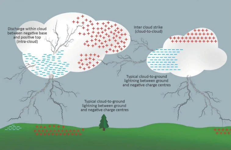
Formation Process (Triboelectrification)
Charge Generation : Collisions between heavy hail and lighter ice crystals inside cumulonimbus clouds generate static electricity ( Triboelectrification ).
Charge Separation : Negative charges (electrons) accumulate at the bottom of the cloud, while positive charges gather at the top .
Induced Charge : The negative cloud base induces a concentrated positive charge on the Earth’s surface directly below (on tall objects).
Discharge : When the intense electrical potential difference overcomes the air's resistance, the electrical discharge occurs as lightning, traveling via a stepped leader and return stroke.
Thunder : Caused by the sudden, explosive expansion of air after it is instantly heated to 30,000°C by the lightning bolt, creating a sonic shockwave.
Features and Classification
Extreme Heat : Lightning can reach temperatures up to 30,000°C —far hotter than the Sun's surface.
High Velocity : It can travel at speeds of up to 200,000 km/h .
Ecological Role : Lightning helps convert atmospheric nitrogen ( N2 ) into biologically useful compounds (nitrates), contributing to natural soil fertilization .
Cloud-to-Ground (CG) : Discharge between the cloud base and the Earth’s surface; the most dangerous and responsible for fatalities.
Intra-Cloud (IC) : Discharge occurring entirely within a single cloud ; the most common type.
Cloud-to-Cloud (CC) : Discharge between two separate clouds.
Ball Lightning : A rare phenomenon ; a glowing, spherical form of lightning.
Heat Lightning : Visible flashes without audible thunder, usually from distant storms (sound dissipates before reaching the observer).
| Type | Description | Danger Level |
|---|---|---|
| Cloud-to-Ground (CG) | Lightning strike between cloud and ground | Very High |
| Intra-Cloud (IC) | Within one cloud | Low |
| Cloud-to-Cloud (CC) | Between two clouds | Medium |
| Ball Lightning | Rare glowing ball of lightning | Unpredictable |
| Heat Lightning | Silent lightning from distant storms | Negligible |
Prelims tips
- Lightning forms due to charge separation in cumulonimbus clouds .
- Cloud-to-Ground (CG) lightning is the most dangerous type.
- Thunder results from rapid heating and expansion of air after lightning (sonic shockwave).
- Lightning plays an ecological role in fixing atmospheric nitrogen for soil fertility.
- The core process generating charge is Triboelectrification (friction between ice particles).
Mains points
- Lightning is a major atmospheric hazard that causes high annual fatalities in India, particularly in rural and agricultural regions.
- Understanding the precise mechanism of charge separation is crucial for developing effective early warning systems and lightning detection networks.
- The use of Lightning Arrestors (or rods) and modern building codes is essential for protecting infrastructure and reducing the risk of fire and electrical damage.
- Global warming may indirectly influence lightning frequency by increasing atmospheric instability and convection.
Indian & Physical Geography: All chapters
- The Universe and the Earth
- Atmosphere and Its Composition
- Atmospheric Temperature
- Atmospheric Moisture
- Air Mass, Fronts & Cyclones
- Evolution of Earth's Crust, Earthquakes and Volcanoes
- Interior of the Earth
- Landforms
- Geomorphic Processes
- Movement of Ocean Water
- Oceans and Their Properties
- Climate of a Region
- Indian Geography: Introduction and Geology
- Physiography of India
- Indian Climate
- Indian Drainage
- Soil and Natural Vegetation
- Mineral and Energy Resources, Industries in India
- Indian Agriculture
- Population, Migration and Urbanisation