
Indian & Physical Geography · UPSC Notes
Movement of Ocean Water — UPSC Geography Notes
Free, exam-focused notes for UPSC Prelims and Mains, with Prelims tips and Mains points for every topic. 17 topics.
Open in the interactive reader: bookmarks, progress tracking and read-aloud.
Movement of Ocean Water – Tides
The ocean acts like a giant liquid layer on Earth. Tides are the rhythmic rising and lowering of this water level, occurring twice a day. This happens because the Moon acts like a magnet pulling the water, and the Earth's rotation creates a force that pushes it back.
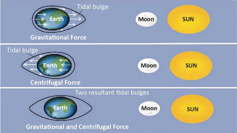
1. What exactly are Tides?
Imagine a glass of water. If you tilt it, water rises on one side and falls on the other. On Earth, gravitational forces 'tilt' the ocean water.
High Tide (Jwar): When the water level rises to its highest point and covers more of the beach.
Low Tide (Bhata): When the water recedes to its lowest point, exposing the seabed.
Tidal Range: The vertical difference in height between the High Tide and the Low Tide.
2. The Science: Why do they happen?
Two main forces work together to create tides:
A. Gravitational Pull (The Magnet):
The Moon is the main driver. Even though the Sun is bigger, the Moon is much closer, so its pull on oceans is 2.17 times stronger than the Sun's.
The Moon pulls the water on the side of Earth facing it, creating a Bulge (High Tide).
B. Centrifugal Force (The Spin):
Earth is spinning. Just like when you spin a bucket of water and the water pushes outwards, Earth's spin creates an outward force.
This force creates a second bulge on the opposite side of the Earth, away from the Moon. This ensures we have two high tides a day.
3. The Timing: Why not exactly 24 hours?
You might think tides happen at the same time every day, but they don't.
The Tidal Day: A tidal cycle takes 24 hours and 52 minutes.
Why the delay? While Earth rotates, the Moon also moves forward in its orbit. By the time Earth spins back to the same spot (24 hours later), the Moon has moved a bit further ahead. Earth takes an extra 52 minutes to catch up to the Moon's new position.
4. Types of Tides (Based on Sun-Moon Alignment)
The height of the tide changes depending on where the Sun, Moon, and Earth are standing.
A. Spring Tides (The Strongest Tides)
When: Full Moon (Purnima) and New Moon (Amavasya).
Alignment: The Sun, Moon, and Earth are in a Straight Line (called Syzygy).
Effect: The Sun and Moon pull together in the same direction. This creates the Highest High Tides and Lowest Low Tides (Maximum Tidal Range).
B. Neap Tides (The Weakest Tides)
When: 1st and 3rd Quarter of the Moon (Half Moon).
Alignment: The Sun and Moon are at Right Angles (90°) to each other.
Effect: The Sun's pull cancels out some of the Moon's pull (like a tug-of-war from sides). This creates Low High Tides and High Low Tides (Minimum Tidal Range).
5. Why are Tides Important?
Navigation: High tides raise water levels, helping big ships enter shallow harbors (e.g., Kandla Port and Diamond Harbour in India).
Fishing: Fish come closer to the shore during high tide to feed, helping traditional fishermen catch them easily.
Desilting: Tides rush in and out, naturally clearing mud and silt from river mouths (Estuaries), keeping them open for boats.
Energy: The strong force of moving tidal water can be used to generate electricity (Tidal Energy).
| Feature | Spring Tides (Dirgh Jwar) | Neap Tides (Laghu Jwar) |
|---|---|---|
| Position | Sun-Earth-Moon in Straight Line (180°) | Sun-Earth-Moon at Right Angle (90°) |
| Moon Phase | New Moon & Full Moon | 1st & 3rd Quarter |
| Tidal Range | Maximum (Very High Highs, Very Low Lows) | Minimum (Moderate tides) |
| Force | Constructive (Forces Add up) | Destructive (Forces Cancel out) |
Prelims tips
- Syzygy: The technical term for when the Sun, Earth, and Moon are in a straight line.
- Apogee vs Perigee: Tides are highest when the Moon is closest to Earth (Perigee - P for Pass/Near) and lower when it is farthest (Apogee - A for Away).
- Interval: Between a high tide and a low tide, there is a gap of approx 6 hours 13 minutes.
- Gulf of Khambhat: Has one of the highest tidal ranges in India.
Mains points
- Economic Geography: Discuss the role of tides in making riverine ports like Kolkata (Diamond Harbour) operational. Without tides, ships would get stuck in silt.
- Renewable Energy: Tides are a predictable source of energy. India has potential in the Gulf of Khambhat and Gulf of Kutch, though currently underutilized.
- Ecology: Tidal mixing is crucial for mangroves (Sundarbans). It brings nutrients from the sea and flushes out toxins from the fresh water.
Types of Tides (Based on Frequency)
Tides don't behave the same way everywhere. Some places see water rise twice a day, others only once. This classification is based on how many times high and low tides occur in a 24-hour period.
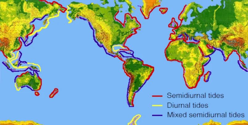
1. Semidiurnal Tide (The Regular Pattern)
What is it? 'Semi' means half. This pattern repeats every half-day.
Pattern: 2 High Tides + 2 Low Tides every 24 hours.
Height: The two high tides are roughly the same height.
Where: This is the most common type. Found along the Atlantic Coast (USA, Europe) and Indian Coast.
2. Diurnal Tide (The Daily Pattern)
What is it? 'Diurnal' means daily. This pattern happens only once a day.
Pattern: 1 High Tide + 1 Low Tide every 24 hours.
Where: Rare. Found in the Gulf of Mexico and parts of Southeast Asia.
3. Mixed Tide (The Uneven Pattern)
What is it? A mix of the two patterns above.
Pattern: 2 High Tides + 2 Low Tides, BUT they are of unequal heights.
Visual: Imagine having breakfast and dinner, but breakfast is a huge feast (High High Tide) and dinner is just a snack (Low High Tide).
Where: Pacific Coast of North America and many Pacific islands.
| Type | Frequency (per 24 hrs) | Key Feature |
|---|---|---|
| Semidiurnal | 2 High, 2 Low | Heights are equal |
| Diurnal | 1 High, 1 Low | Occurs once a day |
| Mixed | 2 High, 2 Low | Heights are unequal |
Prelims tips
- Semidiurnal tides are the most common type globally.
- Indian Coast: Generally experiences semidiurnal or mixed tides.
- Diurnal tides are rarer, mostly found in enclosed seas like the Gulf of Mexico.
Mains points
- Coastal Management: Knowing the frequency is vital for port authorities to schedule ship docking.
- Ecosystems: Intertidal zones (areas exposed during low tide) rely on this frequency for feeding cycles of crabs and birds.
Types of Tides (Based on Height)
The height of tides changes throughout the month. When the Sun and Moon pull together, tides are huge (Spring Tides). When they fight each other, tides are weak (Neap Tides). This cycle happens every month.
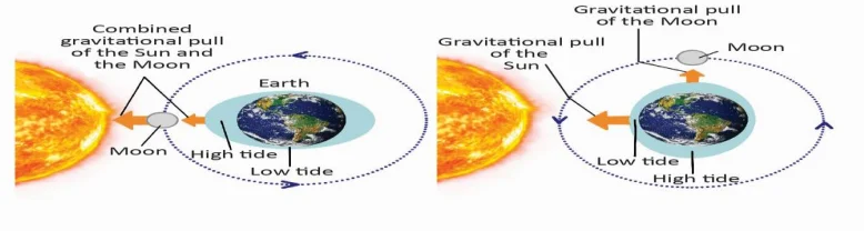
1. Spring Tides (The Strongest)
Don't get confused: 'Spring' has nothing to do with the season. It comes from the word 'springing forth' (jumping up).
When: Twice a month (New Moon & Full Moon).
Alignment: Sun, Moon, and Earth are in a straight line (called Syzygy).
Mechanism: The Sun helps the Moon. It's like two people pulling a rope in the same direction. ($1 + 1 = 2$).
Result: The water bulges significantly. High tides are very high; low tides are very low (Maximum Range).
2. Neap Tides (The Weakest)
When: Twice a month (1st and 3rd Quarter Moon - Half Moon).
Alignment: Sun and Moon make a 90° angle with Earth.
Mechanism: The Sun pulls water one way, the Moon pulls another way. They cancel each other out partially.
Result: The difference between high and low tide is very small.
3. Apogee and Perigee (Distance Matters)
The Moon's orbit is oval, not a perfect circle. Distance affects the pull.
Perigee (Near): Moon is closest to Earth. Tides are much higher. (Memory Tip: 'P' for Pass/Near).
Apogee (Far): Moon is farthest. Tides are lower. (Memory Tip: 'A' for Away).
| Feature | Spring Tide | Neap Tide |
|---|---|---|
| Moon Phase | Full / New Moon | Quarter Moon |
| Sun-Moon Angle | 0° or 180° (Straight) | 90° (Right Angle) |
| Tidal Range | Maximum (Extreme) | Minimum (Moderate) |
| Force | Additive (Combined) | Subtractive (Opposing) |
Prelims tips
- Frequency: There is a 7-day gap between a Spring Tide and a Neap Tide.
- Syzygy: Remember this term. It specifically refers to the straight-line alignment causing Spring Tides.
- Perihelion/Aphelion: Similarly, when Earth is closest to the Sun (Perihelion - Jan 3), solar tides are stronger.
Mains points
- Navigation Safety: Ships often wait for Spring Tides to enter shallow rivers (like the Hooghly in Kolkata) because the water level is higher.
- Energy Potential: Tidal power plants work best in areas with a large difference between high and low tides (High Tidal Range).
Tidal Bore & Significance of Tides
A Tidal Bore is a rare and powerful wall of water that travels up a river, against the river's natural flow. It happens when a massive high tide enters a narrow, shallow river mouth. Apart from this spectacle, tides are vital for the economy (ports, fishing) and the environment.
1. What exactly is a Tidal Bore?
Usually, rivers flow into the sea. A Tidal Bore is when the sea fights back and wins.
The Phenomenon: The incoming tide is so strong and fast that it pushes a vertical wall of water upstream into the river.
Visual: It looks like a surf wave traveling inland, sometimes for kilometers.
Sound: It makes a loud roaring sound (like a train approaching) because of the water crashing against the riverbed.
2. The "Funnel Effect": How does it form?
Not every river has a bore. Three specific conditions act like a funnel:
1. Narrow Mouth: The river mouth must be narrow. When the massive ocean tide enters, it gets squeezed, forcing the water level to rise instantly.
2. Shallow Depth: The river must be shallow. Friction with the riverbed slows down the bottom water, but the top water keeps moving fast, causing it to 'tumble' over and form a wave.
3. Extreme Tides: The difference between low and high tide must be very large (usually over 6 meters).
3. Why are Tides Important? (Significance)
Tides act like the heartbeat of the coast, regulating life and trade.
A. Navigation (Helping Ships)
The Problem: Big ships need deep water. Many river ports (like Kolkata or London) get shallow due to silt.
The Solution: Ships wait for High Tide. The tide acts like a water elevator, lifting the ship so it can safely enter the harbor.
B. Fishing Industry
Feeding Time: During high tide, ocean water rushes into creeks and inlets, bringing nutrients and small fish. Big fish follow them.
Catch: Fishermen can catch more fish near the shore during high tide without venturing into the dangerous deep sea.
C. Natural Cleaning (Desilting)
Rivers naturally deposit mud (silt) at their mouths, which can block them. Tides rush in and out with great force, scrubbing the river mouth clean and keeping it open.
D. Tides & Ecology
Mangroves: Forests like the Sundarbans survive because tides bring in salty ocean water and wash away plant waste daily.
Intertidal Zone: Creatures like crabs, oysters, and snails live in the zone that is wet during high tide and dry during low tide. They depend on this cycle for food.
| River | Location | Visual Feature |
|---|---|---|
| Qiantang River | China | Silver Dragon (9m high wall) |
| Amazon River | Brazil | Pororoca (Endless surfing wave) |
| Hooghly River | India | Bore tides help ships reach Kolkata |
| Normal River | Global | Water level rises slowly, no wave |
Prelims tips
- Bay of Fundy (Canada): Does NOT have a bore, but has the Highest Tidal Range in the world (water rises/falls by 16 meters!).
- Kandla & Diamond Harbour: These are Tidal Ports in India. They are dependent on high tides for operations.
- Tidal Energy: India is setting up tidal power plants in the Gulf of Khambhat and Gulf of Kutch (Gujarat) because of their favorable funnel shape.
Mains points
- Renewable Energy Potential: Tides are predictable (unlike wind or solar). Discuss how tidal barrages (dams) act like hydropower stations, using the rush of tide water to turn turbines.
- Salt Industry: In places like Gujarat, sea water enters salt pans during high tide. When the tide recedes, gates are closed, trapping the water. The sun then evaporates it to leave salt behind.
Ocean Currents: The Earth's Circulatory System
Ocean Currents are massive rivers flowing through the ocean. They are the reason why London is not as cold as Siberia, even though they are at similar latitudes. Currents transfer heat from the Equator to the Poles, keeping the Earth livable.
1. What are Ocean Currents?
Think of them as 'Rivers in the Sea'. They flow in a specific direction over long distances.
Surface Currents: Driven by Wind (Top 10% of ocean water).
Deep Currents: Driven by Density (Saltier/Colder water sinks). This is called Thermohaline Circulation.
2. Types of Currents (Temperature Based)
This is the most important classification for understanding climate.
A. Warm Currents (The Heaters)
Analogy: Like a hot water pipe running under the floor.
Movement: They flow from the Equator (Hot) towards the Poles (Cold).
Example: The Gulf Stream carries warm Caribbean water to Europe. This keeps European ports ice-free in winter.
Effect: They cause rainfall. Warm air holds moisture.
B. Cold Currents (The Coolers)
Analogy: Like an air conditioner blowing cold air.
Movement: They flow from the Poles (Cold) towards the Equator (Hot).
Example: The Peru (Humboldt) Current brings cold Antarctic water to South America.
Effect: They cause deserts. Cold air cannot hold moisture, so it doesn't rain over nearby land (e.g., Atacama Desert near Peru Current).
3. Forces: What makes them move?
Primary Forces (Start the movement):
1. Solar Energy (Heating): Water near the Equator heats up and expands. This makes the water level physically higher (about 8 cm) than at the Poles. Gravity pulls this water down the slope towards the poles.
2. Wind (Friction): Trade winds and Westerlies blow constantly across the ocean surface, dragging the water along with them.
3. Coriolis Force (The Spin): Because Earth spins, currents don't flow straight. They bend to the Right in the Northern Hemisphere and Left in the Southern Hemisphere.
Secondary Forces (Modify the path):
1. Landmasses: When a current hits a continent (like South America), it has to split and turn.
2. Salinity & Density: Saltier or colder water is heavier. It sinks down, pulling surface water in to replace it. This starts the deep ocean currents.
4. Gyres: The Giant Whirlpools
Because currents bend due to the Earth's spin (Coriolis effect) and hit continents, they form huge circular loops called Gyres.
There are 5 main Gyres in the world. They trap debris, forming things like the 'Great Pacific Garbage Patch'.
| Type | Examples | Region |
|---|---|---|
| Warm Current | Gulf Stream | North Atlantic |
| Warm Current | Kuroshio Current | North Pacific |
| Warm Current | Brazil Current | South Atlantic |
| Cold Current | California Current | Eastern Pacific |
| Cold Current | Humboldt/Peru Current | South America Pacific coast |
| Cold Current | Canary Current | Northwest Africa |
Prelims tips
- Fishing Zones: The best fishing grounds in the world are where Warm and Cold currents meet (e.g., Newfoundland and Japan coast). Why? Because mixing water brings food (plankton) to the surface.
- Sargasso Sea: A unique calm area in the North Atlantic Ocean with NO shores, surrounded entirely by currents.
- West Coast Rule: Almost all major hot deserts (Sahara, Atacama, Kalahari) are on the western side of continents because cold currents flow there.
Mains points
- Climate Change: If global warming melts polar ice, fresh water will dilute the salty ocean. This could stop the 'sinking' mechanism, shutting down the Global Conveyor Belt and freezing Europe (The 'Day After Tomorrow' scenario).
- Trade & Economy: Before engines, ships relied entirely on currents (Trade Winds & Currents) to travel between Europe, Africa, and Americas.
Atlantic Ocean Circulation (North Atlantic)
The North Atlantic circulation is a giant, clockwise-spinning loop (gyre) of ocean water. Think of it as a massive conveyor belt that moves warm tropical water towards Europe and brings cold polar water back towards the equator. This movement regulates the Earth's temperature.
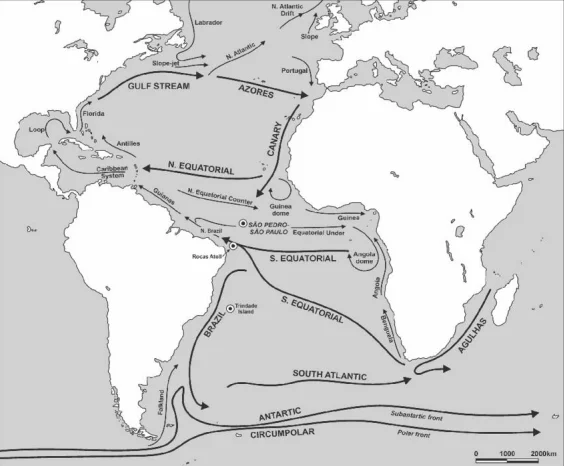
1. What is a Gyre?
A 'Gyre' is simply a large system of circulating ocean currents. The North Atlantic Gyre spins clockwise due to the Earth's rotation (Coriolis effect) and wind patterns.
2. The Engine: Equatorial Currents
Start Point: Near the Equator, the sun heats the water intensely.
Movement: The Trade Winds blow from east to west, pushing this warm water towards the Americas (North and South Equatorial Currents).
The Split: When this water hits Brazil, it splits. The northern part enters the Caribbean Sea, getting even warmer.
3. The River in the Ocean: Gulf Stream
As warm water piles up in the Gulf of Mexico, it is forced out through the narrow Florida Strait.
This creates the Gulf Stream, a powerful, fast-moving current (like a river flowing inside the ocean).
It hugs the US East Coast, carrying heat energy northward.
4. The Heat Pump: North Atlantic Drift
As the Gulf Stream moves east towards Europe, it widens and slows down, becoming the North Atlantic Drift.
Impact: It releases heat into the atmosphere. This is why London (Europe) creates mild winters, while places at the same latitude in Canada are freezing cold.
5. The Return Journey: Canary Current
After reaching Europe and Africa, the water cools down.
It turns southward along Northwest Africa as the Canary Current.
Desert Maker: This cold water cools the air above it, preventing cloud formation. This lack of rain is a major reason why the Sahara Desert exists nearby.
6. Cold Intruders from the North
Labrador Current: Flows south from the Arctic along Canada. Where this cold current meets the warm Gulf Stream (Grand Banks), it creates dense fog and one of the world's richest fishing grounds.
Irminger Current: Another cold branch near Iceland.
7. The Quiet Center: Sargasso Sea
In the middle of this spinning loop lies the Sargasso Sea.
It is a calm region with no coastlines, known for its distinct seaweed (Sargassum) and still waters.
| Current Name | Temperature | Key Role/Effect |
|---|---|---|
| Gulf Stream | Warm (Hot) | Moves heat from tropics to US & Europe. |
| North Atlantic Drift | Warm | Keeps European ports ice-free in winter. |
| Canary Current | Cold | Cools Africa; causes deserts (no rain). |
| Labrador Current | Cold (Icy) | Brings icebergs south (Titanic); creates fishing grounds. |
Prelims tips
- Sargasso Sea: The only sea without a land boundary; confined by currents within the North Atlantic Gyre.
- Fishing Grounds: The meeting point of the warm Gulf Stream and cold Labrador Current creates the 'Grand Banks' (rich in plankton and fish).
- Direction: Remember the gyre spins Clockwise in the Northern Hemisphere.
- Desiccation: Cold currents (like Canary) are usually found on the west coast of continents in mid-latitudes, causing deserts.
Mains points
- Climate Moderation: Explain how the North Atlantic Drift acts as a 'blanket' for Western Europe, allowing agriculture and habitation at high latitudes.
- Economic Impact: Discuss navigation (ice-free ports in Norway/UK) and fisheries (Grand Banks near Newfoundland).
- Climate Change Risk: If fresh water from melting Arctic ice stops the 'sinking' of water, this circulation could slow down, potentially freezing Europe (AMOC collapse theory).
- Aridity: Explain the link between the cold Canary current and the formation of the Sahara Desert due to lack of evaporation/moisture.
South Atlantic and Pacific Ocean Circulation
The South Atlantic circulation flows in an anti-clockwise direction (opposite to the North). The Pacific Ocean is much larger, containing two distinct systems: a clockwise loop in the North and an anti-clockwise loop in the South. These currents determine where deserts form and where the best fishing spots are located.
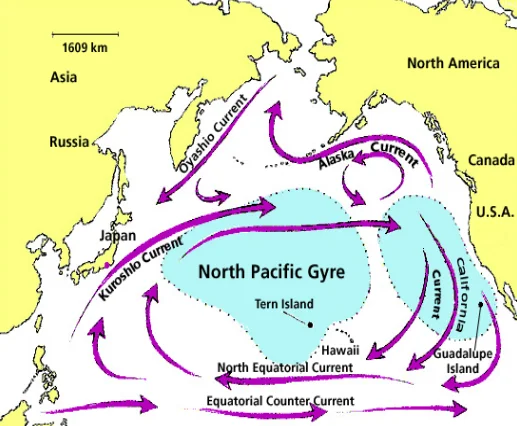
1. South Atlantic: The Anti-Clockwise Loop
Unlike the North Atlantic, the South Atlantic Gyre spins Anti-Clockwise because the Earth's rotation (Coriolis force) deflects wind and water to the left in the Southern Hemisphere.
2. The Journey of the Water (South Atlantic)
The Warm Start (South Equatorial Current): Driven by Trade Winds, warm water flows west along the Equator towards Brazil. Think of this as the start of the heating cycle.
The Warm Slide (Brazilian Current): Upon hitting Brazil, the water turns south. This warm water acts like a heater for the Brazilian coast, bringing humidity and rain.
The Cold Connector (South Atlantic Current): As it goes further south, it hits the 'West Wind Drift' (freezing Antarctic water), turns east, and cools down significantly.
The Cold Return (Benguela Current): This cold water flows up along the west coast of Africa to complete the circle.
Key Fact: Cold water does not evaporate easily. Because the Benguela current is so cold, it creates very little rain. This is why the dry Namib Desert exists right next to the ocean.
3. Pacific Ocean: The Giant System
The Pacific is so wide that its currents form two separate huge loops. It covers nearly one-third of the Earth's surface, making its circulation vital for the whole planet's weather.
4. North Pacific (Clockwise Gyre)
Kuroshio Current (The 'Black Tide'): This is the Pacific's version of the Gulf Stream. It is a warm, fast current flowing north past Taiwan and Japan, bringing heat to the region. It is dark blue in color, hence the name.
North Pacific Drift: The water moves east towards North America. It acts as a barrier separating polar water from tropical water.
California Current: A cold current flowing south along the US West Coast. This cool water is why beaches in California are often foggy and chilly, and why the nearby land is dry (contributing to deserts like Mojave).
Oyashio Current: A cold current coming from the freezing Bering Sea. It meets the warm Kuroshio near Japan. Tip: Where warm and cold water meet, it creates a nutrient explosion, making it one of the world's best fishing grounds.
5. South Pacific (Anti-Clockwise Gyre)
East Australian Current: Made famous by the movie 'Finding Nemo', this warm current flows south along Australia's east coast, bringing warm water to places like Sydney.
Peru (Humboldt) Current: A massive cold current flowing north along South America (Chile/Peru). It is one of the most important currents for marine life.
The 'Upwelling' Effect: As this current moves, it pulls deep, nutrient-rich cold water to the surface. Fish love these nutrients, making the coast of Peru a global fishing hub.
6. The Balancer: Equatorial Counter Current
Because strong winds pile up so much water in the western Pacific (near Indonesia), the sea level is actually higher there. Gravity pulls some of this water back towards the east. This 'backflow' runs right along the Equator.
| Current | Ocean | Type | Region/Direction |
|---|---|---|---|
| Brazilian Current | South Atlantic | Warm | South along Brazil |
| Benguela Current | South Atlantic | Cold | NW along SW Africa |
| South Atlantic Current | South Atlantic | Warm | Eastward with Westerlies |
| South Equatorial Current | South Atlantic | Warm | Westward along Equator |
| Kuroshio Current | North Pacific | Warm | North along Japan |
| California Current | North Pacific | Cold | South along N. America |
| Oyashio Current | North Pacific | Cold | South from Bering Sea |
| East Australian Current | South Pacific | Warm | South along Australia |
| Peru (Humboldt) Current | South Pacific | Cold | North along S. America |
| Equatorial Counter Current | Pacific | Warm | Eastward along Equator |
Prelims tips
- Rule of Thumb: In the Southern Hemisphere, gyres always flow Anti-Clockwise.
- The Desert Connection: If you see a desert on the west coast of a continent (like Atacama or Namib), there is always a Cold Current nearby.
- Fishing Trick: Cold water brings food (nutrients) from the bottom. Therefore, cold currents (like Humboldt and Benguela) = Rich Fisheries.
- Kuroshio vs Oyashio: Think of Kuroshio as the 'Warm Japanese river' and Oyashio as the 'Cold Arctic Ghost'.
Mains points
- Economic Geography: Explain why the economies of Peru and Namibia rely heavily on fishing exports (due to Cold Currents/Upwelling).
- Climate Extremes: Discuss how the Peru Current creates the Atacama Desert (driest place) versus how the Brazil Current supports rainforests.
- El Niño Impact: Mention that during El Niño, the cold Peru current gets replaced by warm water, which destroys the local fishing industry and changes global rain patterns.
- Comparison: You may be asked to compare the North Atlantic (Gulf Stream) with the North Pacific (Kuroshio)—both serve as 'heat pumps' for the northern hemisphere.
Indian Ocean Circulation
The Indian Ocean is unique because it is 'closed' on the northern side by Asia. While the South Indian Ocean follows a steady circular path like other oceans, the North Indian Ocean changes its current direction entirely every season due to the Monsoon winds.
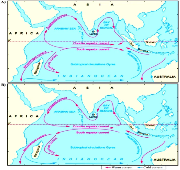
1. South Indian Ocean (The Steady Loop)
The southern part acts like a normal ocean because it is open and wide. The currents here form a permanent Anti-Clockwise loop (gyre), just like in the South Atlantic and Pacific.
South Equatorial Current (The Engine): Driven by the Trade Winds, a massive stream of warm water flows from Australia towards Africa (East to West) along the Equator. This piles up warm water near Africa.
Agulhas / Mozambique Current (The Warm River): When this water hits the African coast and Madagascar, it is forced south. It flows down the east coast of Africa as a narrow, fast, and warm current. It brings humidity and storms to the region.
West Wind Drift (The Cold Connector): As the current reaches the bottom of Africa, it meets the freezing waters of the Antarctic. It turns east, driven by the strong westerly winds.
West Australian Current (The Cooler): To finish the loop, cold water flows north along the west coast of Australia. This cold water cools the air, preventing rain, which is why Western Australia has large deserts.
2. North Indian Ocean (The Shifting System)
This is the only ocean in the world where currents reverse direction twice a year. This happens because of the Monsoon (seasonal winds). The land mass of Asia heats up and cools down much faster than the ocean, acting like a giant pump.
A. Summer: The South-West Monsoon (June–Oct)
The Heating Effect: In summer, the Asian landmass gets very hot. Hot air rises, creating a vacuum (Low Pressure). This pulls wind from the ocean towards the land.
Current Flow: The wind pushes the water in a Clockwise direction.
Somali Current (The Exception): Usually, currents on the east side of continents are cold. However, in summer, the wind pushes water so hard that the Somali Current becomes a strong, Warm current flowing North along East Africa.
B. Winter: The North-East Monsoon (Dec–Mar)
The Cooling Effect: In winter, the Asian landmass gets very cold. The air creates high pressure and pushes wind away from the land towards the ocean.
Current Flow: The wind pushes the water in an Anti-Clockwise direction.
Reversal: The currents that were flowing towards India in summer now turn around and flow away towards Africa.
3. Why is this Significant?
The Monsoon Engine: These currents are essential for the Indian Monsoon. The warm water moving towards India in summer supplies the moisture needed for the rains that feed billions of people.
Agulhas Leakage: The Agulhas current is so fast that some of its warm water 'leaks' around the tip of Africa into the Atlantic Ocean. This transfer of heat is crucial for balancing the global climate.
Historical Trade: Ancient sailors (like Arab traders) used these predictable current changes to sail easily between Africa and India—riding the wind one way in winter and returning in summer.
| Current Name | Type (Warm/Cold) | Key Behavior/Fact |
|---|---|---|
| Agulhas Current | Warm | Fast current south of Africa; brings storms. |
| West Australian | Cold | Causes dry deserts in Western Australia. |
| Somali Current | Unique | Reverses direction seasonally (Summer=North, Winter=South). |
| North East Drift | Cold (Winter) | Flows away from India (Oct-Dec). |
| South West Drift | Warm (Summer) | Flows towards India; brings rain (June-Sept). |
Prelims tips
- Unique Feature: If asked which ocean has 'Reversing Currents', the answer is always Indian Ocean.
- Agulhas vs Benguela: Don't confuse them. Agulhas is on the East of Africa (Warm/Indian Ocean), Benguela is on the West of Africa (Cold/Atlantic Ocean).
- Direction Trick: In Winter (North-East Monsoon), currents flow Anti-Clockwise. In Summer (South-West Monsoon), currents flow Clockwise.
- No Sargasso Sea: The Indian Ocean does NOT have a Sargasso Sea because its northern gyre is not stable (it keeps reversing).
Mains points
- Monsoon Dependency: Explain how the reversal of currents is driven by the differential heating of land (Asia) and sea (Indian Ocean). This is the 'engine' of the South Asian climate.
- Economic Importance: Discuss how the Somali current upwelling supports fisheries in East Africa, and how historical trade routes (Spice Route) relied on these predictable currents.
- Climate Balance: Mention 'Agulhas Leakage'—the movement of warm Indian Ocean water into the Atlantic. This heat transfer helps drive the global ocean conveyor belt, affecting weather as far away as Europe.
Important Warm Ocean Currents
Warm currents are generally western boundary currents that transport warm water from equatorial to higher latitudes, moderating climate and influencing rainfall patterns.
| Current | Ocean/Region | Key Facts |
|---|---|---|
| North Equatorial Current | Pacific & Atlantic | Flows east → west between 10°N and 20°N; forms southern side of subtropical gyres. |
| Kuroshio Current | Pacific | ‘Black Stream’; warm western boundary current, regulates Japan’s temperature; similar to Gulf Stream. |
| North Pacific Current | Pacific | Clockwise circulation in W. North Pacific; formed by Kuroshio & Oyashio convergence. |
| Alaskan Current | North Pacific | Northward diversion of North Pacific Current; creates Haida & Sitka eddies. |
| Equatorial Counter Current | Atlantic, Pacific, Indian | Flows west → east between 3°N and 10°N; wind-driven counter flow. |
| Tsushima Current | Sea of Japan | Branch of Kuroshio Current, flows into Sea of Japan. |
| South Equatorial Current | Atlantic, Pacific, Indian | East → west flow in Southern Hemisphere; driven by trade winds. |
| East Australian Current | South-West Pacific | Transports tropical marine fauna to subtropical SE Australia. |
| Florida Current | S. Atlantic & Caribbean | Discovered in 1513; flows around Florida Peninsula, joins Gulf Stream. |
| Gulf Stream | North Atlantic | Powerful western boundary current; splits into North Atlantic Drift & Canary Current. |
| Norwegian Current | North Sea & Barents Sea | Branch of North Atlantic Drift; carries warm water into Arctic. |
| Irminger Current | North Atlantic | Named after Carl Irminger; part of subpolar gyre, moderates Iceland-Greenland seas. |
| Antilles Current | North Atlantic | Flows across islands separating Atlantic & Caribbean; part of N. Atlantic gyre. |
| Brazilian Current | South Atlantic | Flows south along Brazil coast; meets Falkland Current at Rio de la Plata. |
| Mozambique Current | Indian Ocean | Flows in Mozambique Channel between Mozambique & Madagascar; forms large eddies. |
| Agulhas Current | SW Indian Ocean | Largest western boundary current; flows south along E. Africa. |
| Southwest Monsoon Current | North Indian Ocean | Seasonal; flows NE in Arabian Sea & Bay of Bengal (June–Oct). |
Prelims tips
- Western boundary currents (e.g., Gulf Stream, Kuroshio, Agulhas) are stronger, warmer, and faster than eastern boundary currents.
- Equatorial Counter Current is an exception as it flows eastward against trade winds.
- Brazil Current (warm) meets Falkland Current (cold) at Rio de la Plata → rich fishing grounds.
- Southwest Monsoon Current is unique to Indian Ocean due to monsoonal reversal.
Mains points
- Warm ocean currents transport heat poleward, moderating coastal climates.
- They influence rainfall, cyclones, and fisheries (e.g., Gulf Stream warms Europe, Brazil Current meets Falkland → rich fisheries).
- Indian Ocean monsoon currents highlight the unique ocean-atmosphere interaction in South Asia.
- Western boundary currents are more significant in global thermohaline circulation.
Important Cold Ocean Currents
Cold currents flow from higher latitudes (polar/sub-polar regions) towards the equator, bringing nutrient-rich waters that support some of the richest fisheries in the world.
| Current | Ocean/Region | Key Facts |
|---|---|---|
| Canary Current | North Atlantic | Eastern boundary current; flows south along NW Africa; cools regions like Morocco; supports upwelling & fisheries. |
| Labrador Current | North Atlantic | Cold current flowing south between Greenland & Canada; meets Gulf Stream, creating foggy Grand Banks (rich fishing). |
| Oyashio Current | NW Pacific | Cold subarctic current flowing south from Bering Sea along Russia/Japan; meets warm Kuroshio → fog & rich fisheries. |
| California Current | NE Pacific | Eastern boundary current; flows south along US West Coast; cools California climate; upwelling zone → sardine fisheries. |
| Benguela Current | SE Atlantic | Flows north along SW Africa; cold upwelling zone supports rich fisheries (Namibia, South Africa). |
| Peru (Humboldt) Current | SE Pacific | Cold current along west coast of South America; rich in plankton; supports world’s largest anchovy fisheries; linked to El Niño. |
| Falkland Current | SW Atlantic | Cold current flowing north along east coast of S. America; meets Brazil Current near Rio de la Plata. |
| West Australian Current | Indian Ocean | Flows northward along western Australia; cooler current influencing desert climate (Perth region). |
| West Wind Drift | Southern Ocean | Largest current; flows endlessly east around Antarctica; mixes with other cold currents. |
Prelims tips
- Cold currents generally flow along the western coasts of continents in low & mid-latitudes.
- Peru (Humboldt) Current is one of the world’s richest fishing grounds but collapses during El Niño.
- Mixing of warm & cold currents (e.g., Labrador + Gulf Stream, Oyashio + Kuroshio) creates fog and boosts fisheries.
- West Wind Drift is the only current that flows unimpeded around the globe.
Mains points
- Cold currents bring nutrient-rich waters → basis for some of the world’s richest fisheries (Peru, Benguela, California).
- They influence coastal climates (e.g., Atacama Desert linked to Peru Current, Namib Desert linked to Benguela Current).
- Convergence of warm and cold currents creates fog and hazardous navigation but boosts biodiversity.
- Play a critical role in El Niño–Southern Oscillation (ENSO) and global climate regulation.
Significance of Ocean Currents
Ocean currents act as a global conveyor belt. Just as blood circulates in the human body to regulate temperature and transport nutrients, ocean currents circulate around the Earth to balance heat, feed marine life, and shape the weather.
1. The Earth's Thermostat (Heat Balance)
The Equator is very hot, and the Poles are freezing. If currents didn't move, the Equator would get hotter and the Poles colder.
How it works: Warm currents take excess heat from the Equator to the Poles. Cold currents bring cooling water back to the Equator. This keeps the Earth habitable.
2. The 'Buffet' for Fish (Fishing Grounds)
The best places in the world to catch fish are where a Warm Current meets a Cold Current.
Why? Cold water brings food (nutrients) from the deep. Warm water provides a comfortable temperature. This creates an explosion of plankton (fish food).
Example: The Grand Banks near Canada is a world-famous fishing zone because the cold Labrador Current meets the warm Gulf Stream there.
3. Upwelling: Bringing Food to the Surface
Sometimes, wind pushes surface water away, allowing deep, cold, nutrient-rich water to rise up to replace it. This process is called Upwelling.
Impact: This deep water is full of 'fertilizer' for the ocean. This is why the coast of Peru (Humboldt Current) has so many fish.
4. Influencing the Weather (Rain vs. Deserts)
Warm Currents = Rain: Warm water evaporates easily, creating clouds and rain (e.g., Brazil, Japan, UK).
Cold Currents = Deserts: Cold water chills the air, preventing clouds from forming. This creates dry conditions.
Fact: Most big deserts (Sahara, Atacama, Namib) are located on the West Coast of continents where cold currents flow.
5. Navigation and Trade
Currents are like 'moving walkways' for ships. Historically, sailors used them to travel faster and save fuel. If a ship travels with the current, it moves much faster.
6. Marine Highways
Animals like turtles, whales, and eels use currents to migrate thousands of miles without using much energy. They ride the currents like a highway.
| Interaction | Result/Phenomenon | Real World Example |
|---|---|---|
| Warm Current + Cold Current | Fog & Fish: Creates thick fog (danger for ships) but lots of fish. | Newfoundland (Grand Banks) |
| Cold Current near Coast | Deserts: Dries out the air, creating coastal deserts. | Atacama Desert (Peru Current) |
| Warm Current near Coast | Mild Climate: Makes winters warmer than usual. | UK/Europe (North Atlantic Drift) |
| Upwelling (Deep water rising) | Fertilizer: Brings nutrients up; fishing boom. | Coast of Peru |
Prelims tips
- Desiccating Effect: If the question asks why deserts form on the West coast of continents in the subtropics, the answer is usually 'Cold Ocean Currents'.
- Grand Banks Fog: The fog here is famous not just for weather, but because it hides icebergs (like the one that sank the Titanic).
- Sargasso Sea: This is a unique habitat created bycurrents (a gyre), but it has no currents inside it (it's still water).
- Fishing Economics: Countries with 'Upwelling' zones (like Peru) are major exporters of fish meal and fertilizer.
Mains points
- Climate Change Connection: Discuss how melting ice (fresh water) could stop the 'Heat Balance' system (AMOC), leading to freezing winters in Europe.
- Economic Geography: Explain the location of major fishing industries (Japan, Newfoundland, Peru) based on current convergence and upwelling.
- Navigation Safety: While currents help speed, the mixing zones create fog and icebergs, posing major risks (Case study: Titanic).
- Ecosystem Services: Currents don't just move water; they move larvae, eggs, and nutrients, connecting ecosystems across the globe.
Ocean-Atmospheric Interactions: El Niño & Southern Oscillation (ENSO)
Think of El Niño as a 'fever' for the Pacific Ocean. It is a climate pattern where the water in the central and eastern Pacific gets unusually warm. This warmth changes wind patterns, causing floods in some places (like Peru) and droughts in others (like India and Australia).
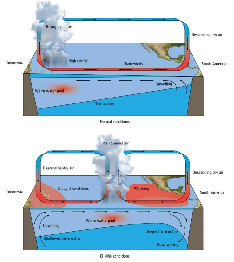
1. What is the 'Normal' Condition? (Walker Circulation)
To understand El Niño, you first need to know what happens normally in the Pacific Ocean.
Wind Flow: Strong Trade Winds blow from East (Americas) to West (Australia). Imagine a giant fan blowing across the ocean.
The Piling Up: These winds push warm surface water towards Australia and Indonesia. This creates a large pool of warm water there.
The Rain: Warm water evaporates and creates clouds. So, Australia and Indonesia usually get plenty of rain and have lush forests.
The Cold Coast: Near Peru (South America), the wind pushes the surface water away. To fill the gap, cold, nutrient-rich water from the deep ocean rises to the top. This is called Upwelling. Fish love this cold water.
2. What happens during El Niño? (The Disruption)
Every 2 to 7 years, this system gets disrupted.
Weak Winds: The Trade Winds get tired and weaken (or sometimes even reverse direction).
The Slosh Back: Since the wind isn't pushing hard enough to keep the water in the West, the warm water flows back towards South America (East).
The Result: Now, the East Pacific (Peru) is warm, and the West Pacific (Australia) is cooler than usual. The system has flipped.
3. The Consequences (The Weather Flip)
Because the warm water moved, the rain moves too.
Peru/Ecuador (Floods): They get the warm water and the rain clouds. Deserts can turn into lakes, causing massive floods. (This is bad for fishing because the cold nutrient water stops rising).
Australia/Indonesia (Droughts): They lose the warm water and clouds. This leads to severe droughts and often causes massive forest fires.
India (Weak Monsoon): The global wind system is connected. El Niño often suppresses the monsoon winds that bring rain to India, leading to less rainfall and potential drought.
4. What is the 'Southern Oscillation'?
While El Niño is about the Ocean (temperature), Southern Oscillation is about the Atmosphere (pressure).
The Seesaw: It is a 'seesaw' of air pressure. When pressure is high over the Pacific, it is low over the Indian Ocean, and vice versa.
Connection (ENSO): When the Ocean gets warm (El Niño), the Pressure patterns flip (Southern Oscillation). Because they happen together, scientists call the whole phenomenon ENSO.
| Feature | Normal Year | El Niño Year |
|---|---|---|
| Warm Water Location | Near Australia (West) | Near Peru (East) |
| Rainfall Location | Australia & Asia (Good Rain) | Central Pacific & Peru (Floods) |
| Fishing in Peru | Excellent (Cold water brings food) | Poor (Warm water kills nutrients) |
| Impact on India | Normal Monsoon | High risk of Drought |
Prelims tips
- Definition Trap: El Niño is the Warm phase. La Niña is the Cold phase. Don't mix them up.
- The Name: 'El Niño' means 'Little Boy' (Christ Child) because it usually appears around Christmas.
- Measurement: Scientists use the SOI (Southern Oscillation Index). Negative SOI usually means El Niño is happening.
- Geography: It happens in the Pacific Ocean, but it affects the whole world (Global Teleconnections).
Mains points
- Agriculture vs. Fisheries: Explain the paradox—while Peruvian fishermen suffer (no fish), Indian farmers suffer (no rain).
- Disaster Management: Discuss how El Niño forecasting helps governments prepare for droughts (stockpiling food) or floods.
- Climate Change: Mention that global warming might be making El Niño events more frequent and more intense.
- Economic Impact: It causes billions of dollars in losses due to crop failures in Asia and flood damages in the Americas.
Consequences of El Niño
El Niño acts like a global weather disruptor. Because the 'heat center' of the ocean shifts from Australia to South America, the rain follows the heat. This causes Floods in the deserts of Peru and Droughts in the rainforests of Indonesia and Australia.
1. Pacific Region (The Center of Action)
The Shift: Normally, trade winds push warm water to Australia. During El Niño, winds weaken, and warm water sloshes back to the Central & East Pacific.
South America (Peru/Ecuador): The arrival of warm water creates massive rain clouds. Result: Heavy Floods in usually dry areas.
Australia & Indonesia: The warm water (and rain) leaves this region. Result: Severe Droughts, forest fires, and water shortages.
2. Marine Ecosystems (The Food Chain Crash)
The Fertilizer Problem: Normally, cold water rises up near Peru carrying nutrients (fish food). This is called Upwelling.
The Collapse: El Niño's warm water acts like a lid, blocking this cold water. Without nutrients, Phytoplankton (tiny plants) die. Without plants, small fish (Anchovies) die or migrate. This crashes the fishing industry.
3. India & Monsoon (The Teleconnection)
The Link: The global wind system is connected. When it rains heavily in the Pacific (Chile/Peru), the air circulation suppresses the winds over the Indian Ocean.
Impact: This leads to a Weak Monsoon in India. Farmers suffer because crops like Rice (Paddy) need plenty of water.
4. Cyclones & Storms (The Trade-off)
Pacific Ocean: Since the water is warmer, there is more energy for storms. Result: More Cyclones/Typhoons.
Atlantic Ocean: El Niño creates strong winds in the upper atmosphere (wind shear) that rip storms apart. Result: Fewer Hurricanes in the US/Atlantic.
5. North America (Distant Effects)
Warmer North: Canada and Northern US experience milder, warmer winters (less snow).
Wetter South: The Southern US gets more rain and storms than usual.
| Region | What Happens? | Why? |
|---|---|---|
| Peru & Ecuador | Floods & No Fish | Warm water arrives here, bringing rain but killing nutrients. |
| Australia & Indonesia | Drought & Fire | Warm water (rainmaker) moves away from here. |
| India | Weak Monsoon | Atmospheric pressure changes suppress rain clouds over India. |
| Atlantic Ocean | Fewer Hurricanes | Strong upper winds tear storms apart before they grow. |
| Pacific Ocean | More Cyclones | Warmer water provides fuel for storms. |
| Region | What Happens? | Why? |
|---|---|---|
| Peru & Ecuador | Floods & No Fish | Warm water arrives here, bringing rain but killing nutrients. |
| Australia & Indonesia | Drought & Fire | Warm water (rainmaker) moves away from here. |
| India | Weak Monsoon | Atmospheric pressure changes suppress rain clouds over India. |
| Atlantic Ocean | Fewer Hurricanes | Strong upper winds tear storms apart before they grow. |
| Pacific Ocean | More Cyclones | Warmer water provides fuel for storms. |
Prelims tips
- The Rule: El Niño generally means Less Rain for India and Australia, but More Rain for South America.
- Fisheries: If a question asks about the collapse of the 'Anchovy' fishery in South America, the cause is El Niño (due to stopped Upwelling).
- Diseases: El Niño is often linked to outbreaks of vector-borne diseases (like Malaria/Dengue) in areas that suddenly get floods.
- Atlantic Exception: While it causes chaos elsewhere, El Niño is actually 'good' for the US East Coast because it reduces Hurricanes there.
Mains points
- Food Inflation: Explain how a weak monsoon in India (due to El Niño) reduces the production of rice and pulses, causing food prices to spike.
- Global Supply Chain: A drought in Southeast Asia affects palm oil production; a drought in Australia affects wheat. El Niño hurts the global economy.
- Disaster Preparedness: Discuss the need for 'Early Warning Systems'. If we know El Niño is coming, farmers can plant drought-resistant crops.
- Ecological Damage: Coral Bleaching events often happen during El Niño years because the Pacific Ocean gets too hot for corals to survive.
La Niña
La Niña is the 'Cooling Phase' of the ENSO cycle. Think of it as 'Normal Conditions on Steroids'. It is the opposite of El Niño. During La Niña, the ocean waters in the Pacific get unusually cold, causing strong monsoons in India but droughts in South America.
1. Definition & Nature (The Anti-El Niño)
Meaning: 'La Niña' means 'The Little Girl' in Spanish.
What happens? It is an overdrive of the normal system. The central and eastern Pacific Ocean gets colder than usual.
Cycle: It is part of the ENSO cycle. If El Niño is the 'Warm Phase', La Niña is the 'Cold Phase'.
2. Causes & Mechanism (The Super-Charged Winds)
Strong Winds: The Trade Winds (which blow from Americas to Asia) become extremely strong.
The Push: These strong winds push warm surface water all the way to Asia and Australia.
The Cold Rise: Because so much water is pushed away from South America (Peru/Ecuador), huge amounts of deep, cold water rise to the surface (Intense Upwelling).
3. Impact on India & Asia (The Rain Booster)
Low Pressure: Because all the warm water is piled up near Asia, it creates massive rain clouds.
Monsoon: For India, La Niña is usually Good News for agriculture. It strengthens the monsoon winds, bringing plenty of rain.
Risk: Sometimes, it brings too much rain, causing Floods in India, Bangladesh, and Indonesia.
4. Impact on the Americas (Drought & Cold)
South America (Peru/Chile): The water is very cold. This means no rain clouds form, leading to Droughts. However, the cold water brings nutrients, so Fishing is excellent.
North America: The Jet Stream (wind current) shifts. This brings very cold winters to Canada and Northern US, while the Southern US stays dry and warm.
5. Cyclones (The Atlantic Danger)
Atlantic Ocean: Unlike El Niño (which stops hurricanes), La Niña makes the atmosphere unstable in the Atlantic. This leads to More Hurricanes hitting the USA and Caribbean.
Pacific Ocean: Cyclone activity decreases here because the water is too cold to fuel the storms.
| Feature | El Niño (The Warm Phase) | La Niña (The Cold Phase) |
|---|---|---|
| Ocean Temp (Pacific) | Hotter than normal | Colder than normal |
| Trade Winds | Weak (Lazy winds) | Very Strong (Super-charged winds) |
| India's Monsoon | Weak (Drought Risk) | Strong (Flood Risk) |
| Fishing in Peru | Bad (No nutrients) | Excellent (Lots of nutrients) |
| Australia & Asia | Droughts & Fires | Heavy Rain & Floods |
| Atlantic Hurricanes | Fewer storms | More storms (Dangerous) |
Prelims tips
- The Rule for India: La Niña is generally a 'friend' of the Indian Farmer (Good Rain), while El Niño is an 'enemy' (Drought).
- Cyclone Twist: Remember the reversal: La Niña increases cyclones in the Atlantic, but decreases them in the Pacific.
- Fishing: La Niña restores the 'normal' nutrient supply in South America, creating a boom in the fishing industry.
- Temperature: La Niña years often slightly cool down the global average temperature, temporarily masking global warming.
Mains points
- Economic Impact on India: Discuss how a La Niña year boosts GDP through high agricultural output but strains disaster management funds due to floods.
- Energy Demand: In the Western world (US/Canada), La Niña brings harsh winters, leading to a spike in demand for natural gas and electricity for heating.
- Food Security: While good for rice in Asia, La Niña causes droughts in South American soy/corn belts, balancing global food prices in complex ways.
- Climate Change: Scientists are studying if climate change will make these La Niña and El Niño events more extreme and harder to predict.
El Niño vs La Niña
El Niño is the warm phase of ENSO, marked by unusual warming of central & eastern Pacific waters, while La Niña is the cold phase, marked by unusual cooling. Both influence global climate, rainfall, fisheries, and monsoons in contrasting ways.
| Basis | El Niño | La Niña |
|---|---|---|
| Meaning | ‘Little Boy’ or Christ Child (Spanish) | ‘Little Girl’ (Spanish) |
| Sea Surface Temperature | Warming in east-central Pacific | Cooling in east-central Pacific |
| Pressure | High surface pressure in western Pacific | Low surface pressure in eastern Pacific |
| Formation | Weak trade winds, warm water pushed east, weaker Walker cell | Strong trade winds, warm water pushed west, stronger Walker cell |
| Period of Occurrence | Every 3–5 years, lasts 9–12 months | Every 3–5 years, lasts 1–3 years |
| Impacts (Global) | Drought in eastern Australia, floods in western South America, weak upwelling near Peru | Excessive rainfall in eastern Australia, drought in South America, strong upwelling near Peru |
| Impact on Indian Monsoon | Weak monsoon → up to 70% rainfall reduction | Stronger/better monsoon rains in India |
Prelims tips
- ENSO = El Niño (warm) + La Niña (cold) oscillations.
- El Niño → weak monsoon in India, La Niña → strong monsoon.
- El Niño weakens fisheries near Peru; La Niña strengthens them.
- El Niño increases Pacific cyclones, La Niña boosts Atlantic cyclones.
Mains points
- ENSO phases have profound influence on global climate variability and agricultural productivity.
- El Niño often causes droughts in India, Southeast Asia, Australia while causing floods in South America.
- La Niña enhances monsoon in India but increases flood risks.
- Both disrupt global fisheries, agriculture, and disaster preparedness cycles.
- Monitoring ENSO is critical for food security and climate resilience strategies.
Indian Ocean Dipole (IOD)
The Indian Ocean Dipole (IOD) is often called the 'Indian Niño'. It is like a temperature seesaw in the Indian Ocean. Sometimes the western side is warmer (Positive IOD), and sometimes the eastern side is warmer (Negative IOD). This seesaw effect decides whether India gets a strong monsoon or a weak one.
1. What is the IOD? (The Bathtub Analogy)
Think of the Indian Ocean as a giant bathtub filled with water. The IOD is the difference in temperature between the two ends of this tub.
The Seesaw: The warm water sloshes back and forth between the West (Arabian Sea/Africa) and the East (Bay of Bengal/Indonesia). This movement is called the 'Dipole' because it has two poles (ends).
2. Positive IOD (The 'Good' Phase for India)
In this phase, the Western side (near Africa and India) becomes warmer than usual.
How it works: Warm water acts like a steam engine. It evaporates quickly to form massive clouds. The winds then push these clouds over India.
Result: This acts as a 'Turbo Boost' for the Indian Monsoon, bringing Heavy Rainfall to India and East Africa. It is called 'Positive' because it is generally positive for India's rain.
3. Negative IOD (The 'Bad' Phase for India)
In this phase, the warm water shifts to the Eastern side (near Indonesia and Australia).
How it works: Since the heat source (warm water) has moved to Indonesia, the rain clouds form there instead. India is left with cooler water and drier air.
Result: This suppresses the Indian Monsoon, often causing Droughts in India, while causing heavy floods in Indonesia and Australia.
4. Neutral IOD
This is the most common phase. The temperatures on both sides are roughly the same, like a balanced seesaw. During this time, the IOD does not really disturb the normal weather patterns.
5. The Connection with El Niño (The Savior)
We know that El Niño is usually a villain for the Indian Monsoon (causing drought).
The Shield: However, if a Positive IOD happens at the same time as El Niño, it can act as a shield.
Real Life Example: Even if El Niño is trying to dry out India, a strong Positive IOD can generate enough rain on its own to save the monsoon season. It acts like a backup generator for rainfall.
| Feature | Positive IOD (+) | Negative IOD (-) |
|---|---|---|
| Warmer Ocean Side | West (Arabian Sea) | East (Bay of Bengal) |
| Impact on India | Good Rain (Strong Monsoon) | Less Rain (Weak Monsoon) |
| Impact on Indonesia | Drought | Floods |
| Interaction with El Niño | Can save India from drought | Makes the drought worse |
Prelims tips
- The Name: Just like El Niño is for the Pacific, IOD is sometimes called the 'Indian Niño'.
- The Rule: Positive is Good for India. Negative is Bad for India. (Mnemonic: Positive = Plenty of rain).
- Independence: Although IOD and El Niño interact, they are separate events. You can have an IOD event without an El Niño.
- Cyclones: A Positive IOD often leads to more cyclones in the Arabian Sea (because the water is warmer there).
Mains points
- Climate Prediction Failure: Explain that relying only on El Niño data often gives wrong forecasts for the Indian Monsoon. Scientists must check the IOD status too.
- 2019 Case Study: In 2019, despite a weak El Niño (which usually means bad rain), India had huge floods. Why? Because of a record-breaking Positive IOD.
- Disaster Management: Discuss how Positive IOD brings droughts to Australia (leading to Bushfires) and floods to East Africa, showing its global impact.
- Food Security: Negative IOD years are dangerous for India's Kharif crops (Rice/Pulses) as they drastically reduce rainfall.
Tsunamis and Other Geophysical Hazards
A tsunami ('harbour wave' in Japanese) is a series of long-wavelength sea waves caused by the sudden displacement of a large volume of water—usually by an undersea earthquake at a subduction zone, but also by submarine landslides or volcanic eruptions. The 26 December 2004 Indian Ocean tsunami killed over two lakh people across many countries and led India to set up the Indian Tsunami Early Warning Centre at INCOIS, Hyderabad (2007).
1. How Tsunamis Form
Earthquakes: Vertical movement of the seafloor at subduction zones (megathrust earthquakes) lifts the water column; usually magnitude 7.5 or above and shallow focus.
Submarine landslides and volcanic eruptions (e.g. Krakatoa, 1883; Hunga Tonga, 2022).
Meteorite impacts (very rare).
2. Characteristics
In the deep ocean, a tsunami travels at 500–800 km/h with a height of less than a metre and a wavelength of hundreds of kilometres, so ships may not notice it.
Near the coast, the wave slows and its height grows dramatically (shoaling).
The sea often recedes before the wave arrives—a natural warning sign.
Unlike wind waves, a tsunami moves the entire water column.
3. The 2004 Indian Ocean Tsunami
Triggered by a magnitude ~9.1 earthquake off Sumatra–Andaman on 26 December 2004.
Worst-hit in India: Tamil Nadu (Nagapattinam), Andaman and Nicobar Islands, Kerala, Andhra Pradesh and Puducherry.
Mangroves (e.g. Pichavaram) and coastal vegetation reduced damage in some places.
4. Risk to India
Two main source zones: the Andaman–Sumatra subduction zone (east) and the Makran subduction zone off Pakistan–Iran (west).
5. Early Warning and Preparedness
ITEWC at INCOIS (2007): Seismic network, tide gauges and ocean-bottom pressure sensors; issues warnings within minutes; serves as a Regional Tsunami Service Provider for Indian Ocean countries under UNESCO-IOC.
UNESCO 'Tsunami Ready': Venkatraipur and Noliasahi villages in Odisha were recognised in 2020.
World Tsunami Awareness Day: 5 November (designated by the UN in 2015).
Coastal zone regulation, mangrove and shelterbelt plantation, evacuation routes and drills.
6. Other Geophysical Hazards
Earthquakes (most of India lies in moderate to high seismic zones), volcanoes (India's only active volcano is Barren Island in the Andamans), and landslides.
| Feature | Tsunami | Wind wave |
|---|---|---|
| Cause | Seafloor displacement | Wind on sea surface |
| Wavelength | Hundreds of km | Tens to hundreds of metres |
| Speed in deep ocean | 500–800 km/h | Much slower |
| Water moved | Entire water column | Surface layer |
Prelims tips
- ITEWC is located at INCOIS, Hyderabad, and became operational in 2007.
- World Tsunami Awareness Day: 5 November.
- Barren Island (Andaman) is India's only active volcano.
- Makran subduction zone is a tsunami source for India's west coast.
- Venkatraipur and Noliasahi (Odisha) were recognised as 'Tsunami Ready' in 2020.
Mains points
- Early warning saves lives only if warnings reach communities and they know how to respond—'last-mile connectivity' is key.
- Ecosystem-based defences like mangroves and coral reefs reduce tsunami and storm-surge damage cost-effectively.
- Coastal development must respect hazard lines; CRZ dilution can raise exposure.
- India's role as a regional tsunami service provider shows its capacity for disaster diplomacy in the Indian Ocean.
Did you know?
- In 2004, a schoolgirl on holiday in Thailand recognised the receding sea from a geography lesson and helped evacuate a beach.
- The 2011 Tōhoku tsunami in Japan caused the Fukushima nuclear accident.
- Tsunami waves can cross an entire ocean—the 1960 Chile tsunami struck Japan nearly a day later.
Indian & Physical Geography: All chapters
- The Universe and the Earth
- Atmosphere and Its Composition
- Atmospheric Temperature
- Atmospheric Moisture
- Air Mass, Fronts & Cyclones
- Evolution of Earth's Crust, Earthquakes and Volcanoes
- Interior of the Earth
- Landforms
- Geomorphic Processes
- Movement of Ocean Water
- Oceans and Their Properties
- Climate of a Region
- Indian Geography: Introduction and Geology
- Physiography of India
- Indian Climate
- Indian Drainage
- Soil and Natural Vegetation
- Mineral and Energy Resources, Industries in India
- Indian Agriculture
- Population, Migration and Urbanisation