
Indian & Physical Geography · UPSC Notes
Interior of the Earth — UPSC Geography Notes
Free, exam-focused notes for UPSC Prelims and Mains, with Prelims tips and Mains points for every topic. 14 topics.
Open in the interactive reader: bookmarks, progress tracking and read-aloud.
Different Spheres of the Earth & Earth’s Interior
Earth consists of five main spheres — Geosphere, Biosphere, Hydrosphere, Atmosphere, and Cryosphere — which interact to support life and natural processes. Studying Earth’s interior helps us understand its physical features, resources, climate history, and planetary similarities.
Different Spheres of the Earth
Geosphere: Consists of Earth’s surface and interior made of rocks, extending from the deepest subsurface to the highest mountains. It drives tectonic cycles.
- Lithosphere: The rigid, solid outer layer of Earth, composed of the crust and the uppermost solid mantle. It is fractured into tectonic plates.
Biosphere: The zone where life exists, interacting with and permeating parts of the other spheres. It is responsible for biogeochemical cycling (Carbon, Nitrogen).
Hydrosphere: All water bodies (liquid, vapor, ice) covering Earth, including oceans (97%), rivers, lakes, groundwater, and atmospheric moisture. It regulates global heat distribution.
Atmosphere: Blanket of gases surrounding Earth (primarily Nitrogen and Oxygen), stratified into distinct layers (troposphere, stratosphere). It regulates temperature and protects the surface from cosmic rays.
Cryosphere: Frozen water regions like polar ice caps, glaciers, permafrost, and sea ice. It is a critical component of the climate system due to its high albedo (reflectivity).
Importance of Studying Earth’s Interior
Helps understand Earth’s physical features (e.g., tectonic activity, mountains, valleys, earthquakes, volcanoes), driven by mantle convection.
Provides knowledge about the evolution of life (utilizing fossils and the geological timescale) and the timing of major environmental shifts.
Enables exploration and extraction of minerals and energy resources (e.g., fossil fuels, metals) localized by internal geological processes.
Explains past climate changes (via ocean currents, volcanic aerosols) and helps predict future trends.
Offers insight into other rocky planets (Mercury, Venus, Mars also have rock composition), aiding comparative planetology.
Helps understand Earth’s magnetic field (generated by the liquid outer core) and planetary behavior, crucial for protecting life from solar radiation and particle wind.
| Sphere | Description |
|---|---|
| Geosphere | Earth’s rocks, interior, and lithosphere; drives plate tectonics. |
| Biosphere | Supports living organisms; regulates biogeochemical cycles. |
| Hydrosphere | Oceans, rivers, lakes, and water bodies; regulates global temperature. |
| Atmosphere | Air envelope surrounding Earth; controls weather and temperature. |
| Cryosphere | Frozen regions like ice caps and glaciers; influences global sea level. |
| Aspect | Reason |
|---|---|
| Tectonic Dynamics | Explains plate movement, geothermal energy, earthquakes, volcanoes. |
| Resource Localization | Guides the exploration of economically viable mineral and energy deposits. |
| Planetary Shield | Understanding the generation of the protective magnetic field by the liquid outer core. |
| Geologic Time | Dating of rocks and understanding the timeline of Earth's formation and life evolution. |
| Planetary Science | Similarity with Mercury, Venus, Mars in composition and differentiation. |
Prelims tips
- Earth has 5 main spheres: Geosphere, Biosphere, Hydrosphere, Atmosphere, Cryosphere.
- Lithosphere is the rigid outermost layer (Crust + uppermost solid mantle). The layer below it is the Asthenosphere (ductile/viscous mantle).
- Cryosphere's high Albedo (reflectivity) is crucial for regulating global temperature.
- The Magnetic Field is generated by the Convection of the Molten Iron in the Outer Core.
- Studying Earth’s interior primarily uses Seismology (Earthquake waves) as a direct method is impossible due to extreme temperature and pressure.
Mains points
- Earth’s spheres interact to regulate climate, ecosystems, and biogeochemical cycles, forming a complex interconnected system where changes in one sphere significantly impact others (e.g., melting Cryosphere raises Hydrosphere sea levels).
- The Geosphere provides tectonic stability and geothermal energy, driven by mantle convection that constantly reshapes the crust and influences rock cycles.
- The combined roles of the Hydrosphere and Atmosphere drive the distribution of global heat via ocean currents and atmospheric circulation, which directly dictates regional climate and biodiversity patterns.
- Studying Earth’s deep interior (seismology) reveals the differentiation process (layers) and the engine behind Plate Tectonics, which is the fundamental driver of Earth's dynamic surface features and long-term climate stability.
- Comparative planetology uses knowledge of Earth's active core-mantle system to infer why seemingly similar rocky planets (like Mars) lost their atmospheres and magnetic fields, highlighting Earth's uniqueness.
Sources of Information about Earth’s Interior
Our understanding of Earth's interior comes from both direct and indirect sources. Direct sources such as mining, drilling, volcanism, and surface rocks provide physical samples, while indirect sources such as meteorites, gravity, magnetism, and seismic waves provide large-scale insights. Together, these sources explain Earth’s layered structure, composition, and dynamic processes.
Direct Sources (Physical Evidence)
1. Mining and Drilling:
Provide rock samples and confirm the basic physical laws: Temperature, Pressure, and Density all increase as you go deeper into the Earth. Think of it like descending into a deep well — it gets hotter, heavier, and more squeezed the deeper you go.
UPSC Projects & Examples: Projects like the Kola Superdeep Borehole (≈12 km) and the Integrated Ocean Drilling Program (IODP) supply actual rock cores. These help answer questions on crust composition, continental vs oceanic crust, and the limits of human exploration — useful for both prelims and mains when asked about methods of studying the Earth.
2. Volcanism (Magma/Lava):
Volcanoes act as natural «conveyor belts» — they bring material from the upper mantle to the surface. Studying lava and volcanic rocks (basalts, andesites) tells us about the chemistry and temperature of mantle sources.
Key concept: Hotspot volcanism (e.g., Hawaii) is linked to mantle plumes — narrow columns of hot rock rising from deep in the mantle — giving indirect evidence of deep convection.
3. Surface Rocks & Ophiolites:
Orogeny (mountain-building — e.g., the Himalayas) can push deep metamorphic and igneous rocks to the surface. Ophiolites (slices of oceanic crust on land) let geologists study oceanic lithosphere without going to the deep sea.
UPSC tip: Questions often test the difference between continental and oceanic crust, and how mountains expose ‘roots’ of crust.
Indirect Sources (Geophysical Inference)
1. Seismic Knowledge (Seismology):
The most effective tool for mapping interior structure. After an earthquake, instruments record P-waves (compressional — travel through solids, liquids, gases) and S-waves (shear — travel only through solids). Analysts use arrival times and speeds to map layers.
Why S-wave shadow zones matter: There are large areas where S-waves aren't recorded. This proves that the outer core is liquid, because S-waves cannot pass through liquids.
Seismic discontinuities: Sudden changes in wave velocity mark major boundaries: the Mohorovičić (Moho) between crust and mantle, the Gutenberg between mantle and outer core, and the Lehmann between outer and inner core. These are high-value facts for UPSC.
Techniques: Seismic reflection (used in oil exploration) and seismic tomography (3-D imaging of the interior, like a CT scan of Earth) are modern tools.
2. Meteorites:
Meteorites are time capsules from the early Solar System. Iron meteorites are rich in Fe–Ni and support the idea that planetary cores are metallic — evidence used when explaining Earth's differentiation (layering by density).
3. Earth’s Gravitational Field:
Gravity anomalies (places where measured gravity differs from expected) reveal density contrasts underground. For example, a negative gravity anomaly beneath a mountain range suggests light crustal roots (isostasy). This is tested in both conceptual and data-interpretation questions.
4. Earth’s Magnetic Field (Paleomagnetism):
Earth’s magnetic field is generated by convection in the molten iron outer core (geodynamo). Rocks lock in the magnetic field direction when they form (paleomagnetism), providing proof for seafloor spreading and plate tectonics (useful in long-form mains answers).
Supporting Methods & Concepts (Short, Exam-friendly Notes)
1. Radiometric Dating: Uses radioactive decay (e.g., U–Pb, K–Ar) to find the ages of rocks — essential when discussing the timing of geological events.
2. Xenoliths: Rock fragments carried up in magma from the mantle — direct samples of mantle material without deep drilling.
3. Heat Flow & Geothermal Gradient: Temperature increases with depth (geothermal gradient). High heat flow regions indicate active tectonics or mantle upwelling.
4. Isostasy: The principle that the lithosphere 'floats' on the denser, deformable asthenosphere — explains why mountain ranges have deep roots and why crust rebounds after ice melts (post-glacial rebound).
5. Mantle Convection & Plate Tectonics: Mantle convection (slow churning) and plate interactions (divergent, convergent, transform) explain continental drift, mountain building, volcanism and earthquakes — the unifying theory for many UPSC geology and geography questions.
Simple Study Tips for UPSC Beginners
Memorize the names and basic significance of major discontinuities: Moho, Gutenberg, Lehmann (short definitions are enough).
Understand the difference between crust (continental vs oceanic), mantle (upper vs lower), and core (outer liquid, inner solid).
Practice explaining how we know things — e.g., 'How do we know the outer core is liquid?' (Answer: S-wave shadow zones).
Learn a few key examples (Kola borehole, IODP, Hawaii hotspot) and one short explanation each — these are great for mains illustrations.
For prelims, focus on definitions and cause–effect (e.g., why volcanoes bring mantle material up). For mains, practice short paragraphs linking evidence, method, and implication.
| Source | Details |
|---|---|
| Mining & Drilling | Samples from crust; projects like Deep Ocean Drilling & IODP confirm pressure-temperature-depth relations |
| Volcanism | Lava & gases reveal mantle minerals, deep processes, and mantle plumes (e.g., Basaltic rocks) |
| Surface Rocks | Outcrops, fossils, orogeny reveal shallow composition & tectonics |
| Source | Details |
|---|---|
| Meteorites | Show primitive solar system material; evidence of differentiation; confirms iron/nickel in Earth’s core |
| Gravitational Field | Anomalies indicate density variation; used in tectonics, mineral and oil exploration |
| Magnetic Field | Generated by core convection (geodynamo); paleomagnetism supports plate tectonics; reversals date rocks |
| Seismic Waves | P & S waves, shadow zones, and discontinuities reveal layered Earth structure (e.g., proving liquid outer core) |
Prelims tips
- Deepest man-made drill: Kola Superdeep Borehole (~12 km).
- Direct sources like mining are limited by the rapid increase in Temperature and Pressure.
- Seismic waves: S-waves do not travel through liquid, proving the outer core is liquid.
- Important discontinuities: Moho (Crust/Mantle), Gutenberg (Mantle/Outer Core), Lehmann (Outer/Inner Core).
- Paleomagnetism (Magnetic Field study) provided key evidence for Seafloor Spreading and Plate Tectonics.
- Iron meteorites are crucial for inferring the composition of the Earth's core.
Mains points
- Seismology's Dominance: Seismology remains the primary and most reliable tool for inferring density, state of matter, and boundaries deep within the Earth, compensating for the physical limitations of direct drilling. This is crucial for models like PREM.
- Differentiation Proof: The combined evidence from Meteorites (compositional similarity) and Seismic Waves (layered structure) strongly confirms the process of differentiation that separated Earth into layers based on density (Fe-Ni core vs. silicate mantle/crust).
- Geodynamic System: The study of Gravity Anomalies and Magnetic Field generation links surface phenomena (e.g., Isostasy, plate movement) directly to the convective dynamics occurring within the liquid outer core and ductile mantle, emphasizing that the interior is the engine of surface change.
- Holistic Approach: Understanding the Earth's interior requires a holistic approach—using limited, direct samples to calibrate the immense, inferred data provided by sophisticated geophysical methods, thus building a coherent model of the planet.
Seismic Waves
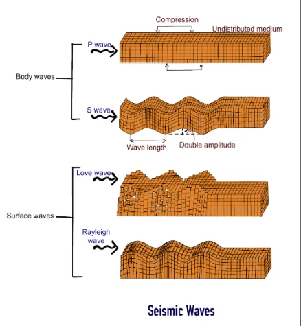
Seismic waves are energy shockwaves released during earthquakes from the focus. They travel at different speeds through different materials, recorded by a seismometer as a seismogram. Seismic waves are of two main types: Body waves (inside Earth) and Surface waves (on Earth’s surface). The difference in their propagation speed and medium proves the layered structure of the Earth.
Overview
Seismic waves originate at the earthquake focus (hypocenter). They travel differently depending on the density, temperature, and physical state of the medium (solid, liquid, gas). Waves are recorded using a seismometer, which produces a trace called a seismogram — this record tells us how fast waves travel, how the ground moved, and what layers they passed through.
For UPSC beginners: Seismology is the primary indirect method for knowing Earth’s internal structure since we cannot physically drill deep (maximum drilling ≈ 12 km vs. Earth’s radius 6,371 km).
Types of Seismic Waves
1. Body Waves:
These waves travel through the interior of the Earth. Their speed and direction change with the density/elasticity of layers — this helps scientists map boundaries between crust, mantle, and core.
a) Primary Waves (P-waves):
- Longitudinal, compressional waves (push–pull movement).
- Travel the fastest; hence they are the first to reach seismological stations.
- Medium: Can move through solids, liquids, and gases (all states).
- UPSC Tip: P-wave velocity suddenly drops at the Mantle–Outer Core boundary (Gutenberg discontinuity), proving the Outer Core is less rigid.
b) Secondary Waves (S-waves):
- Transverse/shear waves (motion perpendicular to propagation).
- Slower than P-waves.
- Medium: Travel only through solids — cannot travel through liquids or gases.
- UPSC Gold Point: The absence of S-waves in large regions (S-wave Shadow Zone: 103°–142°) proves the Outer Core is liquid.
2. Surface Waves:
Generated when body waves interact with Earth’s surface. They travel along the crust and cause maximum destruction during earthquakes because of their large amplitude.
a) Love Waves: Horizontal shearing motion; extremely damaging to buildings because foundations cannot withstand sideward movement.
b) Rayleigh Waves: Elliptical, rolling motion similar to ocean waves; these cause buildings and the ground to sway.
🔬 UPSC Analysis: Seismic Evidence
The study of wave velocities, refraction, reflection, and Shadow Zones is the most reliable method of understanding the Earth's interior.
- P-wave Shadow Zone (103°–142°): Caused by refraction through liquid outer core.
- S-wave Shadow Zone (also 103°–142°): Exists because S-waves cannot pass through liquid outer core.
- Moho Discontinuity: Sharp increase in P-wave velocity between Crust and Mantle.
- Gutenberg Discontinuity: Drop in P-wave velocity where Mantle meets liquid Outer Core.
- Lehmann Discontinuity: Increase in P-wave speed marking the transition from liquid Outer Core to solid Inner Core.
These findings prove the Earth is a layered body with varying density and composition — fundamental for UPSC Prelims & Mains answers on 'Earth’s interior' and 'seismic evidence'.
| Type | Characteristics |
|---|---|
| P-waves (Primary) | Fastest, compressional, travel through solids, liquids, gases, used for deep interior study |
| S-waves (Secondary) | Slower, transverse, only through solids, used to prove liquid outer core |
| Love Waves | Surface, horizontal side-to-side, highly destructive to foundations |
| Rayleigh Waves | Surface, rolling elliptical motion, causes swaying of structures |
Prelims tips
- P-waves are fastest and first to reach seismograph. They are used for earthquake early warning.
- S-waves cannot pass through liquid $\implies$ evidence of the liquid outer core.
- Surface waves (Love and Rayleigh) are the most destructive despite being the slowest.
- The S-wave shadow zone is large ($103^{\circ}$ to $180^{\circ}$); the P-wave shadow zone is smaller ($103^{\circ}$ to $142^{\circ}$).
- P-wave refraction at the core-mantle boundary proves the transition to the solid inner core.
Mains points
- Seismology's Role: P and S waves are the only reliable indirect sources that reveal the internal mechanical properties, density, and state of matter (solid/liquid) of the Earth's deep interior layers.
- Internal Structure: The existence of the liquid outer core is a foundational discovery derived directly from the S-wave shadow zone, while P-wave refraction indicates the solid inner core.
- Damage Correlation: Although body waves carry immense energy, surface waves are the primary cause of structural collapse and damage, linking seismological theory directly to civil engineering and disaster management.
- Geodynamic System: Seismology connects earthquake analysis with Plate Tectonics and Mantle Convection, as P and S wave velocity changes reflect the ductile (Asthenosphere) and rigid (Lithosphere) mechanical layers.
Seismic Waves
Seismic waves are energy shockwaves released during earthquakes from the focus. They travel at different speeds through different materials, recorded by a seismometer as a seismogram. Seismic waves are of two main types: Body waves (inside Earth) and Surface waves (on Earth’s surface). The difference in their propagation speed and medium proves the layered structure of the Earth.
Overview
Seismic waves originate at the earthquake focus (hypocenter). Their speed depends on the medium’s density, elasticity, and state (solid, liquid, gas). These waves are recorded by a seismometer, and the graph obtained is called a seismogram. It helps in identifying wave arrival times, ground motion patterns, and internal layering of the Earth.
UPSC Relevance: Since humans can drill only ~12 km while Earth’s radius is 6371 km, seismic waves are the main indirect method for studying Earth’s interior.
Types of Seismic Waves
1. Body Waves:
Travel through Earth’s internal layers. Their change in velocity, bending (refraction), and bouncing (reflection) reveal important layer boundaries and material states.
a) Primary Waves (P-waves):
- Longitudinal/compressional waves (push–pull motion parallel to propagation).
- Travel fastest (5–14 km/sec); first to reach seismograph stations → used in Earthquake Early Warning Systems (EEWS).
- Medium: Pass through solids, liquids, and gases.
- UPSC Insight: Sharp increase in P-wave velocity at the Crust–Mantle boundary helps detect the Moho Discontinuity.
b) Secondary Waves (S-waves):
- Transverse/shear waves (motion perpendicular to propagation).
- Slower than P-waves; arrive second.
- Medium: Travel only through solids.
- Proof of Liquid Outer Core: S-waves disappear beyond 103° from the focus → forming the S-wave shadow zone → confirms Outer Core is liquid.
2. Surface Waves:
Generated when P and S waves interact with or reach the Earth’s surface. They have the highest amplitude → cause maximum damage during earthquakes. They travel slower but are the most destructive for buildings.
a) Love Waves: Horizontal, side-to-side motion; extremely dangerous for foundations and bridges.
b) Rayleigh Waves: Move in a rolling, elliptical motion (like ocean waves); cause swaying and rocking of tall structures.
🔬 UPSC Analysis: Seismic Evidence
The study of P-wave & S-wave arrival times, bending/refraction patterns, and Shadow Zones is the most powerful tool for understanding Earth's interior.
- P-wave Shadow Zone (103°–142°): Caused by refraction through the liquid outer core.
- S-wave Shadow Zone (103°–142°): Because S-waves cannot pass through liquid outer core.
- Moho Discontinuity: Sudden increase in P-wave velocity → boundary between Crust & Mantle.
- Gutenberg Discontinuity: Sudden drop in P-wave velocity → Mantle–Outer Core boundary.
- Lehmann Discontinuity: Increase in P-wave velocity → Outer Core (liquid) to Inner Core (solid).
UPSC Scoring Tip: Shadow zones, wave behavior, and discontinuities form highly repeated questions in both Prelims (conceptual) and Mains (diagram + explanation).
| Type | Speed | Medium | Particle Motion | Destructive Power |
|---|---|---|---|---|
| P-Waves | Fastest | Solids, liquids, gases | Parallel (push-pull) | Low damage (Early Warning) |
| S-Waves | Slower | Only solids | Perpendicular (up-down) | Moderate damage (Proves Liquid Core) |
| Surface Waves | Slowest | Surface only | Oblique (side-to-side / rolling) | Highest damage |
Prelims tips
- P-waves are fastest and first to reach seismograph. They are used for earthquake early warning.
- S-waves cannot pass through liquid $\implies$ evidence of the liquid outer core.
- Surface waves (Love and Rayleigh) are the most destructive despite being the slowest.
- The S-wave shadow zone is large ($103^{\circ}$ to $180^{\circ}$); the P-wave shadow zone is smaller ($103^{\circ}$ to $142^{\circ}$).
- P-wave refraction at the core-mantle boundary proves the transition to the solid inner core.
Mains points
- Seismology's Role: P and S waves are the only reliable indirect sources that reveal the internal mechanical properties, density, and state of matter (solid/liquid) of the Earth's deep interior layers.
- Internal Structure: The existence of the liquid outer core is a foundational discovery derived directly from the S-wave shadow zone, while P-wave refraction indicates the solid inner core.
- Damage Correlation: Although body waves carry immense energy, surface waves are the primary cause of structural collapse and damage, linking seismological theory directly to civil engineering and disaster management.
- Geodynamic System: Seismology connects earthquake analysis with Plate Tectonics and Mantle Convection, as P and S wave velocity changes reflect the ductile (Asthenosphere) and rigid (Lithosphere) mechanical layers.
Types of Surface Waves – Love and Rayleigh Waves
Surface waves are the slowest but most destructive seismic waves, traveling along Earth’s surface. They include Love waves, which cause side-to-side ground motion, and Rayleigh waves, which cause elliptical rolling motion like ocean waves.
Love Waves
Named after A.E.H. Love, a British mathematician, who predicted their existence in 1911 using mathematical modelling of elastic surfaces.
They are the fastest type of surface wave and therefore arrive before Rayleigh waves, even though body waves (P & S) arrive earlier.
Move the ground in pure horizontal, side-to-side shearing motion, similar to dragging the ground left and right.
Love waves have no vertical displacement, making them extremely damaging to long rigid structures.
Like S-waves, they do not travel through fluids because shear motion cannot propagate in liquid or gaseous mediums.
Produce intense horizontal shear forces, severely damaging: foundations, bridges, pipelines, old masonry walls, and brittle buildings.
Cause heavy damage to roads, railway tracks, retaining walls, and poorly anchored columns due to horizontal displacement.
They are amplified in soft soils and reclaimed land, leading to stronger shaking in valley regions.
Love waves usually travel in the upper layers of the crust (low-velocity layers), making them dominant in shallow earthquakes.
Engineering Note: Multi-story buildings with poor lateral reinforcement are highly vulnerable to Love-wave shaking.
UPSC Tips: Love waves = fast, horizontal, destructive → common MCQ pattern.
Rayleigh Waves
Named after Lord Rayleigh (John William Strutt), who mathematically explained their behavior in 1885.
Travel with a motion similar to sea waves rolling across water — causing the ground to rise, fall, and move backward-forward in a loop.
Particle movement is elliptical (retrograde): upward/downward + forward/backward displacement.
Rayleigh waves penetrate deeper than Love waves (up to one wavelength depth), affecting both shallow and moderate-depth structures.
They cause buildings to sway violently, especially tall buildings or structures with soft lower floors.
Responsible for ground ripples sometimes visible during major earthquakes.
Due to combined vertical + horizontal motion, they trigger secondary disasters like: soil liquefaction, landslides, slope failure, ground cracking.
Travel slower than Love waves but often cause the maximum overall destruction due to larger amplitude.
Rayleigh waves decay slowly with distance, so they can be felt many kilometers away.
Engineering Note: Structures with poor base isolation, bridges, dams, and waterfront construction are most affected.
UPSC Tips: If the question asks which waves mimic ocean motion, cause rolling, or generate both vertical & horizontal displacement → Rayleigh Waves.
| Type | Discovered/Predicted by | Motion | Key Features | Destructive Power |
|---|---|---|---|---|
| Love Waves | A.E.H. Love (1911) | Horizontal (side-to-side) | Fastest surface wave; causes lateral shearing. | High (Foundation damage) |
| Rayleigh Waves | Lord Rayleigh (1885) | Elliptical (rolling) | Slowest wave overall; causes vertical and horizontal displacement. | Highest (Structural collapse) |
Prelims tips
- Love waves are the fastest surface waves, predicted by A.E.H. Love in 1911.
- Rayleigh waves were discovered by Lord Rayleigh in 1885.
- Love waves move ground side-to-side (horizontal shearing); Rayleigh waves cause elliptical rolling motion (vertical displacement).
- Surface waves cause the most destruction during earthquakes.
Mains points
- Love and Rayleigh waves represent two distinct destructive mechanisms of surface shaking (lateral shear vs. vertical roll), crucial for civil engineering and building resilience assessment.
- Love waves generate high frequency horizontal stress, specializing in damaging rigid foundations and walls.
- Rayleigh waves, due to their combined vertical and horizontal motion, are responsible for most instances of structural collapse and ground failure (like soil liquefaction).
- Surface waves' slow speed provides a measurable delay between the arrival of P/S waves and the onset of major shaking, critical for earthquake early warning systems.
Emergence of Shadow Zone
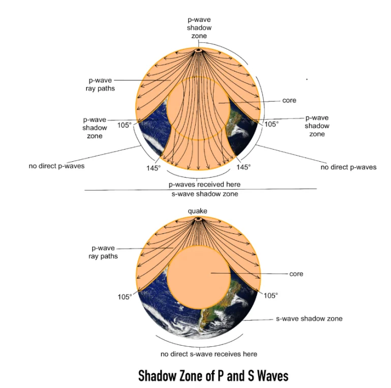
The shadow zone is the region on Earth’s surface where seismic waves from an earthquake are not recorded. Careful seismograph observations show that S-waves completely disappear beyond 105°, and P-waves are absent between 105°–145°. These observations proved that Earth’s outer core is liquid, while the inner core is solid.
Concept of Shadow Zone
Earthquake waves are not recorded in certain parts of the globe. These regions are called shadow zones. They form because seismic waves undergo refraction (bending), reflection, change in velocity, or complete disappearance when they pass through layers of Earth with contrasting density and physical properties.
Shadow zones are the strongest evidence that the Earth’s interior is not uniform — wave paths curve as they travel through denser or less dense materials.
The concept is essential because direct drilling is possible only up to 12 km, but seismic waves cover the entire Earth.
Key Observations from Seismographs
Seismographs within 0°–105° from the epicenter record both P and S waves.
Between 105° and 145°, neither P-waves nor S-waves are recorded ⇒ This region is the P-wave restricted shadow zone.
Beyond 105°, S-waves disappear completely until 180° ⇒ This forms the complete S-wave shadow zone.
The S-wave shadow zone spans nearly 40% of Earth's surface — one of the strongest proofs that S-waves cannot pass through liquids.
P-waves, however, only have a limited shadow zone (105°–145°), proving that they bend rather than disappear.
Seismographs beyond 145° show reappearance of P-waves, but with increased speed and different direction.
Scientific Explanation (Proof of Core State)
S-waves (Shear Waves): S-waves cannot travel through liquid. Their absence beyond 105° gives conclusive scientific proof that the outer core is liquid.
P-waves (Compressional Waves): P-waves can travel through liquids, but their speed decreases in the outer core causing strong refraction at the mantle–outer core boundary. This bending creates the central P-wave shadow zone (105°–145°).
After passing through the liquid outer core, P-waves enter the solid inner core, where their speed increases again due to higher density and rigidity. This causes them to reappear beyond 145°.
Inner Core Proof: The sudden increase in P-wave velocity inside the inner core is one of the strongest evidences that the inner core is solid (Fe–Ni alloy).
Significance of Observations
Established that Earth's interior is layered, consisting of materials with different densities and viscosities — not uniform.
Provided conclusive proof of a liquid outer core and a solid inner core — a major breakthrough in Earth Science.
Helped define important internal boundaries:
- Gutenberg Discontinuity: Mantle–Outer Core boundary (where S-waves vanish and P-waves slow down).
- Lehmann Discontinuity: Outer Core–Inner Core boundary (where P-wave speed increases again).
Explained the origin of Earth's magnetic field through the Geodynamo Theory, where the liquid outer core's convection currents generate the magnetic field.
Brought major advancements in seismology, global earthquake monitoring, travel-time curves, structural geology, and plate tectonics.
In UPSC terms: Shadow zones provide the clearest proof of Earth's internal structure — a recurring question in Prelims and Mains.
| Wave Type | Shadow Zone Range | Cause | Structural Inference |
|---|---|---|---|
| P-Waves | 105° – 145° | Strong refraction (bending) in liquid outer core | Inner core is solid |
| S-Waves | Beyond 105° (entire zone) | Cannot travel through liquid outer core | Outer core is liquid |
| Discontinuity | Boundary | Depth (Approx.) |
|---|---|---|
| Mohorovičić (Moho) | Crust and Mantle | ~35 km (Continental) / ~5 km (Oceanic) |
| Gutenberg | Mantle and Outer Core | ~2900 km |
| Lehmann | Outer Core and Inner Core | ~5100 km |
Prelims tips
- Shadow zone concept discovered by seismologists in early 20th century.
- P-wave shadow zone: 105°–145°.
- S-waves do not appear beyond 105° (entire zone).
- Outer core is liquid (S-wave absence, P-wave slowing).
- Inner core is solid (P-wave reappearance beyond 145° and increasing velocity).
- Shadow zones are critical evidence for Earth's layered structure.
Mains points
- Seismology's Dominance: The existence and precise geometry of the Shadow Zones are the fundamental scientific basis for understanding Earth's internal mechanical structure, providing the most reliable evidence about the density, state of matter, and thickness of deep layers.
- Proof of Differentiation: The S-wave shadow zone confirms the liquid state of the outer core—a vital feature that supports the Geodynamo theory for Earth's protective magnetic field, linking the core's state directly to the viability of life on the surface.
- Internal Dynamics: P-wave and S-wave velocity changes across discontinuities (Moho, Gutenberg, Lehmann) map the boundaries between the rigid (Lithosphere), ductile (Asthenosphere), and liquid/solid Core layers, which are essential for modeling Mantle Convection and Plate Tectonics.
Comparison of Primary, Secondary and Surface Waves
Seismic waves differ in their speed, wavelength, direction, arrival time, and the medium they can travel through. P-waves are the fastest and first to arrive, S-waves follow with slower speed and shear motion, while surface waves are the slowest but most destructive.
Primary Waves (P-Waves)
First to reach Earth’s surface, making them crucial for identifying the exact origin time of an earthquake.
Very short wavelength, enabling them to penetrate the deeper and denser layers of the Earth.
Compressional waves: particles move in a push-pull motion (back-and-forth), parallel to the direction of propagation.
Can travel through solids, liquids, and gases because compressional forces can pass through all states of matter.
Fastest seismic waves (5–14 km/sec). Their speed difference across layers helps in identifying Earth’s internal boundaries.
Used in Earthquake Early Warning Systems (EEWS) since they arrive seconds before destructive S and Surface waves.
Cause temporary changes in volume and density of the material (compression and rarefaction zones).
Velocity increases in rigid materials and decreases in molten or less rigid zones → key to mapping crust–mantle variations.
P-waves refract strongly at the Mantle–Outer Core boundary, creating the P-wave shadow zone.
Secondary Waves (S-Waves)
Arrive after P-waves, with a distinct time lag that helps estimate the distance of the earthquake from the seismograph.
Medium wavelength and moderate energy transfer.
Shear or transverse motion: particles move perpendicular to the direction of wave travel (up–down movement).
Travel only through solids because shear forces cannot propagate through liquids or gases.
This property gives conclusive evidence that the Outer Core is liquid (since S-waves disappear beyond 105°).
Slower than P-waves: speed ranges from 3.5–7.2 km/sec depending on density and elasticity of the material.
Cause stronger shaking than P-waves due to larger amplitude and shear motion.
S-waves travel only through the body of the Earth, not the surface.
Their complete absence in certain angular regions forms the S-wave Shadow Zone, covering about 40% of Earth’s surface.
Surface Waves
Last to reach Earth’s surface and thus considered the slowest seismic waves (3–5 km/sec).
Longest wavelength and highest amplitude among all seismic waves.
Amplitude is greatest at the surface and decreases with depth, making them highly destructive in populated areas.
Oblique motion combining both vertical and horizontal movement:
- Love Waves: Horizontal shearing (side-to-side).
- Rayleigh Waves: Rolling elliptical motion, similar to ocean waves.
Travel only along Earth’s surface (solid medium) and are not transmitted deep into the Earth's interior.
Most destructive waves due to high amplitude, long duration, and combined motions.
Responsible for severe damage: ground fissures, building collapse, foundation cracking, and soil liquefaction.
Their energy decays slowly with distance, causing shaking to be felt far from the epicenter.
Surface waves dominate in shallow-focus earthquakes, which account for over 80% of global quakes.
| Criteria | Primary Waves (P) | Secondary Waves (S) | Surface Waves |
|---|---|---|---|
| Time to reach surface | First to arrive | After P-waves | Last to arrive |
| Wavelength | Very short | Medium | Longest |
| Direction | Parallel (push-pull) | Perpendicular (shear) | Oblique (side-to-side/rolling) |
| Medium of travel | Solids, liquids, gases | Only solids | Surface (solid) only |
| Speed | Fastest (5–14 km/s) | Slower (3.5–7.2 km/s) | Slowest (3–5 km/s) |
| Destruction | Least destructive | Moderate destruction | Most destructive |
Prelims tips
- P-waves are compressional and fastest, travel through all media. Used for Earthquake Early Warning Systems (EEWS).
- S-waves are shear waves, cannot travel through liquid $\implies$ Outer Core is liquid.
- Surface waves (Love and Rayleigh) cause the maximum destruction due to long wavelength and large amplitude.
- The time difference between P and S waves (P-S time) is used to calculate the distance to the epicenter.
Mains points
- Internal Structure: The comparative behavior of P and S waves across discontinuities (Moho, Gutenberg, Lehmann) is the basis for constructing the definitive model of Earth's layered internal structure, proving the liquid and solid states of the core.
- Hazard Assessment: While P-waves provide early warning, Surface Waves are the primary focus of civil engineering for earthquake-resistant design, as their motion types (horizontal shear vs. rolling) cause specific structural failures (foundation collapse, liquefaction).
- Energy and Wavelength: Surface waves' greater destructive power stems from their long wavelength, which allows them to carry more energy over a wider area of the surface compared to the focused, high-frequency energy of body waves.
Structure of the Earth – Crust and E-Prime Layer
The Earth’s structure begins with the crust, its outermost and thinnest layer, composed of the continental crust (Sial) and oceanic crust (Sima). A distinct new discovery is the E-Prime layer at the outermost part of the Earth’s core, formed by long-term interaction of surface water with deep layers.
Crust
The outermost and thinnest solid layer of the Earth. It forms the entire land surface and ocean floors. It is rigid, brittle, and broken into tectonic plates.
The boundary separating the crust from the mantle is the Mohorovičić Discontinuity (Moho). At the Moho, seismic waves suddenly speed up due to the change from granitic/basaltic crust to denser peridotite mantle.
Average thickness: ~5 km under oceans (oceanic crust), ~30–40 km under continents (continental crust). Under major mountains like Himalayas, thickness may reach 70 km.
Density difference: Continental crust (Sial) ≈ 2.7 g/cm³; Oceanic crust (Sima) ≈ 3.5 g/cm³.
Continental crust is older (up to 4 billion years), while oceanic crust is younger (usually <200 million years) due to continuous recycling via subduction.
Divisions of Crust
1. Upper Crust (Continental Crust):
- Granitic in nature (felsic), lighter and less dense.
- Forms continents and major mountain systems.
- Rich in silica (Si) and alumina (Al) → called 'Sial'.
- Contains older rocks like granite, gneiss, schist, quartzite.
- More buoyant and thicker due to lower density → explains why continents 'float' higher on the mantle (isostasy).
2. Lower Crust (Oceanic Crust):
- Basaltic in nature (mafic), darker and denser.
- Forms ocean floors and mid-ocean ridges.
- Rich in silica (Si) and magnesium (Ma) → called 'Sima'.
- Continually created at mid-ocean ridges and destroyed at subduction zones → key to plate tectonics.
- Younger, thinner, and heavier → explaining why oceans sit at lower elevation than continents.
E-Prime Layer (Core-Mantle Boundary)
A recently identified distinct layer located at the outermost region of Earth’s liquid outer core, right below the mantle (at the Core-Mantle Boundary, ~2900 km depth).
It is considered an important discovery because it challenges the older belief that the core and mantle are chemically isolated.
Formation:
Formed over billions of years due to surface water being dragged deep into Earth by subducting plates (plate tectonics).
This water reacts with iron-rich material of the outer core, forming a unique layer that is chemically different from both mantle and core.
This shows that water is not limited to crust and mantle — it participates in deep Earth chemical cycles.
Composition:
The E-Prime layer is Hydrogen-rich, silicon-poor, suggesting that water (H₂O) undergoes chemical dissociation at extreme pressures.
Contains iron-hydride compounds (Fe–H) formed by reaction between water components and molten iron.
Its unusual composition confirms that deep Earth is chemically dynamic, not static.
Significance (UPSC Focus):
1. Indicates a deep water cycle where water travels from the surface → mantle → core, proving that Earth is more interactive internally than previously believed.
2. Suggests mineral and chemical exchange between the mantle and core, revising earlier models that assumed almost no mixing at the boundary.
3. May influence the strength and behavior of Earth’s magnetic field, because the magnetic field originates in the fluid motions of the outer core (Geodynamo).
4. Could help explain variations in heat flow from the core to the mantle, influencing mantle plumes (hotspots like Hawaii, Iceland).
5. Provides insights into Earth's early history — how water arrived, survived, and circulated through deep layers.
6. Has major implications for understanding planetary evolution, as similar layers may exist in other Earth-like planets.
| Aspect | Sial (Continental Crust) | Sima (Oceanic Crust) |
|---|---|---|
| Composition | Silica + Alumina (Felsic) | Silica + Magnesium (Mafic) |
| Rock Type | Granitic | Basaltic |
| Density | 2.7 g/cm³ (lighter) | 3.5 g/cm³ (denser) |
| Location | Forms continents | Forms ocean floors |
| Thickness | ≈ 30 km (Thicker) | ≈ 5 km (Thinner) |
Prelims tips
- Continental crust (Sial) is lighter, thicker, and granitic. Oceanic crust (Sima) is denser, thinner, and basaltic.
- Moho discontinuity separates crust from mantle. It is shallower under oceans (~5 km) than under continents (~30 km).
- E-Prime layer: Hydrogen-rich, silicon-poor, formed at the Core-Mantle Boundary (Gutenberg Discontinuity).
- The density difference between Sial and Sima is key to Isostasy (the principle of buoyancy that explains continental elevation).
Mains points
- Crustal Differentiation: The clear distinction between Sial and Sima explains tectonic processes; the denser Sima is preferentially subducted under the lighter Sial, driving plate tectonics.
- E-Prime & Geodynamics: The discovery of the E-Prime layer necessitates revising models of the deep Earth water cycle and heat flow, suggesting a dynamic chemical exchange between the mantle and core, which could affect the magnetic field's stability.
- Long-term Interaction: The E-Prime layer demonstrates that seemingly isolated surface processes (like the ocean's water content) have a long-term chemical and thermal influence on the deep core boundary.
Structure of the Earth – Mantle and Core (Detailed)
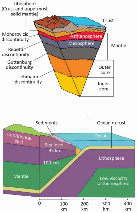
The mantle is the thickest layer of Earth, extending from the Moho discontinuity to 2,900 km. It is composed of silicate minerals and divided into upper and lower mantle, including special zones like asthenosphere and lithosphere. Below lies the metallic core (Nife), divided into a liquid outer core and solid inner core. The innermost inner core exhibits anisotropy, offering clues about Earth's deep processes and magnetic field generation.
Mantle
The mantle is the largest and thickest layer of Earth, accounting for ~84% of Earth’s volume and ~67% of its mass.
Extent: From ~35 km (Moho Discontinuity) to ~2,900 km depth (Gutenberg Discontinuity).
Composition: Dominated by silicate minerals such as olivine, pyroxene, garnet, peridotite. Elements include oxygen, magnesium, silicon, and iron.
Seismic Behavior: P-waves speed up in the mantle due to higher density and rigidity compared to crust; S-waves travel efficiently because mantle is solid.
Temperature: From ~500°C near Moho to 4,000°C near the core–mantle boundary.
Density increases with depth (3.3 g/cm³ in upper mantle to >5 g/cm³ near CMB).
Mantle convection drives plate tectonics, volcanic hotspots (Hawaii, Iceland), and continental drift.
Asthenosphere (The Ductile Zone)
A weak, ductile, plastic layer within the upper mantle, located beneath the lithosphere. Extends ~100–400/500 km deep.
Temperature is close to the rock’s melting point → makes it partially molten (1–10% melt).
Acts as the "lubricating layer" allowing rigid lithospheric plates to move, enabling tectonic activity.
Primary source of basaltic magma during volcanic eruptions.
Low-velocity zone: Seismic waves slow down here — an important UPSC fact.
Lithosphere (The Rigid Zone)
Comprises the crust + uppermost solid mantle.
Rigid, brittle, broken into tectonic plates (7 major, 8 minor). Thickness varies:
- Oceanic lithosphere: 5–100 km
- Continental lithosphere: 30–200 km
Responsible for earthquakes, volcanoes, subduction zones, rift valleys, and mountain-building (orogeny).
Lithospheric plates move over the ductile asthenosphere due to convection currents.
Core
Extent: From ~2,900 km depth to 6,371 km (Earth’s center). The core contributes ~32% of Earth's mass.
Composition: Mostly iron (Fe) and nickel (Ni) → called 'Nife'.
Extremely dense: ~11–13 g/cm³, increasing with depth due to pressure.
Core is responsible for Earth's magnetic field + geothermal heat.
Outer Core (The Liquid Dynamo)
State: Liquid iron–nickel alloy (Thickness ~2,200 km).
Temperature: 4,500–5,500°C; pressure insufficient to solidify iron here.
The convection of molten metallic iron creates electrical currents → generating Earth's magnetic field via the Geodynamo effect.
The S-wave shadow zone (105°–180°) is definitive proof of its liquid state.
Outer core also produces P-wave shadow zone (105°–145°) due to strong refraction.
Influences length of day (LOD) and participates in magnetic reversals.
Inner Core (The Solid Regulator)
State: Solid (radius ~1,271 km). Temperature ~5,200°C, similar to the Sun’s surface.
It remains solid due to extreme pressure, which increases the melting point of iron.
Seismic evidence shows anisotropy — P-waves travel faster north–south than east–west, suggesting aligned iron crystals.
Inner core grows slowly (~1 mm/year) as Earth cools — releasing heat that powers the dynamo.
Acts as a stabilizing factor for long-term magnetic field behaviour.
Innermost Inner Core
A newly identified, distinct central region of the inner core (approx. 600 km diameter).
Shows unique anisotropy, likely due to a different arrangement of iron crystals or separate growth history.
Gives clues about Earth’s long-term cooling, early core formation, and magnetic field reversals.
Represents the deepest known physical structure on Earth.
| Layer | Depth (km) | State | Special Features |
|---|---|---|---|
| Asthenosphere | Upper Mantle (to 500) | Ductile/Semi-molten | Source of magma, allows plate movement |
| Lithosphere | Crust + Upper Mantle (to 200) | Rigid/Solid | Forms tectonic plates; responsible for earthquakes |
| Outer Core | 2891–5100 | Liquid | Generates magnetic field (Geodynamo); S-wave shadow zone |
| Inner Core | 5100–6371 | Solid | Anisotropy (wave velocity varies by direction); extreme pressure |
Prelims tips
- Mantle forms ~84% of Earth's volume. Its composition is rich in silicates (Olivine, Peridotite).
- Asthenosphere is the ductile layer enabling plate movement, located within the Upper Mantle.
- Outer core is liquid (proven by S-wave shadow zone) and is the source of Earth’s magnetic field (Geodynamo).
- Inner core is solid due to pressure; it, along with the innermost core, exhibits anisotropy.
- Moho discontinuity (Crust/Mantle) and Gutenberg discontinuity (Mantle/Outer Core) are key boundaries.
Mains points
- Tectonic Engine: Mantle convection in the plastic/viscous mantle (Asthenosphere) drives Plate Tectonics and shapes the Lithosphere, explaining global earthquake and volcano distribution.
- Geodynamo: The Outer Core's liquid state and metallic composition are essential for generating the Geodynamo (magnetic field), which protects the biosphere from solar radiation.
- Phase Transitions: The core layers demonstrate crucial phase transitions—the Outer Core is liquid due to temperature, while the Inner Core is solid due to extreme pressure overriding temperature effects.
- Seismic Anisotropy: The Inner Core's anisotropy provides valuable seismic data suggesting the alignment of iron crystals, offering clues about the core's formation, dynamics, and heat exchange with the Mantle.
Seismic Discontinuities of the Earth
Seismic discontinuities are boundaries inside the Earth where there is a sudden change in seismic wave velocity due to differences in density and composition of materials. These boundaries help in understanding Earth’s internal layering.
Conrad Discontinuity
Transition: Between upper continental crust (SIAL – silica + alumina) and lower oceanic crust (SIMA – silica + magnesium).
Depth: Found within the continental crust (15–20 km under continents), but not a globally consistent boundary and usually absent beneath oceans.
Nature: Represents a change from light-colored, granitic rocks to darker, denser basaltic rocks.
Seismic Behavior: Minor increase in P-wave velocity due to higher density and mafic mineral content.
Significance: Helps differentiate the two chemical layers of the crust; useful in understanding continental evolution and crustal thickening during orogeny.
Mohorovičić Discontinuity (Moho)
Transition: Between the Crust and the Mantle (the base of the crust).
Depth: ~35–40 km under continents; shallower under oceans (~5–10 km).
Discovery: Identified by Andrija Mohorovičić (1909) after observing sudden jump in seismic wave speeds.
Seismic Wave Change: Sharp increase in velocity of P and S waves, due to shift from basalt/granite to dense peridotite.
Significance: Fundamental boundary indicating a major change in mineralogy and density. Used extensively in plate tectonics, mountain building studies, and seismic modeling.
Repetti Discontinuity
Transition: Between upper mantle and lower mantle.
Depth: ~700–800 km (corresponds to major mineral transformations like olivine → spinel → perovskite).
Nature: Marks change from relatively flexible upper mantle rocks to more rigid lower mantle rocks.
Seismic Behavior: Increase in wave velocities due to higher-density mineral phases.
Significance: Divides mantle into two layers with different flow properties; major factor in mantle convection and plate dynamics.
Gutenberg Discontinuity
Transition: Between Mantle and Core.
Depth: ~2,900 km (core–mantle boundary).
Seismic Wave Change: S-waves disappear entirely; P-waves slow down sharply and get strongly refracted.
Reason: The outer core is liquid; hence shear waves cannot propagate through it.
Significance: First seismic evidence that Earth’s outer core is liquid; plays a major role in convection, heat transfer, plume formation, and the geodynamo (magnetic field generation).
Lehmann Discontinuity
Transition: Between outer core (liquid) and inner core (solid).
Depth: ~5,100 km.
Seismic Wave Change: P-waves speed up again, indicating a shift from liquid to a more rigid, solid state.
Discovery: Identified by Inge Lehmann in 1936 using deep-focus earthquake data.
Nature: Inner core solidifies due to immense pressure increasing iron’s melting point.
Significance: Conclusively proved the inner core is solid, revealed anisotropy in core structure, and enhanced understanding of Earth's thermal evolution and magnetic field reversals.
| Name | Transition Between | Depth (Approx.) | Significance |
|---|---|---|---|
| Conrad Discontinuity | Sial and Sima (within crust) | Varies (continental crust) | Distinguishes granitic and basaltic composition |
| Mohorovičić (Moho) | Crust and Mantle | 5–10 km (oceanic), 35 km (continental) | Base of crust; sharp velocity increase |
| Repetti Discontinuity | Upper and Lower Mantle | 700–800 km | Divides mantle into two zones (phase transition) |
| Gutenberg Discontinuity | Mantle and Core | 2,900 km | Outer core is liquid (S-wave disappears) |
| Lehmann Discontinuity | Outer and Inner Core | 5,100 km | Inner core is solid (P-wave speed increases) |
Prelims tips
- Moho discontinuity separates crust and mantle (~35 km under continents). It is shallower under oceans.
- Gutenberg discontinuity (2,900 km): marks the liquid outer core (S-waves disappear).
- Lehmann discontinuity (5,100 km): marks the solid inner core.
- Conrad and Repetti discontinuities are found within the major layers.
- Inge Lehmann, a Danish seismologist, discovered the boundary between the outer and inner core.
Mains points
- Discontinuities confirm the theory of differentiation, proving Earth is layered by density and composition.
- The Gutenberg Discontinuity is fundamental to the Geodynamo Theory, marking the boundary that drives heat transfer and molten iron convection to generate the magnetic field.
- The Moho Discontinuity is a critical reference point for studying tectonic processes; its depth difference under continents and oceans is a key element of Isostasy.
- The Repetti Discontinuity marks a major phase transition in the mantle, where minerals restructure due to pressure, affecting the overall viscosity and convection patterns.
Temperature, Pressure, Density of Earth’s Interior & Magnetic Field
Temperature, pressure, and density increase with depth inside the Earth, influencing its structure and dynamics. The Earth’s liquid outer core, through the geodynamo effect, generates the magnetic field that protects life and guides navigation.
Temperature in Earth’s Interior
Temperature increases with depth, but the rate of increase is non-uniform. The steepest rise occurs near the surface, especially in the upper crust.
Geothermal Gradient: Rate of temperature increase with depth. Average: 25–30°C per km in the upper crust, but decreases to ~0.5°C/km deeper in the mantle.
Geothermal gradient varies by region: high in volcanic/hydrothermal areas (Iceland, Japan), low in old stable cratons.
Sources of Heat:
- Radioactive decay of isotopes: Uranium-238, Thorium-232, Potassium-40 — main source of heat in the mantle and crust.
- Residual (primordial) heat from Earth's formation (accretion + differentiation).
- Heat from core crystallization: When the inner core solidifies, it releases latent heat.
- Tidal heating (minor effect) due to gravitational pull of Moon and Sun.
Mantle–core boundary (CMB): ~4000°C. Here, silicates begin to partially melt.
Earth’s center: ~5500–6000°C, comparable to the surface of the Sun.
High temperatures drive mantle convection, which powers plate tectonics.
Pressure in Earth’s Interior
Pressure increases steadily with depth due to the weight of overlying rocks (lithostatic pressure).
Pressure rise is continuous: from 1 atmosphere at the surface to ~364 GPa (3.6 million atmospheres) at the center.
Pressure gradient: ~30 MPa per km in the crust, increasing downward.
Significance:
- High pressure keeps the inner core solid, even though temperatures exceed iron’s melting point under surface conditions.
- Controls phase changes in mantle minerals (e.g., olivine → spinel → perovskite).
- Affects seismic wave velocities — higher pressure generally increases wave speed.
Density in Earth’s Interior
Density increases with depth due to compaction, pressure, and concentration of heavy elements toward the center (differentiation).
Crust: ~2.7–3.0 g/cm³ — dominated by light silicates (granite, basalt).
Mantle: ~3.3–5.7 g/cm³ — composed of dense silicates (peridotite, garnet).
Core: ~9.5–14.5 g/cm³ — rich in iron & nickel (Nife).
This progressive increase in density explains why seismic waves speed up in the mantle but slow down in the liquid outer core.
Average density of Earth (~5.5 g/cm³) is much higher than crustal rocks — proving the existence of a massive metallic core.
Earth’s Magnetic Field
Source: The liquid outer core composed of molten iron and nickel.
Geodynamo Theory:
- High temperatures create convection currents in molten iron.
- Earth’s rotation causes Coriolis force, organizing these currents into helical spirals.
- Moving electrically conductive fluid generates electric currents, which produce a magnetic field.
- This magnetic field is self-sustaining due to feedback (dynamo action).
Magnetic Poles:
- Magnetic north is not the same as geographic north — it wanders over time.
- Polarity reversals occur every few hundred thousand years (recorded in ocean floor basalts).
- Paleomagnetism supports seafloor spreading and plate tectonics.
Declination Angle: The angular difference between geographic north (true north) and magnetic north.
Importance:
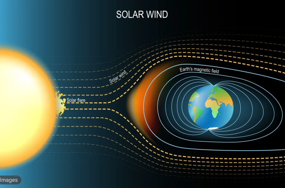
- Magnetic field deflects solar wind and cosmic radiation, creating the magnetosphere.
- Prevents atmospheric erosion — key reason Earth retained its atmosphere and life could exist.
- Essential for navigation (compass).
| Depth | Temperature | Pressure | Density |
|---|---|---|---|
| Surface | 15°C (average) | 1 atm | ~2.7 g/cm³ (crustal rocks) |
| 100 km | 1200°C | 3 GPa | 3.0 g/cm³ |
| 700 km (Repetti) | ~2000°C | 23 GPa | 3.5–4 g/cm³ |
| 2900 km (Gutenberg) | 4000°C | 135 GPa | 5.5 g/cm³ |
| 5100 km (Lehmann) | 5000–5200°C | 330 GPa | 10–12 g/cm³ |
| 6371 km (Center) | 5500–6000°C | 364 GPa | 13–14 g/cm³ |
Prelims tips
- Geothermal gradient: ~25–30°C/km in upper crust, but decreases with depth.
- Outer core (liquid) generates Earth’s magnetic field (geodynamo).
- Inner core is solid due to pressure.
- Earth's average density (5.5 g/cm³) confirms the presence of a metallic core.
- Magnetic poles shift (polar wander) and reverse (magnetic reversals, studied via paleomagnetism).
Mains points
- Pressure vs. Temperature: The interplay between rapidly increasing pressure and temperature determines the physical state of layers (e.g., solid mantle, liquid outer core, solid inner core).
- Heat Engine: Decay of radioactive isotopes and primordial heat provide the energy for Mantle Convection (driving plate tectonics) and Outer Core Convection (driving the geodynamo).
- Geomagnetic Shield: The magnetic field is critical for planetary habitability, protecting Earth's atmosphere and life from solar wind and cosmic radiation.
- Density Stratification: The continuous increase in density from the crust to the core is evidence of Differentiation—the separation of heavy (Fe, Ni) and light (Si, Al) materials during Earth's formation.
Earth’s Magnetic Phenomena: Polar Reversal, Magnetosphere, Radiation Belts, and Anomalies
Earth’s magnetic field is dynamic, shaped by core convection and solar wind interactions. Phenomena like polar reversal, magnetosphere shielding, Van Allen belts, geomagnetic storms, and anomalies like the South Atlantic Anomaly highlight the importance of geomagnetism in sustaining life and protecting technologies.
Polar Reversal
Over thousands to millions of years, Earth’s magnetic poles can completely reverse (north becomes south and vice-versa).
Cause: Non-linear changes in convection and flow patterns in the liquid outer core which alter the geodynamo.
Evidence: Alternating polarity recorded in volcanic rocks and ocean-floor basalts (magnetic stripes).
Last major reversal: ~780,000 years ago (Brunhes–Matuyama reversal).
Behaviour: Reversals are irregular — intervals between reversals vary from tens of thousands to millions of years; transitional periods can last thousands of years.
Impacts & Notes: During a reversal the field strength can weaken (raising radiation exposure at top of atmosphere) but geological records show life persisted through many reversals.
Historical example & research relevance: Paleomagnetic records from seafloor spreading provide a time-marker used in plate reconstructions — a high-value fact for Mains.
Magnetosphere
Region above the ionosphere dominated by Earth’s magnetic field; shaped by interaction with the solar wind.
Function: Acts as the first line of defense against charged solar and cosmic particles by redirecting them around the planet.
Key dimensions: On the dayside the magnetopause typically lies at ~10 Earth radii (~64,000 km) from Earth but compresses during strong solar storms; the nightside magnetotail extends several hundred Earth radii.
Components:
1. Magnetopause: Dynamic boundary between magnetosphere and solar wind plasma (location varies with solar activity).
2. Magnetosheath: Turbulent, shocked solar wind region just outside the magnetopause.
3. Bow Shock: Sun-facing shock where solar wind slows and diverts around the magnetosphere.
4. Plasmasphere: Inner region of co-rotating low-energy plasma (a few Earth radii).
Practical note: Magnetospheric compression during CMEs can move radiation belts and increase satellite exposure.
Van Allen Radiation Belts
Discovered in 1958 by James Van Allen using early space probes.
Description: Doughnut-shaped zones of trapped energetic charged particles (protons & electrons) held by Earth's magnetic field.
Typical structure & altitudes: Inner belt (~1,000–6,000 km; proton-dominated), Outer belt (~13,000–60,000+ km; electron-dominated and highly variable).
Origins: Primarily accelerated solar wind particles and cosmic-ray albedo neutron decay (CRAND).
Function: Provide a shield by trapping high-energy particles but also present radiation hazards to satellites and astronauts.
Mitigation: Satellite designers use radiation-hardened components, operational safe-modes, and orbital avoidance strategies (e.g., minimize time in SAA).
Geomagnetic Storm
A transient disturbance of Earth's magnetosphere caused by enhanced solar wind pressure, high-speed streams, or Coronal Mass Ejections (CMEs).
Impacts:
- Disrupts radio communications, degrades GNSS/GPS accuracy, and affects HF/VHF propagation.
- Induces geomagnetically induced currents (GICs) that can damage transformers and power grids (historic blackouts recorded during major storms).
- Damages satellites (single-event upsets, charging), increases radiation risk to crewed missions, and affects pipeline corrosion.
- Produces spectacular auroras at high latitudes; during extreme events (e.g., Carrington-class) aurorae can be seen at much lower latitudes.
Indexing & monitoring: Kp and Dst indices quantify storm strength — commonly referenced in operational alerts.
South Atlantic Anomaly (SAA)
A persistent weak-field region centered over the South Atlantic, off the coast of Brazil, where the inner Van Allen belt comes unusually close to Earth's surface (~200–500 km range in some spots).
Effect: Increased flux of energetic particles leads to elevated radiation doses for LEO satellites and potential single-event upsets in electronics; some spacecraft enter protective modes when transiting the SAA.
Significance: The SAA represents a regional minimum in field strength and is important for satellite mission planning and risk assessment.
| Phenomenon | Description | Significance |
|---|---|---|
| Polar Reversal | Reversal of Earth’s magnetic poles over thousands to millions of years | Explains alternating polarity in rocks; linked to convection changes in core |
| Magnetosphere | Region dominated by Earth’s magnetic field that deflects solar wind | Shields Earth from charged solar particles and cosmic rays; critical for habitability |
| Van Allen Belts | Zones of trapped charged particles encircling Earth | Deflects harmful radiation but poses hazards for spacecraft and astronauts |
| Geomagnetic Storm | Transient disturbance caused by CMEs and high-speed solar wind streams | Disrupts satellites, GNSS/GPS, power grids and can produce auroras |
| South Atlantic Anomaly | Regional depression in magnetic field strength between Africa & South America | Increases radiation exposure for LEO satellites; important for mission planning |
Prelims tips
- Polar reversal last occurred ~780,000 years ago (Brunhes–Matuyama reversal).
- Magnetopause on the dayside averages ~10 Earth radii (~64,000 km) but moves during storms.
- Van Allen belts: inner belt ~1,000–6,000 km (protons), outer belt ~13,000–60,000+ km (electrons).
- Van Allen belts discovered in 1958 by James Van Allen.
- Geomagnetic storms are measured by indices like Kp and Dst and can disrupt power grids and satellites.
- South Atlantic Anomaly (SAA) is the weakest region of the magnetic field and causes higher-than-usual radiation exposure for LEO satellites.
Mains points
- Polar reversal indicates long-term variability and instability in geodynamo processes operating in the outer core; it is recorded as polarity stripes on the ocean floor and is useful in plate reconstructions.
- The magnetosphere is a crucial planetary shield that interacts with the solar wind; it underpins habitability by deflecting charged particles and maintaining the atmosphere.
- Van Allen belts serve as a protective barrier for low altitudes but present operational hazards for satellites; satellite design must account for belt dynamics and SAA passages.
- Geomagnetic storms expose modern technology to space weather hazards — power grids, communication and navigation systems, and satellites are vulnerable, underscoring the need for resilient infrastructure and forecasting.
- The South Atlantic Anomaly highlights that Earth's magnetic field is spatially non-uniform; such regional weaknesses necessitate targeted mitigation strategies for spacecraft.
- Overall, these phenomena demonstrate the deep coupling between Earth's interior dynamics (core convection) and external space environment (solar activity), a theme important for both physical geography and policy planning (space weather preparedness).
Rocks and Minerals – Minerals and Their Types
Minerals are the naturally occurring, inorganic 'building blocks' of rocks, each with a unique chemical composition and internal crystal structure. They are classified chemically into groups like Silicates (the most abundant, ~90% of the crust), Carbonates (form limestone), Oxides (source of iron/aluminum), and Sulphides (source of copper/lead).
Minerals: The Building Blocks
A mineral is a naturally occurring, inorganic substance with a definite chemical composition and an orderly internal atomic structure (crystal structure).
Mineral vs. Rock (Beginner Analogy): A mineral is an 'ingredient' (e.g., Quartz). A rock is the final 'cake' (e.g., Granite), which is a mixture of multiple minerals (Quartz + Feldspar + Mica).
Physical Properties (For Identification): Minerals are identified by properties like Hardness (Mohs Scale), Luster (metallic/non-metallic), Cleavage (breaking on flat planes), Fracture (irregular breaking), and Color.
Major Types of Minerals (Chemical Classification)
1. Silicate Minerals (The Rock-Formers)
Composition: Made of Silicon (Si) + Oxygen (O), forming the Silicon-Oxygen Tetrahedron (SiO₄), which is the fundamental building block. These tetrahedra link together in complex structures, often with metals like Mg, Fe, Al, K.
Abundance: The most dominant group, covering ~90% of Earth’s crust.
Examples: Quartz, Feldspar, Mica, Olivine, Pyroxene, Amphibole.
Importance: Form common rocks (Granite, Basalt), used in glass industry, ceramics.
2. Carbonate Minerals
Composition: Contain the carbonate ion (CO₃²⁻).
Formation: Mostly formed by biological and chemical processes in sedimentary environments (e.g., coral reefs, marine shells).
Examples: Calcite (forms Limestone), Dolomite.
Importance: Cement industry, building stones; responsible for Karst topography (caves, sinkholes) due to dissolution by acid rain.
3. Oxide Minerals
Composition: Metals combined with Oxygen (O).
Significance: Crucial economic source for many metallic ores.
Examples: Hematite & Magnetite (Iron ore), Bauxite (Aluminum ore), Corundum (Ruby/Sapphire).
4. Sulphide Minerals
Composition: Metals combined with Sulphur (S).
Significance: Major sources of metallic ores, often formed by hydrothermal (hot water) processes.
Examples: Pyrite (FeS₂), Galena (Lead ore), Chalcopyrite (Copper ore), Zinc Blende (Zinc ore).
| Type | Composition Base | Examples (Economic Use) |
|---|---|---|
| Silicate Minerals | Silicon + Oxygen (SiO₄) | Quartz (Glass), Feldspar (Ceramics), Mica |
| Carbonate Minerals | Carbonate ions (CO₃²⁻) | Calcite (Cement), Dolomite |
| Oxide Minerals | Metals + Oxygen | Hematite (Iron ore), Bauxite (Aluminum ore) |
| Sulphide Minerals | Metals + Sulphur | Galena (Lead ore), Chalcopyrite (Copper ore) |
Prelims tips
- Minerals are the building blocks of rocks.
- Silicates are the most abundant minerals (~90% of Earth’s crust), built by the Silicon-Oxygen Tetrahedron (SiO₄).
- Quartz and Feldspar are the most common rock-forming silicates.
- Calcite (a Carbonate) reacts with acid and forms Karst Topography.
- Hematite/Magnetite (Oxides) are key Iron ores.
- Bauxite (Oxide) is the primary Aluminum ore.
- Galena (Sulphide) is the primary Lead ore.
Mains points
- Economic Geography: The classification of minerals (Oxides, Sulphides) is fundamental to understanding the global distribution of metallic resources (Iron, Aluminum, Copper), which forms the base of industrial economies.
- Geomorphology: Mineral properties directly influence weathering and landform development. For example, resistant minerals like Quartz form beaches, while soluble minerals like Calcite (in Limestone) weather chemically to form Karst landscapes.
- Rock Cycle: Minerals are not static; they are transformed through the rock cycle. Silicates melt to form igneous rocks, erode to form sedimentary rocks, and are altered by pressure to form metamorphic rocks.
- Plate Tectonics: Mineral formation is linked to plate boundaries. Sulphide deposits often form at mid-ocean ridges (hydrothermal vents), and new minerals are created under high pressure at subduction zones.
Rocks – Types, Characteristics, and Transformations
Rocks are natural aggregates of minerals formed and transformed by geological processes (cooling, deposition, metamorphism). Understanding their textures, formation environments, and economic uses is essential for geology, engineering, natural resources, and environmental management.
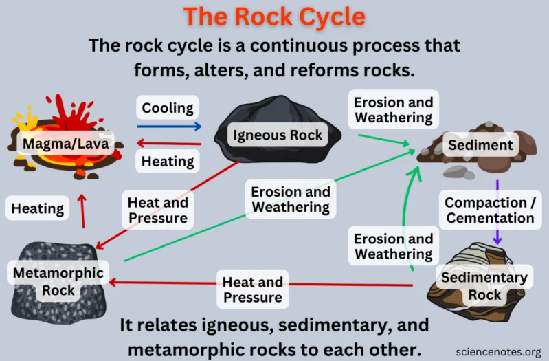
Rocks — Expanded Overview
Rocks record Earth’s processes: formation environment, tectonic history, climate signatures, and biological activity (via fossils in sedimentary rocks). They also control groundwater flow, soil formation, natural hazards, and resource distribution.
Key concepts to add: Texture (grain size, shape, arrangement), Mineralogy (what minerals are present), and Fabric (alignment/foliation).
Igneous Rocks — Additional Details
Classification by emplacement: Intrusive (plutonic) — magma cools slowly beneath the surface (large crystals; e.g., Granite, Gabbro). Extrusive (volcanic) — lava cools rapidly at the surface (fine-grained or glassy; e.g., Basalt, Rhyolite).
Textures: Phaneritic (coarse-grained, visible crystals), Aphanitic (fine-grained), Porphyritic (large crystals in fine matrix), Glassy (obsidian), Vesicular (contains gas holes; e.g., pumice, scoria).
Processes: Fractional crystallization, magma mixing, partial melting and assimilation of country rock influence composition.
Economic & engineering importance: Igneous intrusions form important ore deposits (e.g., porphyry copper). Basaltic plateaus (Deccan Traps, India) influence soil (black/cotton soil on basalt), groundwater, and engineering (foundations, rock slope stability).
Examples (global & India): Deccan Traps (India, Flood basalt – extensive extrusive basalt), the Peninsular Gneiss / Dharwar craton intrusions (ancient granitoids).
Sedimentary Rocks — Additional Details
Depositional environments: Fluvial (rivers — channel sands, conglomerates), Deltaic, Shallow marine (shelves — limestones, shales), Deep marine (turbidites), Lacustrine (lakes), Glacial (tillites), Evaporitic (salts, gypsum).
Sedimentary structures: Bedding/lamination, cross-bedding (indicative of current direction), ripple marks, graded bedding (turbidites), mud cracks, bioturbation structures, and imbrication (pebble alignment).
Diagenesis: Post-depositional processes (compaction, cementation, mineral replacement) that convert sediment to rock and change porosity/permeability — crucial for hydrocarbon reservoirs and aquifers.
Resources & environment: Sedimentary basins host coal, petroleum, natural gas, evaporite minerals (rock salt, potash), and aquifers. Example: Gondwana basins (India) — major coal deposits; Vindhyan (sedimentary sequences) and Bengal Fan (deep marine sediments).
Economic geology: Reservoir quality depends on grain size, sorting, cement; source rocks and seals control petroleum systems.
Metamorphic Rocks — Additional Details
Types of metamorphism: Contact (thermal) — due to intrusion heat (produces hornfels, marble near intrusions); Regional (dynamothermal) — due to tectonic burial and pressure over large areas (produces schist, gneiss); Hydrothermal — metasomatism by hot fluids (creates ore deposits); Shock — meteorite impact.
Metamorphic grade & index minerals: Low to high grade: chlorite → biotite → garnet → kyanite → sillimanite. Index minerals (garnet, staurolite, kyanite) help estimate pressure–temperature conditions.
Textures: Foliated (slate → phyllite → schist → gneiss) vs non-foliated (marble, quartzite).
Economic significance: Metamorphic belts often host economically important metamorphosed ore deposits (e.g., gold-bearing quartz veins), and building stones (marble, slate).
Indian examples: Archaean metamorphic terrains — Aravalli, Eastern Ghats (khondalites), high-grade gneiss terrains in Peninsular India.
Rock Cycle — Expanded Processes & Rates
Weathering → erosion → transport → deposition → burial → lithification → metamorphism → melting → magmatism → solidification. Rates vary: sedimentation can be meters/1000s years in rapid deltas, metamorphism occurs over millions of years, volcanic eruptions can form rock in hours/days.
Human timescale relevance: Some processes (soil formation, weathering) are rapid enough to affect agriculture and engineering within decades.
Weathering, Soil & Landscape Relationships
Weathering: Physical (freeze–thaw, exfoliation), chemical (hydrolysis, oxidation, dissolution), biological (root wedging). Rock type controls weathering products: basalt → clay + iron oxides (laterite); limestone → karst landscapes (caves, sinkholes).
Soils: Laterite (tropical, heavily leached, aluminium/iron-rich), Pedalfer (temperate), Pedocal (arid), Black cotton soil on basalt (vertisols).
Landscape control: Hard igneous rocks form high relief (mountains, escarpments); sedimentary layers form plateaus and basins; metamorphic belts form rugged, folded ranges.
Engineering & Environmental Significance
Rock type influences foundation design, tunnelling, slope stability, dam siting, groundwater potential and contaminant transport. Examples: Weathered basalts can cause anisotropic groundwater flow; shale zones may be slip planes in tunnels.
Mining & quarrying impacts: land degradation, acid mine drainage (sulphide oxidation), groundwater drawdown; sustainable extraction and rehabilitation are policy priorities.
Practical UPSC/Exam Cues & Examples
- Deccan Traps: basaltic flood lavas — influence soils (black soils), groundwater, and historical volcanism (end-Cretaceous debates).
- Gondwana coals: source of India’s major coal deposits — important for energy geography.
- Vindhyan & Siwalik: sedimentary sequences used in stratigraphic correlation and palaeoenvironmental reconstructions.
Useful Cross-References
Link rock types to: hydrogeology (aquifers), geomorphology (landform evolution), mineral resources and natural hazards (landslides, seismic response).
| Feature | Igneous Rocks | Sedimentary Rocks | Metamorphic Rocks |
|---|---|---|---|
| Origin | Cooling/solidification of magma/lava | Deposition of sediments; diagenesis | Alteration of pre-existing rocks by heat/pressure/fluids |
| Textures | Phaneritic/Aphanitic/Porphyritic/Vesicular | Layered/Laminated; graded, cross-beds | Foliated (schistosity) or non-foliated |
| Environment Indicators | Plutonic depth, volcanic settings | River/delta/marine/lake/glacial/evaporite | Tectonic belts, contact aureoles |
| Economic Resources | Ore deposits (porphyry copper), dimension stone | Fossil fuels, evaporites, aquifers | Metamorphosed ores, building stone |
| Engineering Concerns | Jointing, columnar jointing (basalt), weathering profiles | Layering leads to differential erosion; weak shale layers | Cleavage/folds create planes of weakness |
| Original Rock | Type | Metamorphic Form |
|---|---|---|
| Limestone | Sedimentary | Marble |
| Dolomite | Sedimentary | Marble |
| Sandstone | Sedimentary | Quartzite |
| Shale | Sedimentary | Slate |
| Granite | Igneous | Gneiss |
| Slate | Metamorphic | Schist/Phyllite |
| Phyllite | Metamorphic | Schist |
Prelims tips
- Igneous texture tells cooling history: phaneritic = slow cooling (intrusive); aphanitic = rapid cooling (extrusive).
- Cross-bedding indicates current/wind direction — useful in palaeocurrent reconstructions.
- Index minerals (garnet, kyanite, sillimanite) indicate metamorphic pressure–temperature conditions.
- Diagenesis reduces porosity; reservoir quality depends on cement and sorting.
- Indian examples for memory: Deccan Traps (Basalt), Gondwana (Coal), Aravalli/Eastern Ghats (metamorphic terrains).
Mains points
- Integrated Earth Systems: Rocks link tectonics, climate and life — sedimentary records preserve paleoclimate and fossils; igneous activity relates to magmatism and mantle processes; metamorphism records tectonic convergence.
- Resource & Policy: Sustainable mining of rock resources (minerals, aggregates, fossil fuels) needs environmental safeguards — watershed protection, controlled blasting, acid-mine drainage mitigation, and post-mining land restoration.
- Engineering Geology: Rock-type knowledge is essential for infrastructure planning (dams, tunnels, urban expansion) — mapping lithology, joints, foliation and weathering profiles reduces failure risk.
- Geoheritage & Economy: Rock formations (Deccan Traps, fossiliferous sequences) are geoheritage sites and support tourism; dimension stone/quarrying supplies construction industry — balancing economy and conservation is a policymaker’s task.
Indian & Physical Geography: All chapters
- The Universe and the Earth
- Atmosphere and Its Composition
- Atmospheric Temperature
- Atmospheric Moisture
- Air Mass, Fronts & Cyclones
- Evolution of Earth's Crust, Earthquakes and Volcanoes
- Interior of the Earth
- Landforms
- Geomorphic Processes
- Movement of Ocean Water
- Oceans and Their Properties
- Climate of a Region
- Indian Geography: Introduction and Geology
- Physiography of India
- Indian Climate
- Indian Drainage
- Soil and Natural Vegetation
- Mineral and Energy Resources, Industries in India
- Indian Agriculture
- Population, Migration and Urbanisation