
Indian & Physical Geography · UPSC Notes
Physiography of India — UPSC Geography Notes
Free, exam-focused notes for UPSC Prelims and Mains, with Prelims tips and Mains points for every topic. 28 topics.
Open in the interactive reader: bookmarks, progress tracking and read-aloud.
Himalayas
The Himalayas (meaning 'Abode of Snow') are the world’s youngest, highest, and longest fold mountain system, formed through the collision of the Indian Plate with the Eurasian Plate. They continue to rise due to ongoing plate tectonics.
Origin of the Himalayas
Based on Continental Drift Theory and Plate Tectonics.
About 200 million years ago: The supercontinent Pangea split into Laurasia (North) and Gondwanaland (South).
A long ocean called the Tethys Sea existed between them, where thick layers of sediments and marine organisms accumulated for millions of years.
The Indian Plate broke away from Gondwanaland and drifted northward at a fast rate.
Around 50 million years ago, the Indian Plate collided with the Eurasian Plate.
Since both plates are continental and light, no subduction occurred. Instead, the Tethys Sea sediments were compressed and folded upward to form the Himalayas.
Thus, the Himalayas are an example of continent–continent convergence.
Geological Evidence
Marine fossils such as ammonites and shells found in the Himalayas prove that the region was once covered by the Tethys Sea.
Presence of rock formations from Precambrian to recent times shows continuous geological evolution.
Highly folded, uplifted, and faulted rocks indicate strong compressional forces typical of convergent boundaries.
Evidence That the Himalayas Are Still Rising
The Indian Plate continues to move northwards at about 5 cm per year, pushing the Himalayas upward.
Similar fossils found in the Shiwalik hills and Tibetan Plateau indicate uplift over time.
Ancient lake deposits in Tibet show that large freshwater lakes once existed but drained as the land rose.
The Himalayas are among the most seismically active regions of the world due to ongoing plate collision.
Rivers like the Indus, Ganga, and Brahmaputra carve deep V-shaped valleys, proving the mountains are still rising and young.
Physiographic Divisions of the Himalayas
Trans-Himalayas: Includes Karakoram, Ladakh, and Zaskar ranges; dry, cold, and high-altitude region.
Greater Himalayas (Himadri): Highest range; contains Mt. Everest, Kanchenjunga; has permanent snow and glaciers.
Lesser Himalayas (Himachal): Includes Pir Panjal and Dhauladhar; contains hill stations like Shimla and Mussoorie.
Shiwaliks: Youngest Himalayas; made of loose sediments; prone to landslides; contain longitudinal valleys (Duns).
Eastern Hills (Purvanchal): Includes Patkai, Naga, Mizo, and Manipur hills; formed by bending of Himalayas towards the south.
Significance of the Himalayas
Climatic Barrier: Protects India from cold Siberian winds; causes orographic rainfall during monsoon.
Source of Major Rivers: Indus, Ganga, Yamuna, and Brahmaputra originate from Himalayan glaciers.
Biodiversity Hotspot: Home to diverse flora and fauna like snow leopard, red panda, medicinal plants.
Natural Resources: Forests, herbs, minerals (limited), and vast hydropower potential.
Strategic Importance: Forms a natural frontier with China, Nepal, and Bhutan; crucial for national security.
Cultural Importance: Includes sacred sites like Kailash, Amarnath, Kedarnath, and Mansarovar.
| Aspect | Details |
|---|---|
| Meaning of Name | Himalaya = Abode of Snow |
| Type | Young fold mountain system |
| Age | Formed ~40–50 million years ago |
| Origin | Collision of Indian & Eurasian Plates |
| Geological Evidence | Marine fossils, folded sediments |
| Ongoing Rise | Indian Plate moves ~5 cm/year |
| Divisions | Trans, Greater, Lesser, Shiwaliks, Purvanchal |
| Importance | Climate, rivers, biodiversity, culture, defense |
Prelims tips
- Himalayas are the youngest fold mountains (~50 million years old).
- Formed by collision of Indian Plate with Eurasian Plate (Continental Drift Theory).
- Divisions: Trans, Greater (Himadri), Lesser (Himachal), Shiwaliks, Purvanchal.
- Indian Plate still moving northwards at ~5 cm/year.
- Marine fossils in Himalayas indicate Tethys Sea origin.
Mains points
- Himalayas are a product of plate tectonics and continental drift.
- They continue to rise due to northward movement of the Indian Plate.
- They play a critical role in India’s climate, river systems, biodiversity, and defense.
- Frequent earthquakes highlight tectonic instability in the region.
- Physiographic divisions show geological diversity and ecological significance.
- Himalayas symbolize cultural and spiritual heritage of India.
Characteristic Features of the Himalayas (Beginner's Guide)
The Himalayas are a massive chain of young mountains stretching 2400 km like a sword or a bow. They are unique because they are asymmetrical—very steep towards India (South) but gentle towards Tibet (North). They act as a physical barrier linked to the 'Roof of the World' (Pamir Knot).
1. Extension (How long is it?)
Imagine a giant arc or a bow stretched across the top of India.
Total Length: It runs for about 2400 km.
Start & End Points:
- West: Starts at the Indus Gorge (a deep valley cut by the Indus river in Ladakh/POK).
- East: Ends at the Dihang/Brahmaputra Gorge (in Arunachal Pradesh).
2. Width Variation (The Funnel Shape)
The Himalayas are not the same thickness everywhere. They are shaped like a funnel—wide at one end and narrow at the other.
West (Kashmir): Very wide, approx 400 km.
East (Arunachal Pradesh): Squeezed and narrow, approx 150 km.
Key Concept: Because the Eastern part is squeezed into a smaller space, the pressure pushed the land higher. This is why the highest peaks (like Mt. Everest and Kanchenjunga) are mostly in the East/Central part, not in the wide West.
3. Link with Central Asia (The Connection)
The Himalayas don't stand alone. They are connected to a central point called the Pamir Knot.
Analogy: Think of the Pamir Knot as the hub of a wheel, and different mountain ranges (Himalayas, Karakoram, Kunlun, Hindu Kush) are the spokes radiating out from it.
4. Syntaxial Bends (The Sharp U-Turns)
At both the Western and Eastern ends, the Himalayan range takes a sudden, sharp turn towards the South. These are called Syntaxial Bends.
Why? It is like bending a steel rod. The tectonic force from the Indian plate was strongest at these corners.
- Western Bend: Happens near Nanga Parbat. The mountains turn south into Pakistan.
- Eastern Bend: Happens near Namcha Barwa. The mountains turn south into Myanmar.
5. Topography & Slopes ( The Asymmetry)
The Himalayas are Asymmetrical, meaning the two sides do not look the same.
Southern Slope (Facing India): steep, almost vertical wall. This makes it very hard to climb from the Indian side.
Northern Slope (Facing Tibet): gentle, gradual slope. It merges slowly into the Tibetan Plateau.
Geological Reason: The Indian tectonic plate is diving (subducting) steeply under the Eurasian plate, creating this vertical rise on the Indian front.
6. High Elevation Peaks
This range houses the world's tallest points.
Counts: It has 14 peaks taller than 8000 meters and 20 peaks taller than 7500 meters.
Famous Names: Mt. Everest, Kanchenjunga, Makalu, Dhaulagiri, Nanga Parbat, Annapurna.
| Feature | Specific Details | Geological Significance |
|---|---|---|
| Extension | 2400 km long (Indus Gorge to Brahmaputra Gorge) | Acts as a climatic and physical barrier for India. |
| Width | West: 400 km (Wide); East: 150 km (Narrow) | Wider base in West means lower height; Narrow base in East means higher peaks. |
| Linkage | Connected to 'Pamir Knot' (Roof of the World) | Part of the greater Alpide belt connecting to Central Asia. |
| Syntaxial Bends | 1. Nanga Parbat (NW), 2. Namcha Barwa (NE) | Marks the ends of the range where the rock structure bends sharply south. |
| Peaks | 14 peaks > 8000m; 20 peaks > 7500m | Highest young fold mountains in the world. |
| Topography | Deep valleys, Gorges, Youthful rivers | Shows that the mountains are still rising (Youthful stage). |
| Slopes | South: Steep/Abrupt; North: Gentle | Result of the Indian Plate pushing under the Tibetan Plate. |
Prelims tips
- Bend Locations: Remember the names—Nanga Parbat is the West anchor, Namcha Barwa is the East anchor.
- River Gorges: The Indus cuts the gorge in the West, and the Brahmaputra (Dihang) cuts the gorge in the East.
- Slope Trick: If a statement says 'Himalayas have gentle slopes towards India', it is FALSE.
- Width Logic: West is Wide (W-W). East is elevated (High Peaks).
Mains points
- Impact of Syntaxial Bends: These bends channel the Monsoon winds into the Indian subcontinent, ensuring rainfall.
- Defense Barrier: The steep southern slope makes invasion from the north historically difficult.
- River Potential: The steep drop causes rivers to flow very fast, giving India massive Hydropower potential.
- Seismic Activity: The unstable topography and ongoing 'push' make this region prone to earthquakes.
Tuting-Tidding Suture Zone & Divisions of the Himalayas (Beginner's Guide)
The Tuting-Tidding Suture Zone (TTSZ) is a special area in Arunachal Pradesh where the Himalayan mountains take a sharp turn towards the south, connecting with the mountains of Myanmar. The Himalayas are not just one mountain range but are divided into 4 parallel layers from North to South: Trans Himalayas, Greater Himalayas, Lesser Himalayas, and Outer Himalayas.
1. What is the Tuting-Tidding Suture Zone (TTSZ)?
Imagine two pieces of cloth stitched together. The line where they join is called a 'Suture'. similarly, in geology, a Suture Zone is where two continental plates meet.
Location: It is found in the far eastern part of India, in Arunachal Pradesh.
What happens here? This is the exact spot where the massive Himalayan chain bends sharply southwards to merge with the Indo-Burma ranges (mountains of Northeast India and Myanmar).
Why is it important? It is a zone of 'Tectonic Convergence', meaning the earth's plates are still pushing against each other here, making it prone to earthquakes.
2. North-South Divisions of Himalayas (The Layer Cake)
If you travel from China (North) towards India (South), you will cross 4 distinct mountain belts:
A. Trans Himalayas (Tibetan Himalayas): The mountains 'behind' the main Himalayas.
B. Greater Himalayas (Himadri): The highest, snowy peaks like Everest.
C. Lesser Himalayas (Himachal): The popular hill stations like Shimla and Mussoorie.
D. Outer Himalayas (Shiwalik): The lowest foothills nearest to the plains.
3. Deep Dive: The Trans Himalayas
Meaning: 'Trans' means 'Beyond'. These mountains are located behind the Great Himalayas.
Geography: They are mostly in Tibet (China) and Ladakh (India). They are roughly 1000 km long and 40-225 km wide.
Key Feature: They lie in the 'Rain Shadow' zone, meaning monsoon clouds act blocked by the Great Himalayas, so this area is a cold desert (like Ladakh).
4. Important Ranges of Trans Himalayas
The Trans Himalayas are made up of 4 major ranges (Remember 'KLZ' - Karakoram, Ladakh, Zaskar):
A. Karakoram Range (The Backbone)
- Position: Northernmost range. It acts as a border between India, Pakistan, and China.
- Star Peak: Home to K2 (Godwin-Austen), which is 8611m high. It is the 2nd highest peak in the world and the highest in the Indian territory (POK).
- Glaciers: It has the largest glaciers outside the Polar regions, such as the Siachen Glacier.
B. Ladakh Range
- Position: Located south of Karakoram and north of the Indus river.
- Landscape: It merges into the Ladakh Plateau, which includes plains like Aksai Chin and Depsang.
C. Zaskar Range
- Position: Located south of the Ladakh range.
- Significance: It forms the border between the Ladakh region and the rest of Jammu & Kashmir.
D. Kailash Range
- Position: An extension of the Ladakh range into Western Tibet.
- Significance: Home to Mount Kailash and Lake Mansarovar, which are sacred to Hindus, Buddhists, and Jains.
| Division Name | Also Known As | Average Height | Key Features & Ranges |
|---|---|---|---|
| 1. Trans Himalayas | Tibetan Himalayas | 3000 m | Found in Ladakh/Tibet. Includes Karakoram (K2 Peak), Ladakh, and Zaskar ranges. Cold desert climate. |
| 2. Greater Himalayas | Himadri (Abode of Snow) | 6000 m | The highest continuous wall. Contains Mt. Everest, Kanchenjunga, Nanga Parbat. Always snow-covered. |
| 3. Lesser Himalayas | Himachal / Middle Himalayas | 3500 - 4500 m | Famous for hill stations (Shimla, Darjeeling). Ranges: Pir Panjal, Dhauladhar. Gentle slopes with forests. |
| 4. Outer Himalayas | Shiwalik | 900 - 1200 m | The youngest part. Made of loose mud and rocks (unconsolidated sediments). Prone to landslides. |
Prelims tips
- Correct Order (North to South): Karakoram -> Ladakh -> Zaskar -> Pir Panjal -> Shiwalik.
- Highest Peak Confusion: World's highest is Everest (Nepal). India's highest is K2 (POK). India's highest undisputed (within current control) is Kanchenjunga (Sikkim).
- Glaciers: Siachen, Baltoro, and Biafo glaciers are found in the Karakoram range, not the Great Himalayas.
- Suture Zone: TTSZ is in Arunachal Pradesh, NOT in Kashmir.
Mains points
- Strategic Importance: The Trans Himalayas (especially Karakoram & Ladakh) act as a high-altitude defense line between India, Pakistan, and China.
- Water Security: The glaciers in the Trans and Greater Himalayas are the source of major rivers (Indus, Ganga, Brahmaputra) that feed millions.
- Seismic Risk: The Tuting-Tidding Suture Zone highlights the active tectonic nature of the North-East, making disaster management crucial there.
- Tourism Potential: The contrast between the cold desert of Ladakh (Trans Himalayas) and the green forests of Himachal (Lesser Himalayas) offers diverse tourism opportunities.
Divisions of the Himalayas: Greater, Lesser & Outer (Beginner's Guide)
Think of the Himalayas not as one mountain, but as a Three-Step Staircase rising from the Indian plains towards China. The lowest step is the Shiwalik (Outer), the middle step is the Lesser Himalayas (Himachal), and the highest step is the Great Himalayas (Himadri). Together, they form the physical backbone of India.
1. The Concept of Three Parallel Ranges
If you slice the Himalayas from North to South, you won't see just one peak. You will see three distinct parallel lines of mountains.
Order from North to South:
1. Greater Himalayas (Highest, snowy, oldest)
2. Lesser Himalayas (Rugged, hill stations)
3. Outer Himalayas (Lowest, muddy, youngest)
2. The Greater Himalayas (Himadri)
Also known as: Inner Himalayas or Himadri (Sanskrit for 'Abode of Snow').
Location: The northernmost wall.
Key Features for Beginners:
- The Solid Wall: It is the most continuous range. There are very few gaps (passes) to cross it.
- The Core: Inside these mountains, the rock is hard Granite. This strong core helps them stand so tall.
- Asymmetry: The side facing India is very steep (like a wall), while the side facing Tibet slopes down gently.
- Famous Peaks: This range holds Mt. Everest (8848m), Kanchenjunga, and Nanga Parbat.
3. The Lesser Himalayas (Himachal)
Also known as: Middle Himalayas.
Location: Sandwiched between the Great Himalayas (North) and Shiwaliks (South).
Key Features for Beginners:
- The Tourist Belt: Most famous hill stations like Shimla, Mussoorie, Nainital, and Darjeeling are located here because the height (3700-4500m) is pleasant, not freezing like Himadri.
- The Vegetation Mystery:
- North-facing slopes: Have dense forests (because they get less direct sun, so soil stays moist).
- South-facing slopes: Are steep and often bare/grassy (because direct sun dries them out).
- Major Ranges: The Pir Panjal (Kashmir) and Dhauladhar (Himachal) are parts of this layer.
4. The Outer Himalayas (Shiwalik)
Also known as: The Foothills or Manak Parbat.
Location: The southernmost edge, right next to the plains of UP, Punjab, etc.
Key Features for Beginners:
- The Youngest: These mountains formed last.
- Made of 'Debris': While Himadri is made of hard rock, Shiwalik is made of loose mud, gravel, and stones brought down by rivers from the upper mountains. Because the soil is loose, Landslides are very common here.
- Disappearing Act: The Shiwalik range is wide in the West (Himachal/Punjab) but becomes very narrow or merges completely with the Lesser Himalayas in the East (Arunachal Pradesh).
5. Important Geographical Terms (The 'Duns' and 'Chos')
A. What is a 'Dun'?
- Imagine a flat valley nestled lengthwise between the Lesser Himalayas and the Shiwaliks. This structural valley is called a 'Dun'.
- Example: Dehra-dun, Patli-dun.
B. What is a 'Duar'?
- In the East (Bengal/Assam), these flat foothills are called 'Duars' (meaning 'Doors' to Bhutan). They are famous for Tea Gardens.
C. What are 'Chos'?
- In Punjab and Himachal, during monsoons, temporary streams rush down the Shiwalik slopes, cutting deep gullies in the soft soil. These destructive streams are called Chos.
| Range Name | Avg Height | Composition (Made Of) | Famous For |
|---|---|---|---|
| Greater (Himadri) | 6000 m (Highest) | Granite (Hard Rock) | Mt. Everest, Glaciers (Siachen), & Perpetual Snow. |
| Lesser (Himachal) | 3700–4500 m | Metamorphic Rocks | Hill Stations (Shimla, Mussoorie), Valleys (Kullu). |
| Outer (Shiwalik) | 900–1100 m (Lowest) | Loose Mud & Stones | Duns (Dehradun) & Foothills prone to landslides. |
Prelims tips
- Sequence Rule: Always remember the order North to South: Himadri -> Himachal -> Shiwalik.
- The Missing Link: The Shiwalik range is NOT continuous. It disappears near the Tista river in the East.
- Soil Type: Shiwalik = Unconsolidated (Loose) sediments. Himadri = Granite (Hard).
- Karewas: The Kashmir Valley (Lesser Himalayas) is famous for 'Karewa' soil deposits, which are excellent for growing Saffron (Zafran).
Mains points
- Tourism vs Ecology: The Lesser Himalayas are under huge stress due to tourism (hotels/roads). Discuss the need for sustainable tourism.
- Disaster Management: The Shiwaliks are made of loose soil. Explain why road construction here leads to frequent landslides during monsoons.
- Hydro Potential: The steep drop from Greater to Lesser Himalayas creates fast-flowing rivers, ideal for Hydroelectric Power Plants.
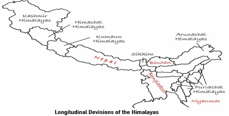
Longitudinal Divisions of the Himalayas (West to East)
Instead of looking at the Himalayas from North to South (Layers), we can slice them from West to East based on the rivers that divide them. This divides the Himalayas into 4-5 distinct sections, each with its own culture and geography.
1. The Concept of River Borders
Geologist Sir Sidney Burrard divided the Himalayas vertically using rivers as boundaries. Imagine the rivers are the knife cuts slicing a long cake.
The Flow: We move from the West (Indus River) to the East (Brahmaputra River).
Major Sections:
1. Kashmir/Punjab Himalayas
2. Kumaon Himalayas
3. Nepal Himalayas
4. Assam Himalayas
5. Purvanchal (Eastern Hills)
2. Kashmir or Punjab Himalayas
Location: Between Indus River and Sutlej River.
States Covered: Jammu & Kashmir, Ladakh, and parts of Himachal Pradesh.
Key Features:
- Width: This is the widest part of the Himalayas.
- Landscapes: Famous for the 'Vale of Kashmir' (Kashmir Valley) and cold deserts like Ladakh.
- Cultivation: Famous for Saffron (Zafran) cultivation in the Karewa soil formations.
3. Kumaon Himalayas
Location: Between Sutlej River and Kali River.
States Covered: Uttarakhand.
Key Features:
- Religious Hub: This area is known as 'Devbhoomi' (Land of Gods). It contains the sources of Ganga (Gangotri) and Yamuna (Yamunotri).
- Peaks: Nanda Devi (Highest in Uttarakhand), Kamet, and Trishul.
- Lakes: Famous for lake cities like Nainital and Bhimtal.
4. Nepal Himalayas (The Central Part)
Location: Between Kali River and Tista River.
States/Country: Mostly in Nepal, small part in Sikkim and West Bengal.
Key Features:
- The Giants: This is the tallest section. It contains Mt. Everest, Kanchenjunga, and Makalu.
- Structure: Very steep and rugged. The mountains are squeezed tight here.
- Passes: Important trade routes like Nathu La and Jelep La connect Sikkim to Tibet.
5. Assam Himalayas
Location: Between Tista River and Brahmaputra (Dihang) River.
States Covered: Arunachal Pradesh and Bhutan.
Key Features:
- Rain & Greenery: This region receives very heavy rainfall.
- Narrow: The Himalayas become much narrower here compared to the West.
- Tribal Culture: Home to diverse tribes like Monpa, Abor, and Mishmi.
6. Purvanchal (The Eastern Hills)
Location: Beyond the Dihang Gorge, the Himalayas bend sharply to the South.
States Covered: Nagaland, Manipur, Mizoram, Tripura, Meghalaya.
Key Features:
- Not Snow, But Forest: Unlike the snowy North, these are lower hills covered in thick, green jungles.
- Structure: They run North to South (unlike the main Himalayas which run West to East).
- Names: They are named after local tribes (Patkai Bum, Naga Hills, Mizo Hills).
| Division Name | River A (Start) | River B (End) | Famous Landmark |
|---|---|---|---|
| Punjab/Kashmir Himalayas | Indus | Sutlej | Vaishno Devi, Dal Lake |
| Kumaon Himalayas | Sutlej | Kali | Nanda Devi, Valley of Flowers |
| Nepal Himalayas | Kali | Tista | Mt. Everest, Kathmandu |
| Assam Himalayas | Tista | Brahmaputra | Namcha Barwa, Kaziranga (Foothills) |
Prelims tips
- River Sequence: Memorize the rivers West to East: Indus -> Sutlej -> Kali -> Tista -> Brahmaputra.
- Highest Peak in India: K2 is in Kashmir Himalayas (POK), but Kanchenjunga is in the Eastern (Sikkim) Himalayas.
- Mizo Hills: Also known as 'Lushai Hills'. They are part of Purvanchal.
- Loktak Lake: Famous floating lake located in Manipur (Purvanchal Hills).
Mains points
- Cultural Diversity: Explain how the Western Himalayas are influenced by Central Asian culture, while the Eastern Himalayas have strong Tibeto-Burman tribal influences.
- Biodiversity Hotspot: The Eastern Himalayas and Purvanchal are among the world's biodiversity hotspots due to high humidity and density.
- Insurgency Issues: The rugged terrain and dense forests of Purvanchal have historically made it difficult to police, aiding insurgency movements.
Western, Eastern & North-Eastern Himalayas (West-to-East Journey)
The Himalayas are vast, so geographers divide them from West to East based on river boundaries. This includes the rugged Western Himalayas (Kashmir/Uttarakhand), the towering Eastern Himalayas (Nepal/Sikkim/Arunachal), and the lush green North-Eastern Hills (Purvanchal).
1. Western Himalayas
This section covers the states of Jammu & Kashmir, Ladakh, and Himachal Pradesh.
A. Punjab Himalayas (Kashmir & Himachal)
Location: Between the Indus River and Sutlej River.
Key Features:
- Ranges: It contains the widest ranges like Karakoram, Ladakh, Pir Panjal, and Zaskar.
- The Karewas (Nature's Flower Pot):
- Imagine a massive lake on top of the mountains millions of years ago. When it dried up, it left behind thick layers of clay and sand. These flat, table-top lands are called Karewas.
- Why important? They are super fertile and used to grow Saffron (Zafran) and Apples.
B. Kumaon Himalayas (Uttarakhand)
Location: Between the Sutlej River and Kali River.
Key Features:
- The Holy Land: Known as 'Devbhoomi'. It is the source of the holy rivers Ganga (Gangotri) and Yamuna (Yamunotri).
- Peaks: Nanda Devi (India's 2nd highest peak), Kamet, and Trishul.
- Passes: Lipulekh Pass (used for the Kailash-Mansarovar Yatra).
2. Eastern Himalayas
This section starts from the border of Nepal and stretches up to Arunachal Pradesh. It is known for having the highest peaks.
A. Nepal Himalayas
Location: Between Kali River and Kosi River.
Significance: This is the tallest section of the Himalayas.
- Giants: Mt. Everest (8848m), Makalu, Dhaulagiri, and Annapurna are all here.
B. Sikkim Himalayas
Location: Between Kosi River and Teesta River.
Significance:
- It is a small but very steep section.
- Home to Kanchenjunga (India's highest undisputed peak).
- Trade Route: The Jelep-La Pass here is a historic trade route connecting India, China, and Bhutan.
C. Assam Himalayas (Arunachal Pradesh)
Location: Between Teesta River and Dihang (Brahmaputra) River.
Significance:
- Rain & Greenery: Unlike the dry West, this area gets heavy rainfall and is covered in thick forests.
- Major Peak: Namcha Barwa (7782m).
- Tri-junction: The Diphu Pass marks the meeting point of India, China, and Myanmar.
3. North-Eastern Hills (Purvanchal)
The Big Bend: After crossing the Dihang Gorge in Arunachal Pradesh, the Himalayan range takes a sharp 'Hairpin Turn' towards the South. This extension is called Purvanchal.
Key Characteristics:
- Low Hills: These are not snowy mountains but low hills (2000-3000m) covered in dense tropical forests.
- Major Hills:
- Patkai Bum (Arunachal)
- Naga Hills (Nagaland)
- Manipur Hills (Manipur)
- Mizo Hills (Mizoram - formerly Lushai Hills)
- Geological Connection: These hills continue downwards into Myanmar as the Arakan Yoma range and then dive into the sea, re-emerging as the Andaman & Nicobar Islands.
| Region | River Borders | Famous For... |
|---|---|---|
| Punjab/Kashmir | Indus - Sutlej | Karewas (Saffron), Cold Deserts (Ladakh), Vaishno Devi. |
| Kumaon (UK) | Sutlej - Kali | Pilgrimage (Gangotri/Yamunotri), Nainital Lake, Nanda Devi. |
| Nepal | Kali - Kosi | World's Highest Peaks (Everest). |
| Sikkim | Kosi - Teesta | Kanchenjunga, Organic Farming, Biodiversity. |
| Assam (Arunachal) | Teesta - Brahmaputra | First Sunrise (Dong), Namcha Barwa, Heavy Rain. |
| Purvanchal | South of Brahmaputra | Mizo Hills (Bamboo forests), Loktak Lake (Manipur). |
Prelims tips
- Passes Match: Lipulekh (Uttarakhand), Jelep La (Sikkim), Diphu (Arunachal).
- The Andaman Link: Remember that Andaman & Nicobar islands are actually the peaks of the submerged continuation of the Purvanchal (Arakan Yoma) range.
- Karewa Soil: Specifically found in Kashmir Himalayas. Keywords: 'Lacustrine deposits' (Lake deposits) and 'Saffron' (Zafran).
- Mizo Hills: Formerly called 'Lushai Hills'. They are part of the Purvanchal system, not the Main Himalayas.
Mains points
- Strategic Importance: The Western Himalayas (Siachen/Kashmir) face security threats from Pakistan/China, while the Eastern Himalayas (Doklam/Tawang) face border disputes with China.
- Insurgency & Geography: The dense forests and porous borders of Purvanchal make it prone to insurgency and drug trafficking (Golden Triangle proximity).
- Economic Contrast: Western Himalayas rely on horticulture (apples) and tourism, while Eastern Himalayas have potential for Tea cultivation and Hydro-power due to fast-flowing rivers.
Comparison: Western vs. Eastern Himalayas (Beginner's Guide)
The Himalayas are not the same everywhere. The Western part (Kashmir/Uttarakhand) is wider, drier, and colder. The Eastern part (Sikkim/Arunachal) is narrower, steeper, and receives heavy rainfall. This difference affects everything from how the mountains look to where the snow starts.
1. Location & Extent (Where are they?)
Western Himalayas: Stretch from the Indus River to the Kali River (Border of Nepal). It covers Kashmir, Himachal, and Uttarakhand.
Eastern Himalayas: Stretch from the Kali River to the Brahmaputra (Dihang) River. It covers Nepal, Sikkim, Bhutan, and Arunachal Pradesh.
2. Width & Steepness (The Shape)
Western: These mountains are Very Wide. The slope is gradual. You can drive up slowly (like the road to Ladakh).
Eastern: These mountains are Narrow and Squeezed. Because they are squeezed, they rise abruptly from the plains. The slope is very steep.
3. Climate (Wet vs. Dry)
Western: Far from the sea. The climate is drier and colder. This is why you find 'Cold Deserts' like Ladakh here.
Eastern: Closer to the Bay of Bengal. It gets huge amounts of moisture and rain. This makes it humid and green.
4. The Snowline Mystery (Crucial Concept)
What is a Snowline? It is the altitude above which snow never melts (permanent snow).
Western Himalayas: The Snowline is LOWER. Why? Because this region is further North (higher latitude), so it is colder. Snow doesn't melt even at lower heights.
Eastern Himalayas: The Snowline is HIGHER. Why? Because this region is closer to the Equator (lower latitude), so it is warmer. You have to climb very high to find permanent snow.
5. Vegetation (Biodiversity)
Western: Less vegetation. You see Pine and Deodar trees, and brown barren lands at higher heights.
Eastern: Thick, dense tropical forests. It is a Biodiversity Hotspot rich in orchids, ferns, and red pandas because of the heavy rain.
| Feature | Western Himalayas | Eastern Himalayas |
|---|---|---|
| Width | Very Wide (Spread out) | Narrow (Compressed) |
| Rainfall | Low (Drier) | Very High (Wet & Humid) |
| Snowline | Lower (Snow starts early) | Higher (Snow starts late) |
| Nature | Alpine & Coniferous forests | Dense Evergreen forests (Biodiversity Hotspot) |
| Famous Peaks | Nanda Devi, K2 (POK) | Mt. Everest, Kanchenjunga |
Prelims tips
- Snowline Trick: Remember, West is Colder = Snowline is Lower. East is Warmer = Snowline is Higher.
- Biodiversity: The Eastern Himalayas are one of the global 'Biodiversity Hotspots'. The Western Himalayas are NOT.
- The Rivers: The Western rivers (Indus system) flow into the Arabian Sea. The Eastern rivers (Brahmaputra/Ganga system) flow into the Bay of Bengal.
Mains points
- Impact on Agriculture: Explain why Western Himalayas grow apples and saffron (dry/cold crops), while Eastern Himalayas grow tea and rice (wet/warm crops).
- Infrastructure Challenge: Discuss why building roads is harder in the Eastern Himalayas due to sudden steep slopes and heavy rain causing landslides.
- Climate Change: Mention how the receding snowline in both regions is affecting river water flow.
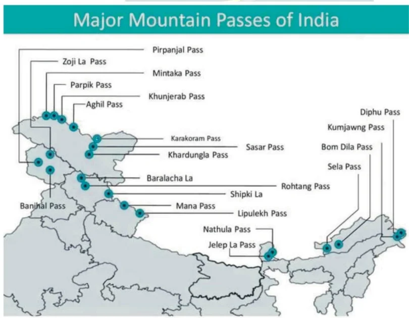
Passes in the Himalayas
A Pass (often called 'La' in Tibetan) is a natural gap or low point in a mountain range that allows people to cross from one side to the other. Without these passes, the Himalayas would be a giant wall impossible to cross. They are the lifelines for trade, military, and travel.
1. What is a Mountain Pass?
Think of a mountain range as a high wall. A Pass is like a 'Door' or 'Gate' in that wall.
Origin of the word 'La': In the Himalayas, you will hear names like Zoji La, Nathu La. The word 'La' literally means 'Pass'. So saying 'Zoji La Pass' is actually saying 'Zoji Pass Pass'!
2. Passes in J&K and Ladakh (The Western Gateways)
This region is critical for defense and connects India to Central Asia.
A. Banihal Pass (J&K):
- Connects: Jammu to Srinagar (Kashmir Valley).
- Significance: It remains open mostly year-round due to the Jawahar Tunnel. It is the main entry into Kashmir.
B. Zoji La (Ladakh):
- Connects: Srinagar to Leh (Ladakh).
- Significance: Known as the 'Gateway to Ladakh'. It is strategically vital for the military to send supplies to Ladakh/Kargil.
C. Khardung La (Ladakh):
- Connects: Leh to Siachen Glacier.
- Fame: Famous as one of the highest motorable roads in the world. Bikers love this route.
3. Passes in Himachal Pradesh (The Tourist & Trade Routes)
A. Rohtang Pass:
- Connects: Kullu Valley to Lahaul & Spiti.
- Significance: Very famous for tourism. However, it gets blocked by snow in winter. The new Atal Tunnel now goes under this pass to provide all-weather connectivity.
B. Shipki La:
- Connects: Shimla (India) to Tibet (China).
- Significance: This is where the mighty River Sutlej enters India from Tibet.
C. Baralacha La:
- Connects: Mandi (HP) to Leh (Ladakh).
- Significance: It is a high-altitude crossroads connecting three different mountain ranges.
4. Passes in Uttarakhand (The Pilgrim Routes)
A. Lipulekh Pass:
- Connects: Uttarakhand to Tibet.
- Significance: It is located at the tri-junction of India, Nepal, and China. Famous for the Kailash-Mansarovar Yatra.
B. Mana Pass & Niti Pass:
- Connects: Uttarakhand to Tibet.
- Significance: Mana is often called the 'Last Village of India'.
5. Passes in the North-East (Sikkim & Arunachal)
These passes are crucial for trade with China and Myanmar.
A. Nathu La (Sikkim):
- Connects: Sikkim to Tibet.
- History: Part of the ancient Silk Route. It was closed after the 1962 war but reopened in 2006 for trade. It is a major border personnel meeting point.
B. Jelep La (Sikkim):
- Connects: Sikkim to Lhasa (Tibet).
- Geography: Passing through the Chumbi Valley.
C. Bom Di La (Arunachal Pradesh):
- Connects: Arunachal to Lhasa (Tibet).
D. Diphu Pass (Arunachal Pradesh):
- Significance: Tri-junction of India, China, and Myanmar.
| Pass | Location | Connectivity/Importance |
|---|---|---|
| Pir Panjal | J&K | Connects Jammu with Kashmir Valley |
| Banihal | J&K | Links Jammu and Srinagar (now tunnel) |
| Burzil | J&K | Srinagar–Gilgit; connects to Deosai Plains |
| Zoji La | J&K (Zaskar Range) | Connects Srinagar to Leh (strategic Ladakh route) |
| Shipki La | Himachal Pradesh | Sutlej River passes; connects Shimla to Tibet |
| Baralacha La | Himachal Pradesh | Mandi to Leh road link |
| Rohtang | Himachal Pradesh | Connects Manali to Leh |
| Niti | Uttarakhand | Route to Kailash–Mansarovar |
| Nathu La | Sikkim | Connects Darjeeling (India) with Tibet; Indo-China trade |
| Jelep La | Sikkim (Tri-junction) | India-China-Bhutan tri-junction; strategic importance |
Prelims tips
- Banihal → Jammu–Srinagar (tunnel built).
- Zoji La → Srinagar–Leh (strategic for Ladakh).
- Shipki La → Sutlej River passes; Shimla–Tibet link.
- Rohtang → Manali–Leh highway.
- Niti → Kailash–Mansarovar route.
- Nathu La → India–China trade (Sikkim).
- Jelep La → Tri-junction of India–China–Bhutan.
- Razdan Pass (J&K) links the Kashmir valley (Bandipora) with the Gurez valley.
Mains points
- Himalayan passes have historically been gateways for trade, cultural exchange, and invasions.
- Western Himalayas: Passes like Zoji La, Rohtang, Baralacha La provide connectivity to Ladakh and Central Asia.
- Eastern Himalayas: Passes like Nathu La, Jelep La are important for India-China trade and strategic relations.
- Niti Pass connects India to Kailash–Mansarovar pilgrimage.
- Modern tunnels have reduced dependency on traditional passes but they remain geopolitically significant.
Significance of the Himalayas (Why are they important?)
If the Himalayas did not exist, India would be a cold desert like Tibet. They act as the Bodyguard of India by protecting us from enemies and cold winds, and as the Water Tower of Asia by feeding our biggest rivers.
1. Climatic Influence (The Double Wall)
The Himalayas act like a massive climate control wall for the Indian subcontinent.
A. Trapping the Monsoon: They stop the moisture-laden Southwest Monsoon winds from escaping to the North. This forces the clouds to shed their water within India, causing rains which are vital for our farming.
B. Blocking the Cold: In winter, they block the freezing cold winds coming from Central Asia and Siberia. Without the Himalayas, North India would be frozen and uninhabitable.
2. Defense Function (The Natural Fort)
Historical: Since ancient times, these high mountains have acted as a natural barrier, making it difficult for invaders to attack India from the North.
Modern: Even today, they serve as a strategic defense line against neighbors like China and Pakistan. Holding the 'High Ground' gives the Indian Army a massive advantage.
3. Source of Perennial Rivers (The Water Tank)
What is Perennial? It means flowing all year round.
The Mechanism: The Himalayas have thousands of Glaciers (ice rivers). In summer, this ice melts and feeds rivers like the Ganga, Yamuna, and Brahmaputra.
Difference: Unlike South Indian rivers which dry up without rain, Himalayan rivers have water even in dry summers because of melting snow.
4. Agriculture & Soil (The Food Bowl)
Fertile Soil: As rivers flow down the mountains, they grind rocks into fine powder (silt/alluvium). They carry this fertile mud and spread it across the Great Plains of North India.
Result: This makes states like Punjab, UP, and Bihar the most fertile agricultural lands in the world.
5. Economic Value (Forests & Minerals)
Forest Wealth: The slopes are covered with rich timber (wood) and medicinal herbs (used in Ayurveda).
Minerals: The rock layers contain valuable resources like Copper, Lead, Zinc, Gold, and Limestone. There is also potential for oil and gas in the foothills.
6. Hydroelectricity (The Powerhouse)
Potential: Since water falls from great heights in these mountains, it creates tremendous force. This force is used to spin turbines and generate electricity.
Capacity: The region has a massive potential of over 334 GW of green energy.
7. Tourism (The Economy Booster)
Millions of tourists visit hill stations like Shimla, Manali, and Darjeeling every year. This provides jobs to locals and revenue for the country. It is also a hub for adventure sports like trekking and rafting.
| Sector | Benefit Provided |
|---|---|
| Climate | Prevents India from becoming a cold desert; Ensures Monsoon rain. |
| Agriculture | Feeds rivers that bring fertile soil (Alluvium) to North India. |
| Water | Source of 'Perennial' rivers (Ganga, Indus) that never dry up. |
| Energy | High potential for Hydro-electricity (Dams). |
| Health | Source of medicinal plants and herbs. |
| Economy | Tourism, Timber, and Minerals (Copper, Gold, Limestone). |
Prelims tips
- Mineral Fact: The Himalayas contain 'Anthracite' coal (best quality) in Kalakot (J&K).
- Climate Concept: If Himalayas were absent, the 'Syberian Winds' would enter India, dropping temperatures drastically.
- River Type: Himalayan rivers are 'Antecedent' (older than the mountains themselves) or 'Perennial' (flowing year-round).
- Karewas: Remember this soil type in Kashmir is crucial for Saffron.
Mains points
- Geopolitical Significance: Discuss how the Himalayas act as a natural border but also a zone of conflict (border disputes) with China and Pakistan.
- Environmental Fragility: Highlight that while Himalayas offer resources, they are ecologically fragile (prone to landslides/earthquakes), so development must be sustainable.
- Water Security: Explain that the Himalayas are the 'Third Pole' (largest ice store after poles) and crucial for the water security of South Asia.
Snowline, Glaciers & Karakoram Anomaly
The Snowline is the imaginary line on a mountain above which snow never melts (it stays frozen all year). While most glaciers in the world are melting due to Global Warming, the glaciers in the Karakoram Range are surprisingly stable or even growing. This strange phenomenon is called the Karakoram Anomaly.
1. What is a Snowline?
Think of a mountain like a layered cake. The bottom layers are green (trees/grass), but the top layer is white (snow). The line separating the Green from the White is the Snowline.
Definition: It is the lowest altitude where permanent snow exists year-round.
2. Why is the Snowline different in West vs East Himalayas?
You might think snow is always at the same height, but it depends on Temperature (Latitude) and Moisture (Rain/Snow).
A. Western Himalayas (Kashmir/Ladakh):
- Snowline is LOWER (approx 2500m).
- Reason: This region is further North (Higher Latitude), so it is colder. Snow doesn't melt even at lower heights.
B. Eastern Himalayas (Arunachal/Sikkim):
- Snowline is HIGHER (approx 3500m).
- Reason: This region is closer to the Equator (Lower Latitude), so it is warmer. You have to climb very high to find permanent snow.
3. The Slope Puzzle (North vs South)
Which side of the mountain has more snow?
Southern Slopes (Facing India): These slopes get a lot of rain and snow from the Monsoon. More snow falling means the snowline is Lower.
Northern Slopes (Facing Tibet): These are dry and face the sun. With less snow falling, the snowline is Higher.
4. What is the 'Karakoram Anomaly'?
The Norm: Due to climate change, glaciers in the Himalayas (like Gangotri) and the world are melting/retreating.
The Anomaly (The Exception): Glaciers in the Karakoram Range (like Siachen, Baltoro) are NOT melting. In fact, some are stable or even growing larger!
Why is this strange? It contradicts the global trend of global warming.
5. Why is the Anomaly happening?
Scientists believe it is because of Western Disturbances.
- Summer vs Winter Moisture: The main Himalayas rely on the Summer Monsoon (warm rain) which can melt ice. The Karakoram relies on Winter Western Disturbances (cold storms from the Mediterranean).
- More Snow: These winter storms have become stronger by 10% in recent years, dumping more snow on the Karakoram, which keeps the glaciers healthy.
| Region | Snowline (approx.) |
|---|---|
| Western Himalayas | 2500 m |
| Kumaon Himalayas | 3500 m |
| Eastern Himalayas | 3500 m+ |
| Region | Glacier Trend |
|---|---|
| Karakoram | Stable or growing glaciers (Karakoram Anomaly) |
| Other Himalayas | Retreating glaciers due to climate change |
Prelims tips
- Snowline: Western Himalayas ~2500 m, Eastern/Kumaon ~3500 m.
- Southern slopes → lower snowline; northern slopes → higher snowline.
- Karakoram Anomaly = glaciers stable/growing unlike retreating elsewhere.
- Cause: Intensified Western Disturbances (+10% precipitation in last 20 years).
Mains points
- Snowline varies across Himalayas due to latitude, precipitation, and slope.
- Western Himalayas → lower snowline due to higher latitude and snowfall.
- Eastern Himalayas → higher snowline due to lower latitude and higher temperatures.
- Karakoram Anomaly highlights regional differences in glacial response to climate change.
- Increased western disturbances precipitation stabilizes Karakoram glaciers, unlike retreating glaciers elsewhere.
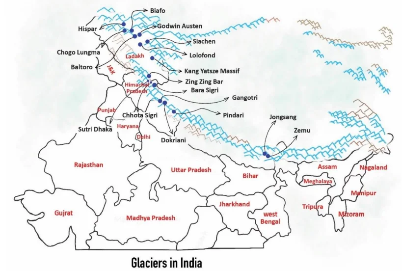
Major Glaciers in the Himalayas
The Himalayas act like a giant water tank for Asia. They contain thousands of Glaciers (slow-moving rivers of ice). These glaciers melt slowly to feed our biggest rivers like the Ganga, Indus, and Yamuna, ensuring water flows even in hot summers.
1. What is a Glacier?
Imagine a river, but instead of liquid water, it is made of solid ice. It moves very slowly (a few centimeters a day) down the mountain slope. This is a Glacier.
Why are they important? They store fresh water in the form of ice. When they melt, they become the source of rivers.
2. Where are the biggest glaciers?
Most of the giant glaciers are found in the Karakoram Range (part of the Trans-Himalayas). This area is often called the 'Third Pole' of the Earth because it has so much ice outside the North and South Poles.
3. Important Glaciers by Region
A. The Giants of Karakoram (Ladakh & J&K)
This region has the highest concentration of glaciers.
1. Siachen Glacier:
- Fame: The largest glacier in India (outside polar regions). Length: ~76 km.
- Strategic: It is the highest battlefield in the world where Indian troops are stationed.
- River: Melting ice from here creates the Nubra River.
2. Baltoro & Biafo: Massive glaciers located in the Gilgit-Baltistan region.
3. Hispar: Another major glacier in the Karakoram system.
B. Glaciers of Uttarakhand (The Holy Sources)
These are culturally very significant because they give birth to holy rivers.
1. Gangotri Glacier: The source of the River Ganga (Bhagirathi). It is located in the Uttarkashi district.
2. Yamunotri Glacier: The source of the River Yamuna.
3. Pindari Glacier: A beautiful glacier popular with trekkers. It feeds the Pindar river.
4. Milam Glacier: The source of the Gori Ganga river.
C. Glaciers of Sikkim (Eastern Himalayas)
1. Zemu Glacier:
- Significance: The largest glacier in the Eastern Himalayas.
- Location: It is located at the base of Kanchenjunga (India's highest peak).
- River Source: It feeds the Teesta River.
D. Glaciers of Himachal Pradesh
1. Bara Sigri: The largest glacier in Himachal Pradesh (located in Lahaul-Spiti). It feeds the Chenab river.
2. Sonapani: A well-known glacier visible from the Rohtang Pass.
| Glacier | State/Region | Range |
|---|---|---|
| Biafo | Jammu & Kashmir | Karakoram |
| Hispar | Jammu & Kashmir | Karakoram |
| Chogo Lungma | Gilgit Baltistan | Karakoram |
| Baltoro | Gilgit Baltistan | Karakoram |
| Godwin Austen | Jammu & Kashmir | Karakoram |
| Siachen | Jammu & Kashmir | Karakoram |
| Lolofond | Jammu & Kashmir | Karakoram |
| Kang Yatsze massif | Ladakh (Markha Valley) | Trans-Himalaya |
| Zing Zing Bar | Himachal Pradesh | Himalaya |
| Bara Sigri | Himachal Pradesh | Himalaya |
| Sutri Dhaka | Himachal Pradesh | Himalaya |
| Chhota Sigri | Himachal Pradesh | Himalaya |
| Gangotri | Uttarakhand | Himalaya |
| Pindari | Uttarakhand | Himalaya |
| Jongsong | Sikkim | Himalaya |
| Zemu | Sikkim | Himalaya |
Prelims tips
- Siachen → largest glacier in India, Karakoram.
- Bara Sigri → largest in Himachal Pradesh.
- Gangotri → source of Ganga (Uttarakhand).
- Zemu → largest glacier in Eastern Himalayas (Sikkim).
- Karakoram has maximum glacier concentration.
- Bara Shigri (Lahaul–Spiti) is the largest glacier of Himachal Pradesh and feeds the Chandra river (Chenab system).
Mains points
- The Himalayas house large glaciers, especially in Karakoram (Siachen, Baltoro).
- These glaciers feed perennial rivers like Ganga, Yamuna, Indus.
- Zemu glacier in Sikkim highlights eastward extension of Himalayan glaciation.
- Glaciers are important for water security, agriculture, and hydropower.
- Strategically, Siachen is crucial for India’s defense in Ladakh.
Northern Plains of India
The Northern Plains are the youngest part of India's geography. Imagine a massive, flat playground formed by mud and sand brought down by three giant river systems (Indus, Ganga, Brahmaputra). Although it covers only a small part of India's land, it feeds the whole country and houses 40% of the population.
1. How were these Plains formed? (The Story)
Millions of years ago, when the Himalayas were rising, a huge ditch (depression) was formed at their feet (South of Himalayas).
The Filling Process:
- Rivers flowing down from the new Himalayas brought huge amounts of sand, silt, and clay (called Alluvium).
- Over millions of years, these rivers dumped this soil into the ditch, filling it up completely.
- Result: The deep ditch became a flat, fertile land which we now call the Northern Plains.
2. Location & Size
Location: They are sandwiched between the Himalayas in the North and the Peninsular Plateau in the South.
Length: They stretch about 3200 km from West (Punjab) to East (Assam).
Width: They are not the same width everywhere.
- Widest: In the West (Punjab/Rajasthan) ~300 km.
- Narrowest: In the East (Assam) ~150 km.
Depth of Soil: The layer of mud/soil is incredibly deep. In some places near the Himalayas, the soil is 8000 meters deep (almost as high as Mt. Everest is tall)!
3. Which Rivers made this?
Three major river families created these plains:
1. The Indus System: Formed the Western part (Punjab/Pakistan plains).
2. The Ganga System: Formed the Central part (UP, Bihar, Bengal).
3. The Brahmaputra System: Formed the Eastern part (Assam Valley).
4. Why is it called 'Monotonous'?
Geographers call this land 'Monotonous' because it is extremely flat. There are no hills or mountains for hundreds of kilometers. The only variation you see are river banks (levees) and flood plains.
| Feature | Description | Significance |
|---|---|---|
| Formation | River deposits filling a deep depression. | Created the world's most fertile agricultural land. |
| Soil Type | Alluvial Soil (Loamy and rich). | Perfect for Wheat, Rice, and Sugarcane. |
| Population | Highest density in India. | Easy to build houses, roads, and railways due to flat land. |
| Depth | Varies from 1300m to 8000m. | Huge groundwater reserves are stored here. |
| Aspect | Details |
|---|---|
| Location | South of Shiwaliks, north of Peninsular India |
| Rivers | Indus, Ganga, Brahmaputra systems |
| Extent | 3200 km (east-west) |
| Width | 150–300 km (widest in west) |
| Alluvial Depth | 1300–1400 m (south), >8000 m near Shiwaliks |
| Topography | Monotonous, river levees, micro undulations |
Prelims tips
- Northern Plains = world’s largest alluvial tract (~3200 km long).
- Width: 150–300 km; increases westward.
- Depth of alluvium: 1300 m (south) → 8000 m (Shiwaliks).
- Formed by Indus, Ganga, Brahmaputra river systems.
Mains points
- The Northern Plains are young depositional landforms formed by Himalayan and Peninsular river sediments.
- They support dense population due to fertile soils, water availability, and flat terrain.
- Physiographically monotonous but agriculturally rich, forming the ‘food bowl of India’.
- Vary in width, depth, and micro-topography (levees, floodplains).
Physiographic Divisions of Northern Plains
As rivers flow down from the Himalayas, they deposit soil in four distinct strips or belts. From North to South, these are: Bhabar (Rocky/Porous), Tarai (Wet/Swampy), Bhangar (Old Soil/High Ground), and Khadar (New Soil/Low Ground).
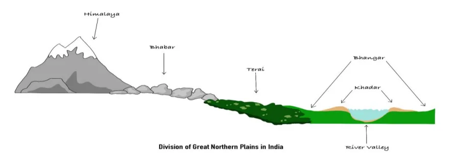
1. The North-to-South Journey
Imagine you are walking from the top of the Himalayas down to the plains. You will cross four different types of land in a specific order.
2. Bhabar (The Porous Rock Bed)
Location: This is the first belt lying immediately at the foot of the Himalayas (Shiwaliks).
What is it? It is a narrow belt (8-10 km wide) of heavy rocks and pebbles that rivers dump as soon as they leave the steep mountains.
Key Feature (The Magic Trick): Because it is made of loose rocks, it is very porous (like a sieve). Small rivers and streams disappear underground here. You can hear the water flowing underneath, but the surface looks dry!
Agriculture: Not suitable for crops because water sinks down. Only big trees with long roots grow here.
3. Tarai (The Wet Swamp)
Location: South of the Bhabar belt.
What is it? The water that disappeared in Bhabar re-emerges (comes back to the surface) here.
Key Feature: Because the water comes back up without a proper channel, this area becomes wet, swampy, and marshy.
Ecology: Historically, this was a thick forest filled with mosquitoes and wildlife. Now, much of it has been cleared for farming (Sugarcane/Rice), especially in UP and Punjab.
4. Bhangar (The Old Alluvium)
Location: This forms the largest part of the Northern Plains.
What is it? This is Older Soil deposited by rivers ages ago. It lies above the current flood level of rivers (High Ground).
Key Feature:
- It is like a terrace or a platform that floods usually don't reach.
- It contains calcium deposits (calcareous nodules) locally called 'Kankar'.
Agriculture: It is fertile but not as fertile as Khadar.
5. Khadar (The New Alluvium)
Location: The lowest land right next to the river banks.
What is it? This is New Soil deposited by floods almost every year.
Key Feature:
- It is the most fertile land because the soil is renewed annually.
- It creates the 'Floodplains'.
Agriculture: Best for intensive agriculture (growing crops year after year).
| Division | Features |
|---|---|
| Bhabar | 8–10 km belt of coarse sediments; porous; rivers disappear; dry beds; unsuitable for farming |
| Tarai | South of Bhabar; swampy; marshy; re-emerging streams; fertile but unhealthy |
| Bhangar | Old alluvium; terraces; dark, clayey, humus-rich; has kankar; found in doabs |
| Khadar | New alluvium; floodplains; sandy, porous, fertile; renewed annually |
Prelims tips
- Bhabar → porous belt, rivers disappear underground.
- Tarai → swampy belt south of Bhabar; re-emergence of rivers.
- Bhangar → old alluvium, terraces, kankar nodules.
- Khadar → new alluvium, fertile, floodplains (renewed annually).
- Punjab’s Khadar floodplains = ‘Bets’.
- Saline patches in Bhangar = Reh/Kallar/Bhur.
Mains points
- The Northern Plains show distinct physiographic zones: Bhabar (porous belt), Tarai (marshy belt), Bhangar (old alluvium), Khadar (new alluvium).
- Bhabar and Tarai represent drainage features; Bhangar and Khadar represent depositional features.
- Khadar is agriculturally most important due to annual renewal of fertile soil.
- Bhangar has local variations like Barind (Bengal), Bhur (Doab), and saline patches (Reh/Kallar).
Regional Division of Northern Plains – Punjab Plains
The Punjab Plains are the westernmost part of India's Northern Plains. The name 'Punjab' comes from Persian: 'Panj' (Five) + 'Aab' (Water). This fertile region is built by the Indus River and its five tributaries. While a large part lies in Pakistan, the Indian section is the heart of our agriculture.
1. Location and Boundaries (Where is it?)
Region: It primarily covers the states of Punjab, Haryana, and Delhi.
The Great Water Divide: Imagine a raised barrier separating two swimming pools. The Delhi-Aravalli Ridge acts as this barrier.
- Rivers to its West (like Sutlej) flow into the Arabian Sea.
- Rivers to its East (like Yamuna) flow into the Bay of Bengal.
2. Formation (How was it made?)
This land was created by the soil deposited by the Indus River System.
The 5 Rivers: Jhelum, Chenab, Ravi, Beas, and Sutlej.
Indian Context: The major portion of the Indus basin lies in Pakistan. In India, the plains are mostly formed by the Ravi, Beas, and Sutlej rivers.
3. The Concept of 'Doabs' (Land Between Rivers)
The most unique feature of this region is the presence of 'Doabs'.
Definition: 'Do' = Two, 'Aab' = Water. So, a Doab is the fertile land located between two rivers.
Why is it important? Since it is sandwiched between rivers, the soil here is extremely fertile and water is easily available for farming.
Example: The Bist-Jalandhar Doab lies between the Beas and Sutlej rivers.
4. Local Geographical Terms (The Landscape)
The landscape here is not just flat; it has specific features with local names:
A. Bets (The Floodplains):
- These are low-lying areas right next to the river channel.
- They get flooded during monsoons, receiving new, fertile soil (similar to 'Khadar').
B. Dhayas (The Bluffs):
- These are the steep walls or high banks that separate the low 'Bet' land from the higher upland.
C. Chhos (The Destructive Streams):
- In the northern foothills (Shiwaliks), heavy rains create fast-flowing seasonal streams.
- These streams, called Chhos, cut deep gullies into the land, causing massive soil erosion. This is a major problem in districts like Hoshiarpur.
5. Sub-Divisions of the Plains
A. Malwa Plains: The rolling plains located to the South of the Sutlej river.
B. Haryana Tract: The area between the Ghaggar and Yamuna rivers. It acts as the bridge between the Indus and Ganga river systems.
C. Rajasthan Bagar: The semi-arid transition zone in the south-west near the Rajasthan border, marked by sand dunes.
6. The Mystery of the Ghaggar River
The River: The Ghaggar is an inland river (it dries up in the sand instead of reaching the sea).
Significance: Geologists believe it is the remnant of the mighty ancient Saraswati River mentioned in Vedic texts.
| Aspect | Details |
|---|---|
| Location | Western part of Northern Plains; Delhi-Aravalli ridge separates from Ganga Plains |
| Rivers | Indus, Jhelum, Chenab, Ravi, Beas, Sutlej |
| Divisions | Doabs (interfluvial tracts) |
| Floodplains | Bets (Khadar floodplains, locally ‘Dhayas’) |
| Erosion Features | Chhos (seasonal streams from Shiwalik erosion) |
| South-west Part | Marked by shifting sand dunes |
| Special Areas | Malwa Plain (Sutlej south), Haryana Tract (Ghaggar–Yamuna divide) |
| Ghaggar River | Considered present-day successor of Saraswati |
Prelims tips
- Punjab Plains → formed by Indus and tributaries.
- Divided into doabs; fertile floodplains called Bets/Dhayas.
- Ghaggar = considered successor of Saraswati River.
- South-west Punjab Plains = shifting sand dunes.
- Chhos = seasonal torrents due to Shiwalik erosion.
Mains points
- Punjab Plains represent western extension of Northern Plains formed by Indus system.
- Doabs and fertile floodplains (Bets/Dhayas) make it agriculturally rich.
- Erosion in Shiwaliks creates Chhos; SW part has sand dunes.
- Haryana Tract is important as Yamuna–Sutlej divide; Ghaggar River linked to ancient Saraswati.
Regional Divisions of Northern Plains (West to East Journey)
The Northern Plains are huge, so we divide them into regions based on the rivers that flow through them. From West to East, we travel from the Dry Desert (Rajasthan) to the Fertile Farmlands (Ganga) and finally to the Green Valley (Brahmaputra) .
1. Rajasthan Plains (The Great Indian Desert)
Location: Located to the West of the Aravalli Mountains.
Formation: Millions of years ago, this area was under the sea! That is why we still find saline (salty) lakes here.
Two Main Parts:
- A. Marusthali (The Dead Land): The western part which is a proper desert with shifting sand dunes (called 'Dhrians'). It is very dry.
- B. Rajasthan Bagar (Semi-Dry): The eastern part near the Aravallis. It gets a little rain and supports some agriculture. The fertile patches here are called 'Rohi'.
Key Feature (Inland Drainage): Most rivers here (like the Luni) do not have enough water to reach the ocean. They get lost in the sand or flow into salt lakes. This is called 'Inland Drainage'.
Salt Lakes: Famous lakes like Sambhar (largest inland salt lake), Didwana, and Kuchaman are found here.
2. The Ganga Plains (The Heart of India)
Location: This is the central and largest part, stretching from the Yamuna River (Delhi/UP) to the Bangladesh border (Bengal).
Why is it special? It is the most fertile land in India, fed by Himalayan rivers. It is divided into three sections:
- Upper Ganga Plain: Western UP (Rohilkhand).
- Middle Ganga Plain: Eastern UP and Bihar (Magadh/Awadh).
- Lower Ganga Plain: West Bengal (Sundarbans).
Key Feature (Meandering Rivers): Since the land is very flat, rivers flow slowly and curve like a snake (Meandering). This causes frequent floods, especially by the Kosi River (called the 'Sorrow of Bihar').
3. The Brahmaputra Plains (The Assam Valley)
Location: It is a long, narrow valley in Assam, surrounded by mountains on all sides (except the West).
The River Layout: The mighty Brahmaputra river flows right through the middle.
Key Feature (River Islands): The Brahmaputra carries so much sand and mud that it blocks its own path, creating islands inside the river. Majuli is the largest inhabited river island in the world.
Biodiversity: Unlike the dry Rajasthan plains, this area is wet, humid, and full of thick forests and wildlife (like Rhinos in Kaziranga).
| Region | Climate | Main Feature | Famous For |
|---|---|---|---|
| Rajasthan Plain | Arid (Dry & Hot) | Sand Dunes & Salt Lakes | Thar Desert, Sambhar Lake, Inland Drainage. |
| Ganga Plain | Moderate to Humid | Fertile Alluvial Soil | Agriculture (Wheat/Rice), High Population Density. |
| Brahmaputra Plain | Humid (Heavy Rain) | River Islands & Floods | Majuli Island, Tea Gardens, Kaziranga National Park. |
Prelims tips
- Rohi: These are fertile tracts of land found in the Rajasthan Bagar region.
- Dhrians: These are shifting sand dunes found in the Thar desert.
- Majuli: It is the world's largest river island, located in the Brahmaputra River (Assam).
- Sunderbans: Located in the Lower Ganga Plain, it is the world's largest delta and home to Mangroves.
Mains points
- Agriculture vs Geography: Explain how the geography changes the crops: Millet/Bajra in dry Rajasthan -> Wheat/Sugarcane in UP -> Rice/Jute in wet Bengal/Assam.
- Flood Management: Contrast the flood problems: The Kosi floods due to course-shifting in Bihar, while the Brahmaputra floods due to heavy rainfall and narrow valley constraints in Assam.
- Desertification: Discuss how the Thar desert is trying to expand eastwards and how the 'Great Green Wall' of India (planting trees) aims to stop it.
Significance of the Northern Plains (Why do they matter?)
The Northern Plains are the backbone of India. Even though they cover only a small part of the land, they hold 40% of India's population. Because the land is flat and the soil is perfect, this region is the 'Food Factory' (Granary) of the country and the easiest place to build cities and railways.
1. Agriculture: The Granary of India
This region is called the 'Granary' because it produces surplus food (Wheat and Rice) for the whole nation.
Why is it so fertile?
- Soil: The rivers bring fresh, soft mud (Alluvium) every year which acts like natural fertilizer.
- Water: The rivers here are Perennial (they flow 365 days a year because they come from melting Himalayan snow), making irrigation easy.
- Flatness: Since the land is flat, it is easy to use tractors and machines.
2. High Population Density (Home to Millions)
If you look at a population map of India, this region is the darkest red.
Why do so many people live here?
- Easy Life: Unlike the mountains where building a house is hard, flat land allows for cheap and easy construction of houses and roads.
- Climate: While summers are hot, the climate is generally suitable for human settlement compared to the freezing Himalayas or arid deserts.
- Jobs: Agriculture and industries provide employment.
3. Infrastructure (Roads & Rails)
The Web of Transport: The Northern Plains have the densest network of Railways and Roadways in India.
Why? It is very cheap to lay train tracks or build highways on flat soft ground compared to blasting tunnels through mountains or building bridges over the undulating plateau.
4. Cultural & Religious Significance
The Spiritual Heart: This region is the birthplace of Indian civilization (Indus Valley to Vedic Age).
Holy Rivers: The Ganga and Yamuna are worshipped as goddesses.
Pilgrimage: Cities like Varanasi (Kashi), Haridwar, Mathura, and Prayagraj (Sangam) are located here. Millions gather here for the Kumbh Mela.
5. Economic & Industrial Value
Agro-based Industries: Factories that use farm products (like Sugar mills in UP, Cotton textiles, and Jute mills in Bengal) flourish here.
Navigation: Rivers like the Ganga are wide and deep, allowing big boats to carry cargo. National Waterway 1 (from Haldia to Prayagraj) runs through here.
| Significance | Reason | Example |
|---|---|---|
| Food Security | Fertile Soil + Water | Production of Wheat (Punjab) & Rice (Bengal). |
| Settlement | Flat Land makes building easy | 40% of India lives here (UP, Bihar, Bengal). |
| Transport | No mountains to cross | Densest Railway Network in India. |
| Culture | Sacred Rivers | Varanasi (Oldest living city), Kumbh Mela. |
Prelims tips
- Granary: The term 'Granary of India' refers specifically to these plains (especially Punjab/Haryana).
- Waterway: National Waterway 1 (NW-1) is the longest waterway in India, flowing through these plains on the Ganga river.
- Population: Uttar Pradesh (located in these plains) is the most populous state in India.
- Urbanization: Major metro cities like Delhi and Kolkata are located on the banks of rivers in this plain.
Mains points
- Food Security Role: Explain how the Green Revolution in the Northern Plains (Punjab/Haryana) saved India from famine in the 1960s.
- Pollution Crisis: Discuss the negative side—high population density and industries have made the Ganga and Yamuna the most polluted rivers.
- Groundwater Depletion: Since farming is intensive here, groundwater is being pumped out faster than rain can refill it, leading to a water crisis.
The Great Indian Desert (Thar Desert)
The Thar Desert is a unique landscape in North-West India and the world's 9th largest desert. Although it looks like a flat plain, geologically, it is actually an extension of the Peninsular Plateau that has been covered by sand over millions of years.
1. Location and Origin (Where & Why?)
Location: It lies mostly in Western Rajasthan, extending into Gujarat, Punjab, and Haryana. To its East lie the Aravalli Mountains.
Why is it a desert?
The Aravalli hills run parallel to the rain-bearing monsoon winds. Imagine a wall standing sideways; it doesn't block anything. Similarly, the Aravallis don't block the winds, so the clouds pass by without dropping rain, leaving this area dry.
Geological Surprise: Millions of years ago (Mesozoic era), this entire desert was under the sea. We know this because scientists have found marine fossils and wood fossils (in Aakal Wood Fossil Park) here.
2. Two Main Zones of the Desert
The desert is broadly divided into two parts based on how dry they are:
A. Marusthali (The Dead Land)
What is it? This is the 'real', harsh desert in the West.
Features:
- It has very little vegetation (cactus, thorny bushes).
- It is covered with shifting sand dunes.
- Barchans: These are crescent-shaped (moon-shaped) sand dunes that move with the wind. They are a common sight here.
B. Rajasthan Bagar (The Semi-Desert)
What is it? This is the transition zone between the dry desert in the West and the green Aravalli mountains in the East.
Features:
- It is not completely dry. It has a thin layer of sand but supports some grass and farming.
- It serves as a buffer zone protecting the rest of India from the desert sands.
3. Water Features (Rivers & Lakes)
A. The Luni River (The Lifeline):
- This is the only major river in this region.
- Source: It starts from the Pushkar Valley (Aravallis).
- End: It does not reach the sea. It disappears into the marshy lands of the Rann of Kutch (Gujarat).
B. Inland Drainage:
- Most small streams here flow for a short distance and then get lost in the sand or drain into salt lakes. They never reach the ocean. This process is called 'Inland Drainage'.
C. Salt Lakes (Playas):
- The region has many saltwater lakes like Sambhar (India's largest inland salt lake), Didwana, and Kuchaman.
- Why Salty? Because the water evaporates quickly due to extreme heat, leaving salt deposits behind.
4. Important Local Terms
- Rohi: The fertile green patches of land found along the river banks in the desert. These are good for agriculture.
- Thali: The sandy plain area located to the North of the Luni river.
- Dhand: Alkaline (salty) lakes found in the depressions (low points) between sand dunes.
- Dhrians: The local name for shifting sand dunes that move with the wind.
| Aspect | Details |
|---|---|
| Extent | NW Aravallis to Cholistan Desert (Pakistan) |
| Local Name | Marusthali (‘Dead Land’) |
| Semi-desert Region | Bagar (thin sand cover, seasonal streams, salt lakes) |
| Fertile Patches | Rohi (cultivable spots) |
| River | Luni – seasonal, from Pushkar valley |
| Inland Drainage | Streams → playas/lakes (Sambhar, Didwana, etc.) |
| Landforms | Sand dunes, barchans, mushroom rocks, oases |
| Geology | Once under sea; uplift during Pleistocene |
Prelims tips
- Thar = world’s 9th largest desert; locally called Marusthali.
- Bagar = semi-desert west of Aravallis; drained by Luni; has salt lakes.
- Rohi = fertile patches in Thar.
- Luni = seasonal river; flows into Rann of Kutch.
- Sambhar Lake = largest inland salt lake in India.
- Desert once submerged under sea (Permo-Carboniferous).
Mains points
- The Thar Desert represents an arid landscape shaped by aridity, shifting dunes, saline lakes, and seasonal streams.
- It plays a role in salt production (Sambhar, Didwana) and sustains pockets of agriculture in Rohi and Bagar regions.
- River Luni is the most significant seasonal stream, highlighting desert hydrology.
- Geological history shows the Thar was once a seabed, uplifted during the Pleistocene, making it a unique physiographic unit.
The Peninsular Plateau of India (The Ancient Tableland)
The Peninsular Plateau is the oldest and most stable part of India. Imagine a huge, triangular-shaped table made of hard rocks. It was formed when the ancient Gondwana land broke apart millions of years ago. It is rich in minerals like Coal and Iron, making it the industrial heart of India.
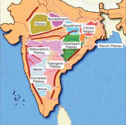
1. What is a 'Plateau'?
A plateau is a flat-topped highland, like a table standing above the surrounding area.
The Indian Context: The Peninsular Plateau rises 600-900 meters above sea level and covers the southern part of India.
2. Location and Extent (Where is it?)
Shape: It is roughly triangular, with the base in the North and the tip in the South (Kanyakumari).
Boundaries:
- North: Delhi-Aravalli Ridge and Rajmahal Hills.
- West: Gir Range (Gujarat) and Western Ghats.
- East: Eastern Ghats.
- South: Cardamom Hills.
Surprise Extension: Even the Shillong Plateau (Meghalaya) in the North-East is actually a broken piece of this same Peninsular Plateau!
3. How was it formed? (The History)
Origin: It was once part of the supercontinent Gondwanaland. When India split and moved northwards, this block remained solid and stable.
Composition: It is made of very old, hard crystalline rocks (Igneous and Metamorphic) like Granite and Gneiss. This makes it stable and earthquake-resistant (mostly).
4. Unique Features of the Plateau
A. Rift Valleys (Cracks in the Earth):
- While most rivers flow East, the Narmada and Tapti rivers flow West. Why?
- Because they flow through deep cracks in the earth called 'Rift Valleys' created during the Himalayan uplift.
B. Ravines (Badlands):
- In the Chambal valley (MP/Rajasthan), the river has cut deep, maze-like gullies into the land. These are called Ravines (famous hideouts for dacoits in movies!).
C. The Garo-Rajmahal Gap:
- A long time ago, a fault (crack) separated the Meghalaya Plateau from the main Indian Plateau. This gap was later filled with mud by the Ganga and Brahmaputra rivers. Today, it separates West Bengal from Meghalaya.
5. Why is it economically important?
This region is the Storehouse of Minerals.
- 98% of India's Coal is found here (Gondwana coal).
- It is rich in Iron ore, Manganese, Bauxite, Copper, and Gold.
- Most of India's heavy industries (Steel plants, Power plants) are located here.
| Feature | Description | Significance |
|---|---|---|
| Age | Oldest part of India. | Very stable landmass. |
| Shape | Inverted Triangle. | Determines India's coastline. |
| Rocks | Igneous & Metamorphic. | Rich in metallic minerals. |
| Rivers | Narmada, Tapti, Godavari. | Irrigation & Hydropower. |
| Extensions | Shillong Plateau (NE India). | Tea cultivation & coal. |
Prelims tips
- The Gap: The 'Malda Gap' or 'Garo-Rajmahal Gap' separates the main plateau from the Meghalaya plateau.
- West Flowing: Narmada and Tapti are the only major peninsular rivers flowing West because of Rift Valleys.
- Tors: These are mushroom-shaped granite rocks found on the plateau due to weathering.
- Minerals: Gondwana rocks = Coal. Dharwar rocks = Metals (Iron/Gold).
Mains points
- Industrial Backbone: Explain how the Chotanagpur Plateau (part of this region) became the hub of India's steel and heavy industries due to iron and coal proximity.
- Water Crisis: Unlike Himalayan rivers, Peninsular rivers are rain-fed (seasonal). Discuss the water scarcity issues in states like Maharashtra and Karnataka.
- Agriculture: The black soil (Deccan Trap) found here is perfect for Cotton cultivation.
Plateaus of Peninsular India
The Peninsular Plateau is divided into the Central Highlands, the Deccan Plateau, and the North-Eastern Plateau. Each region has unique physiography, elevation, geology, and resource distribution, making it the mineral and agricultural heart of India.
1. The Central Highlands (The Northern Part)
Location: Lies North of the Narmada River and South of the Great Northern Plains. This region forms the older part of the Peninsular Block.
Geology: Composed mainly of ancient igneous and metamorphic rocks (Granite & Gneiss) belonging to the Archean age.
Slope: General slope is from South-West to North-East, which guides river flow patterns. Hence, rivers like Chambal, Betwa, and Ken flow towards the Yamuna.
Climate: Semi-arid to sub-humid climate; rainfall decreases westwards.
Economic Use: Known for livestock rearing, millet farming, and mining (limestone, sandstone).
Sub-Divisions:
A. Marwar Upland (Rajasthan):
- Location: Lies to the East of the Aravalli Range.
- Formation: Formed by river erosion and deposition of the Luni and Banas river systems.
- Soil: Sandy-loam soil with low fertility.
- Significance: Acts as a transitional zone between the Thar Desert and the Peninsular Highlands.
B. Malwa Plateau (Madhya Pradesh):
- Formation: Built by extensive volcanic eruptions → Basaltic deposits.
- Soil: Black cotton soil (Regur) ideal for Cotton, Soybean, and Pulses.
- Drainage: Drained by the Chambal, Kali Sindh, and Mahi rivers.
- Economic Importance: Important for agriculture and urban centres like Indore, Ujjain.
C. Bundelkhand Plateau (UP & MP):
- Characteristics: Rugged, rocky terrain made of ancient granite and gneiss.
- Relief: Deep ravines (badlands) formed due to gully erosion by Chambal & Ken rivers.
- Challenges: Drought-prone region due to poor soil moisture and low rainfall.
- Economy: Known for pulses, oilseeds, and emerging as a region for Bundelkhand Expressway.
D. Chhotanagpur Plateau (The Mineral Heart):
- Location: Spread across Jharkhand, Chhattisgarh, Odisha, and West Bengal.
- Geology: Rich in Gondwana coal deposits and metallic minerals.
- Mineral Wealth: Coal, Iron ore, Bauxite, Manganese, Uranium – hence called the 'Ruhr of India'.
- Industrial Importance: Hosts major industries: Jamshedpur (Steel), Bokaro (Steel), Dhanbad (Coal).
- Patlands: Table-like flat uplands formed by long-term erosion.
2. The Deccan Plateau (The Southern Triangle)
Location: Triangular landmass South of the Narmada River.
Geological Formation: Result of massive volcanic eruptions during the Cretaceous period.
Deccan Trap: Staircase-like structure formed by layered lava flows; covers Maharashtra, parts of MP and Gujarat.
Soils: Dominated by Black (Regur) soil, ideal for cotton.
Drainage: Rivers flow Eastwards (Godavari, Krishna, Kaveri) due to slope towards the Bay of Bengal.
Sub-Divisions:
A. Maharashtra Plateau:
- Entirely made of Basalt rocks of the Deccan Traps.
- Agriculture: Cotton, Sugarcane, Soybean.
- Drainage: Godavari and Krishna tributaries pass through.
B. Karnataka Plateau (Mysore Plateau):
- Malnad: Western, hilly region with dense forests and heavy rainfall.
- Maidan: Eastern, undulating plains suitable for cultivation.
- Rivers: Kaveri, Tungabhadra, and Sharavati originate here.
- Shravana Belgola, Mysuru – significant cultural sites.
C. Telangana Plateau:
- One of the oldest parts of the Indian landmass (Archean Gneiss).
- Agriculture: Groundnut, Millets, Cotton.
- Drainage: Godavari, Krishna, Manjira rivers.
- Minerals: Rich in coal (Singareni), limestone, granite.
3. The North-Eastern Plateau (The Separated Sibling)
Geological Fact: Once part of the Peninsular Plateau but separated due to faulting.
Garo-Rajmahal Gap: A major tectonic fault filled by alluvial deposits of Ganga & Brahmaputra.
Rock Type: Granite and Gneiss, similar to the Peninsular region.
Climate: One of the wettest regions on Earth.
Important Peaks: Shillong Peak (highest in Meghalaya).
Key Features:
- Comprises Garo, Khasi, and Jaintia hills.
- Famous sites: Cherrapunji, Mawsynram (world’s highest rainfall).
- Contains important passes and river gorges.
- Known for Pineapple, Lakadong Turmeric, Oranges, and Limestone deposits.
| Plateau | Location / Features |
|---|---|
| Central Highlands | North of Narmada; Marwar, Malwa, Bundelkhand, Chhotanagpur |
| Marwar Upland | East of Aravallis; 250–500 m; rolling plains; Chambal & Banas erosion |
| Malwa Plateau | MP; basaltic lava, black soil; cotton cultivation |
| Bundelkhand Plateau | UP–MP; dissected upland; granite & sandstone; semi-arid |
| Chhotanagpur Plateau | Jharkhand–Chhattisgarh–WB; mineral rich; Patland (‘Ruhr of India’) |
| Deccan Plateau | South of Narmada; volcanic trap structure; Maharashtra, Karnataka, Telangana sub-plateaus |
| Maharashtra Plateau | Basaltic lava; regur soil; Godavari & Krishna valleys |
| Karnataka Plateau | Mysore Plateau; Malnad (hilly) & Maidan (plain) |
| Telangana Plateau | Archaean gneiss; peneplains + ghats; drained by Godavari, Krishna, Penneru |
| North-Eastern Plateau | Meghalaya/Shillong; Garo, Khasi, Jaintia, Mikir hills; heavy rainfall, eroded |
Prelims tips
- Central Highlands: north of Narmada; includes Malwa, Bundelkhand, Chhotanagpur.
- Marwar Upland = east of Aravallis, rolling plain.
- Malwa = basaltic lava, black soil (cotton).
- Chhotanagpur = mineral-rich, Patland = ‘Ruhr of India’.
- Deccan Plateau = volcanic trap, black cotton soil, rivers west→east.
- Karnataka Plateau = Malnad (hilly, forests) + Maidan (plain).
- NE Plateau = Shillong Peak highest; heavy rainfall, erosion.
Mains points
- The Peninsular Plateaus show diversity: Central Highlands (erosional, old rocks), Deccan Plateau (volcanic), NE Plateau (rainfall-eroded).
- Chhotanagpur Plateau’s mineral wealth sustains India’s mining industry.
- Deccan Plateau’s black soils & rivers enable cotton agriculture & hydropower.
- NE Plateau (Meghalaya) receives highest rainfall, leading to erosion & unique ecology.
- The physiography influences agriculture, resource distribution, settlement patterns & industrialization.
Hill Ranges of the Peninsular Plateau
The hill ranges of Peninsular India are among the oldest mountains in the world. They are residual, denuded mountains with local significance, acting as watersheds, influencing rainfall, and serving as biodiversity hotspots.
1. Introduction to Peninsular Hills
The Peninsular Plateau is part of the ancient Gondwanaland. Its hills are mostly Relict (Residual) Mountains, meaning they are the 'leftovers' of huge mountain chains that existed millions of years ago but have been eroded by wind and water.
2. The Aravalli Range: The Oldest Barrier
Structure: These are the oldest fold mountains in the world. They stretch from Gujarat through Rajasthan to Delhi (where they end as the 'Delhi Ridge').
Climate Impact: They run parallel to the direction of the Arabian Sea branch of the Southwest Monsoon. Because they don't block these winds, the winds simply pass by without dropping rain, which is a major reason why the Thar Desert exists.
Economic Value: Often called a 'Museum of Minerals', they are rich in copper, zinc, and lead. The famous Makrana marble (used in the Taj Mahal) comes from here.
3. The Central Highlands: Vindhya & Satpura
These two ranges run parallel to each other from East to West, dividing North India from South India.
The Vindhyas: They act as a water divide. Rivers to their north (Chambal, Betwa) flow into the Ganga system, while rivers to their south flow into the Narmada.
The Satpuras: A classic example of a Block Mountain (Horst). They sit between two crack-valleys (Rift Valleys) occupied by the Narmada river in the north and the Tapti river in the south.
4. The Western Ghats (Sahyadri): The Great Escarpment
Formation: They are not true tectonic mountains but the steep, faulted edge (escarpment) of the Deccan Plateau formed when India broke away from Madagascar/Africa.
Topography: They form a continuous wall running parallel to the West Coast. Because they are continuous, they can only be crossed through specific gaps or passes (Ghats).
Rainfall: They force the moisture-laden monsoon winds to rise, cooling them down to cause very heavy rainfall on the windward side (coastal Karnataka/Maharashtra/Kerala).
5. The Eastern Ghats: The Broken Chain
Structure: Unlike the Western Ghats, these are highly discontinuous and eroded. They have been cut through by powerful rivers like the Godavari, Krishna, and Kaveri, which flow into the Bay of Bengal.
Composition: They are geologically very old (Pre-Cambrian) and are made of metamorphic rocks like Charnockites and Khondalites.
| Range | Extent | Elevation (m) | Highest Peak | Passes | Rivers/Drainage | Key Features |
|---|---|---|---|---|---|---|
| Aravali | Delhi to Gujarat–Rajasthan (~800 km, NE–SW) | 400–600 | Guru Shikhar (1722 m, Mount Abu) | Pipli, Dewair, Desuri | Small west-flowing seasonal rivers → Luni basin | Oldest fold mountains; once higher than Himalayas; locally ‘Jarga’ (Udaipur), ‘Delhi Ridge’. |
| Vindhyan | Parallel to Narmada–Son valley (1200 km, E–W) | 300–650 | Kalumar Peak (752 m) | — | North drains into Ganga; South into Narmada | Made of sedimentary rocks; plateau escarpments; cultural divide between North & South India. |
| Satpura | Between Narmada & Tapti (MP–MH border) | 600–900 | Dhupgarh (1350 m, Pachmarhi, Mahadeo Hills) | — | Narmada flows west, Tapti parallel south | ‘Sat+pura’ = seven folds; includes Mahadeo, Maikal ranges; forested; tiger reserves. |
| Western Ghats (Sahyadris) | Tapti Valley to Kanyakumari, parallel to west coast | 900–1600 | Anai Mudi (2695 m, Kerala) – highest in South India | Thal Ghat, Bhor Ghat, Palakkad Gap, Agumbe Ghat | West short swift rivers; East → Godavari, Krishna, Kaveri | Continuous escarpment; UNESCO biodiversity hotspot; heavy orographic rainfall; source of peninsular rivers. |
| Eastern Ghats | Mahanadi (Odisha) to Nilgiris (TN); discontinuous | 600 | Mahendragiri (1501 m, Odisha) | — | Drained by east-flowing rivers (Mahanadi, Godavari, Krishna) | Residual, broken hills; include Javadi, Shevaroy, Nallamala, Palkonda; less rainfall effect. |
Prelims tips
- Aravalis = oldest fold mountains; Guru Shikhar highest; Delhi Ridge is its extension.
- Vindhyas = Kalumar peak; escarpment plateau; cultural divide.
- Satpura = Dhupgarh highest (1350 m); Sat + Pura = seven folds.
- Western Ghats = Anai Mudi highest in South India; passes = Thal, Bhor, Palakkad.
- Eastern Ghats = discontinuous; Mahendragiri highest; include Shevaroy, Javadi, Nallamala.
Mains points
- Peninsular hill ranges represent the oldest landforms of India, deeply eroded but physiographically significant.
- Aravalis act as a climatic barrier between desert & fertile plains.
- Vindhya–Satpura ranges divide north Indian rivers from peninsular rivers.
- Western Ghats = biodiversity hotspot, source of rivers, orographic rainfall.
- Eastern Ghats = discontinuous, eroded, but ecologically important (mining, forests).
- Together, these ranges shape rainfall, agriculture, forest cover, settlement, and mineral distribution of peninsular India.
Mountain Peaks of Peninsular India
The Peninsular Plateau, though older and eroded compared to the Himalayas, has important peaks spread across Western Ghats, Eastern Ghats, Aravallis, Satpura, Nilgiris, Khasi, and Deccan ranges. These peaks are significant for geography, ecology, and culture.
| Peak | Range | State | Height (m) |
|---|---|---|---|
| Anamudi | Western Ghats | Kerala | 2695 |
| Doddabetta | Nilgiri Hills | Tamil Nadu | 2637 |
| Phawngpui (Blue Mountain) | Mizo Hills | Mizoram | 2157 |
| Shillong Peak | Khasi Hills | Meghalaya | 1965 |
| Mullayanagiri | Western Ghats | Karnataka | 1930 |
| Guru Shikhar | Aravalli Range | Rajasthan | 1722 |
| Arma Konda | Eastern Ghats | Andhra Pradesh | 1680 |
| Deomali | Eastern Ghats | Odisha | 1672 |
| Kalsubai | Western Ghats | Maharashtra | 1646 |
| Mahendragiri | Eastern Ghats | Odisha | 1501 |
| Dhupgarh | Satpura | Madhya Pradesh | 1350 |
| Bailadila Range | Bastar Hills | Chhattisgarh | 1276 |
| Malaygiri | Eastern Ghats | Odisha | 1187 |
| Sonsogor | Western Ghats | Goa | 1166 |
| Girnar | Junagadh Hills | Gujarat | 1069 |
| Doli Gutta | Deccan Plateau | Telangana–Chhattisgarh border | 965 |
| Amsot Peak | Shivalik Hills | Uttar Pradesh | 945 |
| Betalongchhip | Jampui Hills | Tripura | 930 |
| Someshwar Fort Peak | Someshwar Hills | Bihar | 880 |
Prelims tips
- Anamudi (2695 m) = Highest peak of South India (Kerala, Western Ghats).
- Doddabetta = Highest in Nilgiris (TN).
- Phawngpui = Mizoram’s highest (Blue Mountain).
- Shillong Peak = Meghalaya’s highest (1965 m).
- Mullayanagiri = Karnataka’s highest (1930 m).
- Guru Shikhar = Highest of Aravallis (Rajasthan, 1722 m).
- Deomali = Highest in Odisha (1672 m).
- Kalsubai = Highest in Maharashtra (1646 m).
- Girnar = Sacred peak in Gujarat (1069 m).
Mains points
- Peaks of Peninsular India are lower and older than Himalayas due to erosion, but are regionally significant.
- Anamudi and Nilgiris influence SW monsoon and biodiversity of Western Ghats.
- Aravalli’s Guru Shikhar shows remnants of ancient fold mountains.
- Chhotanagpur & Bailadila peaks are linked with mineral wealth and mining economy.
- Peaks like Kalsubai, Girnar, and Someshwar Fort have cultural-religious importance.
- These peaks play roles in hydrology, biodiversity, mineral distribution, and tourism.
Major Passes in Peninsular India
Passes in the Peninsular Plateau are important corridors through the Western Ghats and Aravallis, facilitating trade, transport, and historically battles. They also connect different cultural and ecological zones.
| Pass | Location/Range | State | Significance |
|---|---|---|---|
| Thal Ghat (Kasara Ghat) | Western Ghats, between Mumbai–Nashik | Maharashtra | Steepest railway line in India; major road & rail route to Mumbai |
| Bhor Ghat | Western Ghats, between Palasdari and Khandala | Maharashtra | Developed by Satavahanas; important trade route; connects Deccan with Konkan coast |
| Pal Ghat (Palakkad Gap) | Between Nilgiri Hills & Anamalai Hills, Western Ghats | Tamil Nadu–Kerala border | Low mountain gap facilitating trade & cultural exchange; link between Tamil Nadu & Kerala |
| Haldighati Pass | Aravalli Range, between Rajsamand & Pali districts | Rajasthan | Site of 1576 battle between Maharana Pratap and Man Singh (Mughal army); historical significance |
Prelims tips
- Thal Ghat = steepest railway line in India (Mumbai–Nashik route).
- Bhor Ghat = Satavahana route; connects Deccan → Konkan coast.
- Palakkad Gap = main corridor between Tamil Nadu & Kerala.
- Haldighati Pass = battle of 1576 between Maharana Pratap and Mughal army.
Mains points
- Passes in the Peninsular Plateau have historically facilitated trade and cultural interaction between coastal and inland regions.
- Palakkad Gap plays a key role in climate (allowing southwest monsoon winds to enter Tamil Nadu).
- Bhor and Thal Ghats remain critical for modern transport corridors connecting Mumbai with Deccan Plateau.
- Haldighati Pass showcases historical battles shaping Rajput–Mughal relations.
Significance of the Peninsular Plateau
Often called the 'Storehouse of Indian Minerals', the Peninsular Plateau is the economic backbone of the country. Geologically, it is the most stable landmass, and economically, it supports India's core industries (Steel, Power, Cement) and diverse agriculture.
1. The Mineral Heart of India (भारत का खनिज हृदय)
The plateau is rich in minerals because it is formed of ancient crystalline rocks.
- Chhotanagpur Plateau: Known as the 'Ruhr of India'. It holds the maximum concentration of Iron, Coal, Mica, and Manganese. This is why most steel plants (Bhilai, Bokaro, Rourkela) are located here.
- Dharwar Region (Karnataka): Famous for metallic minerals like Iron ore (Kudremukh) and Gold (Kolar).
- Gondwana Coal Fields: 98% of India's coal is found in the river valleys of the Damodar, Son, Mahanadi, and Godavari.
- Vindhyan System: Rich in Diamond (Panna) and Limestone (Cement industry).
2. Agriculture and Soil Diversity (कृषि और मृदा विविधता)
The plateau supports diverse cropping patterns due to varied soil types:
- Black Soil (Regur): Found in the Deccan Trap (Maharashtra/Gujarat). It retains moisture, making it perfect for Cotton and Sugarcane.
- Laterite Soil: Found on hilltops (Western/Eastern Ghats). Leached by heavy rain, it is excellent for Plantation Crops like Coffee, Tea, Rubber, and Cashew.
- Red Soil: Covers large parts of Telangana/Andhra. It is suitable for Millets, Pulses, and Oilseeds, providing nutritional security.
3. Hydropower Potential (जलविद्युत क्षमता)
Unlike Himalayan rivers, Peninsular rivers are better suited for dams because:
- Hard Rock Foundation: The rocky bed makes it safe to build large dams (e.g., Nagarjuna Sagar, Hirakud).
- Waterfalls: Steep slopes create natural waterfalls (e.g., Jog Falls, Sivasamudram), which are ideal for cheap hydroelectricity generation.
4. Forest and Biodiversity Wealth (वन और जैव विविधता)
The Western Ghats: One of the world's 8 'Hottest Hotspots' of biodiversity. It is home to medicinal plants, hardwoods (Teak, Sal, Sandalwood), and unique wildlife.
5. Strategic Industrial Location (रणनीतिक औद्योगिक अवस्थिति)
The availability of raw materials has led to industrial clusters:
- Steel/Heavy Industry: Located near coal/iron mines (Jamshedpur, Durgapur).
- Cotton Textiles: Concentrated in the cotton-growing Deccan region (Mumbai, Coimbatore).
- IT Industry: Cities like Bangalore and Hyderabad developed on the plateau due to the pleasant climate and stable geological ground.
| Region | Primary Significance | Key Resources/Crops |
|---|---|---|
| Chhotanagpur | Mineral Heartland (खनिज हृदयस्थल) | Iron Ore, Coal, Mica, Uranium |
| Deccan Trap | Agricultural Hub (कृषि केंद्र) | Black Soil, Cotton, Sugarcane |
| Malnad (Karnataka) | Plantation & Biodiversity (बागवानी और जैव विविधता) | Coffee, Arecanut, Sandalwood |
| Telangana Plateau | Rain-fed Agriculture (वर्षा आधारित कृषि) | Pulses, Oilseeds, Millets |
| High Ranges (Nilgiris) | Tourism & Tea (पर्यटन और चाय) | Tea Plantations, Ecotourism |
| Aspect | Importance |
|---|---|
| Minerals | Iron, manganese, coal, copper, bauxite, mica, gold, marble etc. |
| Soil | Black regur soil → excellent for cotton. |
| Agriculture | Cotton, maize, citrus fruits, tea, coffee, rubber, pulses. |
| Hydropower | Rivers and waterfalls (Jog, Shivanasamudra) → hydel power sites. |
| Tourism | Hill stations like Ooty, Mahabaleshwar; biodiversity hotspots. |
Prelims tips
- 'Ruhr of India': Refers to the Chhotanagpur Plateau due to its coal and iron richness (similar to the industrial Ruhr valley in Germany).
- Nuclear Minerals: The plateau contains Uranium (Jaduguda mines, Jharkhand) and Thorium (Monazite sands in Kerala coast).
- Geological Stability: Being an ancient shield, it rarely experiences major earthquakes (exceptions: Latur, Koyna due to fault lines).
- River Flow: Almost all major Peninsular rivers flow West-to-East because the plateau generally tilts towards the Bay of Bengal.
Mains points
- Industrial Location Theory: Explain why the Iron and Steel industry is concentrated in the peninsula (Raw material availability reduces transport cost, known as Weber's theory).
- Food Security: The plateau complements the Northern Plains. While the North provides Wheat/Rice, the South provides Pulses, Millets, and Oilseeds (Proteins and Fats).
- Energy Security: It provides the bulk of India's thermal energy (Coal from Gondwana) and Renewable energy (Hydro + Wind power in passes like Palakkad).
- Economic Value of Soil: The Black Soil (Regur) is crucial for the textile industry (Cotton) and sugar industry (Sugarcane).
Coastal Plains of India
The Coastal Plains are not just borders; they are the economic gateways of India. Geologically, the Western Coast is a 'Submerged Coast' (good for ports), while the Eastern Coast is an 'Emergent Coast' (good for deltas).
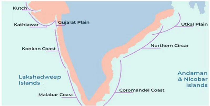
1. Introduction (परिचय)
Imagine India as a 'V' shape. The flat lands running along the edges of this 'V' (between the sea and the mountains) are the Coastal Plains. They stretch for about 7,516 km, covering 9 states and 4 Union Territories.
2. Western Coastal Plains (पश्चिमी तटीय मैदान)
Location: These are narrow strips of land sandwiched between the Western Ghats and the Arabian Sea.
Key Feature - Submerged Coast: This land has 'sunk' slightly into the sea. Because of this sinking, the sea water is very deep right next to the land. This makes it perfect for natural ports (like Mumbai) because big ships can come close to the shore without getting stuck.
Regional Divisions:
- Kutch & Kathiawar (Gujarat): The northernmost part. Includes the famous salt desert 'Rann of Kutch'.
- Konkan Coast (Maharashtra & Goa): A rocky and uneven coastline.
- Kannada Coast (Karnataka): Known for iron deposits and swift rivers.
- Malabar Coast (Kerala): The most famous part. It has 'Kayals' (Backwaters/Lagoons) which are lakes running parallel to the sea. The famous Nehru Trophy Boat Race happens here.
3. Eastern Coastal Plains (पूर्वी तटीय मैदान)
Location: These are wide strips of land between the Eastern Ghats and the Bay of Bengal.
Key Feature - Emergent Coast: Here, the land has either risen up or rivers have dumped so much mud (silt) that the sea floor is shallow. Because the water is shallow, big ships cannot come close to the shore easily. Hence, ports here are often artificial (man-made).
Regional Divisions:
- Northern Circars: The northern half (Odisha & West Bengal).
- Coromandel Coast: The southern half (Andhra Pradesh & Tamil Nadu). This coast is unique because it gets rain in Winter (from North-East Monsoon).
4. Estuaries vs. Deltas (ज्वारनदमुख बनाम डेल्टा)
West Flowing Rivers (Narmada, Tapi): They flow fast through hard rocks. They don't carry much mud. When they meet the sea, they form an open mouth called an Estuary.
East Flowing Rivers (Godavari, Krishna): They flow slowly over long distances carrying huge amounts of mud/sand. When they reach the sea, they pile up this mud forming a triangle shape called a Delta.
| Feature | Western Coastal Plain | Eastern Coastal Plain |
|---|---|---|
| Width (चौड़ाई) | Narrow (avg 65 km). Sandwiched tight. | Broad/Wide (avg 120 km). Plenty of space. |
| River Feature (नदी विशेषता) | Forms Estuaries (Clean mouth). Example: Narmada, Tapi. | Forms Deltas (Muddy buildup). Example: Mahanadi, Godavari, Krishna. |
| Ports (बंदरगाह) | Natural Ports (Mumbai, Marmagao, Cochin). Deep water helps. | Mostly Artificial Ports (Chennai, Paradip). Shallow water requires dredging. |
| Rainfall (वर्षा) | High rainfall from SW Monsoon (June-Sept). | Receives rain from SW Monsoon (North) & NE Monsoon/Winter (South). |
| Soil (मिट्टी) | Mostly Laterite (leached soil). | Alluvial (very fertile delta soil). |
| Rank | State/UT | Length (approx) |
|---|---|---|
| 1 | Andaman & Nicobar Islands (UT) | 1,962 km |
| 2 | Gujarat (State Rank 1) | 1,215 km |
| 3 | Andhra Pradesh | 974 km |
| 4 | Tamil Nadu | 906 km |
| 5 | Maharashtra | 652 km |
Prelims tips
- Ranking Trap: If the question asks 'Which State/UT has the longest coastline?', the answer is Andaman & Nicobar. If it specifically asks for a 'State', then the answer is Gujarat.
- Evidence of Submergence: The ancient city of Dwarka (Gujarat) is believed to have been submerged under the sea, which proves the western coast is a sinking land.
- Chilika Lake: Located in the Eastern Plain (Odisha), it is the largest brackish water (salty) lagoon in India.
- Granary of South India: The deltas of Krishna and Godavari on the East Coast are called this because they produce a huge amount of Rice.
Mains points
- Strategic Significance: The Western Coast allows easy access to the Suez Canal route and oil-rich nations (Middle East), which is vital for India's energy security.
- Economic Value: The Eastern Coast is famous for Rice cultivation (Deltas), while the Western Coast is famous for Plantation crops (Spices, Coconut, Rubber).
- Climate Vulnerability: The Eastern Coast is highly prone to Cyclones originating in the Bay of Bengal (e.g., Fani, Amphan), requiring strong disaster management systems.
- Blue Economy: These plains act as the base for deep-sea fishing, offshore oil mining (like Bombay High), and the 'Sagarmala' port development project.
Classification of Coastal Plains of India
India's coastline is divided into two distinct parts: the Western Coastal Plains (famous for ports and backwaters) and the Eastern Coastal Plains (famous for agriculture and deltas). They are formed differently and serve different economic purposes.
1. Western Coastal Plains (पश्चिमी तटीय मैदान)
Overview: These are narrow strips of land between the steep Western Ghats and the Arabian Sea.
Why are they important? (Submerged Coast): Imagine the land dipping into the sea. Because the land has 'sunk', the water right next to the coast is very deep. This deep water allows big ships to come close to the land without getting stuck in the mud. This is why India's biggest natural ports (Mumbai, Kandla, Karwar) are located here.
Regional Divisions:
- Kutch & Kathiawar (Gujarat): The northernmost part, famous for salt production.
- Konkan Coast (Maharashtra & Goa): A rocky coastline with scenic beaches.
- Malabar Coast (Kerala): Famous for 'Kayals' (Backwaters). These are shallow lakes connected to the sea, used for fishing and boat races (Vallam Kali).
2. Eastern Coastal Plains (पूर्वी तटीय मैदान)
Overview: These are wide, flat lands between the Eastern Ghats and the Bay of Bengal.
Why are they different? (Emergent Coast): Here, huge rivers (Godavari, Krishna, Kaveri) have dumped millions of tons of mud (silt) over centuries. This has made the land extend into the sea. The water near the coast is shallow (full of mud), so ships cannot come close naturally. Ports here (like Chennai) often need artificial dredging (digging mud out).
Regional Divisions:
- Utkal Plains (Odisha): Home to Chilika Lake, the largest saltwater lake in India.
- Northern Circars (Andhra Pradesh): Located between Mahanadi and Krishna rivers.
- Coromandel Coast (Tamil Nadu): The southern part. It is unique because it gets rainfall in Winter (Oct-Dec) from the Northeast Monsoon.
3. Comparison for Exam (परीक्षा के लिए तुलना)
Rivers: West flowing rivers (Narmada, Tapi) are fast and short; they form Estuaries (clean mouths). East flowing rivers are long and slow; they form Deltas (muddy triangles).
Agriculture: The Eastern coast is called the 'Rice Bowl' because the deltas are very fertile. The Western coast is famous for Spices, Rubber, and Coconuts.
| Aspect | Western Coastal Plains | Eastern Coastal Plains |
|---|---|---|
| Coast Type | Submerged (Sinking). Ideal for Ports. | Emergent (Rising). Ideal for Deltas. |
| Width | Narrow (Average 50 km). | Wide/Broad (Average 120 km). |
| River Feature | Forms Estuaries (Narmada, Tapi). | Forms Deltas (Mahanadi, Godavari, Krishna, Kaveri). |
| Rainfall | High rainfall from SW Monsoon (June-Sept). | Rainfall from SW Monsoon (North) & NE Monsoon/Winter (South). |
| Key Features | Backwaters (Kayals) in Kerala. | Chilika Lake & Pulicat Lake (Lagoons). |
Prelims tips
- Submerged vs Emergent: Remember 'Western Sinks, Eastern Rises'. This is why West has ports, East has deltas.
- Coromandel Anomaly: If a question asks 'Which coast gets rain in Winter?', the answer is Coromandel Coast (Tamil Nadu).
- Largest Lagoon: Chilika Lake (Odisha) is the largest. Vembanad (Kerala) is the longest.
- Salt Production: Gujarat (Western Coast) is the largest producer of salt in India due to the arid climate of Kutch.
Mains points
- Economic Significance: Explain how the Western Coast drives India's International Trade (via ports like Mumbai/JNPT) while the Eastern Coast ensures Food Security (Rice Bowl of Krishna-Godavari).
- Disaster Management: The Eastern Coast faces frequent Cyclones (Bay of Bengal branch). The Western Coast is relatively safer from cyclones but faces Coastal Erosion during monsoons.
- Strategic Importance: The Western coast is crucial for naval defense (access to Arabian Sea/Pakistan border), while the Eastern coast monitors the strategic trade routes of Southeast Asia (Malacca Strait).
Andaman & Nicobar Islands
The Andaman & Nicobar Islands are a long chain of 572 islands (Archipelago) in the Bay of Bengal. Geologically, they are the peaks of a submerged mountain range connecting Myanmar to Indonesia. They are strategically vital as they dominate the entrance to the Malacca Strait.
1. Geography & Origin (भूगोल और उत्पत्ति)
What are they? Imagine a mountain range like the Himalayas walking into the ocean. The mountains go underwater, and only their highest peaks poke out of the water. These 'peaks' are the Andaman & Nicobar Islands. They are an extension of the Arakan Yoma range in Myanmar.
The Layout (North to South): The islands are not one lump of land. They are divided into two distinct groups separated by a wide stretch of water called the 10 Degree Channel.
- Andaman Group (North): Includes North Andaman, Middle Andaman (Largest), South Andaman (Capital Port Blair is here), and Little Andaman.
- Nicobar Group (South): Includes Car Nicobar, Little Nicobar, and Great Nicobar (Southernmost).
2. Key Channels & Passages (महत्वपूर्ण चैनल और मार्ग)
In geography, a 'Channel' or 'Passage' is a water body that separates two landmasses. Matching these correctly is a favorite UPSC question.
- Coco Channel: Separates North Andaman from Myanmar's Coco Islands (China has a surveillance base here).
- Duncan Passage: Separates South Andaman form Little Andaman.
- 10 Degree Channel: The big divider between the Andaman group and the Nicobar group.
- Great Channel (6 Degree Channel): Separates Great Nicobar from Sumatra (Indonesia). This is an international trade route.
3. Volcanoes and Peaks (ज्वालामुखी और चोटियाँ)
Barren Island: It is India's only active volcano. It is located to the east of Middle Andaman. It last erupted in 2017.
Narcondam Island: An extinct volcano (has not erupted in thousands of years).
Saddle Peak (732m): The highest mountain in the islands, located in North Andaman.
4. Indigenous Tribes (आदिवासी जनजातियाँ)
The islands are home to some of the most isolated tribes in the world (PVTGs). They are protected by law, and outsiders cannot enter their areas.
- Negrito Stock (Black skin, curly hair): Found in Andaman group. Includes Jarawas, Great Andamanese, Onge, and the hostile Sentinelese (North Sentinel Island).
- Mongoloid Stock (Lighter skin, straight hair): Found in Nicobar group. Includes Shompen (shy, isolated) and Nicobarese (integrated with modern society).
| Channel / Passage | Separates What? | Importance |
|---|---|---|
| Coco Channel | North Andaman AND Coco Islands (Myanmar) | Strategic boundary; China fears. |
| Duncan Passage | South Andaman AND Little Andaman | Separates the capital (Port Blair) from the southern island. |
| 10 Degree Channel | Little Andaman AND Car Nicobar | The main boundary between Andaman & Nicobar groups. |
| Sombrero Channel | Car Nicobar AND Little Nicobar | Divides the Nicobar group internally. |
| Great Channel | Great Nicobar AND Sumatra (Indonesia) | Closest point to Indonesia; vital for international shipping. |
Prelims tips
- Capital Trap: Port Blair is in South Andaman. Questions often confuse it with Middle/North Andaman.
- The Sinking Point: Indira Point (Great Nicobar) is the southernmost point of India. It subsided (sank) by 4.25 meters during the 2004 Tsunami.
- Barren Island: It is the only active volcano in South Asia. Narcondam is dormant/extinct.
- State Animal: The Dugong (Sea Cow) is the state animal of A&N islands.
- Distance Fact: The islands are closer to Indonesia (approx 150 km) and Myanmar than to the Indian mainland (Chennai is ~1200 km away).
- Channels: Ten Degree Channel – between Little Andaman and Car Nicobar (separates the Andaman and Nicobar groups); Duncan Passage – South Andaman and Little Andaman; Coco Channel – North Andaman and Myanmar's Coco Islands; Great (Six Degree) Channel – Great Nicobar and Sumatra.
Mains points
- Strategic Significance (Necklace of Diamonds): India is developing these islands to counter China's 'String of Pearls'. The Tri-Service Command (Army, Navy, Air Force together) is stationed here.
- Great Nicobar Development Project: A massive ₹72,000 crore project is planned here for a Trans-shipment Port, Airport, and Power Plant.
Concerns: Destruction of rainforests, threat to the rare Leatherback Turtle nesting sites at Galathea Bay, and displacement of Shompen tribes. - Disaster Management: Located in Seismic Zone V, the islands are highly vulnerable to earthquakes and tsunamis (like in 2004).
Lakshadweep and Minicoy Islands & Other Important Islands
Lakshadweep is India's 'Coral Paradise' in the Arabian Sea. Unlike the rocky and mountainous Andaman islands, these islands are flat and made entirely of corals. Apart from these, India has several strategic islands near the coast like Sriharikota (Space Port) and Majuli (River Island).
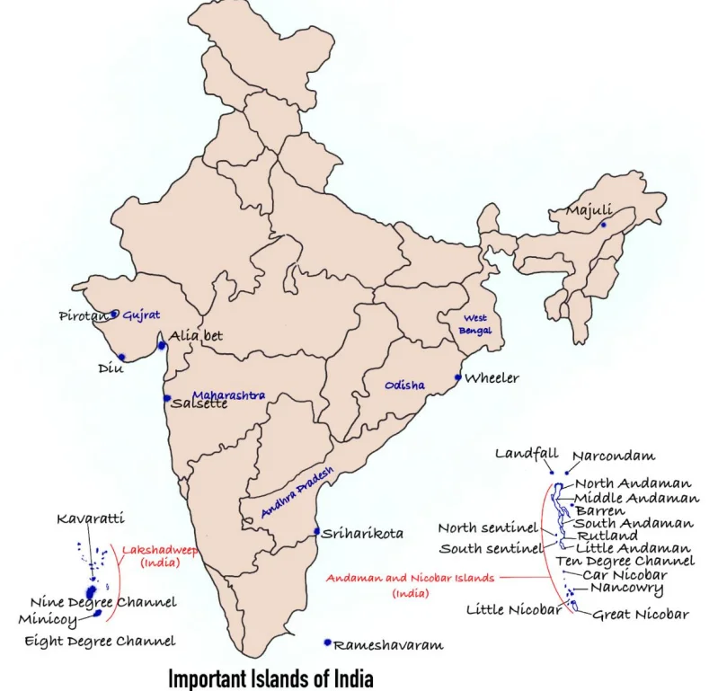
1. Lakshadweep Group (लक्षद्वीप समूह)
What are they? These are Coral Atolls. Imagine millions of tiny sea creatures called 'Polyps' dying over thousands of years. Their skeletons pile up to form hard rock-like structures called Corals. When these corals form a ring shape with a lake (lagoon) in the middle, it is called an Atoll. Lakshadweep is a collection of such Atolls.
Geography: It is the smallest Union Territory of India. It consists of three main subgroups:
- Amindivi Islands: The northernmost group.
- Laccadive Islands: The middle group (where the capital Kavaratti is located).
- Minicoy Island: The southernmost and largest individual island. It is culturally closer to the Maldives (people speak Mahal language).
2. Important Channels (महत्वपूर्ण चैनल)
These are water bodies that separate the islands. You must remember these for exams:
- 11 Degree Channel: Separates Amindivi (North) from Laccadive (South).
- 9 Degree Channel: Separates the main Lakshadweep group from Minicoy Island.
- 8 Degree Channel: Separates Minicoy Island from the country of Maldives.
3. Other Strategically Important Islands (अन्य रणनीतिक रूप से महत्वपूर्ण द्वीप)
Sriharikota (Andhra Pradesh): Located near Chennai. It is a Barrier Island separating Pulicat Lake from the Bay of Bengal. It is famous because India launches all its rockets (Chandrayaan, Mangalyaan) from the Satish Dhawan Space Centre here.
Wheeler Island (Odisha): Now called Dr. Abdul Kalam Island. It is a military facility used exclusively for testing missiles (like Agni and Prithvi). Civilians are not allowed here.
Majuli (Assam): Situated in the middle of the mighty Brahmaputra river. It is the world's largest river island. It is the cultural capital of Assam (famous for Satriya dance and monasteries).
Salsette Island (Maharashtra): Most people don't realize this, but the mega-city of Mumbai is built on this island. It is separated from the mainland by Thane Creek.
Pamban Island (Tamil Nadu): Also known as Rameswaram Island. It forms the first link of the Ram Setu (Adam's Bridge) connecting India to Sri Lanka.
| Island | Key Feature |
|---|---|
| Lakshadweep | Coral islands; 36 total, 11 inhabited; Minicoy is largest. |
| Majuli (Assam) | World’s largest freshwater island; first island district. |
| Salsette (Maharashtra) | Mumbai city located here. |
| Sriharikota (AP) | Barrier island; ISRO satellite launch site. |
| Aliabet (Gujarat) | First offshore oil well site of India. |
| Wheeler Island (Odisha) | Missile testing station (Abdul Kalam Island). |
| Pirotan (Gujarat) | Marine National Park islands; mangroves present. |
| Diu (Gujarat) | South of Kathiawar Peninsula. |
| Rameshwaram (TN) | Near Sri Lanka; linked by Pamban Bridge. |
| Hope Island (AP) | Tadpole-shaped island in Bay of Bengal. |
Prelims tips
- Lakshadweep = smallest UT; entirely coral origin.
- Minicoy = largest island; south of Nine Degree Channel.
- Majuli (Assam) = world’s largest freshwater island.
- Sriharikota = ISRO launch site (AP).
- Rameshwaram = linked to mainland by Pamban Bridge.
Mains points
- Lakshadweep islands are ecologically fragile (coral reefs, lagoons) and vulnerable to sea-level rise.
- They are strategically important in the Arabian Sea for India’s naval and trade routes.
- Other islands like Sriharikota and Wheeler are vital for space and defense programs.
- Majuli highlights India’s unique riverine island ecosystem and cultural heritage.
- Rameshwaram and Diu are culturally and historically significant coastal islands.
Himalayan Hazards: Landslides, Land Subsidence and GLOFs
The Himalaya are young, tectonically active fold mountains with steep slopes, fragile rocks and intense monsoon rain, making them prone to earthquakes, landslides, cloudbursts, land subsidence and glacial lake outburst floods (GLOFs). Disasters at Kedarnath (2013), Chamoli (2021), Joshimath (2023) and the South Lhonak GLOF in Sikkim (2023) show how unplanned development amplifies natural hazards.
1. Why the Himalaya Are Hazard-Prone
Tectonics: The Indian plate continues to push into the Eurasian plate; the region lies in high seismic zones and has major thrusts (Main Central Thrust, Main Boundary Thrust).
Geology: Young, folded, fractured and weathered rocks; loose glacial and river deposits.
Climate: Heavy monsoon rain, cloudbursts (more than 100 mm of rain in an hour over a small area), rapid snowmelt.
Warming: Glacier retreat creates and enlarges glacial lakes held by unstable moraine dams.
2. Major Hazards
Landslides: The ISRO Landslide Atlas of India (2023) ranks Rudraprayag and Tehri Garhwal (Uttarakhand) among the districts with the highest landslide exposure; the Geological Survey of India is the nodal agency for landslides.
Land subsidence: Joshimath (January 2023)—cracks in hundreds of houses; the town is built on old landslide debris. The M.C. Mishra Committee (1976) had warned against heavy construction there.
GLOFs: Sudden release of water from glacial lakes—South Lhonak lake (Sikkim, October 2023) destroyed the Teesta-III dam at Chungthang. NDMA has issued GLOF guidelines and identified high-risk lakes for monitoring.
Cloudbursts and flash floods: Kedarnath (June 2013)—extreme rain and the Chorabari lake breach killed thousands.
Rock–ice avalanches: Chamoli (February 2021)—debris flow in the Rishiganga and Dhauliganga damaged hydropower projects.
3. Human Factors
Unplanned construction on slopes, road widening with vertical cuts (e.g. Char Dham roads), tunnelling and blasting for hydropower, deforestation, poor drainage, and tourism pressure beyond carrying capacity.
4. Measures
Hazard zonation and building codes; carrying-capacity studies for hill towns and pilgrimage routes; early warning for landslides and GLOFs; lowering lake levels and monitoring with satellites; slope stabilisation using bio-engineering; restricting construction in high-risk zones.
Institutions: NDMA, GSI, ISRO-NRSC, Wadia Institute of Himalayan Geology, state disaster authorities; National Mission for Sustaining the Himalayan Ecosystem under the NAPCC.
5. Way Forward
A Himalayan development model based on ecological limits: environmental impact assessments that consider cumulative impacts, community-based early warning, and regional cooperation on glacier and river data.
| Event | Year | Hazard type |
|---|---|---|
| Kedarnath, Uttarakhand | 2013 | Cloudburst, glacial lake breach, flash flood |
| Chamoli, Uttarakhand | 2021 | Rock–ice avalanche, debris flow |
| Joshimath, Uttarakhand | 2023 | Land subsidence |
| South Lhonak, Sikkim | 2023 | Glacial lake outburst flood |
Prelims tips
- GSI is the nodal agency for landslide studies in India.
- Landslide Atlas of India was released by ISRO's NRSC in 2023.
- South Lhonak GLOF (2023) damaged the Teesta-III dam in Sikkim.
- M.C. Mishra Committee (1976) studied Joshimath's instability.
- A cloudburst is about 100 mm or more of rain in an hour over a small area.
Mains points
- Himalayan disasters are 'natural hazards, human disasters': development ignoring geology turns hazards into catastrophes.
- Hydropower and roads bring development and strategic connectivity but need cumulative impact assessment and safer engineering.
- Climate change is increasing GLOF and cloudburst risks, requiring glacier monitoring and early warning.
- Carrying-capacity limits for tourism and pilgrimage are essential in fragile towns.
- Local and traditional knowledge (stone houses, settlement siting) should inform modern planning.
Did you know?
- The Himalaya are still rising by a few millimetres a year as the Indian plate pushes north.
- Traditional 'Koti Banal' houses in Uttarakhand, built with wood and stone, have survived earthquakes for centuries.
- Chorabari Tal above Kedarnath was also called Gandhi Sarovar.
Indian & Physical Geography: All chapters
- The Universe and the Earth
- Atmosphere and Its Composition
- Atmospheric Temperature
- Atmospheric Moisture
- Air Mass, Fronts & Cyclones
- Evolution of Earth's Crust, Earthquakes and Volcanoes
- Interior of the Earth
- Landforms
- Geomorphic Processes
- Movement of Ocean Water
- Oceans and Their Properties
- Climate of a Region
- Indian Geography: Introduction and Geology
- Physiography of India
- Indian Climate
- Indian Drainage
- Soil and Natural Vegetation
- Mineral and Energy Resources, Industries in India
- Indian Agriculture
- Population, Migration and Urbanisation