
Indian & Physical Geography · UPSC Notes
Atmospheric Moisture — UPSC Geography Notes
Free, exam-focused notes for UPSC Prelims and Mains, with Prelims tips and Mains points for every topic. 9 topics.
Open in the interactive reader: bookmarks, progress tracking and read-aloud.
Atmospheric Moisture – Hydrological Cycle
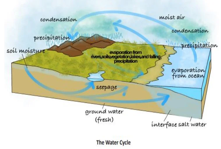
The hydrological cycle is the continuous circulation of water between the Earth’s surface and atmosphere through processes like evaporation, transpiration, condensation, precipitation, infiltration, and runoff.
A. Definition
The Hydrological Cycle , also known as the Water Cycle , is the continuous and endless circulation of water between the Earth's surface, the atmosphere, and back again. It involves several processes that move water through its different forms — liquid, vapor, and ice — across oceans, land, and air.
In simple terms, water from oceans, lakes, and rivers evaporates, forms clouds, falls as rain or snow, and returns again through rivers and groundwater, maintaining the global water balance.
B. Steps Involved in the Hydrological Cycle
1. Evaporation: The Sun’s energy heats water bodies such as oceans, lakes, and rivers, causing water to change into vapor and rise into the atmosphere.
2. Transpiration: Plants also release water vapor through tiny pores called stomata during photosynthesis — this process is called transpiration.
3. Evapotranspiration: The combined process of evaporation from land and water surfaces and transpiration from plants.
4. Condensation: As water vapor rises, it cools and condenses into tiny droplets, forming clouds. This is where latent heat is released into the atmosphere, fueling weather systems.
5. Precipitation: When cloud droplets combine and grow large enough, they fall to Earth as rain, snow, sleet, or hail depending on temperature conditions.
6. Infiltration: Part of the precipitation seeps through soil and rocks into underground layers, becoming groundwater .
7. Runoff: Remaining water flows over the surface (surface runoff) or underground (subsurface flow) and eventually returns to oceans and seas, completing the cycle.
C. Importance of the Hydrological Cycle
1. Global Water Balance: It maintains equilibrium between evaporation and precipitation across the planet.
2. Freshwater Distribution: Responsible for the formation of rivers, lakes, and groundwater — crucial sources of drinking water.
3. Climate Regulation: Controls temperature and humidity by transferring heat and moisture in the atmosphere.
4. Soil Moisture Recharge: Helps maintain soil fertility, vital for agriculture.
5. Supports Ecosystems: Provides water for plants, animals, and all forms of life, ensuring biodiversity.
6. Energy Transfer: During condensation, latent heat is released — this drives storms, monsoons, and global wind patterns .
D. Major Water Reservoirs on Earth
1. Oceans: Contain about 97% of the Earth’s total water — mostly saline.
2. Ice Caps and Glaciers: Contain nearly 2% of Earth’s water in frozen form — a major part of the freshwater reserve.
3. Groundwater: Accounts for about 0.7% — a key source for drinking and irrigation.
4. Surface Water: Rivers, lakes, and ponds together form less than 0.01% but are vital for life.
5. Atmosphere: Contains a tiny fraction of water vapor, yet plays a major role in rainfall, storms, and weather systems.
E. Human Impacts on the Hydrological Cycle
1. Deforestation: Reduces transpiration, decreases local rainfall, and alters the natural water balance.
2. Over-extraction of Groundwater: Excessive pumping lowers water tables and causes aquifer depletion.
3. Urbanization: Paved surfaces prevent infiltration, increasing surface runoff and causing floods.
4. Pollution: Industrial waste and chemicals contaminate rivers and groundwater, reducing freshwater availability.
5. Climate Change: Raises global temperatures, leading to more intense evaporation and precipitation — causing droughts in some areas and floods in others.
6. Dam Construction: Alters natural river flow, disrupting the balance of evaporation, infiltration, and runoff.
F. Role in Global Heat and Moisture Transfer
1. The hydrological cycle acts as a natural heat engine for the planet.
2. When water vapor condenses into clouds, it releases latent heat , which powers storms, cyclones, and monsoon systems.
3. It helps in transferring heat energy from the equator (warm regions) to the poles (cold regions) , maintaining global temperature balance.
4. Thus, the water cycle not only regulates rainfall and humidity but also contributes significantly to Earth's climate stability.
G. Summary for Beginners
1. The hydrological cycle is a never-ending movement of water through evaporation, condensation, precipitation, and runoff.
2. It connects the oceans, atmosphere, and land in a continuous exchange of water and energy.
3. It is essential for life, agriculture, weather, and climate.
4. Human actions like deforestation and urbanization are disturbing this balance, leading to droughts, floods, and water scarcity.
| Reservoir | Percentage of Total Water |
|---|---|
| Oceans | 97% |
| Ice Caps & Glaciers | 2% |
| Groundwater | 0.7% |
| Surface Water (Rivers, Lakes) | <0.01% |
| Atmosphere | Trace but vital |
Prelims tips
- Evapotranspiration = evaporation + transpiration.
- Groundwater = infiltrated water stored underground.
- Latent heat of condensation drives monsoons & storms.
- Oceans hold ~97% of Earth’s water.
Mains points
- Hydrological cycle maintains global water and energy balance.
- Involves evaporation, transpiration, condensation, precipitation, infiltration, runoff.
- Distributes freshwater across rivers, lakes, groundwater.
- Human activities like deforestation and urbanization alter the cycle.
- Key link between atmosphere, lithosphere, and biosphere.
Humidity
Humidity is the amount of water vapor present in the air. It is expressed in different forms: absolute, specific, and relative humidity. Relative humidity is especially important for weather forecasting, cloud formation, and rainfall prediction.
A. Definition
Humidity refers to the amount of water vapor present in the air at any given time. It is one of the most important meteorological elements influencing weather, human comfort, and climate.
Water vapor is an invisible gaseous form of water, and its concentration varies depending on temperature, location, and proximity to water sources like oceans, lakes, and forests.
Humidity plays a major role in cloud formation, rainfall, and the Earth’s energy balance.
B. Different Expressions of Humidity
1. Absolute Humidity:
It is the mass of water vapor present in a unit volume of air.
Expressed in grams per cubic meter (g/m³) .
It tells how much water vapor is actually in a given air volume.
It decreases from the equator toward the poles due to temperature differences.
Absolute humidity changes with temperature and pressure — warm air can hold more water vapor.
Example: In humid tropical regions, absolute humidity is much higher than in polar regions.
2. Specific Humidity:
It is the mass of water vapor per unit mass of air (including dry air and water vapor).
Expressed in grams of water vapor per kilogram of air (g/kg) .
It does not change when air expands or contracts, making it useful for comparing humidity at different altitudes.
Example: Used in meteorological studies and weather forecasting for accuracy.
3. Relative Humidity (RH):
It is the ratio (in percentage) of the actual amount of water vapor present in the air to the maximum amount the air can hold at that temperature.
Formula: RH = (Actual Water Vapor / Maximum Water Vapor Capacity) × 100
Expressed in percentage (%) .
Relative humidity depends strongly on temperature — when temperature increases, the air’s capacity to hold moisture increases, lowering RH if vapor content remains constant.
Example: In summer, even with the same moisture content, RH is lower due to higher temperatures.
C. Factors Influencing Humidity
1. Temperature: Warm air can hold more moisture. Hence, tropical areas are more humid than polar regions.
2. Proximity to Water Bodies: Areas near seas, oceans, or lakes have higher humidity due to continuous evaporation.
3. Wind Direction: Moist winds from the sea increase humidity, while dry continental winds decrease it.
4. Vegetation: Plants release water vapor through transpiration, raising humidity in forested regions.
5. Altitude: As altitude increases, air becomes thinner and cooler, reducing its moisture-holding capacity and humidity.
6. Topography: Valleys and coastal areas often have higher humidity compared to mountains or plateaus.
D. Importance of Humidity
1. Weather Formation: High humidity helps in the formation of clouds, fog, and rainfall.
2. Agriculture: Humidity affects soil moisture, plant growth, and transpiration rate — crucial for crop yield.
3. Climate and Comfort: High humidity makes warm weather feel hotter (due to less evaporation of sweat), while low humidity causes dry skin and irritation.
4. Health: High RH favors fungal growth, mold, and respiratory issues; very low RH leads to dryness and dehydration.
5. Industrial Importance: Textile, printing, and electronic industries maintain controlled humidity levels to prevent damage to materials.
6. Natural Processes: Humidity regulates rainfall patterns and hydrological balance globally.
E. Measurement of Humidity
1. Hygrometer: General instrument used for measuring humidity levels.
2. Psychrometer: Uses two thermometers — one dry bulb and one wet bulb. The difference between their readings helps determine relative humidity.
3. Hair Hygrometer: Based on the principle that human or animal hair changes length with varying humidity levels.
4. Dew Point Measurement: The temperature at which air becomes saturated and condensation begins; indicates humidity indirectly.
F. Difference between Absolute and Relative Humidity
Absolute Humidity: Measures the actual amount of water vapor in the air. Expressed in g/m³. It is independent of temperature and shows how much water vapor is physically present.
Relative Humidity: Measures the percentage of water vapor the air holds relative to its maximum capacity at a given temperature. Expressed in %. It changes with temperature and indicates the likelihood of rainfall or dew formation.
G. Practical Examples
When warm moist air from the sea blows over land, RH increases and may lead to cloud formation and rain.
In deserts, despite high temperatures, RH remains very low — causing dryness and discomfort.
Air-conditioned rooms have low RH; hence humidifiers are used to maintain comfort.
During early morning, RH is highest; as the day progresses and temperature rises, RH decreases.
| Type | Definition | Unit/Expression |
|---|---|---|
| Absolute Humidity | Actual vapor in unit volume of air | g/m³ |
| Specific Humidity | Vapor in unit weight of air | g/kg |
| Relative Humidity | Percentage ratio of actual vapor to capacity | % |
Prelims tips
- Relative humidity decreases with rising temperature if moisture remains constant.
- Absolute humidity is not directly dependent on temperature.
- Relative humidity is crucial in forecasting rainfall, fog, and dew.
- Measured using hygrometers, psychrometers, and hair hygrometers.
Mains points
- Humidity regulates cloud formation, precipitation, and weather systems.
- Relative humidity is most relevant for human comfort and agriculture.
- Absolute humidity helps calculate precipitation potential.
- Specific humidity is useful in climate studies as it remains unaffected by volume changes.
- Variations in humidity influence local and global climate systems.
Phase Changes of Water
Water exists in three states – solid, liquid, and gas. The transformation between these states involves phase changes such as evaporation, condensation, sublimation, melting, freezing, and deposition, which play a critical role in the Earth’s atmospheric processes and energy balance.
A. Evaporation (वाष्पीकरण)
Evaporation is the process of converting liquid water into water vapor by the action of heat. It is a key part of the hydrological cycle and responsible for the transfer of water from oceans, rivers, and soil into the atmosphere.
Characteristics and Factors:
1. Process: Liquid water → Water vapor (on heating).
2. Faster in dry air: Since dry air has more capacity to absorb water vapor, evaporation is rapid in arid areas.
3. Higher over oceans: Due to vast water surfaces and wind action, oceans experience more evaporation than land areas.
4. Influencing Factors:
- Temperature: Higher temperature → faster evaporation.
- Humidity: Lower humidity → faster evaporation.
- Wind speed: Stronger winds remove saturated air → increases evaporation.
- Aridity: Dry climate promotes more evaporation.
5. Latent Heat of Vaporization: It is the energy absorbed during evaporation without changing temperature — this energy is stored in water vapor as latent heat and released later during condensation.
6. Significance: Evaporation cools the Earth’s surface (oceans, soil, and vegetation) and adds moisture to the atmosphere, influencing weather and climate.
B. Condensation (संघनन)
Condensation is the process by which water vapor changes back into liquid water when air cools down to its saturation point.
It is the reverse of evaporation and is responsible for cloud, fog, and dew formation.
How Condensation Occurs:
1. Cooling of moist air: When warm, moist air cools, its water vapor condenses into tiny water droplets.
2. Causes of Cooling:
- Air rises and expands adiabatically (without heat exchange).
- Warm air comes in contact with a colder surface (radiation cooling).
- Mixing of warm moist air with cold air.
3. Condensation Nuclei: Tiny particles like dust, smoke, sea salts, or CO₂ act as centers where water vapor condenses — these are called hygroscopic nuclei .
4. Latent Heat Release: During condensation, water vapor releases the same latent heat that was absorbed during evaporation — this energy drives cloud formation, rainfall, and storms.
5. Sublimation: When water vapor condenses directly into solid ice (without becoming liquid first), it is called sublimation .
C. Dew Point (ओसांक)
The Dew Point is the temperature at which air becomes saturated with water vapor and condensation begins.
Below the dew point, air cannot hold more moisture, leading to the formation of dew, fog, frost, or clouds depending on temperature conditions.
Example: On a cold morning, grass gets covered with dew when the air cools below its dew point.
If temperature is below 0°C, frost forms instead of dew.
D. Other Phase Changes of Water
1. Sublimation: Direct change from solid (ice/snow) to gas (water vapor) without becoming liquid. Common in very dry and cold regions such as the Himalayas and Antarctica.
2. Deposition: Direct change from water vapor to solid ice (e.g., frost formation on cold surfaces).
3. Freezing: Conversion of liquid water into ice. Heat is released during this process, known as the latent heat of fusion .
4. Melting: Ice changes into liquid water by absorbing heat (latent heat of fusion).
E. Significance of Phase Changes in the Atmosphere
1. Energy Balance: Evaporation absorbs heat (cooling effect), while condensation releases it (warming effect). Together, they regulate Earth’s energy balance.
2. Weather Formation: Condensation and freezing release latent heat, providing energy for cloud development, rainfall, cyclones, and thunderstorms.
3. Cooling Effect: Evaporation cools the Earth’s surface — especially oceans and plants — maintaining local temperature balance.
4. Polar & Glacial Processes: Sublimation and deposition influence snow, glaciers, and polar climate systems.
5. Climate Regulation: These phase changes are key in the hydrological cycle and help in transferring heat from equator to poles, stabilizing global climate.
F. Summary (For Beginners)
Evaporation = water turns to vapor (absorbs heat).
Condensation = vapor turns to liquid (releases heat).
Dew Point = temperature when condensation starts.
Sublimation/Deposition = direct change between solid and gas.
These processes together drive Earth’s water cycle and control weather and climate .
| Process | Change | Energy |
|---|---|---|
| Evaporation | Liquid → Gas | Absorbs latent heat (cooling) |
| Condensation | Gas → Liquid | Releases latent heat (warming) |
| Sublimation | Solid → Gas | Absorbs latent heat |
| Deposition | Gas → Solid | Releases latent heat |
| Freezing | Liquid → Solid | Releases latent heat of fusion |
| Melting | Solid → Liquid | Absorbs latent heat of fusion |
Prelims tips
- Evaporation absorbs heat, condensation releases heat.
- Dew point = temperature at which air becomes saturated.
- Hygroscopic nuclei essential for cloud formation.
- Latent heat drives monsoons, storms, and atmospheric circulation.
Mains points
- Phase changes of water are fundamental to weather and climate dynamics.
- Evaporation cools surfaces; condensation warms atmosphere.
- Latent heat exchange is critical for monsoon rainfall and storm systems.
- Processes like sublimation and deposition are vital in cryosphere and glacial studies.
- Understanding phase changes helps in predicting precipitation, fog, frost, and cloud dynamics.
Forms of Condensation
Condensation appears in various forms like dew, frost, fog, mist, haze, and clouds. Each form depends on temperature, humidity, dew point, and presence of condensation nuclei. These forms impact weather, agriculture, visibility, and human activities.
A. Dew (ओस)
Definition and Formation:
Dew forms when moist air comes in contact with cool surfaces (like grass, leaves, or soil) during clear, calm nights. When the temperature of the surface falls below the dew point (but above 0°C), the water vapor condenses into tiny liquid droplets.
Ideal Conditions for Dew Formation:
1. Clear skies (maximum radiation cooling at night).
2. Calm or light winds (prevents mixing of air layers).
3. High relative humidity (near saturation).
4. Long, cool nights (allow sufficient cooling).
5. Dew point above freezing (temperature > 0°C).
Importance:
Provides moisture to plants in arid and semi-arid regions where rainfall is low.
Helps maintain microclimate humidity beneficial for small crops and grasses.
Early morning dew prevents desiccation of plants in deserts.
B. Fog (कोहरा)
Definition:
Fog is a cloud formed at or near the ground . It consists of tiny water droplets suspended in the air, reducing visibility to less than 1 km .
Formation Conditions:
1. Cooling of moist air to its dew point temperature.
2. High humidity near the surface.
3. Presence of hygroscopic nuclei (dust, smoke, salts).
Major Types of Fog:
1. Radiation Fog: Forms on clear, calm nights when the ground loses heat by radiation and cools the air near the surface.
- Common in valleys and plains (e.g., Indo-Gangetic plains).
2. Advection Fog: Forms when warm, moist air moves over a cooler surface , cooling it to dew point (e.g., coastal regions like San Francisco).
3. Valley Fog: Occurs in mountain valleys where cold, dense air settles at the bottom and traps moisture.
4. Steam Fog (Evaporation Fog): Occurs when cold air moves over warm water and water vapor rises and condenses immediately.
Impacts:
Reduces visibility → hazardous for aviation, road, and marine transport.
May disrupt daily life, cause delays, and increase accident risks.
C. Mist (धुंध)
Definition:
Mist is a thin or light fog with slightly better visibility than fog (1–2 km). It usually forms when warm, moist air comes into contact with a cooler surface.
Occurrence:
Common in mountain regions and near waterfalls due to cooling and condensation.
Can occur naturally, volcanically (steam vents), or artificially (cooling towers).
Characteristics:
Contains very fine water droplets.
Gives a soft, bluish appearance to the atmosphere.
D. Haze (कुहासा)
Definition:
Haze refers to the reduction in visibility (2–5 km) caused by suspended dry particles such as dust, smoke, and pollutants — without involving moisture.
Key Differences from Fog:
Fog forms due to condensed water droplets , while haze is due to dry particles .
Fog usually forms in humid conditions, haze in dry and polluted air.
Causes:
Urban and industrial pollution (vehicle emissions, factories).
Dust storms, forest fires, or volcanic activity.
Impacts:
Health hazards: respiratory irritation, asthma.
Decreased visibility → affects transportation and solar radiation reaching the surface.
E. Frost (पाला)
Definition:
Frost is frozen dew formed when the dew point falls below 0°C , and water vapor changes directly into ice crystals through deposition .
Types of Frost:
1. Ground Frost: Ice forms on surfaces (grass, soil) that are below freezing, even if air above is slightly warmer.
2. Air Frost: When air temperature at 1 m height drops to or below 0°C.
3. Hoar Frost: Feathery, white ice crystals form directly from vapor deposition under freezing conditions.
4. Rime: Rough, opaque ice deposit formed when supercooled fog droplets freeze upon contact with cold, wind-exposed surfaces (e.g., mountain tops).
5. Glaze (Clear Ice): Transparent, smooth ice layer formed when supercooled rain freezes upon contact with cold surfaces — extremely slippery and hazardous.
Significance:
Damages crops like potatoes, grapes, apples — critical for agriculture.
Affects transportation and power lines (due to ice accumulation).
Indicates low nighttime temperature and radiational cooling.
F. Clouds (बादल)
Definition:
Clouds are visible accumulations of tiny water droplets or ice crystals suspended in the air, formed through condensation of water vapor around dust or salt particles.
Importance of Clouds:
1. Weather Indicators: Type, shape, and height of clouds help predict upcoming weather (rain, storm, fair weather).
2. Climate Role: Clouds reflect sunlight (albedo effect) and trap heat, influencing Earth’s energy balance.
3. Precipitation: Clouds are the source of rainfall, snow, and hail.
4. Water Cycle: Integral part of the hydrological cycle, maintaining moisture distribution.
Additional Note:
Cloud classification is based on height and appearance (e.g., Cirrus, Cumulus, Stratus, Nimbus).
High clouds are mostly icy (cirrus), while low clouds are dense and can produce rain (stratus, nimbus).
| Form | Visibility | Special Feature |
|---|---|---|
| Dew | Not applicable | Water droplets on surfaces |
| Fog | < 1 km | Cloud near ground, dense |
| Mist | 1–2 km | Light fog, common in mountains |
| Haze | 2–5 km | Dry particles, pollution-related |
| Frost | Not applicable | Frozen dew, crop damage |
| Clouds | Sky phenomenon | Main condensation form, precipitation source |
Prelims tips
- Fog = cloud near surface, visibility < 1 km.
- Mist = thin fog, visibility 1–2 km.
- Haze caused by dust/smoke, not moisture.
- Frost types: ground, air, hoar, rime, glaze.
- Dew point above freezing → dew; below freezing → frost.
Mains points
- Condensation appears in multiple forms depending on temperature, humidity, and surface conditions.
- Dew and frost are ground-level condensations; fog, mist, haze affect visibility and transportation.
- Frost significantly impacts agriculture and ecosystems.
- Clouds are the most significant condensation form for weather and rainfall.
- Understanding condensation helps in weather prediction, aviation safety, and crop management.
Clouds
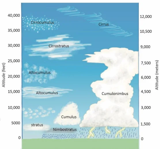
Clouds are visible masses of condensed water vapor or ice crystals suspended in the atmosphere. They form when moist air rises, cools, and condenses around dust or other condensation nuclei. Clouds are classified by altitude and form, and they play a crucial role in weather and climate.
A. Formation of Clouds
Clouds form when warm, moist air rises and cools adiabatically (without exchange of heat). As the air rises, pressure decreases, causing it to expand and cool.
When the temperature of the rising air falls to the dew point , the water vapor condenses around microscopic particles like dust, smoke, sea salts, or pollen — called condensation nuclei .
These condensed water droplets or ice crystals cluster together to form clouds.
The height of cloud formation varies with atmospheric conditions — from a few hundred meters to nearly 20 km — depending on humidity, temperature, and vertical air motion.
In general:
Near the surface → Stratus and fog clouds form.
Middle levels → Altostratus and Altocumulus clouds appear.
High altitudes → Cirrus clouds made of ice crystals dominate.
B. Major Types of Clouds
1. Cirrus Clouds (Ci)
Altitude: High-level clouds (8,000–12,000 m).
Appearance: Thin, white, hair-like or feathery clouds made of ice crystals.
Weather Indication: Generally fair but cool weather; often appear 24–48 hours before a storm or cyclone.
Example: ‘Mare’s tail’ shaped cirrus clouds are early signs of changing weather.
2. Cumulus Clouds (Cu)
Altitude: Middle level (4,000–7,000 m).
Appearance: Puffy, cotton-like, dome-shaped clouds with flat bases and cauliflower tops.
Weather Indication: Usually fair weather but can develop vertically into cumulonimbus clouds, producing thunderstorms and heavy rain.
Formation: Due to strong convection and rising warm air currents (common in summer).
3. Stratus Clouds (St)
Altitude: Low-level clouds (below 2,000 m).
Appearance: Grayish, uniform layers covering the entire sky, often producing dull and overcast conditions.
Weather Indication: Usually brings light rain, drizzle, or fog-like conditions.
Formation: Due to gentle lifting or cooling of moist air, or mixing of warm and cold air masses.
4. Nimbus Clouds (Ns)
Altitude: Found near surface or mid-levels.
Appearance: Dark, thick, and dense clouds — often covering large areas.
Weather Indication: Continuous, steady rain or snow.
Special Case: Cumulonimbus clouds (Cb) are towering thunderstorm clouds reaching up to 12–15 km, often producing lightning, thunder, and heavy rainfall.
C. Height-Based Classification of Clouds
1. High Clouds (6,000–20,000 m):
Cirrus (Ci): Feathery, ice-crystal clouds.
Cirrostratus (Cs): Thin, milky veil across the sky, sometimes creating halos around the sun or moon.
Cirrocumulus (Cc): Small, white patches arranged in ripples — also called ‘mackerel sky’.
2. Middle Clouds (2,000–6,000 m):
Altostratus (As): Gray-blue sheets covering the sky, leading to steady rain.
Altocumulus (Ac): Rounded, patchy clouds appearing before thunderstorms or cold fronts.
3. Low Clouds (Surface–2,000 m):
Stratus (St): Layered, flat clouds bringing drizzle.
Stratocumulus (Sc): Large, lumpy clouds forming under temperature inversion layers.
Nimbostratus (Ns): Thick, dark clouds producing prolonged rainfall or snow.
4. Clouds of Vertical Development:
Cumulus (Cu): Fair-weather clouds that can vertically grow.
Cumulonimbus (Cb): Towering thunderstorm clouds extending from low to high altitudes (can reach the stratosphere). They produce lightning, thunder, hail, and sometimes tornadoes.
D. Special Clouds
Lenticular Clouds: Lens-shaped clouds formed on the windward side of mountains due to airflow disturbances; often mistaken for UFOs.
Mammatus Clouds: Bulging, pouch-like formations under cumulonimbus bases, indicating severe weather or turbulence.
Noctilucent Clouds: Very high clouds (in mesosphere, ~80 km) made of ice crystals, visible only at twilight when illuminated by the sun below the horizon.
E. Significance of Clouds
1. Weather Prediction: Cloud type, color, and movement help meteorologists forecast weather conditions (e.g., cirrus = change in weather, cumulonimbus = storm).
2. Hydrological Cycle: Clouds are essential for precipitation and water recycling on Earth.
3. Climate Regulation: Clouds reflect sunlight (cooling effect) and trap heat (warming effect), thus balancing Earth’s temperature.
4. Aviation: Cloud cover affects flight safety — cumulonimbus and fog are major hazards.
5. Ecological Importance: Provide shade, influence evapotranspiration, and moderate local climates.
| Altitude | Types | Characteristics |
|---|---|---|
| High (6–20 km) | Cirrus, Cirrostratus, Cirrocumulus | Thin, icy, wispy |
| Middle (2–6 km) | Altostratus, Altocumulus | Layered, puffy, liquid water |
| Low (0–2 km) | Stratus, Stratocumulus, Nimbostratus | Dense, layered, rain-bearing |
| Vertical | Cumulus, Cumulonimbus | Towering, thunderstorm clouds |
Prelims tips
- Cirrus = ice crystals, high altitude, fibrous.
- Nimbus clouds are rain-bearing.
- Cumulonimbus = thunderstorm, vertical growth.
- Stratus = layered, low altitude.
- Noctilucent clouds = mesosphere, twilight visible.
Mains points
- Clouds are classified based on altitude and form: high, middle, low, vertical.
- Cirrus clouds indicate fair weather but may precede storms.
- Stratus clouds lead to overcast skies and drizzle; nimbus indicates rain.
- Cumulonimbus clouds are storm-bearing with vertical development.
- Special clouds (lenticular, mammatus, noctilucent) provide clues about turbulence and atmospheric dynamics.
- Cloud study is essential for weather forecasting, aviation, and climate studies.
Clouds and Their Subtypes
Clouds are classified into four main families based on altitude: High, Middle, Low, and Vertical development. Each family has subtypes with distinct characteristics, appearance, and weather significance.
🌤 High Clouds (6–20 km altitude)
These clouds form in the upper troposphere where temperatures are below freezing. They are composed mainly of ice crystals and rarely produce precipitation that reaches the ground.
Cirrus (Ci)
Appearance: Thin, wispy, feather-like white clouds.
Composition: Ice crystals.
Weather Indication: Fair and pleasant weather but often seen 24–48 hours before a storm or cyclone.
Example: ‘Mare’s tail’ cirrus clouds often indicate jet stream activity.
Cirrostratus (Cs)
Appearance: Transparent, veil-like clouds covering the entire sky.
Features: Form halos around the Sun or Moon due to refraction through ice crystals.
Weather Indication: Usually precede rain or snow within 24 hours.
Cirrocumulus (Cc)
Appearance: Small, patchy, rippled clouds — known as ‘mackerel sky’.
Composition: Ice crystals or supercooled droplets.
Weather Indication: Sign of unsettled or changing weather.
☁️ Middle Clouds (2–6 km altitude)
These clouds consist of water droplets and sometimes ice crystals. They often indicate upcoming precipitation or weather transitions.
Altostratus (As)
Appearance: Gray or bluish sheets covering most of the sky; Sun appears dim or hazy.
Formation: Form ahead of warm fronts.
Weather Indication: Signal of steady rain or snow approaching.
Altocumulus (Ac)
Appearance: Puffy, layered patches often forming in rows.
Time of Occurrence: Common on warm, humid mornings before thunderstorms.
Weather Indication: Precedes unsettled or stormy weather.
🌫 Low Clouds (Surface–2 km altitude)
These clouds form near the Earth’s surface and mainly consist of water droplets. They often bring drizzle, fog, or continuous rain.
Stratus (St)
Appearance: Uniform gray layer covering large portions of the sky; may resemble fog above the ground.
Weather Indication: Produces drizzle or light mist; indicates dull, overcast conditions.
Stratocumulus (Sc)
Appearance: Low, lumpy, gray clouds with breaks showing blue sky.
Weather Indication: Usually dry or may bring light rain; indicate stable weather after a storm.
Nimbostratus (Ns)
Appearance: Dark, thick, layered clouds blocking sunlight.
Weather Indication: Continuous, widespread rain or snow lasting several hours or days.
⛈ Clouds of Vertical Development
These clouds grow vertically due to strong convection currents. They can extend from low altitudes to the upper troposphere and are associated with thunderstorms.
Cumulus (Cu)
Appearance: White, puffy clouds with flat bases and cauliflower-like tops.
Weather Indication: Fair weather clouds, but when they grow taller, they can develop into cumulonimbus.
Formation: Formed due to daytime heating and rising warm air currents.
Cumulonimbus (Cb)
Appearance: Towering, anvil-shaped massive clouds reaching up to the stratosphere.
Weather Indication: Thunderstorms, lightning, heavy rain, hail, and even tornadoes.
Significance: One of the most powerful weather-producing clouds in the troposphere.
| Family | Type | Form | Characteristics |
|---|---|---|---|
| High | Cirrus (Ci) | Cirriform | Wispy, icy, fair weather, storm precursors |
| High | Cirrostratus (Cs) | Cirriform | Veil-like, halo, pre-rain/snow indicator |
| High | Cirrocumulus (Cc) | Cirriform | Rippled 'mackerel sky', unsettled weather |
| Middle | Altostratus (As) | Stratiform | Gray sheets, Sun dimly visible, pre-storm |
| Middle | Altocumulus (Ac) | Cumuliform | Layered puffy, storm indicator |
| Low | Stratus (St) | Stratiform | Gray layer, drizzle/mist |
| Low | Stratocumulus (Sc) | Stratiform | Lumpy, breaks, light rain |
| Low | Nimbostratus (Ns) | Stratiform | Dark, thick, continuous rain/snow |
| Vertical | Cumulus (Cu) | Cumuliform | Cotton-like, fair weather |
| Vertical | Cumulonimbus (Cb) | Cumuliform | Towering, thunderstorms, hail, tornadoes |
Prelims tips
- Clouds classified into High, Middle, Low, and Vertical families.
- Cirrus = wispy high clouds; Cumulonimbus = thunderstorm clouds.
- Halo around Sun/Moon → Cirrostratus, indicator of rain/snow.
- Nimbostratus → continuous rainfall.
- Altocumulus on summer mornings often precedes thunderstorms.
Mains points
- Clouds classified by altitude and form into 4 families.
- High clouds (Cirrus, Cirrostratus, Cirrocumulus) are icy and thin.
- Middle clouds (Altostratus, Altocumulus) often signal storms.
- Low clouds (Stratus, Stratocumulus, Nimbostratus) bring drizzle or rain.
- Vertical clouds (Cumulus, Cumulonimbus) include thunderstorm-producing types.
- Clouds play a key role in precipitation, weather forecasting, and climate systems.
Precipitation
Precipitation refers to all forms of water, liquid or solid, that fall from the atmosphere to the Earth’s surface, including rain, snow, sleet, hail, drizzle, and virga. It occurs when condensed water particles become too heavy to remain suspended in air.
🌧 Definition
Precipitation is the fall of water, in liquid or solid form, from the atmosphere to the Earth’s surface . It occurs when continuous condensation causes cloud droplets or ice crystals to grow large enough that gravity pulls them downward .
Precipitation is the final stage of the condensation process in the atmosphere and plays a crucial role in the global water cycle .
☔ How Precipitation Forms
1. Moist air rises and cools adiabatically.
2. Condensation occurs, forming water droplets or ice crystals on condensation nuclei (dust, salt, smoke).
3. As condensation continues, droplets grow in size and combine (coalescence).
4. When their weight exceeds the updraft forces, they begin to fall as precipitation.
5. Depending on temperature and humidity, this precipitation can be in liquid, frozen, or mixed form .
🌦 Major Forms of Precipitation
1. Drizzle (फुहार)
Droplet size: Less than 0.5 mm in diameter.
Appearance: Very light, misty precipitation that seems to ‘float’ in the air.
Cloud type: Stratus or low-level clouds.
Common in: Coastal or foggy regions.
2. Rain (वर्षा)
Droplet size: Greater than 0.5 mm (can be several mm).
Most common form of precipitation worldwide.
Formation: Through coalescence of water droplets within nimbostratus or cumulonimbus clouds.
Intensity: Light (<2.5 mm/hr), Moderate (2.5–7.6 mm/hr), Heavy (>7.6 mm/hr).
Significance: Primary source of fresh water for rivers, lakes, agriculture, and ecosystems.
3. Snow (हिमपात)
Formation: Water vapor freezes directly into ice crystals — a process called sublimation (no liquid stage).
Appearance: White, hexagonal ice crystals or flakes.
Conditions: Below-freezing temperatures throughout the cloud and near the surface.
Common in: Polar and mountainous regions.
Importance: Maintains glaciers, provides water via melt, and regulates global albedo (reflectivity).
4. Sleet (ओलावृष्टि या बर्फीली वर्षा)
Formation: Raindrops partially freeze while passing through a subfreezing air layer near the ground.
Appearance: Tiny frozen pellets, often bouncing on impact.
Occurs when: Warm moist air lies above a shallow layer of cold air.
Danger: Can cause slippery roads and icing hazards.
5. Hail (ओले)
Formation: Occurs in cumulonimbus clouds during strong thunderstorms.
Mechanism: Water droplets are carried upward by strong updrafts, freeze at high altitudes, then fall, collecting more layers of ice with each cycle.
Size: Typically 5–50 mm, sometimes larger (up to 10 cm).
Season: Common in summer thunderstorms in temperate and tropical regions.
Impact: Can damage crops, vehicles, and property.
6. Virga (विरगा)
Definition: Rain or snow that falls from a cloud but evaporates or sublimates before reaching the ground .
Cause: Low humidity below the cloud layer.
Appearance: Wispy streaks extending downward from clouds (often visible under altostratus or cumulonimbus).
Common in: Arid and semi-arid regions.
🌍 Importance of Precipitation
Maintains Earth’s freshwater balance — replenishes rivers, lakes, and groundwater.
Essential for agriculture and ecosystem functioning.
Influences climate and weather patterns (monsoon, cyclones, droughts).
Regulates heat exchange in the atmosphere through latent heat release during condensation.
Sustains human life and natural vegetation across all climatic zones.
| Form | Details |
|---|---|
| Drizzle | Tiny droplets <0.5 mm, light misty precipitation |
| Rain | Droplets >0.5 mm, most common form of precipitation |
| Snow | Ice crystals/pellets via sublimation, no liquid stage |
| Sleet | Frozen rain formed by passing through cold air layers |
| Hail | Ice balls (5–50 mm), from cumulonimbus storms |
| Virga | Rain streaks evaporating before ground due to dry air |
Prelims tips
- Rain: droplets >0.5 mm; drizzle <0.5 mm.
- Snow forms by sublimation (no liquid stage).
- Hail common in cumulonimbus clouds with strong updrafts.
- Virga: precipitation evaporating before ground due to low humidity.
- Sleet vs Hail: Sleet = frozen rain; Hail = ice balls formed in storms.
Mains points
- Precipitation is a key part of the hydrological cycle, transferring water back to Earth.
- Varies by form depending on temperature, humidity, and atmospheric conditions.
- Rain is dominant in tropics and monsoon regions; snow in polar/mountain regions.
- Hail linked with cumulonimbus storms; causes agricultural damage.
- Virga important in dry climates as it shows atmospheric instability and dryness.
- Different forms of precipitation influence water resources, agriculture, and weather hazards.
Types of Rainfall
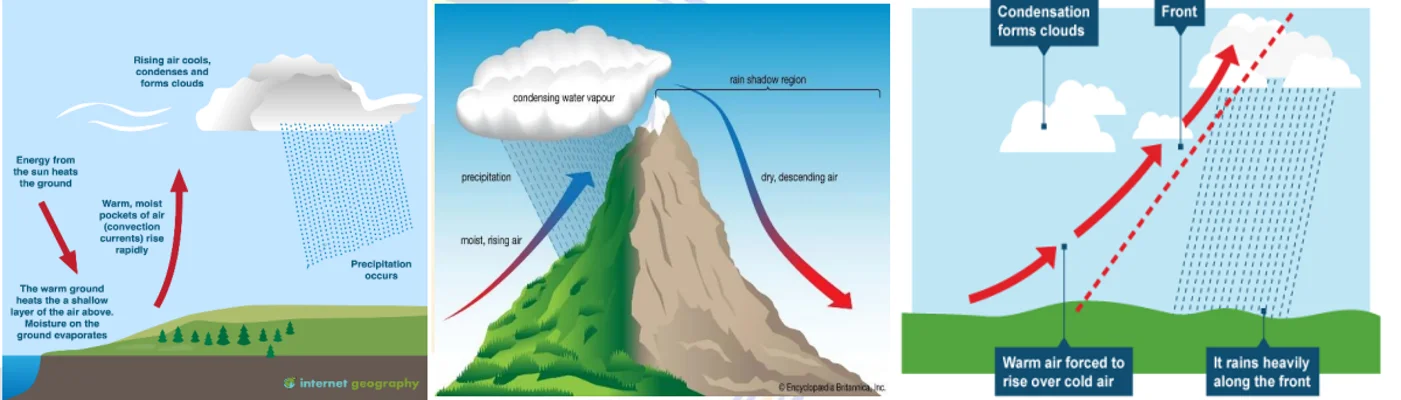
Rainfall occurs when condensed water droplets become too heavy to remain suspended in the atmosphere and fall to Earth. Depending on the mechanism of uplift, rainfall is classified as Convectional, Orographic, Frontal, and Cyclonic. Each type influences regional climates, agriculture, and ecosystems differently.
🌦 Definition of Rainfall
Rainfall is the process where condensed water vapor in the atmosphere falls to the Earth’s surface in the form of liquid (rain) or solid (snow, hail). The type and amount of rainfall depend on air temperature, humidity, wind patterns, and topography.
☀️ Convectional Rainfall
Cause: Intense heating of the Earth’s surface warms the air, making it rise rapidly.
Process: Rising air expands and cools adiabatically → condensation → formation of large cumulonimbus clouds.
Cloud Type: Cumulonimbus (towering thunderclouds).
Characteristics:
- Sudden, heavy downpour lasting a short time.
- Often accompanied by thunder, lightning, and gusty winds.
- Produces localized rainfall; may cause flash floods.
Occurrence: Common in equatorial regions (Amazon, Congo, Indonesia) and pre-monsoon India.
Example: Evening thunderstorms in tropical Africa and South Asia.
⛰ Orographic (Relief) Rainfall
Cause: Moist air is forced to rise over a mountain or highland barrier.
Process:
1. Air ascends on the windward side → cools → condensation → heavy rainfall.
2. Descending air on the leeward side becomes dry and warm, creating a rain shadow region.
Cloud Type: Nimbostratus and cumulonimbus.
Characteristics:
- Heavy and continuous rainfall on windward slopes.
- Dry conditions on leeward slopes.
Examples:
- Western Ghats (Karnataka, Kerala coast: heavy rain; Deccan Plateau: dry).
- Himalayas (Mawsynram in Meghalaya receives world’s heaviest rainfall).
Importance: Major water source for rivers and agriculture in mountainous regions.
🌦 Frontal (Cyclonic) Rainfall
Cause: Occurs when warm and cold air masses meet at a front (a boundary separating them).
Process: Warm air (lighter) rises over the dense cold air → cools → condensation → rain.
Cloud Type: Nimbostratus.
Types:
- Warm Front Rainfall: Gentle, continuous, long-lasting rainfall as warm air gradually rises over cold air.
- Cold Front Rainfall: Short, heavy rainfall as cold air pushes warm air upward quickly.
Occurrence: Common in temperate latitudes — UK, Western Europe, and North America.
Characteristics: Associated with mid-latitude cyclones and low-pressure systems.
🌧 Cyclonic / Monsoonal Rainfall
Cause: Associated with low-pressure systems or tropical cyclones that draw in moist air from oceans.
Process: Warm, moist air converges toward the center of the low-pressure system, rises, cools, and condenses to produce heavy rainfall.
Examples:
- Indian Summer Monsoon (June–September).
- Tropical cyclones in the Bay of Bengal and Arabian Sea.
Features: Seasonal, widespread, and highly beneficial for agriculture.
Importance: Main source of rainfall in South and Southeast Asia; determines cropping seasons.
💧 Special Types of Precipitation
1. Acid Rain
Formed when rainwater mixes with sulfur dioxide (SO₂) and nitrogen oxides (NOₓ) from industrial emissions and vehicles.
Effects: Damages forests, soils, aquatic life, and buildings.
Example: Industrial regions of Europe, North America, and India.
2. Virga
Rain that evaporates before reaching the ground due to dry air below the clouds.
Appears as wispy streaks beneath the cloud base.
Common in desert and semi-arid regions.
3. Snowfall and Hailstorms
Snowfall: Frozen precipitation formed directly by sublimation of vapor into ice crystals.
Hail: Hard ice pellets formed in cumulonimbus clouds due to strong updrafts.
Occurrence: Snow – polar/mountain regions; Hail – temperate and tropical thunderstorm zones.
🌍 Significance of Rainfall
Essential for maintaining the hydrological cycle and replenishing groundwater.
Determines agriculture, vegetation, and population distribution .
Influences climate zones and weather patterns globally.
Excessive rainfall causes floods ; deficiency leads to droughts .
| Type | Mechanism | Clouds | Examples |
|---|---|---|---|
| Convectional | Unequal heating, rising hot air | Cumulonimbus | Amazon, Congo, Pre-monsoon India |
| Orographic | Moist air forced up mountain slopes | Cumulus/Stratus | Western Ghats, Andes, Himalayas |
| Frontal | Warm and cold air masses meet | Nimbostratus | Europe, USA |
| Cyclonic | Low-pressure system uplift | Nimbostratus/Cumulonimbus | Indian Monsoon, Tropical cyclones |
Prelims tips
- Mawsynram (Meghalaya) has world’s highest rainfall due to orographic effect.
- Convectional rainfall = afternoon showers in equatorial regions.
- Frontal rainfall is common in temperate latitudes, linked to cyclones.
- Orographic rainfall creates rain-shadow zones (e.g., Deccan Plateau).
- Cyclonic rainfall forms due to monsoon and cyclonic depressions.
Mains points
- Rainfall is a key climatic factor affecting agriculture, ecosystems, and settlement.
- Convectional rainfall explains intense local storms in tropics.
- Orographic rainfall supports wet-windward vs dry-leeward contrasts (rain-shadow agriculture).
- Frontal rainfall linked to cyclones; crucial for temperate agriculture.
- Cyclonic rainfall explains India’s monsoons and food security.
- Special forms like acid rain highlight environmental issues linked to industrialization.
Global Distribution of Rainfall
Rainfall distribution across the globe varies greatly due to latitude, wind patterns, ocean currents, and relief. Regions of heavy rainfall are concentrated around the equator and coastal monsoon areas, while deserts and continental interiors receive very little precipitation.
🌧 Areas of Heavy Rainfall
Definition: Regions receiving more than 200 cm of rainfall annually.
Geographical Distribution:
- Equatorial Belt: Amazon Basin (South America), Congo Basin (Africa), Indonesia, Malaysia, and SE Asia.
- Monsoon Lands: Western coast of India, Bangladesh, Myanmar.
- Mountainous Regions: Windward slopes of the Western Ghats, Andes, and Himalayas.
Major Causes:
- Intense convectional activity near the equator.
- ITCZ (Intertropical Convergence Zone) bringing convergence of trade winds.
- Orographic uplift of moist air on mountain slopes.
- Seasonal monsoons carrying moisture-laden winds from oceans.
Characteristics:
- Daily rainfall (often in the afternoon).
- Evergreen vegetation and dense forests.
- Supports large rivers and fertile floodplains.
Examples: Mawsynram (India, world’s wettest place), Amazon Basin, Congo Basin, Indonesia.
☁️ Areas of Moderate Rainfall
Definition: Regions receiving 100–200 cm of rainfall annually.
Geographical Distribution:
- Warm temperate coastal zones: Eastern USA, Southern China, Mediterranean fringes.
- Regions adjoining heavy rainfall areas (edges of tropical rain zones).
Major Causes:
- Influence of Westerlies and monsoonal systems .
- Cyclonic rainfall in temperate latitudes.
Characteristics:
- Distinct wet and dry seasons.
- Deciduous forests and mixed farming zones.
- Moderate population density due to balanced climate.
Examples: Parts of China, eastern United States, Japan, and Mediterranean margins.
🌤 Areas of Low Rainfall
Definition: Regions receiving 50–100 cm of rainfall annually.
Geographical Distribution:
- Savanna regions: Central Africa (Sudan), interior Brazil, parts of Australia.
- Continental interiors: Central Asia, North American Prairies.
Major Causes:
- Distance from oceans (continentality).
- Weak monsoon influence.
- Seasonal rainfall during specific months only.
Characteristics:
- Long dry periods, short wet seasons.
- Grasslands and scrub vegetation.
- Suitable for pastoralism and limited agriculture.
Examples: Sudan, Brazilian Highlands, Central Asia, and Prairie regions of North America.
🏜 Areas of Scanty Rainfall
Definition: Regions receiving less than 50 cm of rainfall annually.
Geographical Distribution:
- Deserts: Sahara (Africa), Atacama (South America), Kalahari (Africa), Thar (India).
- Rain-shadow areas: Deccan Plateau (India), Patagonia (South America).
- Subtropical western coasts: Regions influenced by cold ocean currents.
Major Causes:
- Subtropical high-pressure belts preventing convection.
- Cold ocean currents (Peru, Benguela, California) that reduce evaporation and humidity.
- Orographic rain shadow behind mountain ranges.
Characteristics:
- Arid climate, clear skies, high diurnal temperature variation.
- Sparse vegetation and population.
Examples: Sahara, Atacama, Thar Desert, Deccan Plateau, Patagonia.
| Rainfall Zone | Annual Precipitation | Regions | Key Causes |
|---|---|---|---|
| Heavy Rainfall | >200 cm | Equatorial belt, Monsoon coasts, Windward slopes | ITCZ, convection, orographic uplift, monsoon |
| Moderate Rainfall | 100–200 cm | Warm temperate coasts, Mediterranean fringes | Westerlies, cyclones, monsoon spillover |
| Low Rainfall | 50–100 cm | Savannas, temperate interiors | Continentality, seasonal monsoon weakness |
| Scanty Rainfall | <50 cm | Deserts, rain-shadow areas, western subtropical coasts | High pressure belts, cold currents, rain-shadow |
Prelims tips
- Equatorial regions like Amazon Basin get >200 cm rainfall annually.
- Mawsynram (India) holds the world record for highest rainfall.
- Atacama Desert (Chile) is one of the driest regions on Earth (<1 cm/year).
- Orographic effect explains rainfall on Western Ghats vs rain-shadow in Deccan Plateau.
- Deserts on western continental margins are linked to cold ocean currents.
Mains points
- Rainfall distribution determines vegetation, agriculture, and settlement globally.
- Equatorial belt: heavy rainfall supports dense tropical rainforests.
- Monsoon regions: vital for agriculture and food security (South Asia).
- Savanna and steppe regions: moderate to low rainfall; support pastoralism.
- Deserts and rain-shadow zones: extreme scarcity affects human habitation.
- Global circulation, ocean currents, and relief explain spatial rainfall variations.
Indian & Physical Geography: All chapters
- The Universe and the Earth
- Atmosphere and Its Composition
- Atmospheric Temperature
- Atmospheric Moisture
- Air Mass, Fronts & Cyclones
- Evolution of Earth's Crust, Earthquakes and Volcanoes
- Interior of the Earth
- Landforms
- Geomorphic Processes
- Movement of Ocean Water
- Oceans and Their Properties
- Climate of a Region
- Indian Geography: Introduction and Geology
- Physiography of India
- Indian Climate
- Indian Drainage
- Soil and Natural Vegetation
- Mineral and Energy Resources, Industries in India
- Indian Agriculture
- Population, Migration and Urbanisation