
Indian & Physical Geography · UPSC Notes
Soil and Natural Vegetation — UPSC Geography Notes
Free, exam-focused notes for UPSC Prelims and Mains, with Prelims tips and Mains points for every topic. 13 topics.
Open in the interactive reader: bookmarks, progress tracking and read-aloud.
Soil: The Living Skin of the Earth
Soil is not just 'dirt' that gets your clothes dirty; it is a complex living ecosystem. It is the loose surface material covering Earth's crust, composed of minerals (45%), organic matter (5%), water (25%), and air (25%). It acts as a natural sponge, a carbon sink, and the foundation of all terrestrial life.
1. What exactly is Soil? (The Recipe)
Think of soil like a cake recipe. It creates the perfect environment for plants to grow. It needs four specific ingredients:
A. Inorganic Material (45%): This is basically broken-down rock. Over thousands of years, big rocks crumble into tiny pieces due to rain, wind, and sun. These tiny pieces are the 'bones' of the soil.
B. Organic Matter (5%): This is the 'life' of the soil. It includes:
Humus: Dark, rotting plants and dead animals. This acts like a vitamin pill for plants.
Living Organisms: Billions of bacteria, fungi, and earthworms that act like cooks, mixing the ingredients.
C. Water (25%) & Air (25%): Just like us, plant roots need to drink (water) and breathe (air). These fill the empty spaces between the soil particles.
2. Why is Soil so Important? (Significance)
1. The Carbon Bank: Soil stores more carbon than all the forests and the atmosphere combined! Healthy soil traps Carbon Dioxide (CO2) underground. If we destroy soil, this gas escapes and heats up the planet (Global Warming).
2. Natural Water Filter: When it rains, water passes through the soil layers. The soil acts like a sieve, trapping dust, chemicals, and pollutants. By the time water reaches the underground wells (aquifers), it is clean.
3. The Antibiotic Factory: Did you know that most of the medicines we use to kill bacteria (like Penicillin) originally came from tiny microbes living in the soil?
4. Food Security: 95% of our food comes directly or indirectly from soil. Without healthy soil, we cannot grow crops.
3. Physical Properties of Soil
A. Soil Texture (The Feel)
Texture simply means: How big are the particles? Imagine holding soil in your hand:
1. Sand (The Big Grains): These are large, coarse particles (like beach sand).
Problem: Water runs through it too fast (like a sieve). Plants get thirsty quickly.
2. Clay (The Tiny Dust): These are extremely fine, sticky particles.
Problem: It holds too much water and gets sticky like dough. When dry, it becomes hard like a brick. Air cannot get in, so roots suffocate.
3. Silt (The Middle Ground): Medium-sized particles. It feels smooth like flour.
4. Loam (The Perfect Mix): This is the farmer's best friend. It is a mix of Sand (40%), Silt (40%), and Clay (20%). It drains excess water but keeps enough moisture for plants.
B. Soil pH (The Taste)
This measures if the soil is Sour (Acidic) or Bitter (Alkaline).
The Scale: It ranges from 0 to 14. 7 is Neutral.
Ideal Range: Most crops love Neutral pH (6.5 - 7.5).
The Fix: If soil is too Acidic (sour), farmers add Lime (Chuna). If it is too Alkaline (salty/bitter), they add Gypsum.
| Property | Sand (Sandy Soil) | Clay (Clayey Soil) | Loam (Loamy Soil) |
|---|---|---|---|
| Particle Size | Large (Visible to eye) | Very Fine (Microscopic) | Mixed sizes |
| Water Holding | Very Low (Drains fast) | Very High (Waterlogging risk) | Moderate (Ideal) |
| Air Space (Aeration) | Excellent | Poor (Suffocates roots) | Good |
| Workability | Easy to plough | Hard/Sticky to plough | Easy to plough |
Prelims tips
- Pedogenesis: The scientific process of soil formation is called Pedogenesis.
- Edaphology vs. Pedology: Pedology is the study of soil in its natural environment. Edaphology is the study of soil in relation to living things (plants).
- Humus: Dark, organic material that forms in soil when plant and animal matter decays. It increases fertility.
- Soil Horizon: The vertical layering of soil (O, A, E, B, C, R layers). The top layer 'O' is rich in organic matter.
Mains points
- Soil Health Card Scheme: Discuss how this government initiative helps farmers correct soil nutrient imbalances (N-P-K ratio). It tells farmers exactly which fertilizer to use.
- Soil Pollution: Impact of excessive fertilizer (Urea) and pesticides causing biological death of soil (killing friendly bacteria).
- Carbon Sequestration: How 'Regenerative Agriculture' (farming without digging/tilling) can turn soil into a weapon against global warming by locking carbon inside.
Soil Structure, Porosity, and Moisture
Think of soil like a building. Soil Structure is how the bricks (particles) are arranged. Porosity is the empty space between them (windows/doors). Moisture is the water trapped inside. Only Capillary Water is useful for plants, while the rest is either too sticky or drains away.
1. Soil Structure (The Arrangement)
Soil particles (sand, silt, clay) don't just float around; they stick together to form clumps. These clumps are called Peds. The shape of these peds defines the structure.
Types of Structures:
Granular (Spherical): Small, round clumps. Like bread crumbs. Common in topsoil with grass. Great for farming.
Blocky: Large, square-like blocks. Common in subsoil.
Platy: Thin, flat horizontal layers (like a stack of plates). This usually happens when soil is compacted by heavy machinery or animals. It stops water from going down.
Columnar: Tall, vertical pillars. Common in arid (dry) soils.
2. Soil Porosity (The Empty Spaces)
Soil is not solid rock. It has holes called Pores. Porosity is the percentage of empty space in the soil.
Why does it matter? These pores act as the lungs and veins of the soil. They hold Air (for roots to breathe) and Water (for roots to drink).
Connection: High Porosity = Better water drainage and air circulation.
3. Soil Moisture (The Water Types)
Not all water in the soil is drinkable for plants. There are three types:
A. Gravitational Water (The Runaway):
This is the water that pours down freely due to gravity.
It goes deep into the groundwater table.
Plant Usage: Unavailable (It moves too fast and goes too deep).
B. Capillary Water (The Drinkable):
This water gets trapped in the small pores (capillaries) of the soil, fighting against gravity.
It stays there like water in a sponge.
Plant Usage: Available (This is the main source of water for plants).
C. Hygroscopic Water (The Sticky):
This is a very thin layer of water that sticks tightly to soil particles.
It is held by strong molecular forces.
Plant Usage: Unavailable (Roots are not strong enough to pull this sticky water off the soil particles).
| Type | Description |
|---|---|
| Granular | Formed by small spherical peds |
| Blocky | Formed by large angular peds |
| Platy | Thin, flat layers indicating compaction |
| Columnar | Tall, pillar-like structures in arid soils |
| Type | Description | Availability to Plants |
|---|---|---|
| Hygroscopic Water | Thin film on soil particles held by molecular forces | Unavailable |
| Capillary Water | Water in small pores, resists gravity | Available |
| Gravitational Water | Excess water drains downward by gravity | Generally Unavailable |
Prelims tips
- Wilting Point: This is the point where soil has NO Capillary water left. Only Hygroscopic water remains, which plants can't drink, so they wilt and die.
- Field Capacity: The maximum amount of water a soil can hold after the gravitational water has drained away.
- Loam Soil: It has the best structure for farming because it holds enough Capillary water but drains Gravitational water well.
- Compaction: Platy structure is bad for farming because it reduces porosity (roots can't breathe).
Mains points
- Soil Management: Discuss how 'Tillage' (ploughing) improves soil structure by breaking hard pans and increasing porosity.
- Irrigation Efficiency: Why Drip Irrigation is effective? Because it maintains 'Field Capacity' (keeping water in the Capillary zone) without causing waterlogging (Gravitational water).
- Clay Issues: Clay soil holds too much Hygroscopic water (unavailable) and causes waterlogging, making it difficult for crops that need aeration (like pulses).
Soil pH, Colour, and Profile (The Health Report of Soil)
Just like a doctor checks your temperature and blood report, a farmer checks the pH and Colour of the soil. pH tells if the soil is sour or bitter. Colour tells what minerals are inside. Profile is like cutting a cake to see the different layers inside.
1. Soil pH (The Acidity Meter)
Soil pH measures chemical nature. Think of it like a taste test for plants.
Acidic (Sour): Occurs in places with heavy rainfall (like Meghalaya). Rain washes away good minerals (Calcium, Magnesium), leaving acid behind.
Alkaline (Salty/Bitter): Occurs in dry places (like Rajasthan). Water evaporates, leaving white salts on top.
Neutral (Perfect): Most plants love a pH between 6 and 7.5. This is the 'Sweet Spot' where they can drink nutrients easily.
2. Soil Colour (The Identification Card)
The colour of the soil is a huge clue about what is inside it:
Black/Dark Brown: Rich in Humus (rotting plants). Very fertile (e.g., Black Cotton Soil).
Red/Yellow: Rich in Iron (Rust). Just like an iron nail rusts and turns orange/red, the iron in soil oxidizes. Common in South India.
White/Pale: Indicates Salt accumulation (in deserts) or severe Leaching (nutrients washed away in rainforests).
Grey/Blue: Indicates Waterlogging. Oxygen cannot reach the soil, turning iron into a greyish color.
3. Soil Profile (The Layer Cake)
If you dig a deep pit, you will see horizontal layers. These layers are called Horizons. Together, they make the Soil Profile.
O Horizon (Organic): The top carpet of leaves, grass, and dead bugs. Found in forests.
A Horizon (Topsoil): The most important layer for farmers. It is dark, soft, and full of roots and worms.
E Horizon (Eluviated/Leached): The 'Washed Out' layer. Water drips through here, taking clay and minerals down with it, leaving pale sand behind.
B Horizon (Subsoil): The 'Dump Yard'. The clay and minerals washed down from above get stuck here. It is hard and compact.
C Horizon (Parent Material): Broken pieces of the original rock.
R Horizon (Bedrock): The solid, unweathered rock at the bottom.
| Horizon | Name | What's inside? |
|---|---|---|
| O | Organic | Leaves, Humus (Forest floor) |
| A | Topsoil | Minerals + Humus (Best for crops) |
| E | Eluviated | Leached (Washed out) sand/silt |
| B | Subsoil | Clay & Iron deposits (Hard) |
| C | Parent Material | Broken Rocks |
Prelims tips
- Podzolization: A process in cool, humid climates where the 'E Horizon' becomes very distinct (ash-grey color) due to intense leaching.
- Gleying: In waterlogged soils (swamps), soil turns grey/blue due to lack of oxygen.
- pH Trick: High rainfall areas usually have Acidic soils. Low rainfall areas usually have Alkaline/Saline soils.
- Laterite Soil: Red in color due to iron, but poor in fertility because intense rain washes away the silica (leaching).
Mains points
- Soil Reclamation: Discuss how farmers use Lime to fix acidic soils (Kerala) and Gypsum to fix alkaline soils (Punjab/Haryana).
- Erosion Impact: When topsoil (A Horizon) erodes, the fertile land is lost forever, exposing the hard, infertile subsoil (B Horizon). This leads to desertification.
- Land Use Planning: Why we shouldn't build heavy factories on soils with a weak B-Horizon (poor load-bearing capacity).
Soil Development Processes (The Soil Factory)
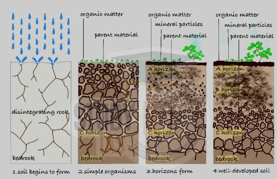
Soil formation is not a one-time event; it is a continuous process. Imagine soil as a factory where raw material (Rock/Regolith) undergoes four specific operations: Addition (Enrichment), Loss (Removal), Movement (Translocation), and Change (Transformation).
1. The Starting Point: Regolith
Before we have soil, we have Regolith. This is the layer of loose, broken rocks and dust that sits over the hard bedrock. Soil development processes act upon this Regolith to create true soil.
2. Process 1: Enrichment (Addition)
This is when new material is added to the soil.
Organic Enrichment: Leaves falling, animals dying, or manure being added to the topsoil.
Inorganic Enrichment: Wind blowing dust or rivers depositing silt (sediment) onto the land.
Result: This makes the soil darker and more fertile.
3. Process 2: Removal (Loss)
This is when material is taken away from the soil.
Surface Erosion: Wind or water washing away the top layer.
Leaching: Imagine pouring water over coffee grounds. The water takes the color and flavor down, leaving the grounds tasteless. Similarly, rain dissolves minerals (like calcium) and carries them deep underground, away from plant roots.
4. Process 3: Translocation (The Elevator)
This is the movement of materials inside the soil, either Up or Down. It creates distinct layers (Horizons).
Eluviation (The Exit): Movement OUT of a layer. Usually, water washes clay and minerals out of the upper layer (E-Horizon).
Illuviation (The Into): Movement INTO a layer. The clay washed out from above gets deposited into the lower layer (B-Horizon).
Calcification/Salinization: In dry areas, water evaporates and pulls salts UPWARDS to the surface.
5. Process 4: Transformation (The Chemical Change)
This is when materials change their form completely (like baking a cake).
Decomposition (Humification): Bacteria turn fresh leaves (organic matter) into a dark, sticky substance called Humus.
Weathering: Hard minerals (like Feldspar) chemically change into soft Clay.
Reddening: Iron minerals react with oxygen (rusting) to turn the soil red.
| Process | Action | Example |
|---|---|---|
| Enrichment | Input / Addition | Leaves falling and becoming compost (Humus). |
| Removal | Loss / Exit | Rain dissolving nutrients and taking them to groundwater (Leaching). |
| Translocation | Movement (Up/Down) | Clay moving from Topsoil (A) to Subsoil (B). |
| Transformation | Chemical Change | Hard rock turning into soft clay; Organic matter turning into Humus. |
Prelims tips
- E vs I Trick: Eluviation starts with E = Exit (Washing out). Illuviation starts with I = In (Washing in/Accumulation).
- Humification: This falls under Transformation because the chemical nature of the leaf changes to become soil.
- Leaching: This is a Removal process common in heavy rainfall areas (creating Laterite soil).
- Calcification: In deserts, calcium moves UPWARDS due to capillary action (Translocation).
Mains points
- Soil Fertility: Explain how 'Removal' (erosion/leaching) creates infertile soils like Laterite, while 'Enrichment' (alluvial deposits) creates fertile plains.
- Salinization: In irrigated drylands (like Punjab), the 'Translocation' of salts upwards destroys the soil. This is a man-made disaster.
- Climate Link: In Rainforests, decomposition (Transformation) is very fast, but Leaching (Removal) is also very fast. That's why rainforest soils are actually poor in nutrients.
Factors Influencing Soil Formation (Pedogenesis)
Soil formation is not magic; it is a scientific recipe. Geologists use the acronym CLORPT to remember the five key ingredients: Climate, Organisms, Relief, Parent Material, and Time. Without any one of these, soil cannot form properly.
1. Parent Material (The Genetics)
This is the raw material (rock) from which soil is born. Just as a child looks like their parents, the soil gets its colour and texture from the rock.
In-situ Soil: Formed directly on top of the parent rock (e.g., Black soil on Lava rock).
Transported Soil: Material brought by rivers or wind from somewhere else (e.g., Alluvial soil in Gangetic plains).
Example: Granite rock breaks down into Sandy soil; Basalt rock breaks down into Clayey soil.
2. Climate (The Active Chef)
This is the most powerful factor. It decides how fast soil forms.
Temperature: High heat speeds up chemical reactions. That's why soils form faster in tropical India than in cold Russia.
Rainfall (Leaching): Heavy rain washes nutrients (like lime) down into the lower layers. This is called Leaching.
3. Organisms / Biota (The Mixers)
Plants and animals turn dead rock into living soil.
Roots: They break rocks apart and hold the soil together to stop erosion.
Microbes: Bacteria and fungi act like decomposers, turning dead leaves into Humus (the dark, fertile stuff).
Earthworms: They are 'Nature's Plough'. They eat soil, mix it, and create holes for air to pass through.
4. Relief / Topography (The Shape of Land)
The slope of the land determines how deep the soil layer will be. This concept is often called a Soil Catena.
Steep Slope: Gravity pulls water and soil down. The soil layer is very Thin and infertile.
Valleys / Flat Land: Soil accumulates here. The layer is Thick and fertile.
5. Time (The Cooking Duration)
Soil is a non-renewable resource on a human timeline.
Young Soil: Soil that hasn't had enough time to form distinct layers (Horizons).
Mature Soil: Soil that has developed perfect layers over thousands of years.
Fact: It takes roughly 500 to 1000 years to form just 1 inch of topsoil!
6. Human Activities (The Disturbance)
Humans can destroy in days what nature took centuries to build.
Deforestation: Removing trees exposes soil to wind and rain, leading to erosion.
Over-irrigation: In dry areas (like Punjab), too much watering makes the soil salty (Salinization).
| Factor | Influence |
|---|---|
| Parent Material | Determines soil texture, colour, and chemistry |
| Climate | Rainfall causes leaching/salt buildup; temperature drives chemical processes |
| Organisms | Vegetation and soil fauna add organic matter and restructure soil |
| Relief | Slope gradient controls thickness of soil horizons |
| Time | Long-term process; ~500 years for 2.5 cm topsoil |
| Human Activities | Deforestation, farming alter soil fertility and erosion patterns |
Prelims tips
- Active vs Passive: Remember that Climate is an Active factor, while Parent Material is a Passive factor.
- Soil Catena: The sequence of different soil profiles down a slope (from hilltop to valley) is called a Catena.
- Podzolization vs Laterization: These are climate-driven processes. Podzolization happens in cool/humid climates; Laterization happens in hot/wet tropics.
- Nitrogen Fixation: Leguminous plants (like pulses) have bacteria (Rhizobium) in their roots that add Nitrogen to the soil.
Mains points
- Resource Management: Since soil takes 500+ years to form, it should be treated as a Non-Renewable Resource in policy making.
- Climate Change: Discuss how changing rainfall patterns (due to global warming) are altering soil chemistry (Leaching vs Salinity) in Indian agriculture.
- Sustainable Agriculture: Practices like 'Terrace Farming' on slopes help counter the 'Relief' factor by slowing down water and thickening the soil layer.
Major Soil Types (Expanded Details)
Soils are classified into three broad categories: Zonal (influenced by climate and vegetation), Intrazonal (dominated by local conditions like drainage and parent rock), and Azonal (young soils with little profile development). Each type plays a unique role in agriculture, ecosystems, and human livelihoods.
Zonal Soils – Climate & Vegetation Dominated
Tundra Soil: Found in Arctic climatic zones; frozen for most of the year (permafrost); organic matter decomposes slowly.
Podzol Soil: Acidic, ash-coloured, poor in nutrients; typical of coniferous forests in cool moist mid-latitudes.
Chernozem: Very fertile, dark black due to high humus; rich in phosphorus and ammonia; major grain-growing regions in Russia & Ukraine.
Chestnut Soil: Dark brown, formed under steppe grasses; less humus than chernozem but still fertile.
Brunizem (Prairie Soil): Rich humus, found in temperate grasslands; very good for wheat and maize cultivation.
Seirozem: Desert soil, light grey, poor organic content, alkaline in nature; requires irrigation for agriculture.
Latozols (Lateritic Soils): Develop in hot, humid climates; leached soils, poor fertility; used for crops like tea, coffee, cashew after fertilisation.
Intrazonal Soils – Local Factor Dominated
Saline Soils: Also called Reh, Kallar in India; high salt content makes them unsuitable for agriculture unless treated with gypsum/leaching.
Peat Soils: Waterlogged, organic-rich, found in bogs and marshes; act as important carbon sinks and fuel sources.
Calcareous Soils: Derived from limestone/dolomite parent rock; alkaline in nature; suitable for crops like cotton, maize, and pulses.
Azonal Soils – Young, Weakly Developed
Mountain/Scree Soils: Found on slopes; shallow, stony, prone to erosion; support alpine vegetation.
Alluvial Soils: Formed by river deposition; very fertile; stratified in nature (new alluvium = khadar, old alluvium = bhangar in India).
Glacial Soils: Poor in humus, composed of sand, gravel, boulders; found in higher latitudes and mountainous areas.
Loess Soils: Fine-grained, windblown deposits; highly fertile and easy to till; important in China’s wheat belt.
| Category | Soil Type | Properties | Regions |
|---|---|---|---|
| Zonal | Tundra | Frozen, poor organic matter | N. America, Eurasia |
| Zonal | Podzol | Ashy, acidic, poor agriculture | Cool mid-latitudes, coniferous forests |
| Zonal | Chernozem | Black, nutrient-rich, fertile | Russia, Ukraine, Canada, USA |
| Zonal | Chestnut | Dark brown, steppe grassland, humus-rich | Mongolia, China, USA |
| Zonal | Brunizem | Humus-rich, good for cereals | Prairie regions, USA, Europe |
| Zonal | Seirozem | Grey desert soil, poor humus | Turkmenistan, W. USA |
| Zonal | Latozols | Lateritic, red/yellow, iron-rich | Amazon, Brazil, SE Asia |
| Intrazonal | Saline | Salt-affected, alkaline | Arid/semi-arid regions |
| Intrazonal | Peat | Waterlogged, organic-rich | Cold, humid bogs/marshes |
| Intrazonal | Calcareous | CaCO3-rich, alkaline | Limestone regions |
| Azonal | Mountain/Scree | Rocky, shallow, erosion-prone | High mountains, moraines |
| Azonal | Alluvial | Fertile, stratified | Indo-Gangetic plain, Yangtze basin |
| Azonal | Glacial | Gravelly, poor humus | Glaciated regions |
| Azonal | Loess | Windblown silt, fertile | China, Great Plains, Europe |
Prelims tips
- Chernozem = 'Black Earth' → very fertile; major grain belt.
- Podzol = acidic, ash-like soil, poor for agriculture.
- Saline soils in India = Reh, Kallar.
- Alluvial soils = Khadar (new) and Bhangar (old).
- Loess soils = windblown, fertile, found in China’s wheat belt.
Mains points
- Zonal soils highlight the global climatic influence on pedogenesis (tundra → podzol → chernozem → laterite).
- Intrazonal soils demonstrate the importance of local geology (limestone → calcareous; evaporation → saline).
- Azonal soils are agriculturally significant due to their fertility (alluvial, loess).
- Soil types reflect ecosystem adaptations and agricultural suitability.
- Knowledge of soil classification is vital for global food security, crop selection, and sustainable land use.
Soils of India: Why Are They Different?
India has a variety of soils, from the Black Soil of Maharashtra to the Red Soil of Tamil Nadu. Why? Because soil is the child of its environment. It inherits characteristics from its parents (Rocks), is shaped by its home (Relief/Slope), and matures according to the weather (Climate).
1. Parent Material (The Genetics)
Just as you inherit eye color from your parents, soil inherits its color and texture from rocks.
Ancient Crystalline Rocks: Hard rocks like Granite and Gneiss (found in the South) contain iron. When they break down, they form Red Soil.
Deccan Trap Basalt: The volcanic lava rocks in Maharashtra and Gujarat break down to form Black Soil (Regur). It is black due to Titaniferous Magnetite.
Sedimentary Rocks: Rocks like Limestone in the Cuddapah and Vindhyan basins break down into Calcareous Soil (rich in lime).
2. Relief / Topography (The Shape of Land)
The slope of the land decides if soil stays or washes away.
Steep Slopes: In areas like the Chambal ravines or Himalayas, rain washes the topsoil away quickly. Result: Thin, infertile soil.
Flat Plains: In the Northern Plains (Ganga-Yamuna), rivers deposit layers of silt over thousands of years. Result: Very deep, fertile Alluvial Soil.
3. Climate (The Weathering Agent)
Climate is the most powerful factor. It decides the chemical nature of the soil.
Heavy Rain + Heat: In Kerala and Meghalaya, intense rain washes away silica and lime (Leaching), leaving behind iron and aluminum. This forms brick-like Laterite Soil.
Arid (Dry) Heat: In Rajasthan, lack of rain prevents humus formation. High evaporation leaves salts on top. Result: Sandy/Desert Soil.
4. Natural Vegetation (The Fertilizer)
Plants add 'life' to the soil.
Dense Forests: Trees drop leaves, which rot and turn into Humus. This makes the soil dark and fertile (e.g., Forest soils of Himalayas).
Scanty Vegetation: In deserts, there are no leaves to rot, so the soil has very low organic matter (Humus).
| Parent Rock | Soil Type | Key Characteristic |
|---|---|---|
| Granite / Gneiss | Red Soil | Red due to Iron Oxide (Rust) |
| Basalt (Lava) | Black Soil | Moisture retentive (Self-ploughing) |
| Sandstone | Sandy Soil | Porous, low water holding |
| Laterite Rock | Laterite Soil | Leached, acidic, good for bricks |
Prelims tips
- Regur: Another name for Black Soil. It comes from the Telugu word 'Reguda'.
- Self-Ploughing: Black soil swells when wet and cracks when dry. This natural aeration is called self-ploughing.
- Karewas: Special lacustrine (lake-deposited) soils found in Kashmir, famous for Saffron (Zafran) cultivation.
- Khaddar vs Bhangar: Khaddar is new, fertile alluvial soil (near rivers). Bhangar is old, less fertile alluvial soil (away from rivers).
Mains points
- Soil Erosion: Explain how 'Relief' plays a villain in the Chambal region, creating badlands (ravines) unsuitable for agriculture.
- Crop Planning: Why do we grow Cotton in Maharashtra (Black Soil) but Tea in Kerala/Assam (Laterite/Acidic Soil)? Connect soil properties to crop needs.
- Salinization: How mismanagement of canal irrigation in arid regions (like Indira Gandhi Canal in Rajasthan) is turning sandy soil into saline wastelands.
Types of Soil in India
India has diverse soil types shaped by geology, relief, climate, and vegetation. The major soil types include Alluvial, Black, Red & Yellow, Laterite, Forest-Mountain, Arid, Saline-Alkaline, and Peaty soils. These soils vary in fertility, texture, mineral content, and crop suitability, making them critical for India’s agriculture and economy.
| Soil Type | Distribution | Formation | Characteristics | Significance |
|---|---|---|---|---|
| Alluvial Soil | Covers ~40% of India; Indo-Gangetic-Brahmaputra plains, river valleys | Formed by deposition of sand, silt, clay by rivers | Khadar (new alluvium), Bhangar (old alluvium); sandy loam to clayey; rich in potash, poor in phosphorus; light grey to ash grey | Most fertile; crops: wheat, rice, jute, oilseeds, tobacco |
| Black Soil (Regur) | Madhya Pradesh, Maharashtra, Andhra Pradesh, Gujarat, Tamil Nadu | Weathering of basalt (Deccan Trap), also gneiss and schist | Clayey, deep, impermeable; rich in lime, alumina, iron, magnesium; poor in nitrogen & humus; deep black to grey; cracks in dry season (self-ploughing) | Best for cotton; also wheat, millets, tobacco, sunflower, castor |
| Red & Yellow Soil | Jharkhand, Odisha, Andhra Pradesh, Telangana, Chhattisgarh, Madhya Pradesh, Karnataka, Tamil Nadu (west) | Weathering of crystalline and metamorphic rocks | Red (iron oxides), yellow (hydrated); uplands → thin, sandy, porous; lowlands → thick, fertile; poor in nitrogen, lime, humus; rich in potash | Millets (upland); cotton, wheat, pulses, potatoes, tobacco (lowland) |
| Laterite Soil | Karnataka, Tamil Nadu, Kerala, Assam, Odisha (hills), Madhya Pradesh | Intense leaching in high rainfall & temperature areas | Poor in humus, nitrogen, calcium; rich in iron, aluminium oxides; acidic | Cashew, tea, coffee, rubber, spices; also used for brick making |
| Forest-Mountain Soil | Himalayas, Western & Eastern Ghats, hill slopes & valleys | Deposition of organic matter from forests | Loamy & silty in valleys; coarse on slopes; rich in humus, poor in lime & phosphorus | Tea, coffee, fruits, spices (peninsular); wheat, barley, maize (Himalayas) |
| Arid/Desert Soil | Western Rajasthan (Thar), Punjab, Haryana (low rainfall areas) | Aeolian sand from Indus basin via monsoon winds | Sandy, saline, poor in humus; red-brown; calcareous layer restricts infiltration; high in phosphate | Millets, pulses (drought-resistant); reclaimable via irrigation |
| Saline-Alkaline Soil | Arid/semi-arid areas; western Gujarat, Haryana, Punjab, eastern deltas, Sundarbans | Over-irrigation, saltwater intrusion | High in sodium, potassium, magnesium; infertile; poor in nitrogen & calcium | Legumes, paddy (with treatment); generally less productive |
| Peaty Soil | Southern Uttarakhand, North Bihar, West Bengal, Odisha, Tamil Nadu (coastal) | High rainfall & humidity → high vegetative growth | Black, heavy; rich in humus & organic matter; poor in potash & phosphorus; acidic | Rice and jute cultivation |
Prelims tips
- Alluvial = Khadar (new) & Bhangar (old).
- Black soil = self-ploughing; ideal for cotton.
- Red colour due to iron oxides; turns yellow when hydrated.
- Laterite soil = poor fertility, rich in Fe & Al; used for cashew, bricks.
- Desert soil = sandy, saline, high phosphate; reclaimed via irrigation.
- Peaty soil = humus rich, acidic, found in Bihar & Bengal.
- Soil erosion types: sheet erosion (uniform removal of the top layer), rill erosion (small channels), gully erosion (deep ravines, e.g. Chambal) and wind erosion (arid Rajasthan).
Mains points
- Alluvial soils are agriculturally most important, sustaining India's food grains production.
- Black soils are crucial for cotton production, supporting India's textile economy.
- Red & Yellow soils highlight climatic control (tropical to semi-arid regions).
- Laterite soils are less fertile but support plantation crops and brick industry.
- Forest soils show how vegetation influences humus-rich soils in hilly areas.
- Desert soils illustrate arid adaptation; reclamation via irrigation demonstrates human impact.
- Saline-alkaline soils highlight issues of over-irrigation and groundwater salinity.
- Peaty soils act as natural carbon sinks and support rice-jute economy in humid regions.
Natural Vegetation of India
Natural vegetation refers to plant communities that grow naturally without human interference. India’s vegetation is highly diverse due to its varied climate, soil, altitude, and rainfall. The distribution ranges from evergreen forests in high rainfall areas to thorn forests in arid regions, and includes unique mangroves in coastal deltas.
Factors Influencing Natural Vegetation
Land and Soil: Natural vegetation mainly occurs on non-agricultural lands. Soil type influences vegetation – e.g., arid soils support cacti and thorn bushes, fertile alluvial soils support dense forests.
Temperature & Humidity: Dictate vegetation characteristics. Tropical evergreen forests in humid Terai areas, montane forests (rhododendrons, junipers) at higher altitudes.
Photoperiod (Sunlight): Duration of sunlight varies with latitude, altitude, and season. Longer photoperiod → faster growth (e.g., summer).
Altitude: Vegetation decreases with altitude. Sun-facing slopes support denser growth than shaded slopes.
Spatial Distribution
High Rainfall Areas (>200 cm): Western Ghats, North-East India, Andaman & Nicobar → Tropical Evergreen forests. No fixed shedding season; year-round growth.
Moderate Rainfall Areas (70–200 cm): Central India, Himalayan foothills → Tropical Deciduous forests (sal, teak). Trees shed leaves in dry season to conserve water.
Low Rainfall/Semi-arid (<70 cm): Rajasthan, Gujarat, Deccan plateau → Thorn & scrub forests; xerophytic plants adapted to dry, coarse soils.
Coastal/Delta Regions: Sundarbans, Godavari, Mahanadi deltas → Mangrove forests; adapted to saline & freshwater mix.
| Rainfall Zone | Vegetation Type | Regions | Key Features |
|---|---|---|---|
| >200 cm | Tropical Evergreen Forests | Western Ghats, NE India, Andaman & Nicobar | Year-round green, no leaf-shedding season |
| 70–200 cm | Tropical Deciduous Forests | Central India, Himalayan foothills | Leaves shed in summer; teak & sal dominant |
| <70 cm | Thorn & Scrub Forests | Rajasthan, Gujarat, Deccan Plateau | Cacti, thorny bushes, drought-adapted plants |
| Coastal/Delta | Mangroves | Sundarbans, Godavari, Mahanadi deltas | Saline-tolerant vegetation (e.g., Sundari tree) |
Prelims tips
- Khadar-Bhangar distinction is important for Alluvial soils, but in vegetation context → rainfall zones matter.
- Evergreen forests = >200 cm rainfall, no definite leaf-shedding.
- Deciduous forests = 70–200 cm rainfall, teak & sal important.
- Thorn forests = <70 cm rainfall, xerophytic plants.
- Mangroves = saline environment, Sundari tree (Sundarbans).
Mains points
- Natural vegetation in India reflects rainfall gradients and altitude differences.
- Evergreen forests in high rainfall zones conserve biodiversity and regulate monsoon.
- Deciduous forests cover maximum area and provide timber resources (teak, sal).
- Thorn forests highlight adaptations to arid climates, sustaining pastoral economy.
- Mangroves act as natural coastal shields against cyclones and tsunamis.
- Conservation challenges include deforestation, urbanization, and climate change.
Classification of Natural Vegetation in India
India is a land of great variety. Because rainfall and temperature vary from Kashmir to Kanyakumari, our forests vary too. We classify them into five major types based on Climate (mainly rainfall). From the dense Evergreen forests that never turn brown, to the Thorny bushes of the desert, each has a unique ecosystem.
Major Types of Vegetation
Think of vegetation as a mirror of rainfall. Where rain is heavy, forests are dense. Where rain is low, forests are sparse.
1. Tropical Evergreen Forests (The Rain Lovers)
2. Tropical Deciduous Forests (The Monsoon Forests)
3. Tropical Thorn Forests and Scrubs (The Desert Warriors)
4. Montane Forests (The Mountain Dwellers)
5. Mangrove Forests (The Coastal Guards)
1. Tropical Evergreen Forests
Why 'Evergreen'? Do these trees never shed leaves? No. They do shed leaves, but not all at the same time. Different species shed leaves at different times, so the forest always looks green.
Climate Requirements: Heavy rainfall (>200 cm) and short dry season. Hot and humid all year round.
Structure (Stratification): These forests look like a multi-storied building. High trees (60m+) at the top, followed by smaller trees, shrubs, and creepers at the bottom. The canopy is so thick that sunlight hardly reaches the ground.
Distribution: Western slopes of Western Ghats (Kerala/Karnataka), Lakshadweep, Andaman & Nicobar, and Upper Assam.
Flora (Trees): Hardwood trees like Ebony, Mahogany, Rosewood, Rubber, and Cinchona.
Fauna (Animals): Elephants, Monkeys, Lemurs. The One-horned Rhinoceros is found in the jungles of Assam and West Bengal.
2. Tropical Deciduous Forests
The Monsoon Connection: These are the most widespread forests in India. They depend heavily on the Monsoons.
Why 'Deciduous'? To survive the dry summer, these trees shed their leaves for about 6-8 weeks. This stops water loss through transpiration.
Classification: They are divided into two based on water availability:
Moist Deciduous (100-200 cm rain): Found in NE States, Foothills of Himalayas, Jharkhand, Odisha. (Main Tree: Teak).
Dry Deciduous (70-100 cm rain): Found in peninsular plateau, Bihar, UP. (Main Trees: Teak, Sal, Peepal, Neem).
Economic Value: These forests are commercially the most important (Timber, Sandalwood).
Fauna: Lion, Tiger, Pig, Deer, and Elephant.
| Feature | Evergreen Forests | Deciduous Forests |
|---|---|---|
| Rainfall | High (>200 cm) | Moderate (70–200 cm) |
| Appearance | Green all year round | Brown/Leafless in Summer |
| Density | Very Dense (Impenetrable) | Less Dense (Park-like) |
| Wood Type | Hardwood (Difficult to cut/transport) | Valuable Timber (Teak/Sal) |
| Key Locations | Western Ghats, Andaman, North East | MP, UP, Bihar, Odisha |
Prelims tips
- Teak (Sagwan) is the most dominant species of Tropical Deciduous forests.
- Shola Forests: These are temperate forests found in the Nilgiris, Anaimalai, and Palani hills (South India) inside Evergreen areas.
- Sandalwood: It grows in Dry Deciduous forests (Karnataka/Andhra).
- Commercial Use: It is easier to exploit Deciduous forests than Evergreen forests because Evergreen forests are too dense and have mixed species.
Mains points
- Biodiversity vs Economy: Evergreen forests are biodiversity hotspots (genetic pool) but are hard to log commercially. Deciduous forests are the backbone of India's timber industry.
- Human Impact: Deciduous forests have faced the most destruction because they are located in fertile plains (UP, Bihar) suitable for agriculture.
- Conservation: Discuss the importance of 'Sacred Groves' in protecting rare species in these forests.
Tropical Thorn Forests and Montane Forests of India
Tropical thorn forests occur in arid and semi-arid regions with less than 70 cm rainfall, while montane forests appear in high-altitude areas, forming successive vegetation belts from tropical to tundra types. Both vegetation zones showcase adaptations to extreme climates and support unique biodiversity.
Tropical Thorn Forests and Scrubs
Distribution: Areas with <70 cm rainfall; NW India, Gujarat, Rajasthan, MP, Chhattisgarh, UP, Haryana.
Vegetation: Thorny trees, bushes, scattered distribution, deep roots. Stems succulent for water storage; small, thick leaves to minimize evaporation.
Tree Species: Acacias, palms, euphorbias, cacti.
Fauna: Rats, mice, rabbits, foxes, wolves, tigers, lions, wild asses, horses, camels.
Montane Forests
Vegetation Zonation: Vegetation changes with altitude (similar to tropical → tundra transition).
Wet Temperate Forests (1000–2000 m): Evergreen broadleaf trees like oaks, chestnuts.
Coniferous Forests (1500–3000 m): Pine, deodar, silver fir, spruce, cedar; mainly southern Himalayas, NE highlands.
Alpine Vegetation (>3600 m): Silver fir, junipers, birches; stunted near snow-line; alpine grasslands used for grazing by Gujjars & Bakarwals.
Tundra Vegetation: At highest altitudes; mosses, lichens dominate.
Fauna: Kashmir stag, spotted deer, wild sheep, jackrabbit, Tibetan antelope, yak, snow leopard, ibex, bears, red panda, thick-haired sheep & goats.
| Feature | Tropical Thorn Forests | Montane Forests |
|---|---|---|
| Rainfall | <70 cm | Varies by altitude |
| Distribution | NW India, Gujarat, Rajasthan, MP | Himalayas, NE hills, southern highlands |
| Vegetation | Acacias, palms, euphorbia, cactus | Oaks, chestnut, pine, deodar, fir, spruce |
| Adaptations | Succulent stems, small leaves | Altitude-based zonation (tropical → tundra) |
| Fauna | Camels, wild asses, lions, foxes | Snow leopard, yak, red panda, ibex |
Prelims tips
- Thorn forests = <70 cm rainfall, xerophytic plants (acacia, cactus).
- Montane forests show altitude-based succession: temperate → alpine → tundra.
- Yak, snow leopard, red panda = Montane fauna.
- Camels, wild asses = Thorn forest fauna.
Mains points
- Thorn forests represent xerophytic adaptations, important for survival in semi-arid India.
- Montane forests provide ecosystem services like water regulation, carbon sequestration, and biodiversity support.
- Altitude-based vegetation zones in Himalayas are comparable to latitudinal vegetation from tropics to poles.
- Nomadic pastoralists like Gujjars & Bakarwals depend on alpine grasslands for grazing.
- Both forest types face threats: desertification in thorn regions, deforestation and climate change in montane areas.
Mangrove Forests and Medicinal Plants of India
Mangroves are special forests that live in salty water where rivers meet the sea. They act as a shield against cyclones. India is also known as the 'Botanical Garden of the World' because of its vast collection of medicinal plants used in Ayurveda to cure diseases naturally.
1. Mangrove Forests (The Coastal Guards)
What are they? Most trees die in salty water, but Mangroves thrive in it. They are found in Deltas (where rivers dump mud into the sea).
Special Features:
Breathing Roots (Pneumatophores): Their roots grow upwards out of the mud to breathe air, because the muddy soil has no oxygen.
Tangled Roots: Their roots look like a messy net. This holds the soil together and stops coastal erosion.
Distribution in India:
West Bengal: The Sundarbans (Ganga-Brahmaputra Delta) is the largest mangrove forest in the world.
Odisha & Andhra: Mahanadi, Godavari, and Krishna deltas.
Key Tree: The Sundari tree provides hard, durable timber (used for making boats).
Wildlife: Famous for the Royal Bengal Tiger (the only tigers in the world that swim in salty water), crocodiles, and turtles.
2. Medicinal Plants (The Green Pharmacy)
India has a rich history of using plants as medicine (Ayurveda). Out of 2,000 recorded plants, about 500 are used regularly.
Key Plants & Uses:
Sarpagandha: Used to treat High Blood Pressure. (Note: It is found only in India).
Neem: The 'Village Pharmacy'. It kills bacteria and cures skin diseases.
Tulsi: The Holy Basil. Used for cough, cold, and boosting immunity.
Jamun: Its seeds are crushed into powder to control Diabetes.
Arjun: The juice of leaves is good for earaches and regulating blood pressure.
Babool: Its gum is used as a tonic, and leaves cure eye sores.
| Plant Name | Primary Cure/Use |
|---|---|
| Sarpagandha | Blood Pressure (Endemic to India) |
| Jamun | Diabetes (Seed powder), Digestion |
| Arjun | Blood Pressure, Earache |
| Neem | Antibiotic, Skin infection |
| Tulsi | Cough, Cold, Immunity |
| Kachnar | Asthma, Ulcers |
Prelims tips
- Unique to India: Sarpagandha is the only medicinal plant listed in NCERT as being found only in India.
- Breathing Roots: The technical term for mangrove roots that grow upwards is Pneumatophores.
- World Record: The Sundarbans is the largest single block of tidal halophytic mangroves in the world.
- Vivipary: Mangrove seeds germinate (start growing) while still attached to the parent tree, so they don't drown in the water when they fall.
Mains points
- Disaster Management: Explain the role of Mangroves as a 'Bio-Shield'. They reduced the impact of the 2004 Tsunami and several cyclones in Odisha/West Bengal.
- Blue Economy: Mangroves are breeding grounds for fish and crabs, supporting the livelihoods of fishermen.
- Traditional Knowledge: The importance of documenting tribal knowledge of medicinal plants before it is lost or patent-pirated (Biopiracy).
Status of Forest Cover in India (ISFR 2021)
According to the India State of Forest Report (ISFR) 2021, the total forest and tree cover of India is 24.62% of its geographical area. Madhya Pradesh has the largest forest cover, followed by Arunachal Pradesh, Chhattisgarh, Odisha, and Maharashtra. Forest cover at the national level increased by 1,540 sq km, with notable gains in Andhra Pradesh, Telangana, Odisha, Karnataka, and Jharkhand.
Key Findings of ISFR 2021
Total Forest & Tree Cover: 24.62% of India’s geographical area.
Top States by Forest Cover: Madhya Pradesh > Arunachal Pradesh > Chhattisgarh > Odisha > Maharashtra.
Increase in Cover: National forest cover increased by 1,540 sq km.
States with Maximum Gain: Andhra Pradesh, Telangana, Odisha, Karnataka, Jharkhand.
Tree Cover Growth: Increased from 90,844 sq km (2011) → 95,748 sq km (2021); decadal growth of 4,904 sq km.
Special Chapter: Assessment of forest cover in tiger reserves, corridors, and decadal change included in ISFR 2021.
Forest Survey of India (FSI): Conducts biennial assessment; under Ministry of Environment, Forest and Climate Change (MoEFCC).
| Aspect | Details |
|---|---|
| Total Forest & Tree Cover | 24.62% of geographical area |
| Top State (Forest Cover) | Madhya Pradesh |
| Other Major States | Arunachal Pradesh, Chhattisgarh, Odisha, Maharashtra |
| Increase in Forest Cover | 1,540 sq km |
| Tree Cover Growth (2011–2021) | 90,844 → 95,748 sq km (4,904 sq km increase) |
| Special Inclusion | Assessment of Tiger reserves, corridors, decadal change |
| Agency | Forest Survey of India (FSI), under MoEFCC |
Prelims tips
- India’s forest & tree cover = 24.62% (ISFR 2021).
- Madhya Pradesh has maximum forest cover.
- 1,540 sq km increase recorded at national level.
- Tree cover increased by 4,904 sq km in a decade.
- FSI conducts biennial forest assessments under MoEFCC.
Mains points
- India’s forest cover shows steady improvement but still below the 33% target under National Forest Policy.
- Increase in Andhra Pradesh, Telangana, Odisha, Karnataka, and Jharkhand reflects effective afforestation drives.
- Challenges remain: deforestation, mining, urbanization, and climate change.
- Special assessment in tiger reserves highlights ecological importance of protected areas.
- Strengthening community forestry, afforestation, and policy enforcement is essential for sustainable forest management.
Indian & Physical Geography: All chapters
- The Universe and the Earth
- Atmosphere and Its Composition
- Atmospheric Temperature
- Atmospheric Moisture
- Air Mass, Fronts & Cyclones
- Evolution of Earth's Crust, Earthquakes and Volcanoes
- Interior of the Earth
- Landforms
- Geomorphic Processes
- Movement of Ocean Water
- Oceans and Their Properties
- Climate of a Region
- Indian Geography: Introduction and Geology
- Physiography of India
- Indian Climate
- Indian Drainage
- Soil and Natural Vegetation
- Mineral and Energy Resources, Industries in India
- Indian Agriculture
- Population, Migration and Urbanisation