
Geography Optional · UPSC Notes
The Earth's Interior and Tectonics — UPSC Geography Optional Notes
Free, exam-focused notes for UPSC Prelims and Mains, with Prelims tips and Mains points for every topic. 5 topics.
Open in the interactive reader: bookmarks, progress tracking and read-aloud.
Earth's Interior, Origin of the Crust and Geomagnetism
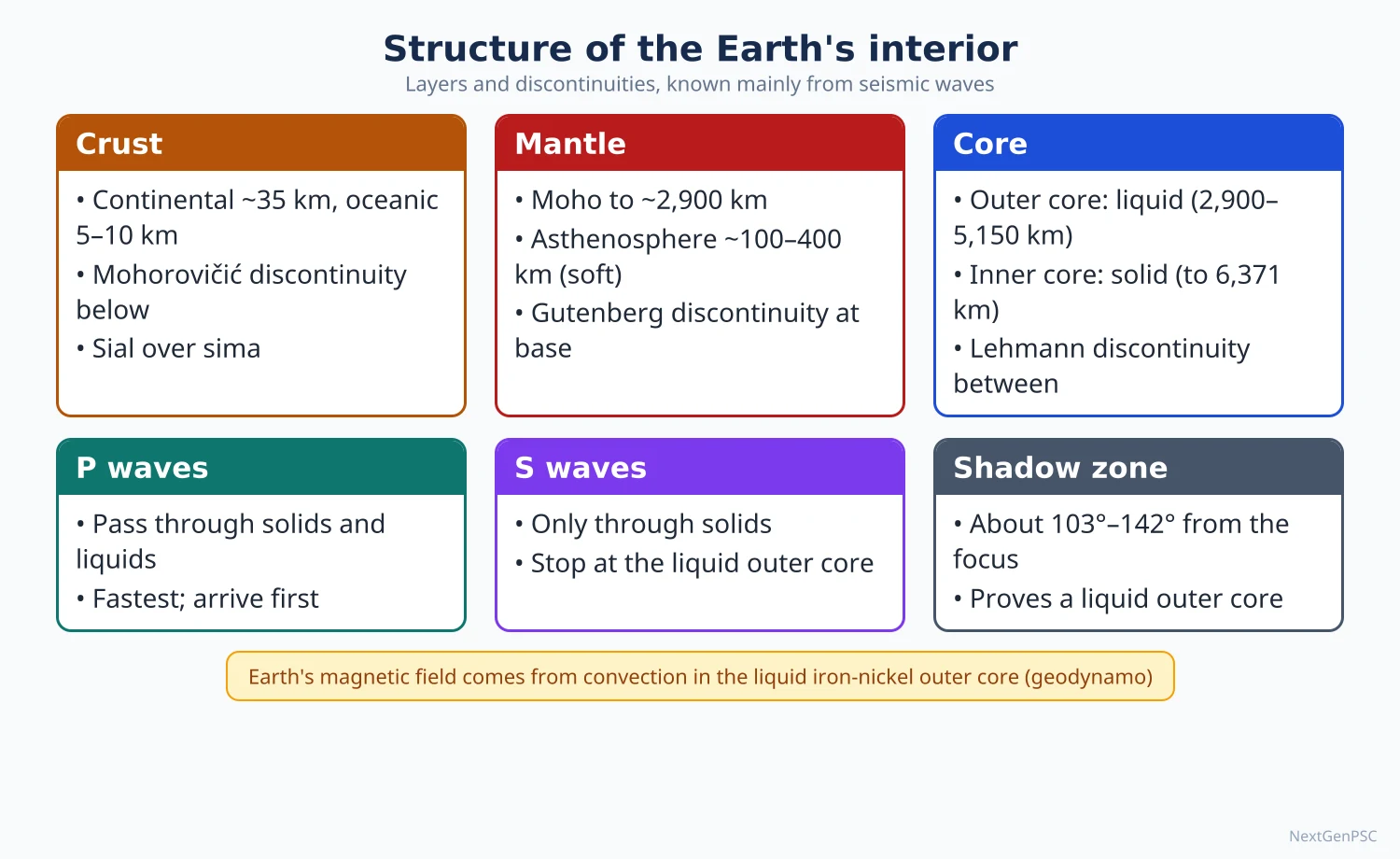
Seismic waves show that the earth is layered into crust, mantle, outer core and inner core, separated by the Moho, Gutenberg and Lehmann discontinuities. Temperature, pressure and density rise with depth, and the liquid iron-nickel outer core generates the geomagnetic field through a geodynamo. Rocks record past fields (palaeomagnetism), which later became key evidence for continental drift and sea-floor spreading.
In simple words
Nobody has drilled even 13 km into the earth, yet we know its inside is made of layers, mainly from how earthquake waves travel.
It is like tapping a watermelon to guess its inside: the sound changes where the inside changes.
The hot, moving liquid metal deep inside makes the earth a giant magnet, which guides compasses and shields life from solar wind.
UPSC asks how we know the interior, what the discontinuities are, and how magnetism in rocks proves that continents move.
1. Sources of knowledge about the interior
Direct sources: mines and boreholes reach only a few kilometres; the deepest, the Kola Superdeep Borehole in Russia, reached about 12.3 km (1989), less than 0.2% of the earth's radius of about 6,371 km.
Volcanic material: lava and xenoliths (fragments of deep rock carried up) give samples of the upper mantle, for example kimberlite pipes that bring up diamonds.
Seismic waves (main indirect source): P-waves (primary, compressional) pass through solids and liquids; S-waves (secondary, shear) pass only through solids; both bend (refract) and reflect where density changes.
Shadow zones: S-waves are not recorded beyond about 104° from the epicentre, and P-waves are weak or absent between about 104° and 140°, which shows a liquid outer core that stops S-waves and bends P-waves.
Other indirect evidence: meteorites (similar in composition to the earth, iron meteorites suggest an iron core), gravity anomalies, the mean density of the earth (about 5.5 g/cm³, far higher than surface rocks of about 2.7–3.0 g/cm³) and the magnetic field.
2. Layers and discontinuities
Crust: the thin outer shell; oceanic crust is about 5–10 km thick and basaltic, continental crust averages about 35–40 km and reaches about 70 km under the Himalaya and Tibet.
Conrad discontinuity: in some continental areas, a boundary between the upper granitic and lower basaltic crust; it is not found everywhere.
Mohorovičić (Moho) discontinuity: identified by Andrija Mohorovičić in 1909 from the Croatian earthquake records; the base of the crust where P-wave speed jumps to about 8 km/s.
Mantle: from the Moho to about 2,900 km, making up about 84% of the earth's volume; peridotite-like rock rich in iron and magnesium silicates.
Asthenosphere: a weak, partly molten zone in the upper mantle at roughly 100–250 km depth, also called the low-velocity zone; the rigid lithosphere (crust plus uppermost mantle) moves over it.
Mantle transition zone: at about 410–660 km, minerals change to denser forms; some Indian textbooks call the upper-lower mantle boundary the Repetti discontinuity.
Gutenberg discontinuity: at about 2,900 km, the core-mantle boundary, named after Beno Gutenberg (1913–14), where S-waves vanish.
Outer core: about 2,900–5,150 km, liquid iron-nickel with some lighter elements.
Lehmann discontinuity: at about 5,150 km, discovered by the Danish seismologist Inge Lehmann in 1936 from faint P-waves in the shadow zone; it marks the solid inner core.
Inner core: about 5,150–6,371 km, solid iron-nickel, solid despite very high temperature because of enormous pressure.
Older chemical classification: Eduard Suess named SIAL (silica-alumina, continental crust), SIMA (silica-magnesium, oceanic crust and below) and NIFE (nickel-iron, core).
3. Physical conditions of the interior
Temperature: rises at roughly 25–30 °C per km in the upper crust (the geothermal gradient), but the rate falls with depth; the core is estimated at about 5,000–6,000 °C.
Sources of heat: radioactive decay of uranium, thorium and potassium, residual heat from the earth's formation, and heat released as the inner core crystallises.
Pressure: increases with the weight of overlying rock and reaches about 3.6 million times atmospheric pressure at the centre.
Density: rises from about 2.7 g/cm³ in the crust to about 3.3–5.5 in the mantle and about 10–13 in the core.
State of matter: solid crust and mostly solid mantle that flows slowly over geological time (plastic behaviour), liquid outer core, solid inner core.
4. Origin and evolution of the crust
Formation of the earth: about 4.54 billion years ago by accretion of planetesimals in the solar nebula; heat from impacts and radioactivity melted the young earth.
Differentiation: heavy iron sank to form the core and lighter silicates rose to form the mantle and crust, a process sometimes called the iron catastrophe.
Earliest crust: the oldest known mineral grains are zircons from the Jack Hills of Western Australia, about 4.4 billion years old; among the oldest rocks is the Acasta Gneiss of Canada, about 4.0 billion years.
Continental crust: formed by repeated partial melting of the mantle and of older crust at subduction zones; it is light, thick and old, so it is rarely destroyed.
Oceanic crust: created at mid-ocean ridges and destroyed at trenches, so the oldest surviving ocean floor, in the western Pacific, is only about 180–200 million years old.
Growth of continents (debated): some geologists argue most continental crust formed early in earth history; others argue it grew gradually through time.
Indian example: the Dharwar, Singhbhum, Bastar and Aravalli cratons form the ancient core of Peninsular India, with some rocks of the Singhbhum craton about 3.3–3.5 billion years old.
5. Endogenetic and exogenetic forces
Endogenetic forces: come from within the earth (internal heat); they build relief through diastrophism (folding, faulting, epeirogeny, orogeny), volcanism and earthquakes.
Exogenetic forces: come from the sun's energy and gravity; they wear relief down through weathering, mass movement, erosion and deposition by rivers, glaciers, wind, waves and groundwater.
Landform development: each landform is the result of the contest between these two sets of forces acting on a given rock structure over time, an idea W.M. Davis summed up as structure, process and stage.
6. Geomagnetism
Nature of the field: roughly a dipole, like a bar magnet tilted about 10° from the rotation axis; its strength at the surface is about 25–65 microtesla.
Geodynamo: convection of the electrically conducting liquid outer core, organised by the earth's rotation, sustains the field; this self-exciting dynamo theory was developed by Walter Elsasser and Edward Bullard in the 1940s–50s.
Elements: declination (angle between magnetic and true north), inclination or dip (angle of the field with the horizontal, 0° at the magnetic equator and 90° at the magnetic poles) and intensity.
Secular variation: the magnetic poles wander; the north magnetic pole has moved from Arctic Canada towards Siberia in recent decades.
Reversals: the field flips polarity at irregular intervals; the last full reversal, the Brunhes-Matuyama reversal, was about 780,000 years ago.
Magnetosphere: the field deflects the solar wind and traps charged particles in the Van Allen belts; auroras appear near the magnetic poles.
Indian example: Thumba near Thiruvananthapuram was chosen for India's first rocket launch station (1963) because it lies close to the magnetic equator, ideal for studying the equatorial electrojet; the Indian Institute of Geomagnetism (Navi Mumbai) runs the Alibag observatory.
7. Palaeomagnetism
Principle: when lava cools below the Curie point (about 580 °C for magnetite), its magnetic minerals lock in the direction of the field at that time, giving a fossil compass.
Apparent polar wander: in the 1950s, S.K. Runcorn and others found that the pole positions recorded in rocks differ between continents; this is explained only if continents moved.
Magnetic stripes: F. Vine, D. Matthews and L. Morley (1963) explained the symmetrical normal and reversed stripes on either side of mid-ocean ridges as a record of sea-floor spreading.
Indian example: palaeomagnetic studies of the Deccan basalts (about 66 million years old) show India then lay south of the equator and has moved far north since.
8. Diagrams to draw
Cross-section of the earth: draw concentric circles for crust, mantle, outer core and inner core; label depths 35 km (continental Moho), 2,900 km (Gutenberg) and 5,150 km (Lehmann); add density and state beside each layer.
Shadow zone diagram: mark an epicentre at the top, draw curved P and S ray paths, shade the S-wave shadow beyond 104° and the P-wave shadow between about 104° and 140°.
Magnetic stripes: draw a ridge axis with mirror-image black (normal) and white (reversed) bands on both sides and an arrow showing spreading.
9. Using it in the exam
10-mark answer: define one discontinuity or shadow zone, give depth and discoverer, draw the cross-section.
15-mark answer: sources of evidence, layers with depth and state, a labelled diagram.
20-mark answer: link interior structure to plate tectonics and geomagnetism; show how palaeomagnetism supports drift, with Indian examples.
Keywords: P- and S-waves, shadow zone, Moho, Gutenberg, Lehmann, asthenosphere, geodynamo, Curie point, polar wandering.
One-line definition: a discontinuity is a surface inside the earth where seismic wave velocity changes sharply, marking a change in composition or physical state.
| Layer | Depth (km) | Density (g/cm³) | State | Upper boundary |
|---|---|---|---|---|
| Continental crust | 0 to about 35–40 (up to about 70) | about 2.7 | Solid | Earth's surface |
| Oceanic crust | 0 to about 5–10 | about 3.0 | Solid | Ocean floor |
| Mantle (with asthenosphere at about 100–250 km) | Moho to about 2,900 | about 3.3–5.5 | Solid, plastic in the asthenosphere | Moho (1909) |
| Outer core | about 2,900–5,150 | about 10–12 | Liquid | Gutenberg (about 2,900 km) |
| Inner core | about 5,150–6,371 | about 12–13 | Solid | Lehmann (1936, about 5,150 km) |
| Feature | P-wave | S-wave |
|---|---|---|
| Motion | Compression and expansion along the direction of travel | Shaking at right angles to the direction of travel |
| Medium | Solids, liquids and gases | Solids only |
| Speed | Faster, arrives first | Slower, arrives second |
| Shadow zone | About 104°–140° from the epicentre | Beyond about 104° |
| What it reveals | Bending at the core shows a change in density | Absence beyond 104° shows the liquid outer core |
Mains points
- UPSC asks how the interior is known: lead with seismic evidence and shadow zones, then add meteorites, density, gravity and magnetism.
- Give each discontinuity its approximate depth and discoverer (Mohorovičić 1909, Gutenberg, Lehmann 1936); a labelled cross-section is expected.
- Link physical conditions (temperature, pressure, density) to the state of each layer, explaining why the inner core is solid.
- For geomagnetism, explain the geodynamo and then show how palaeomagnetism and magnetic stripes became proof of drift and sea-floor spreading.
- A common mistake is calling the whole mantle molten; only the asthenosphere is partly molten, and the mantle flows slowly as a solid.
- Use Indian examples: ancient cratons of the Peninsula, palaeomagnetism of the Deccan basalts, and Thumba on the magnetic equator.
- Note that values such as core temperature are estimates and that the growth history of continental crust is debated.
Did you know?
- Memory trick for discontinuities from top to bottom: 'Clever Monkeys Run Getting Lemons' = Conrad, Moho, Repetti, Gutenberg, Lehmann.
- The inner core is about as hot as the surface of the sun, yet it stays solid because of pressure millions of times that of the air.
Geosynclines, Continental Drift and Isostasy
A geosyncline is a long, subsiding trough that collects thick sediments which are later folded into mountains; Kober built a mountain-building theory on it. Alfred Wegener (1912, 1915) proposed that all continents formed one landmass, Pangaea, which broke up and drifted; his evidence was strong but his forces were weak. Isostasy is the gravitational balance of the crust floating on the denser mantle, explained by Airy through roots and by Pratt through density differences.
In simple words
These are three older ideas that explained mountains, moving continents and why high land does not sink.
Isostasy is like blocks of wood in water: a thicker block floats higher but also sinks deeper below the surface.
Continental drift, first mocked, later became the base of plate tectonics, and a geosyncline was the early answer to where mountain rocks come from.
UPSC asks for Wegener's evidence and weaknesses, Kober's model with a diagram, and a comparison of Airy and Pratt.
1. Geosynclines: concept and early views
Definition: a geosyncline is a long, narrow, slowly sinking trough of the earth's crust in which thick layers of sediment accumulate, later to be compressed and uplifted into fold mountains.
James Hall (1859): noticed that Appalachian rocks contained very thick shallow-water sediments, implying that the floor subsided as sediment piled up.
James Dwight Dana (1873): introduced the term geosynclinal for such troughs and linked them to mountain formation.
Emile Haug (1900): described geosynclines as long, deep marine troughs lying between continental masses, the birthplaces of fold mountains.
Charles Schuchert (1923): classified them as monogeosynclines, polygeosynclines and mesogeosynclines (the Tethys being a mesogeosyncline between two continents).
Hans Stille and Marshall Kay: distinguished the volcanic-rich eugeosyncline from the non-volcanic miogeosyncline; Kay's North American Geosynclines (1951) elaborated this.
2. Kober's geosynclinal theory of mountain building
Source: Leopold Kober, Der Bau der Erde (1921), explained fold mountains through geosynclines and the rigid blocks around them.
Forelands (kratogen): rigid stable blocks on both sides of the geosyncline (the orogen), such as Angaraland in the north and Gondwanaland in the south of the Tethys.
Process: erosion of the forelands fills the geosyncline with sediment (lithogenesis); contraction of the earth moves the forelands towards each other (orogenesis); the sediments are squeezed and folded (gliptogenesis).
Marginal ranges (randketten): folds pushed onto both forelands form two parallel ranges.
Median mass (zwischengebirge): the central part of the geosyncline that remains unfolded between the two ranges.
Examples Kober gave: the Kunlun and the Himalaya as marginal ranges with the Tibetan plateau as median mass; the Carpathians and Dinaric Alps with the Hungarian basin between them.
Criticism: the earth's contraction is too small to cause such shortening; the theory cannot explain why only one foreland moves in many cases, and it ignores the drift of continents.
Modern view: plate tectonics reinterprets geosynclines as passive continental margins, back-arc basins and accretionary wedges at convergent boundaries.
3. Wegener's continental drift theory
Forerunners: Antonio Snider-Pellegrini (1858) drew the Atlantic continents together; F.B. Taylor (1910) suggested drift to explain mountain belts.
Alfred Wegener: a German meteorologist, presented the idea in 1912 and in his book Die Entstehung der Kontinente und Ozeane (The Origin of Continents and Oceans, 1915).
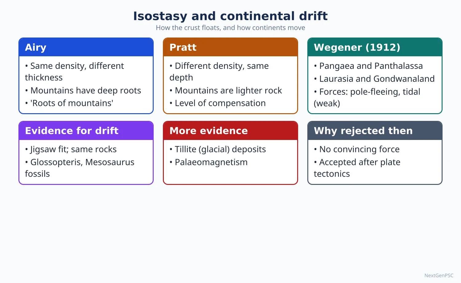
Pangaea and Panthalassa: about 300 million years ago (Carboniferous), all continents formed one supercontinent, Pangaea, surrounded by one ocean, Panthalassa.
Break-up: Pangaea split into Laurasia in the north and Gondwanaland in the south, separated by the Tethys Sea; these then broke into the present continents.
Forces Wegener proposed: the pole-fleeing force (polflucht), from the earth's rotation and flattening, moved continents towards the equator; tidal forces of the sun and moon moved them westward.
Purpose: Wegener, a climatologist, wanted to explain past climates, such as glaciation in present tropical lands and coal in polar lands.
4. Evidence for drift
Jigsaw fit: the coasts of South America and Africa match; Bullard and colleagues (1965) showed by computer that the fit is even better along the continental slope.
Geological match: similar rock belts and mountain trends continue across the Atlantic, for example the Caledonian belt of Scotland and Scandinavia with the Appalachians.
Fossils: the fern Glossopteris occurs in India, Africa, South America, Australia and Antarctica; the reptile Mesosaurus only in Brazil and South Africa; Lystrosaurus in India, Africa and Antarctica.
Tillite and glaciation: Permo-Carboniferous glacial deposits occur across the southern continents and India; in India they are the Talchir tillites at the base of the Gondwana sequence.
Placer deposits and coal: gold placers of Ghana appear to come from source rocks now in Brazil; coal seams in Antarctica show a warmer past position.
Indian example: the Gondwana coal basins of the Damodar, Mahanadi and Godavari valleys preserve the Glossopteris flora shared with other southern continents.
5. Criticism and later support
Weak forces: physicists such as Harold Jeffreys argued that pole-fleeing and tidal forces are far too weak to move continents.
Mechanism: continents could not plough through the strong ocean floor as Wegener suggested; he also gave no reason why Pangaea broke up only in the Mesozoic.
Support: Alexander du Toit, Our Wandering Continents (1937), added southern evidence; Arthur Holmes (1928–29) proposed mantle convection currents as a driving force.
Revival: palaeomagnetism and sea-floor spreading (Harry Hess, 1962) in the 1950s–60s revived drift, leading to plate tectonics; Wegener was right about drift, wrong about the forces.
6. Isostasy: concept
Definition: isostasy is the condition of gravitational equilibrium in which the lighter crust floats on the denser mantle so that equal masses lie above a certain depth everywhere; the term was coined by Clarence Dutton in 1889.
Origin of the idea: during the Great Trigonometrical Survey of India under George Everest, the plumb line near the Himalaya was deflected less than the mass of the mountains should cause; this showed that the Himalaya has a mass deficit beneath it.
Pratt's view (1855): J.H. Pratt held that the crust has a uniform depth of compensation, and higher areas are made of lighter rock while lower areas are of denser rock (mountains are high because they are light).
Airy's view (1855): G.B. Airy held that the crust has a uniform density but varying thickness, so mountains have deep roots in the denser layer, like icebergs in water (mountains are high because they are thick).
Hayford and Bowie: used the Pratt model in US geodetic work and estimated a depth of compensation of roughly 100 km.
Heiskanen (1920s–30s): combined both views: density and thickness both vary.
Vening Meinesz (1931): regional or flexural isostasy, in which the elastic lithosphere bends over a wide area under a load instead of each column adjusting locally; supported by gravity surveys over oceanic trenches.
7. Isostatic adjustment in nature
Glacial rebound: after the ice sheets melted, Fennoscandia (around the Gulf of Bothnia) and Hudson Bay in Canada have been rising, by up to about 1 cm a year in places.
Erosion and deposition: as mountains erode, they rise isostatically; as deltas load the crust, it sinks, as in the Ganga-Brahmaputra delta.
Indian examples: the Himalaya with its deep crustal root (about 70 km crust) and the subsiding foreland basin of the Indo-Gangetic plain under sediment load.
Gravity anomalies: where compensation is incomplete, gravity anomalies show it, such as negative anomalies over ocean trenches and young mountains still rising.
8. Diagrams to draw
Kober's model: draw two rigid foreland blocks with a sediment-filled trough between them; in a second sketch show arrows pushing the forelands together, two folded marginal ranges and an unfolded median mass in the middle; label Angaraland, Gondwanaland, Tethys, Kunlun, Himalaya, Tibet.
Airy model: draw blocks of the same shading (same density) at different heights with roots of matching depth hanging into the mantle.
Pratt model: draw blocks with a flat common base (level of compensation) but different heights and different shading for different densities.
Pangaea map: draw Laurasia in the north and Gondwanaland in the south separated by Tethys; place India between Africa, Antarctica and Australia and mark Glossopteris and tillite symbols across the southern continents.
9. Using it in the exam
10-mark answer: define isostasy and compare Airy and Pratt in a table with one diagram each.
15-mark answer: Wegener's theory, three to four evidences with Indian examples, two criticisms.
20-mark answer: geosynclinal origin of the Himalaya (Kober) versus the plate tectonic view, with diagrams.
Keywords: Pangaea, Tethys, Gondwanaland, polflucht, Glossopteris, orogen, kratogen, median mass, level of compensation, glacial rebound.
One-line definition: isostasy, in Dutton's sense, is the state of balance in which the earth's crust floats on the denser material beneath it.
| Basis | Airy | Pratt |
|---|---|---|
| Density of crustal columns | Uniform | Varies: higher areas lighter |
| Thickness of columns | Varies: mountains have deep roots | Uniform base at the level of compensation |
| Why mountains stand high | Because they are thick (root) | Because they are light |
| Analogy | Icebergs or wooden blocks of one kind floating in water | Blocks of different metals floating in mercury with a level base |
| Modern support | Seismic evidence of crustal roots under the Himalaya and Tibet | Density differences between oceanic and continental crust |
| Type | Example | Indian link |
|---|---|---|
| Fit of coastlines | South America and Africa | India fits against Madagascar, Antarctica and Australia in Gondwana reconstructions |
| Fossils | Glossopteris, Mesosaurus, Lystrosaurus | Glossopteris in Gondwana coal beds; Lystrosaurus in the Panchet beds of the Damodar valley |
| Palaeoclimate | Permo-Carboniferous glaciation of southern continents | Talchir tillites (Odisha and elsewhere) |
| Rock belts | Caledonian belt and the Appalachians | Ancient Peninsular cratons matched with Madagascar and East Antarctica |
| Palaeomagnetism (later) | Apparent polar wander paths | Deccan basalts record India's northward drift |
Mains points
- For Wegener, give the theory, four or five evidences, the forces he proposed and why they failed; end with how plate tectonics vindicated drift.
- For isostasy, define it with Dutton, explain its Himalayan origin in the Survey of India, and compare Airy and Pratt with diagrams; add Heiskanen and Vening Meinesz for higher marks.
- For geosynclines, Kober's model with a labelled diagram and the Himalaya-Tibet-Kunlun example is expected, followed by criticism and the plate tectonic reinterpretation.
- Use Indian evidence: Glossopteris and Talchir tillites in Gondwana basins, the Himalayan crustal root, subsidence of the Ganga plain.
- A common mistake is confusing Airy (roots, uniform density) with Pratt (uniform depth, varying density).
- Another mistake is calling Wegener's theory wrong; the drift was right, the mechanism was wrong.
- Glacial rebound in Fennoscandia and Hudson Bay is the best world example of isostatic adjustment.
Did you know?
- Isostasy was born in India: the puzzle of the Himalayan plumb-line deflection during the Great Trigonometrical Survey led Pratt and Airy to their 1855 models.
- Memory trick: 'Airy has Roots, Pratt has Plates of different weight' (Airy = thickness, Pratt = density).
Plate Tectonics and Mountain Building
Plate tectonics holds that the rigid lithosphere is broken into plates that move over the asthenosphere, meeting at divergent, convergent and transform boundaries. It grew from sea-floor spreading (Hess, 1962) and palaeomagnetism in the 1960s. Fold mountains such as the Himalaya are now explained by plate convergence and collision, replacing the older geosyncline and contraction theories.
In simple words
The earth's outer shell is cracked into giant pieces called plates that move a few centimetres a year, about as fast as fingernails grow.
Where plates pull apart, new ocean floor forms; where they push together, one dives under or both crumple into mountains.
This one idea explains earthquakes, volcanoes, ocean trenches and the Himalaya.
UPSC asks about plate boundaries with diagrams, how plate tectonics explains mountain building, and the evolution of the Himalaya.
1. From drift to plate tectonics
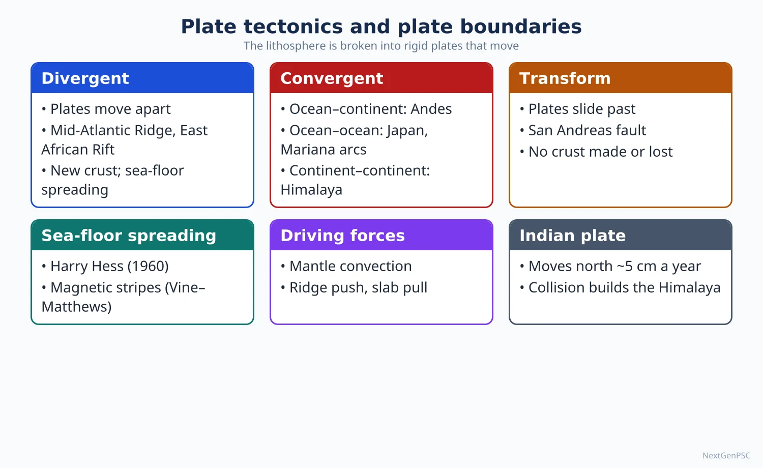
Sea-floor spreading: Harry Hess (History of Ocean Basins, 1962) proposed that hot mantle rises at mid-ocean ridges, creates new crust that moves sideways, and sinks back at trenches; Robert Dietz (1961) gave the name sea-floor spreading.
Evidence: symmetrical magnetic stripes (Vine and Matthews, 1963); ocean-floor rocks get older away from ridges; thin sediment near ridges; high heat flow at ridges; no ocean floor older than about 200 million years.
Synthesis: J. Tuzo Wilson described transform faults (1965); Dan McKenzie and Robert Parker (1967), W. Jason Morgan (1968) and Xavier Le Pichon (1968) gave the rigid-plate theory its geometric form.
Lithosphere and asthenosphere: plates are slabs of lithosphere about 100 km thick (thinner under oceans, thicker under old continents) that glide over the weak asthenosphere.
2. The plates
Major plates: Pacific, North American, South American, Eurasian, African, Antarctic and Indo-Australian (often split today into Indian and Australian plates).
Minor plates: Nazca, Cocos, Caribbean, Philippine Sea, Arabian, Juan de Fuca and Scotia, among others.
Rates: plates move about 2–10 cm a year; the Indian plate moves north-north-east at roughly 4–5 cm a year today, after moving much faster, perhaps around 15 cm a year, before collision (estimates vary).
3. Plate boundaries
Divergent (constructive): plates move apart and magma forms new crust; examples are the Mid-Atlantic Ridge, Iceland, and the East African Rift as a continental rift; India's example is the Carlsberg Ridge in the Arabian Sea.
Convergent (destructive), ocean-ocean: one oceanic plate subducts under another, forming a deep trench and a volcanic island arc, as in the Mariana Trench and the Japanese and Philippine arcs; the Andaman-Nicobar arc and Sunda trench are India's example.
Convergent, ocean-continent: the denser oceanic plate subducts under the continent, forming a trench and a volcanic fold mountain range, such as the Nazca plate under South America creating the Andes.
Convergent, continent-continent: both plates are too light to subduct deeply, so they crumple and thicken into high fold mountains with no active volcanoes, as in the Himalaya and the Alps.
Transform (conservative): plates slide past each other with no creation or destruction of crust, causing shallow earthquakes, as on the San Andreas fault in California and the Chaman fault on the western edge of the Indian plate.
Benioff zone: the inclined zone of earthquakes along a subducting slab, reaching about 700 km depth, named after Hugo Benioff (Wadati-Benioff zone).
4. Driving forces
Mantle convection: Arthur Holmes (1928–29) suggested heat-driven convection currents carry plates; today convection is seen as the overall engine.
Slab pull: the cold, dense sinking slab drags the rest of the plate; many studies, such as Forsyth and Uyeda (1975), found it the strongest force, since plates with long subducting edges move fastest.
Ridge push: the elevated ridge pushes the plate away by gravity.
Debate: the relative importance of convection, slab pull and ridge push is still debated.
Hotspots and mantle plumes: J. Tuzo Wilson (1963) explained the Hawaiian chain as a plate moving over a fixed hotspot; W.J. Morgan (1971) linked hotspots to deep mantle plumes; the Réunion hotspot is linked to the Deccan Traps, and the Ninety East Ridge is widely seen as the Kerguelen hotspot track.
5. Older views on mountain building
Contraction theory: Harold Jeffreys and others held that a cooling earth shrinks and wrinkles like a drying apple; rejected because radioactive heating means the earth is not simply cooling.
Kober's geosynclinal theory (1921): forelands squeeze a geosyncline (see the previous topic).
Daly's sliding theory (1926): R.A. Daly suggested that domed crust slid under gravity towards a geosyncline.
Joly's thermal cycle theory (1925): John Joly linked periodic melting of the sub-crust by radioactive heat to cycles of mountain building.
Holmes' convection current theory: converging currents drag crust down into a geosyncline and compress it; the closest forerunner of plate tectonics.
6. Recent views on mountain building
Orogeny by plate convergence: mountains form at convergent boundaries through subduction (Andean type), arc collision, or continental collision (Himalayan type).
Terrane accretion: small blocks such as island arcs and microcontinents are added to a continent's edge, building ranges such as the North American Cordillera.
Wilson cycle: oceans open by rifting and spreading and close by subduction and collision, so mountain belts mark old closed oceans (the Himalaya marks the closed Tethys).
Crustal thickening and isostasy: collision doubles crustal thickness to about 70 km under Tibet, and isostasy keeps the region high.
Erosion-tectonics link (debated): some researchers argue that heavy monsoon erosion on the Himalayan front helps uplift through isostatic rebound and channel flow of hot mid-crust; the strength of this link is debated.
7. Evolution of the Himalaya
Northward journey: after Gondwana broke up, India separated from Madagascar in the Late Cretaceous and moved north, passing over the Réunion hotspot when the Deccan Traps erupted about 66 million years ago.
Collision: India collided with Asia around 50 million years ago (estimates range from about 60 to about 40 million years and are debated), closing the Tethys along the Indus-Tsangpo Suture Zone.
Thrust sheets: continued convergence stacked the Indian crust into southward-younging thrusts: the Main Central Thrust (Greater Himalaya over Lesser Himalaya), the Main Boundary Thrust (Lesser Himalaya over Shiwaliks) and the Main Frontal Thrust (Shiwaliks over the Gangetic plain).
Ranges by age: the Trans-Himalaya and Greater Himalaya rose first; the Lesser Himalaya next; the Shiwaliks, made of debris eroded from the higher ranges, are the youngest.
Still rising: ongoing convergence causes great earthquakes along the Himalayan front (Assam 1950, Nepal 2015) and builds the foreland basin of the Ganga plain.
Other Indian examples: the Andaman-Nicobar arc (subduction), and the Aravalli (a very old, eroded fold belt of Proterozoic age).
8. Diagrams to draw
World plate map: draw the world outline, mark plate boundaries with symbols (double lines for ridges, saw-teeth for trenches, single lines for transforms) and arrows of movement; highlight the Indian plate.
Three convergent cross-sections: ocean-ocean (trench and island arc), ocean-continent (trench and Andes-type volcanic range), continent-continent (thickened crust, no trench).
Himalayan cross-section, south to north: Gangetic plain → MFT → Shiwaliks → MBT → Lesser Himalaya → MCT → Greater Himalaya → Tethys Himalaya → Indus-Tsangpo Suture → Tibet; show the Indian plate dipping under Asia.
India's drift map: show India's positions at about 70, 50 and 10 million years ago moving north from the Southern Hemisphere, with the Réunion hotspot marked.
9. Using it in the exam
10-mark answer: define one boundary type, give an example, draw the cross-section.
15-mark answer: plate tectonics as an explanation of earthquakes and volcanoes, with a world map.
20-mark answer: recent views on mountain building with the Himalaya as a case study, with cross-section and a comparison with older theories.
Keywords: lithosphere, asthenosphere, subduction, Benioff zone, slab pull, Wilson cycle, suture zone, MCT, MBT, MFT.
One-line definition: plate tectonics is the theory that the lithosphere consists of rigid plates whose relative motion creates, destroys or shears crust at their margins.
| Boundary | Motion | Landforms | Examples (India first) |
|---|---|---|---|
| Divergent | Apart | Mid-ocean ridge, rift valley | Carlsberg Ridge; Mid-Atlantic Ridge, East African Rift |
| Convergent: ocean-ocean | Together, subduction | Trench, island arc | Andaman-Nicobar arc and Sunda trench; Mariana, Japan |
| Convergent: ocean-continent | Together, subduction | Trench, volcanic fold mountains | Andes, Cascades |
| Convergent: continent-continent | Together, collision | High fold mountains, thick crust | Himalaya; Alps |
| Transform | Past each other | Fault zones, offset ridges | Chaman fault (Pakistan-Afghanistan); San Andreas |
Mains points
- Explain how plate tectonics grew from drift, palaeomagnetism and sea-floor spreading; name Hess, Vine-Matthews, Wilson, McKenzie and Morgan correctly.
- Every boundary answer needs a cross-section; the three convergent types are the most asked.
- For 'recent views on mountain building', contrast older theories (contraction, Kober, Joly, Daly, Holmes) with plate convergence, terrane accretion and the Wilson cycle.
- Use the Himalaya as the Indian case study: suture zone, MCT, MBT, MFT, age sequence of ranges, ongoing seismicity.
- Mention that the date of the India-Asia collision and the relative strength of driving forces are debated.
- A common mistake is placing volcanoes in the Himalaya; continent-continent collision produces no active volcanic arc.
- Link plate tectonics to Indian hazards: Himalayan earthquakes, the 2004 Sumatra-Andaman earthquake and tsunami.
Did you know?
- Marine limestone with fossils from the old Tethys Sea lies near the summit of Mount Everest, showing that ocean floor was lifted almost 9 km by the collision.
Volcanicity, Earthquakes and Tsunamis
Volcanicity covers all processes by which magma rises into or onto the crust, forming extrusive forms (shield, composite, caldera, flood basalt) and intrusive forms (batholith, sill, dyke). Earthquakes are sudden releases of strain along faults, explained by Reid's elastic rebound theory; most occur along plate boundaries such as the Pacific Ring of Fire and the Alpine-Himalayan belt. A tsunami is a series of long ocean waves generated mainly by undersea earthquakes that lift or drop the sea floor, as in the 2004 Indian Ocean tsunami.
In simple words
Volcanoes, earthquakes and tsunamis are the earth's sudden ways of releasing energy built up by moving plates and inner heat.
An earthquake is like bending a stick until it snaps: strain builds slowly along a fault, then releases in seconds.
These hazards kill thousands and shape landforms, so mapping where they occur guides building codes and warning systems.
UPSC asks about their world distribution, landforms, India's seismic zones and tsunami preparedness.
1. Volcanicity: concepts
Magma and lava: molten rock below the surface is magma; once erupted it is lava; basaltic lava is low in silica, hot and runny, while andesitic and rhyolitic lavas are silica-rich, viscous and explosive.
Causes: decompression melting at ridges and hotspots, melting from water released by subducting slabs, and heat from mantle plumes.
Products: lava flows, pyroclastic material (ash, lapilli, bombs), gases (water vapour, carbon dioxide, sulphur dioxide), pyroclastic flows and lahars (volcanic mudflows).
Activity: active, dormant and extinct volcanoes; the Volcanic Explosivity Index (Newhall and Self, 1982) rates eruptions from 0 to 8.
2. Types of eruption and extrusive landforms
Eruption styles, from mild to violent: Hawaiian (fluid lava fountains), Strombolian (regular small bursts, Stromboli in Italy), Vulcanian (short explosive blasts), Pelean (glowing avalanches, Mont Pelée 1902), Plinian (tall eruption columns, Vesuvius AD 79 described by Pliny the Younger).
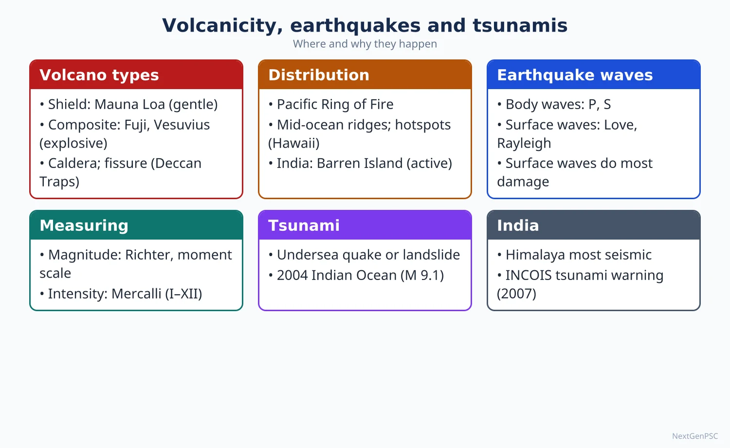
Shield volcano: broad, gentle slopes built by fluid basalt, such as Mauna Loa in Hawaii.
Composite or strato-volcano: steep cone of alternate lava and ash layers, explosive, such as Fuji, Mount St Helens and Vesuvius.
Cinder cone: small steep cone of loose fragments, such as Parícutin in Mexico, which grew from a cornfield in 1943.
Caldera: a large depression formed when a volcano collapses after emptying its magma chamber, such as Krakatoa (1883) and Lake Toba in Sumatra.
Fissure eruptions and flood basalts: lava pours from long cracks and spreads in sheets, building plateaus such as the Deccan Traps and the Columbia Plateau.
3. Intrusive forms
Batholith: a huge dome of granite cooled deep in the crust, exposed after erosion; much of the granite of the Peninsula and the Himalayan core is batholithic.
Laccolith: a mushroom-shaped intrusion that arches the overlying beds; lopolith is saucer-shaped; phacolith is lens-shaped along the crest or trough of folds.
Sill: a horizontal sheet intruded along bedding planes; dyke: a vertical wall-like sheet cutting across beds, common in the Deccan region and the Singhbhum area.
4. Distribution of volcanoes
Pacific Ring of Fire: a belt of subduction zones around the Pacific holding most of the world's active volcanoes, from the Andes through Alaska and Japan to Indonesia and New Zealand.
Mid-ocean ridges: mostly submarine; Iceland on the Mid-Atlantic Ridge is the exposed example.
Rift valleys: East African Rift (Kilimanjaro, Nyiragongo).
Mediterranean-Asian belt: Vesuvius, Etna, Stromboli and volcanoes of Turkey and Iran.
Hotspots: Hawaii, Yellowstone, Réunion.
India: Barren Island in the Andaman Sea is India's only active volcano, with eruptions recorded since 1991; Narcondam island is generally considered dormant; the Deccan Traps (about 66 million years) and the older Rajmahal Traps are ancient flood basalts.
Caution: Lonar lake in Maharashtra is a meteorite impact crater in basalt, not a volcanic crater.
Effects: fertile soils (the black soils of the Deccan, Java), geothermal energy (Iceland), minerals and tourism; hazards include ash, lahars (Armero, Colombia, 1985) and global cooling after large eruptions such as Tambora (1815, followed by the 'year without a summer' in 1816) and Pinatubo (1991).
5. Earthquakes: mechanism and measurement
Elastic rebound theory: H.F. Reid (1910), after the 1906 San Francisco earthquake, explained that rocks on both sides of a fault bend under stress until friction is overcome, then slip and snap back, releasing energy as seismic waves.
Focus and epicentre: the focus (hypocentre) is the point of rupture underground; the epicentre is the point on the surface directly above it, where shaking is usually strongest.
Depth classes: shallow (0–70 km, most damaging), intermediate (70–300 km) and deep (300–700 km, only in subduction zones).
Waves: body waves (P and S) and surface waves (Love waves with sideways motion and Rayleigh waves with rolling motion); surface waves cause most damage.
Magnitude: energy released; Charles Richter's local magnitude scale (1935) is logarithmic; the moment magnitude scale (Hanks and Kanamori, 1979) is now standard for large quakes; each whole number is about 32 times more energy.
Intensity: observed effects at a place, measured on the Modified Mercalli scale (I to XII) or the MSK-64 scale used in India.
Causes: tectonic (most), volcanic, collapse, and human-induced, such as reservoir-induced seismicity; the 1967 Koyna earthquake in Maharashtra (about magnitude 6.3) is the classic Indian case.
6. Distribution of earthquakes
Circum-Pacific belt: the largest share of earthquakes, including the largest recorded, Chile 1960 (magnitude 9.5), and Tohoku, Japan, 2011 (about 9.0–9.1).
Alpine-Himalayan belt: from the Mediterranean through Turkey, Iran and the Himalaya to Myanmar, such as Turkey-Syria (February 2023, magnitude 7.8) and Myanmar (March 2025, magnitude 7.7 on the Sagaing fault).
Mid-ocean ridges and rifts: frequent but mostly small, shallow quakes.
Intraplate earthquakes: away from boundaries, on old faults, such as Latur (Killari) 1993 and Bhuj 2001 in India.
7. Earthquakes in India
Major events: Assam 1897, Kangra 1905, Bihar-Nepal 1934, Assam-Tibet 1950 (about 8.6, India's largest recorded), Koyna 1967, Uttarkashi 1991, Latur 1993, Jabalpur 1997, Bhuj 2001 (about 7.7), Kashmir 2005, Sikkim 2011, Nepal 2015 (7.8, felt widely in north India).
Seismic zoning: the Bureau of Indian Standards code IS 1893 (Part 1) divides India into zones II to V (V most severe: the North-East, Jammu and Kashmir, Himachal Pradesh, Uttarakhand, Kachchh, north Bihar and the Andaman and Nicobar Islands); NDMA estimates about 59% of India's land is prone to moderate to severe earthquakes; BIS revises the map periodically, so quote the edition you use.
Central seismic gap (debated): some seismologists argue that the stretch of the Himalaya between the 1905 Kangra and 1934 Bihar-Nepal ruptures has stored strain for a future great earthquake; its timing cannot be predicted.
Mitigation: earthquake-resistant building codes, retrofitting, NDMA guidelines, microzonation of cities such as Delhi, and public drills.
8. Tsunamis
Meaning: a Japanese word meaning 'harbour wave'; a series of very long waves caused by sudden displacement of a large volume of sea water.
Causes: mainly megathrust earthquakes at subduction zones that lift or drop the sea floor; also submarine landslides, volcanic eruptions (Krakatoa 1883, Hunga Tonga 2022) and rarely meteorite impacts.
Behaviour: in deep ocean the waves travel at about 700–800 km/h with wavelengths of hundreds of kilometres but heights below a metre; near the coast they slow, shorten and rise sharply (shoaling); the sea often draws back first.
2004 Indian Ocean tsunami: on 26 December 2004 a magnitude 9.1 earthquake off Sumatra ruptured northward along the Andaman-Nicobar arc; about 230,000 people died in over a dozen countries; in India Tamil Nadu (especially Nagapattinam) and the Andaman and Nicobar Islands were worst hit.
Warning in India: the Indian Tsunami Early Warning Centre at INCOIS, Hyderabad, operational since 2007, uses seismographs, bottom pressure recorders and tide gauges; it serves as a regional provider for the Indian Ocean.
Threat sources for India: the Andaman-Sumatra subduction zone in the east and the Makran subduction zone off Pakistan and Iran in the west (the 1945 Makran tsunami reached the Gujarat and Mumbai coasts).
Mitigation: warning and evacuation drills, coastal regulation zones, shelterbelts and mangroves (studies after 2004 around Pichavaram suggested mangroves reduced damage, though the extent is debated), and community programmes such as UNESCO's Tsunami Ready recognition given to two Odisha villages in 2020.
9. Diagrams to draw
Volcano cross-section: magma chamber, main vent, side vent, crater, alternate lava and ash layers in a composite cone; beside it a broad shield and a collapsed caldera.
Intrusive forms: one block diagram showing a batholith at depth with a laccolith, sill and dyke branching upward.
Focus and epicentre: fault plane, focus below, epicentre above, circles of decreasing intensity (isoseismal lines).
World map: shade the Ring of Fire, Alpine-Himalayan belt and mid-ocean ridges; mark Barren Island, Bhuj, Latur, Koyna and the 2004 epicentre.
Tsunami stages: sea-floor uplift, long low wave in deep water, wave slowing and growing near the shore.
10. Using it in the exam
10-mark answer: define one landform or term (caldera, Benioff zone, elastic rebound) with a diagram and example.
15-mark answer: world distribution of earthquakes and volcanoes explained by plate tectonics, with a map.
20-mark answer: India's earthquake or tsunami vulnerability, seismic zones, case studies and preparedness.
Keywords: Ring of Fire, elastic rebound, focus, epicentre, moment magnitude, intensity, seismic gap, megathrust, INCOIS.
One-line definition: an earthquake is the shaking of the ground caused by the sudden release of energy stored in rocks, usually by slip along a fault.
| Landform | Lava or material | Shape | Example |
|---|---|---|---|
| Flood basalt plateau | Fluid basalt from fissures | Flat, step-like (trap) layers | Deccan Traps; Columbia Plateau |
| Shield volcano | Fluid basalt | Broad, gentle dome | Mauna Loa |
| Composite cone | Alternate lava and ash, viscous | Steep, symmetrical cone | Fuji, Vesuvius; Barren Island is a stratovolcano |
| Cinder cone | Loose pyroclasts | Small, steep cone | Parícutin |
| Caldera | Collapse after large eruption | Wide basin, often a lake | Toba, Krakatoa |
| Basis | Magnitude | Intensity |
|---|---|---|
| Measures | Energy released at the source | Effects and damage at a place |
| Scale | Richter (1935), moment magnitude (1979) | Modified Mercalli (I–XII), MSK-64 |
| Value per earthquake | One value | Varies from place to place |
| Basis of measurement | Seismograph records | Observation of effects |
Mains points
- Always explain distribution through plate tectonics and show it on a world map; this is the most common angle.
- Distinguish magnitude from intensity, and focus from epicentre; examiners notice loose use of these terms.
- Give Indian case studies: Barren Island, Deccan Traps, Koyna (reservoir-induced), Latur and Bhuj (intraplate), Himalayan great earthquakes, the 2004 tsunami.
- For tsunami questions, cover generation, behaviour near the coast, the 2004 event and India's warning system at INCOIS.
- Add management: seismic zoning, building codes, microzonation, early warning, mangroves and community preparedness.
- A common mistake is calling Lonar a volcanic crater; it is an impact crater.
- Mark predictions about the central seismic gap as debated; earthquakes cannot be forecast by date.
Did you know?
- In the deep ocean a tsunami may pass under a ship almost unnoticed, yet travel as fast as a jet plane.
- Memory trick for eruption styles from gentle to violent: 'Happy Students Visit Pune Picnics' = Hawaiian, Strombolian, Vulcanian, Pelean, Plinian.
UPSC Previous Year Questions: The Earth's Interior and Tectonics
From 2014 to 2026 UPSC asked 13 question parts worth 215 marks from this chapter, all in Paper I. Plate tectonics and mountain building dominate (8 parts, 135 marks), followed by geosynclines and drift (2 parts, 40 marks) and volcanoes and earthquakes (3 parts, 40 marks). Every question below has a model answer written to the UPSC word limit.
In simple words
Read the question and the approach line, then write your own answer in the time limit: about 7 minutes for 10 marks, 10 for 15 marks and 12 for 20 marks.
Compare your answer with the model: check the definition and the geographer, the processes, the named examples and the diagram.
Note what you missed and revise that topic in the notes before trying the next question.
1. Geosynclines, Continental Drift and Isostasy
Example 1 (UPSC 2020, 20 marks): Write an essay on the evolution of continents and oceans using various theories and models.
Paper and question: Paper I, Q2(a)
Approach: An essay tracing ideas on how continents and ocean basins took their present form, from early fixist and contraction views to drift, sea-floor spreading and plate tectonics; end with the Wilson cycle and a diagram of the theories in sequence.
The distribution of continents (about 29% of the earth's surface) and oceans (about 71%) is the earth's first-order relief. Explanations have moved from a fixist view, in which both are permanent, to a mobilist view, in which both are born, move and are destroyed.
Early fixist ideas included Lowthian Green's tetrahedral hypothesis (1875), in which a shrinking earth takes a tetrahedral shape with oceans on the faces and continents at the corners, and Jeffreys' contraction theory. They explained the antipodal position of land and water but not the matching shapes of opposite coasts.
Alfred Wegener's continental drift (1912, book 1915) proposed a single landmass, Pangaea, which broke up from the Mesozoic. His evidence was the fit of South America and Africa, Glossopteris and Mesosaurus fossils across Gondwana, and Permo-Carboniferous glacial deposits in India, Africa and Australia. His driving forces were too weak, so the theory was rejected.
Arthur Holmes (1928–29) supplied a mechanism, mantle convection currents. Harry Hess (1962) proposed sea-floor spreading: new crust forms at mid-ocean ridges and sinks at trenches, confirmed by magnetic striping (Vine and Matthews, 1963).
The synthesis came as plate tectonics (1965–68): rigid lithospheric plates move over the asthenosphere. Oceans open at divergent margins (Red Sea, East African Rift) and close at convergent margins, as the Tethys closed to form the Himalaya.
Diagram: A time-line strip showing Pangaea (about 250 million years ago), the Laurasia–Gondwana split and present continents, with arrows for ridge, trench and Wilson cycle stages.
J. Tuzo Wilson's cycle links these ideas: rifting, opening, subduction, closing and collision repeat, as earlier supercontinents such as Rodinia show. Continents are old (up to about 4 billion years) while ocean floors are young (under about 200 million years), a contrast only the mobilist view explains.
Example 2 (UPSC 2018, 20 marks): Evaluate how far Kober's geosynclinal theory explains the mountain building process.
Paper and question: Paper I, Q2(a)
Approach: Evaluate Kober's theory: state its basis (contraction, forelands, orogen), the stages and the structures it predicts with examples, then weigh what it explains against its shortcomings, ending with the plate-tectonic view; draw the forelands–geosyncline diagram.
The Austrian geologist Leopold Kober put forward his geosynclinal theory in Der Bau der Erde (1921) to explain fold mountains. It rests on contraction of the earth through cooling, which generates horizontal compression.
Kober saw rigid masses, the forelands or kratogen, separated by long mobile troughs, the geosynclines or orogen. Mountain building has three stages: lithogenesis, when rivers fill the subsiding geosyncline with sediment; orogenesis, when the forelands move towards each other and squeeze the sediments into folds; and gliptogenesis, when denudation lowers the ranges.
If both forelands move, two marginal ranges (Randketten) form with an unfolded median mass (Zwischengebirge) between them, such as the Tibetan plateau between the Kunlun and the Himalaya and the Hungarian basin between the Carpathians and the Dinaric Alps.
Diagram: Cross-section showing two forelands with inward arrows, a sediment-filled geosyncline, and after compression two marginal ranges with a median mass between them.
Strengths: it explains why fold mountains are long, narrow and built of thick marine sediments (Tethyan fossils high in the Himalaya), why they border stable blocks, and why intermontane plateaus occur. It gave a clear sequence of sedimentation, folding and erosion.
Weaknesses: cooling contraction cannot supply enough shortening, and radioactive heat shows the earth is not simply cooling. It cannot explain how rigid forelands move, the great nappes of the Alps, or the one-sided folding of the Himalaya where only the Indian block moved north. It ignores the distribution of earthquakes and volcanoes and volcanic arcs that lack a geosyncline.
Thus Kober describes the stages of mountain building well but explains its cause poorly. Plate tectonics keeps the idea of sediments compressed between rigid blocks but replaces contraction with plate convergence: the Tethys sediments were folded into the Himalaya by India–Eurasia collision, not by a shrinking earth.
2. Plate Tectonics and Mountain Building
Example 3 (UPSC 2025, 10 marks): What geological and tectonic processes lead to the formation of nappes in orogenic belts?
Paper and question: Paper I, Q1(c)
Approach: Define nappes, then explain the tectonic setting (collision and crustal shortening) and the processes (recumbent folding, thrusting on weak layers, fluid pressure, gravity sliding, erosion into klippen and windows), with Alpine and Himalayan examples and a sketch.
A nappe is a large sheet of rock carried several to tens of kilometres over younger rocks along a low-angle thrust or by extreme recumbent folding. The term was first used in the Alps.
Setting: nappes form in continent–continent collision belts where horizontal compression shortens the crust by hundreds of kilometres, as in the Alps (Africa–Europe) and the Himalaya (India–Eurasia).
Processes: (i) folds tighten into recumbent folds whose stretched lower limb is cut by a thrust, so the upper limb travels forward as a fold nappe; (ii) slabs slide along a décollement, a weak layer of shale, salt or gypsum; (iii) high fluid pressure reduces friction and permits long transport; (iv) uplift creates slopes down which sheets glide under gravity; (v) erosion later isolates outliers (klippen) and cuts windows exposing the rocks beneath.
Diagram: Section showing a recumbent fold passing into a thrust, a transported nappe, a klippe and a tectonic window.
Examples are the Helvetic and Penninic nappes of the Swiss Alps, the Krol and Almora nappes of the Lesser Himalaya and the Caledonian nappes of Scandinavia. Nappes are thus the signature of extreme crustal shortening during orogeny.
Example 4 (UPSC 2025, 15 marks): "The Himalaya is still rising." Expand this statement and describe the processes involved in it with suitable sketches and examples.
Paper and question: Paper I, Q3(c)
Approach: Expand the statement with evidence that the Himalaya is still rising, then describe the processes (continued India–Eurasia convergence, thrusting on the frontal faults, isostatic rebound due to erosion) with a sketch and examples, and conclude on hazards.
The Himalaya, the youngest major fold mountain system, formed by the collision of the Indian and Eurasian plates that began about 50 million years ago (the date is debated). The collision continues, so the range is still being shortened and uplifted.
Evidence: GPS shows India still moving north-north-east at about 4–5 cm a year, of which roughly 2 cm a year is absorbed across the Himalaya. Raised river terraces, folded Siwalik gravels, fresh fault scarps, great earthquakes (Assam 1950, Gorkha 2015) and still-deepening gorges of the Indus, Sutlej and Arun record active deformation.
Process 1, plate convergence: India underthrusts Tibet along the Main Himalayan Thrust, and strain is released on thrusts splaying from it, the Main Central Thrust, Main Boundary Thrust and, at the front, the Main Frontal Thrust, which folds and lifts the Siwaliks.
Process 2, southward migration: thrusting has stepped from the Greater to the Lesser Himalaya and then the Siwaliks, so the front advances over the Indo-Gangetic foreland basin.
Process 3, isostatic rebound: rapid glacial and river erosion removes mass and the thickened crust floats upward, lifting peaks even as valleys deepen.
Diagram: North–south section from the Ganga plain to Tibet showing the under-thrusting Indian plate, the MFT, MBT and MCT splaying from the Main Himalayan Thrust, and arrows for uplift and erosion.
The rise is partly offset by erosion and by collapse along north–south rifts in southern Tibet. Continued uplift makes the Himalaya a zone of high earthquake and landslide hazard, which must guide building codes and hydropower planning.
Example 5 (UPSC 2024, 20 marks): Examine the recent views on mountain building process and divide the world mountains on the basis of their genesis.
Paper and question: Paper I, Q2(a)
Approach: First examine how views on mountain building have changed (from geosyncline and contraction to plate tectonics, terrane accretion, orogenic wedges and erosion–tectonics coupling), then classify world mountains by genesis with examples; add a diagram of plate settings.
Mountain building or orogeny was once explained by the geosynclinal and contraction theories of Dana, Kober and Jeffreys. Since the 1960s plate tectonics has been the accepted framework, refined by newer research.
Recent views: (i) plate convergence builds mountains by ocean–continent subduction (Andes), ocean–ocean subduction forming island arcs (Japan, Aleutians) and continent–continent collision (Himalaya, Alps); (ii) terrane accretion adds microcontinents and arcs to continental edges, as in the North American Cordillera; (iii) the orogenic wedge model treats a range like soil before a bulldozer, growing until it reaches a critical taper; (iv) tectonics–climate coupling: heavy monsoon erosion on the Himalayan front speeds rock uplift, and Molnar and England (1990) argued that some apparent uplift is an isostatic response to erosion; (v) mantle plumes raise volcanic mountains inside plates; (vi) thickened ranges may spread under their own weight, as in Tibet.
Classification by genesis: (1) Fold mountains, formed by compression: young (Tertiary) ones such as the Himalaya, Alps, Rockies and Andes; old ones such as the Appalachians and Urals.
(2) Block mountains, formed by faulting: the Vosges and Black Forest beside the Rhine graben, the Sierra Nevada and the Satpura.
(3) Volcanic mountains: Fuji, Kilimanjaro and Mauna Loa. (4) Dome mountains, raised by intrusions or upwarping: the Black Hills and the laccolithic Henry Mountains of Utah. (5) Residual mountains, worn remnants of older uplands: the Aravallis and Eastern Ghats.
Diagram: Three small sections showing ocean–continent, ocean–ocean and continent–continent convergence with the resulting mountain types.
Recent views thus see mountain building as the joint work of plate motion, mantle processes, erosion and gravity, which explains the variety of world mountains.
Example 6 (UPSC 2023, 20 marks): "Evidences from palaeomagnetism and sea floor spreading have validated that continents and ocean basins have never been stationary." Elucidate with suitable diagrams.
Paper and question: Paper I, Q2(a)
Approach: Elucidate how palaeomagnetism (apparent polar wander, magnetic latitude) and sea-floor spreading (magnetic stripes, age and sediments of the ocean floor, heat flow, drilling) prove mobility of continents and oceans; include diagrams of polar wander paths and symmetric magnetic stripes.
Wegener's drift theory (1915) was rejected for lack of a mechanism and hard proof. From the 1950s, palaeomagnetism and sea-floor spreading gave quantitative evidence that continents and ocean basins move.
Palaeomagnetism: iron minerals in cooling lava lock in the direction of the earth's field, and the inclination gives the latitude of formation. Rocks of different ages in Europe point to different poles, tracing an apparent polar wander path. The paths of Europe and North America are similar but displaced and coincide only if the Atlantic is closed (Runcorn, 1956). As there was one pole, the continents must have moved.
India: palaeomagnetic data from the Deccan Traps (about 66 million years old) show they formed in the southern hemisphere, proving India's northward journey to Asia.
Sea-floor spreading: Harry Hess (1962) proposed that crust forms at mid-ocean ridges and sinks at trenches. Vine and Matthews (1963) found magnetic stripes of normal and reversed polarity lying symmetrically on both sides of ridges, a tape recording of field reversals.
Support: ocean-floor age increases away from ridges and nowhere exceeds about 180–200 million years, while continental rocks reach about 4 billion years; sediments thicken away from ridges; heat flow peaks at ridges; Deep Sea Drilling Project cores (Glomar Challenger, from 1968) confirmed the age pattern; and Wilson's transform faults (1965) and the Hawaiian–Emperor hotspot chain show the direction of plate motion.
Diagram: (a) Apparent polar wander paths of Europe and North America, separate and then merged after closing the Atlantic; (b) a mid-ocean ridge with symmetric black–white magnetic stripes and arrows of spreading.
This evidence validates the statement: ocean basins are continually created and destroyed, and continents ride on moving plates, turning drift into the accepted theory of plate tectonics.
Example 7 (UPSC 2022, 15 marks): With the help of suitable sketches describe the mountain genesis and mountain types. Give suitable examples from various mountain systems of the world.
Paper and question: Paper I, Q4(c)
Approach: Describe mountain genesis (geosynclinal and plate-tectonic views of orogeny, faulting, volcanism, denudation) and then the types of mountains with examples from world systems; support with labelled sketches of fold, block and volcanic mountains.
A mountain is a landform rising steeply well above its surroundings with a small summit area. Mountains arise from endogenetic forces, compression, tension and volcanism, and are later shaped by denudation.
Genesis: classical theories (Kober, Holmes) traced fold mountains to compression of geosynclinal sediments. Plate tectonics now explains most mountains at plate margins: subduction raises the Andes and island arcs such as Japan, and collision raised the Himalaya and Alps. Tension at divergent zones forms rift blocks (East African highlands), and hotspots build volcanoes inside plates (Hawaii).
Types: (1) Fold mountains: young Alpine–Himalayan and Circum-Pacific chains (Himalaya, Alps, Rockies, Andes) and old Caledonian and Hercynian chains (Appalachians, Urals, Aravallis).
(2) Block mountains: horsts between faults, such as the Vosges and Black Forest flanking the Rhine rift valley, the Sierra Nevada and the Satpura.
(3) Volcanic mountains: Kilimanjaro, Fuji, Cotopaxi and Mauna Loa. (4) Dome mountains: the Black Hills of South Dakota. (5) Residual mountains: remnants of denudation such as the Aravallis, Eastern Ghats and Scottish Highlands.
Diagram: Three labelled sketches: an anticline–syncline fold belt, a horst between two normal faults beside a graben, and a stratovolcano with crater and vent.
Most great systems combine origins: the Andes have both fold ranges and volcanoes, and old fold belts survive as residual hills, so genesis and age must be read together.
Example 8 (UPSC 2021, 20 marks): The concept of Plate tectonics has been derived from the isostasy and continental drift theory. Elaborate citing suitable examples.
Paper and question: Paper I, Q2(a)
Approach: Elaborate how isostasy (light crust floating on a yielding substratum) and continental drift (horizontal movement of continents) fed into sea-floor spreading and plate tectonics; cite examples for each link and close with what plate tectonics added; include a diagram.
Plate tectonics, formulated in 1965–68, holds that rigid lithospheric plates move over a weak asthenosphere. It did not arise suddenly; it combined two older ideas, isostasy, which explains vertical balance, and continental drift, which proposed horizontal movement.
Isostasy: Pratt and Airy (1855) explained the smaller-than-expected gravitational pull of the Himalaya. Airy proposed that mountains have deep roots of light crust floating in denser material, like icebergs; Pratt proposed differences in density. Both implied that the crust floats on a substratum that yields slowly. Post-glacial rebound of Fennoscandia and Hudson Bay, still rising after ice melted, proved the mantle flows over long periods.
Contribution: if the crust floats and the substratum can flow, continents can also move sideways. This weak layer is today's asthenosphere, over which plates glide, and isostatic adjustment explains why oceanic plates subside as they cool away from ridges.
Continental drift: Wegener (1915) used isostasy to argue that light sial floats on dense sima and can drift. His evidence, the fit of Atlantic coasts, Glossopteris flora across India, Africa, South America, Antarctica and Australia, Gondwana glacial deposits and matching mountain belts, established that continents were once joined.
Contribution: drift gave plate tectonics the idea of large horizontal movement and a supercontinent, Pangaea. Its weakness, the absence of a force, was overcome by Holmes' convection currents, Hess's sea-floor spreading (1962) and palaeomagnetic evidence.
Diagram: Flow chart: isostasy (floating crust, yielding mantle) and drift (moving continents) joined by convection and sea-floor spreading, leading to plate tectonics.
Plate tectonics went further: oceans as well as continents move, the lithosphere rather than the crust is the moving layer, and boundaries explain the belts of earthquakes, volcanoes and mountains such as the Himalaya. Thus it is the synthesis of isostasy and drift, enriched by ocean-floor evidence.
Example 9 (UPSC 2019, 15 marks): Compare and contrast different types of plate boundaries.
Paper and question: Paper I, Q2(b)
Approach: Compare and contrast divergent, convergent (three sub-types) and transform boundaries on motion, crust, landforms, earthquakes and volcanism with named examples, noting common features and differences; include a block diagram.
Plates interact along three kinds of boundaries, classed by relative motion. All are zones of concentrated earthquakes, but they differ in whether crust is created, destroyed or conserved.
Divergent (constructive): plates move apart and magma rises to form new crust. Ocean examples are the Mid-Atlantic Ridge and East Pacific Rise; on land, the East African Rift and Red Sea show early stages. Features: ridges, rift valleys, shallow earthquakes, basaltic fissure volcanism (Iceland).
Convergent (destructive): plates collide and crust is consumed. (a) Ocean–continent: the denser plate subducts, forming a trench and volcanic fold range (Peru–Chile Trench, Andes). (b) Ocean–ocean: an island arc forms (Mariana Trench, Japan). (c) Continent–continent: buoyant crust cannot subduct and is thickened (Himalaya). Earthquakes reach about 700 km deep along the inclined Benioff zone; volcanoes are explosive andesitic, except in collision zones.
Transform (conservative): plates slide past each other and crust is neither made nor destroyed, as on the San Andreas Fault and the Alpine Fault of New Zealand, and across ridge offsets. Earthquakes are shallow but can be strong; there is no volcanism.
Diagram: Block diagram showing a spreading ridge offset by transform faults, a subduction zone with trench and volcanic arc, and a collision zone with folded mountains.
Contrast in brief: divergent boundaries are tensional, convergent compressional and transform shearing; only convergent boundaries have deep earthquakes and great mountains. Many boundaries are mixed, as in the oblique Sumatra subduction zone, so real margins often combine types.
Example 10 (UPSC 2014, 20 marks): State the concept of plate tectonics. How does it help in explaining the formation of the Himalayas and Appalachian Mountains?
Paper and question: Paper I, Q2(a)
Approach: State the concept of plate tectonics briefly, then explain the Himalaya (Tethys closure, India–Eurasia collision, suture zone, thrust sequence) and the Appalachians (Palaeozoic closure of the Iapetus, three orogenies, later Atlantic opening) as two stages of the plate cycle; draw sections.
Plate tectonics (1965–68, building on Wegener, Holmes and Hess) holds that the lithosphere is divided into about seven major and many minor rigid plates that move over the asthenosphere, driven by mantle convection, ridge push and slab pull. Mountains rise mainly at convergent boundaries.
Himalaya: after Gondwana broke up, the Indian plate moved rapidly north, and the Tethys ocean floor ahead of it subducted beneath Asia. When the continents collided, about 50 million years ago (debated), the thick Tethyan sediments were scraped up, folded and thrust southwards. The Indus–Tsangpo Suture Zone, with ophiolites (slices of ocean floor), marks the join.
As India kept pushing, deformation stepped south along the Main Central, Main Boundary and Main Frontal Thrusts, forming the Greater Himalaya, Lesser Himalaya and Siwaliks in sequence. Marine fossils high on Everest's slopes, frequent earthquakes and continuing uplift support this.
Appalachians: these older mountains formed in the Palaeozoic as the Iapetus Ocean closed. Island arcs and microcontinents were accreted to North America in the Taconic (Ordovician) and Acadian (Devonian) orogenies, and the final collision with Africa in the Alleghenian orogeny (Carboniferous–Permian) helped assemble Pangaea.
When Pangaea rifted in the Mesozoic, the Atlantic opened roughly along the old suture; the Appalachians were separated from their counterparts, the Caledonides of Scotland and Scandinavia and the Mauritanides of north-west Africa, and were worn down into ridge-and-valley country.
Diagram: Two sections: (a) the Indian plate under-thrusting Eurasia with the suture zone and three thrusts; (b) the Iapetus closing between North America and Africa, then the Atlantic opening along the old join.
The two ranges show different stages of the same process: the Himalaya is a young, active collision belt, while the Appalachians are an old, eroded one. J. Tuzo Wilson asked whether the Atlantic had closed and then reopened (1966), an idea now called the Wilson cycle.
3. Volcanicity, Earthquakes and Tsunamis
Example 11 (UPSC 2019, 10 marks): Describe phreatic eruptions and their consequences.
Paper and question: Paper I, Q1(a)
Approach: Define phreatic (steam-driven) eruptions and how they differ from magmatic ones, explain their mechanism, then list consequences with named examples; add a sketch of the hydrothermal system.
A phreatic eruption is a steam-driven explosion that occurs when groundwater or surface water is heated by magma or hot rock and flashes to steam. Unlike a magmatic eruption, it ejects fragments of existing rock, not fresh magma; when magma itself mixes with water the eruption is called phreatomagmatic.
Mechanism: water in a hydrothermal system is sealed beneath a cap of altered rock; pressure builds until the seal fails and steam expands violently, blasting a crater. They often come with little warning, as precursors are weak.
Consequences: (i) sudden ballistic blocks and ash that endanger people near vents; (ii) toxic gases such as carbon dioxide and hydrogen sulphide; (iii) mudflows (lahars) and acid crater-lake floods; (iv) craters and explosion pits; (v) they may precede larger magmatic eruptions.
Examples: Mount Ontake, Japan (September 2014), killed over 60 hikers; Whakaari/White Island, New Zealand (December 2019), killed tourists on the crater floor.
Diagram: Section showing magma heating a groundwater aquifer under a clay cap, steam build-up and explosion crater.
Phreatic eruptions call for continuous gas and ground monitoring and restricted access at tourist volcanoes.
Example 12 (UPSC 2019, 20 marks): Discuss the methods of measuring the intensity and magnitude of earthquakes. How are seismic zones demarcated?
Paper and question: Paper I, Q4(a)
Approach: Distinguish intensity from magnitude, discuss the scales and instruments for each (Mercalli, MSK; Richter, body/surface-wave, moment magnitude), then explain how seismic zones are demarcated, with India's IS 1893 zones as the example and a zone map.
An earthquake is measured in two ways. Magnitude measures the energy released at the source and is one value per earthquake; intensity measures the effects of shaking at a place and varies with distance, depth and ground conditions.
Intensity scales are descriptive, based on felt reports and damage: the Rossi–Forel scale (1883), the Mercalli scale (1902), the Modified Mercalli scale (1931, I to XII) and the MSK-64 scale (I to XII) used in India. Lines joining places of equal intensity, isoseismals, map the pattern of damage and locate the epicentral area.
Magnitude is instrumental, read from seismographs. Charles Richter's local magnitude (1935) is logarithmic: each whole number means ten times the wave amplitude and about 32 times the energy. Body-wave and surface-wave magnitudes extend it, but they saturate for great earthquakes, so the moment magnitude scale (Hanks and Kanamori, 1979), based on fault area, slip and rock rigidity, is now standard.
Demarcation of seismic zones uses: (i) the historical and instrumental record of earthquakes; (ii) maximum intensities observed; (iii) tectonic setting, active faults and thrusts; (iv) probabilistic hazard estimates of peak ground acceleration; (v) local soil and geology.
In India the Bureau of Indian Standards code IS 1893 (Part 1) divides the country into four zones, II to V, with zone factors of 0.10, 0.16, 0.24 and 0.36. Zone V covers the North-East, parts of Jammu and Kashmir, Himachal Pradesh and Uttarakhand, the Rann of Kutch, north Bihar and the Andaman and Nicobar Islands; the Peninsula lies mostly in zones II and III, though the Latur (1993) quake showed it is not immune.
Map: Outline map of India showing seismic zones II–V, with Zone V shaded along the Himalaya, North-East, Kutch and the Andaman Islands.
Zone maps are revised as data improve and guide building codes, land-use planning and disaster preparedness.
Example 13 (UPSC 2017, 10 marks): Write a note on pseudovolcanic features.
Paper and question: Paper I, Q1(a)
Approach: Define pseudovolcanic features as volcano-like forms produced by non-volcanic processes, then describe the main types (mud volcanoes, impact craters, cryptovolcanic structures, liquefaction sand blows, gas-blowout craters) with Indian and world examples; sketch one.
Pseudovolcanic features are landforms that look like volcanic cones or craters but are not produced by the eruption of magma. Their resemblance often misled early observers.
(i) Mud volcanoes: cones built by mud, water and methane forced up from pressurised sediments, common in tectonically squeezed basins: Baratang Island in the Andamans, the Makran coast and Azerbaijan.
(ii) Impact craters: circular depressions with raised rims formed by meteorite impact, such as Lonar Lake in the Deccan basalt of Maharashtra and Barringer (Meteor) Crater in Arizona.
(iii) Cryptovolcanic structures: circular disturbed structures once attributed to hidden volcanic explosions; many, such as the Ries basin in Germany, are now recognised as impact structures.
(iv) Sand blows or sand volcanoes, small cones formed when earthquake shaking liquefies saturated sand, as in Kutch in 2001; and gas-blowout craters, such as those found in Siberia's Yamal peninsula since 2014.
Diagram: Section of a mud volcano showing pressurised clay and gas rising along a fault to build a cone, beside an impact crater with raised rim and breccia.
Distinguishing them matters: shocked quartz marks impacts, while methane in mud volcanoes signals hydrocarbon reservoirs below.
Mains points
- Plate tectonics is the thread of this chapter: questions ask for its evidence (palaeomagnetism, sea-floor spreading), its roots (isostasy, drift) and its use in explaining mountains such as the Himalaya, Alps, Andes and Appalachians.
- Mountain-building questions reward a clear sequence: older theory (Kober, Holmes), plate-tectonic settings, then a genesis-based classification with world and Indian examples.
- Always attribute correctly: Wegener (1912/1915), Holmes (1928–29), Hess (1962), Vine and Matthews (1963), Airy and Pratt (1855), Kober (1921), Richter (1935), Hanks and Kanamori (1979).
- A labelled cross-section earns marks in almost every answer: plate boundaries, Himalayan thrusts, magnetic stripes, forelands and median mass.
- Hazard questions (earthquakes, phreatic eruptions) should end with Indian relevance: IS 1893 seismic zones, Himalayan building codes and monitoring.
- Mark debated points as debated, such as the timing of the India–Asia collision and how far uplift is tectonic or isostatic.
Did you know?
- Limestone with marine fossils caps the summit of Mount Everest: rock that formed on the floor of the Tethys Sea now stands at the top of the world.
Geography Optional: All chapters
- Exam Pattern, Syllabus and Strategy
- The Earth's Interior and Tectonics
- Geomorphic Processes and Landscape Development
- Climatology: Atmosphere and Circulation
- Climatology: Weather Systems, Climates and Climate Change
- Oceanography
- Biogeography
- Environmental Geography
- Perspectives in Human Geography
- Economic Geography
- Population Geography
- Settlement Geography
- Regional Planning
- Models, Theories and Laws in Human Geography
- India: Physical Setting I
- India: Physical Setting II
- Resources of India
- Agriculture in India
- Industry in India
- Transport, Communication and Trade
- Cultural Setting and Population of India
- Settlements in India
- Regional Development and Planning in India
- Political Aspects
- Contemporary Issues
- Places for the Map Question