
Geography Optional · UPSC Notes
Regional Development and Planning in India — UPSC Geography Optional Notes
Free, exam-focused notes for UPSC Prelims and Mains, with Prelims tips and Mains points for every topic. 5 topics.
Open in the interactive reader: bookmarks, progress tracking and read-aloud.
Regional Planning Experience, Five Year Plans and Multi-level Planning
Regional planning is planning for a territory (a river basin, a backward belt, a metropolitan region) so that its resources are used and its people gain, while gaps between regions shrink. India moved from river-valley projects such as the Damodar Valley Corporation (1948) to twelve Five Year Plans (1951–2017), area programmes for backward, hill and tribal areas, and a constitutional base for multi-level planning after the 73rd and 74th Amendments (1992). Since 1 January 2015 NITI Aayog has replaced the Planning Commission and planning is more indicative and cooperative.
In simple words
Regional planning means deciding how a whole area, such as a river valley or a drought belt, should grow, not just one factory or one village.
Think of a family budget where the parents give extra help to the child who is falling behind, so that everyone moves forward together.
It matters because India's states and districts grew at very different speeds, and balanced regional development was a stated aim of planning from the Third Plan.
UPSC asks you to evaluate India's planning experience, the Five Year Plans and multi-level planning with examples.
1. Concepts and definitions
Region: an area that is homogeneous in some chosen character or is held together by flows; geographers distinguish formal (uniform) regions, functional (nodal) regions and planning regions.
Planning region: an area large enough to have a range of resources and small enough to be administered as a unit; it should ideally be both homogeneous in problems and cohesive in its flows.
Regional planning: the deliberate allocation of resources and investment across space to raise welfare and reduce disparity; it links national goals with local needs.
Regional disparity: differences between regions in income, infrastructure and human development; in India it is often measured by per capita state domestic product and composite indices.
Multi-level planning: a system in which plans are prepared at several nested levels (national, state, district, block, village) and each level plans for the functions best handled there.
Top-down and bottom-up planning: top-down plans flow from the centre with sectoral targets; bottom-up plans begin with village and district needs and are aggregated upwards.
Indicative planning: the state sets broad targets and guides private investment rather than directly controlling it; India's Eighth Plan (1992–97) marked the shift towards this after the 1991 reforms.
2. Theories behind regional planning
Growth pole (François Perroux, 1955): growth does not appear everywhere at once; it appears in poles around propulsive industries and spreads through linkages; Perroux defined it in abstract economic space.
Growth centre (Boudeville): J.R. Boudeville gave the growth pole a geographical location, so that a city or town becomes the centre from which development spreads into its region.
Cumulative causation (Gunnar Myrdal, 1957): once a region gets ahead, capital, skilled labour and trade flow into it (backwash effects) while only weaker spread effects reach the periphery, so gaps widen without state action.
Polarisation and trickle-down (Hirschman, 1958): in A.O. Hirschman's view, growth is unbalanced at first, but trickling-down effects may later reduce the gap; he argued for deliberate unbalanced investment in key sectors.
Core-periphery model (John Friedmann, 1966): a dominant core and dependent periphery pass through four stages, from isolated local centres to an integrated national space economy.
Indian adaptations: R.P. Misra and colleagues proposed a hierarchy of growth foci for India (service centre, growth point, growth centre, growth pole) so that villages are linked upward to towns and cities.
Planning regions of India: scholars such as V.L.S. Prakasa Rao and L.S. Bhat proposed macro, meso and micro planning regions; the Planning Commission adopted 15 agro-climatic regions in 1988–89 for agricultural planning.
3. Phases of the Indian experience
River-valley phase: the Damodar Valley Corporation (1948), modelled on the Tennessee Valley Authority (USA, 1933), combined flood control, irrigation, power and industry in one basin; Bhakra-Nangal, Hirakud and Chambal followed.
Planning Commission: set up on 15 March 1950 by a cabinet resolution; the National Development Council (1952) brought chief ministers into approval of plans.
First Plan (1951–56): agriculture, irrigation and the Community Development Programme (2 October 1952); based on the Harrod-Domar idea of investment-led growth.
Second Plan (1956–61): P.C. Mahalanobis model of heavy industry; steel plants at Bhilai, Rourkela and Durgapur were placed in mineral-rich but backward regions, an early regional choice.
Third Plan (1961–66): self-reliance and balanced regional development stated as an objective; wars and the 1965–66 drought led to the plan holiday (1966–69).
Fourth Plan (1969–74): growth with stability; the Gadgil formula (1969) set criteria for central assistance to states including population and backwardness; Small Farmers Development Agency (1971) and Drought Prone Areas Programme (1973) began.
Fifth Plan (1974–79): removal of poverty, Minimum Needs Programme, Tribal Sub-Plan and Hill Area Development Programme; ended early and a rolling plan (1978–80) followed.
Sixth Plan (1980–85): Integrated Rural Development Programme in all blocks and the National Rural Employment Programme; target-group approach.
Seventh Plan (1985–90): food, work and productivity; Jawahar Rozgar Yojana (1989); the mid-term exercise led to the agro-climatic regional planning approach.
Eighth Plan (1992–97): after annual plans in 1990–92, a move to indicative planning and human development; the 73rd and 74th Amendments gave local planning a constitutional basis.
Ninth Plan (1997–2002): growth with social justice and equity; Tenth Plan (2002–07) set monitorable targets including state-wise growth targets.
Eleventh Plan (2007–12): faster and more inclusive growth; the Backward Regions Grant Fund (2006–07) funded district plans in backward districts.
Twelfth Plan (2012–17): faster, more inclusive and sustainable growth; it was the last Five Year Plan.
NITI Aayog (1 January 2015): a policy think tank without the power to allocate plan funds; it promotes cooperative and competitive federalism through indices and the Aspirational Districts Programme (2018).
4. Committees and studies on regional imbalance
Pande Working Group (1968–69): chaired by B.D. Pande, it identified industrially backward districts using indicators such as per capita income, factory employment and infrastructure.
Wanchoo Working Group (1968–69): chaired by N.N. Wanchoo, it recommended fiscal and financial incentives for industries in backward areas; the Central Investment Subsidy Scheme (1971) followed.
National Committee on the Development of Backward Areas (report 1981): chaired by B. Sivaraman, it recommended a problem-area approach for drought-prone, desert, hill, tribal and coastal areas.
Dantwala Working Group (1978): on block-level planning, chaired by M.L. Dantwala; Hanumantha Rao Working Group (1984): on district planning, chaired by C.H. Hanumantha Rao.
Raghuram Rajan Committee (2013): proposed a composite development index for states to guide central transfers; it classified states as least developed, less developed and relatively developed.
5. Multi-level planning in practice
Levels: national (NITI Aayog, ministries), state (state planning boards), district (District Planning Committee), block and village (Gram Panchayat Development Plan).
Constitutional base: Article 243ZD requires a District Planning Committee to consolidate panchayat and municipal plans; Article 243ZE provides for a Metropolitan Planning Committee.
Indian examples: Kerala's People's Plan Campaign (1996) devolved a large share of state plan funds to local bodies; Karnataka and West Bengal had early district planning.
Metropolitan level: the National Capital Region Planning Board (1985) plans across Delhi, Haryana, Uttar Pradesh and Rajasthan, an inter-state regional plan.
Corridor level: industrial corridors such as the Delhi-Mumbai Industrial Corridor are a newer form of regional planning built around freight corridors.
6. Assessment and debates
Achievements: food self-sufficiency, a large public sector base, river-valley development and a network of area programmes for problem regions.
Shortfalls: regional disparities persisted; richer states such as Maharashtra, Gujarat and Tamil Nadu drew more private investment, as Myrdal's backwash idea predicts.
Sectoral bias: plans were made ministry by ministry, so spatial integration at district level remained weak; district plans often became a collection of schemes.
Debate after 2015: supporters say NITI Aayog encourages states to compete and innovate; critics argue that no body now has a clear mandate for long-term spatial and regional planning (debated).
Finance Commissions: with the end of plan transfers, regional equalisation depends more on Finance Commission devolution formulas that give weight to income distance, area and forest cover.
7. Maps and diagrams to draw
Map 1: outline of India; mark DVC (Jharkhand-West Bengal), Bhakra (Himachal-Punjab), Hirakud (Odisha), Chambal (Madhya Pradesh-Rajasthan) and the three Second Plan steel plants; title it River-valley and early regional planning.
Map 2: shade the 15 agro-climatic regions in broad bands (Himalayan, Gangetic plains, plateau, coastal, Gujarat, western dry region, islands); label two or three.
Diagram: a pyramid of five tiers (nation, state, district, block, village) with arrows down for funds and guidelines and arrows up for needs and plans.
Diagram: Friedmann's four stages as four small boxes, from scattered dots to a fully connected network.
8. Using it in the exam
10 marks (150 words): define regional planning, give two phases with dates and one example each, end with one line on NITI Aayog.
15 marks (200 words): add a pyramid diagram of multi-level planning and one theory (Perroux or Myrdal) applied to an Indian case.
20 marks (250 words): phase-wise evaluation with a map, achievements, shortfalls with a disparity example, and a forward-looking conclusion on district and corridor planning.
Keywords: balanced regional development, growth centre, backwash and spread effects, agro-climatic regional planning, District Planning Committee, cooperative federalism.
Attributed idea: Myrdal argued that market forces left to themselves tend to increase, not reduce, inequalities between regions (paraphrase of Economic Theory and Under-developed Regions, 1957).
| Plan | Period | Main thrust | Regional or area measure |
|---|---|---|---|
| First | 1951–56 | Agriculture, irrigation | Community Development Programme (1952); river-valley projects |
| Second | 1956–61 | Heavy industry (Mahalanobis) | Steel plants in Bhilai, Rourkela, Durgapur |
| Third | 1961–66 | Self-reliance | Balanced regional development stated as aim |
| Fourth | 1969–74 | Growth with stability | Gadgil formula (1969); SFDA (1971); DPAP (1973) |
| Fifth | 1974–79 | Removal of poverty | Tribal Sub-Plan; Hill Area Development; Minimum Needs Programme |
| Sixth | 1980–85 | Poverty alleviation | IRDP in all blocks; NREP |
| Seventh | 1985–90 | Food, work, productivity | Jawahar Rozgar Yojana (1989); agro-climatic planning |
| Eighth | 1992–97 | Indicative planning, human development | 73rd and 74th Amendments in force (1993) |
| Eleventh | 2007–12 | Faster, more inclusive growth | Backward Regions Grant Fund (2006–07) |
| Twelfth | 2012–17 | Faster, inclusive, sustainable growth | Last plan; NITI Aayog from 1 January 2015 |
| Theory | Author and year | Core idea | Indian application |
|---|---|---|---|
| Growth pole | Perroux, 1955 | Propulsive industries create poles of growth | Steel towns such as Bhilai and Bokaro |
| Growth centre | Boudeville | Pole located in geographic space | Growth centre schemes for backward districts |
| Cumulative causation | Myrdal, 1957 | Backwash effects exceed spread effects | Persisting gap between western and eastern states |
| Core-periphery | Friedmann, 1966 | Four stages to an integrated space economy | Metropolitan cores and their hinterlands |
Mains points
- Questions often ask you to 'critically evaluate' regional planning in India: always give phases with dates, then achievements and shortfalls.
- Link at least one theory (Perroux, Boudeville, Myrdal, Friedmann) to a named Indian case; theory without Indian examples scores poorly.
- Do not say NITI Aayog makes Five Year Plans; it has no fund-allocation role and the last Five Year Plan ended in 2017.
- Use data with source and year when discussing disparity, for example per capita income ranks from state budget or RBI data.
- Draw the multi-level planning pyramid and an India map of river-valley projects or agro-climatic regions.
- End with a constructive way forward: strengthen District Planning Committees, spatial data (GIS) for district plans, and corridor-based regional plans.
Did you know?
- Memory trick for plan slogans: 'Agri, Steel, Self, Stable, Poverty' gives the thrust of Plans One to Five in order.
- The Damodar was called the 'Sorrow of Bengal' because of its floods; the DVC was India's first multipurpose river-valley authority.
Integrated Rural Development, Panchayati Raj and Decentralised Planning
Integrated rural development treats a rural area as a whole (farming, employment, credit, roads, housing, social services) rather than one sector at a time. India moved from the Community Development Programme (1952) to the Integrated Rural Development Programme (1978–79), SGSY (1999), DAY-NRLM (2011) and wage employment under MGNREGA (2006), replaced by the VB-G RAM G Act, 2025 from 1 July 2026. Panchayati Raj and the 73rd Amendment (1992) give villages the role of planning bodies through the Gram Panchayat Development Plan.
In simple words
Integrated rural development means improving everything a village needs together: jobs, credit, roads, houses, schools and water.
It is like treating a patient as a whole person instead of only the sore knee.
Panchayati Raj lets elected village councils decide and plan locally, because villagers know their own problems best, and it is the base of decentralised planning.
UPSC asks you to evaluate rural development programmes and the success of decentralised planning, with Indian examples.
1. Concepts and definitions
Rural development: a process that raises the income, assets and quality of life of rural people, especially the poor; it covers agriculture, non-farm work, infrastructure and social services.
Integrated approach: programmes for different sectors are planned together for one area and one target group so that they reinforce each other, for example credit plus training plus market links.
Target-group approach: benefits are directed to identified groups such as small and marginal farmers, landless labourers, women and Scheduled Castes and Tribes.
Area approach: programmes are directed to problem areas such as drought-prone, desert, hill or tribal areas rather than to groups.
Decentralised planning: planning in which local governments identify needs, set priorities and prepare plans, with funds, functions and functionaries devolved to them (the three Fs).
Panchayati Raj: the system of rural local self-government with three tiers: gram panchayat (village), panchayat samiti (block) and zila parishad (district).
2. Evolution of rural development programmes
Community Development Programme (2 October 1952): the block became the unit of development, with a Block Development Officer and village-level workers; it was criticised for weak people's participation.
Balwantrai Mehta Committee (1957): found that the CDP lacked participation and recommended 'democratic decentralisation' through three-tier panchayats; Rajasthan began the system at Nagaur on 2 October 1959.
Special agencies (1971): Small Farmers Development Agency and Marginal Farmers and Agricultural Labourers agency targeted groups the Green Revolution had bypassed.
Integrated Rural Development Programme: begun in 1978–79 in selected blocks and extended to all blocks from 2 October 1980; it gave subsidised bank credit to poor households to buy income-generating assets.
Allied schemes: TRYSEM (1979) for youth training and DWCRA (1982) for women's groups; all were merged into the Swarnajayanti Gram Swarozgar Yojana (SGSY) on 1 April 1999, built around self-help groups.
DAY-NRLM: launched in June 2011 as the National Rural Livelihoods Mission (Aajeevika), later renamed Deendayal Antyodaya Yojana-NRLM; it builds women's self-help groups and their federations.
Scale of DAY-NRLM: about 10 crore rural households mobilised into about 90 lakh self-help groups (Ministry of Rural Development, reply in Parliament, 2025); the Lakhpati Didi drive aims at 3 crore SHG women earning at least one lakh rupees a year.
Wage employment: the National Rural Employment Guarantee Act (2005) came into force on 2 February 2006 in 200 districts and was renamed after Mahatma Gandhi in 2009; it guaranteed 100 days of work a year.
VB-G RAM G Act, 2025: the Viksit Bharat-Guarantee for Rozgar and Ajeevika Mission (Gramin) Act replaced MGNREGA from 1 July 2026 and raised the guarantee to 125 days a year (Government notification, 2026); critics question whether funding is adequate (debated).
Infrastructure and services: Pradhan Mantri Gram Sadak Yojana (25 December 2000) for all-weather rural roads; Pradhan Mantri Awas Yojana-Gramin (2016) for housing; National Social Assistance Programme (1995) for pensions.
Cluster approach: the Shyama Prasad Mukherji Rurban Mission (2016) developed clusters of villages with urban-type amenities, a growth-centre idea applied to rural India.
Land records: SVAMITVA (launched 24 April 2020) uses drone surveys to give property cards for village residential land, helping credit and local tax.
3. Why IRDP fell short
Leakages: wrong selection of beneficiaries, bribes for loans and subsidy capture were widely reported in evaluations.
Single-asset approach: a buffalo or a cart without market links, veterinary care or working capital often failed, and many households fell back into poverty.
Weak backward and forward linkages: little attention to markets, raw materials and training; this led to the group-based SGSY and later NRLM model.
Lesson: social mobilisation first (groups, federations, savings), then credit and livelihoods; NRLM follows this sequence, drawing on the Andhra Pradesh Velugu and Kerala Kudumbashree experience.
4. Panchayati Raj and the 73rd Amendment
Ashok Mehta Committee (1978): recommended two tiers with a mandal panchayat for a cluster of villages and a district-level focus on planning.
Rao and Singhvi committees: the G.V.K. Rao Committee (1985) called the district the main unit of planning; the L.M. Singhvi Committee (1986) recommended constitutional status for panchayats.
73rd Amendment (1992): in force from 24 April 1993 (National Panchayati Raj Day); it added Part IX and the Eleventh Schedule with 29 subjects.
Key provisions: Gram Sabha (Article 243A); three tiers in states above 20 lakh population; five-year term; one-third seats reserved for women; State Election Commission (243K); State Finance Commission (243I).
Planning duty: Article 243G lets states give panchayats powers to prepare plans for economic development and social justice; Article 243ZD requires District Planning Committees.
Women's reservation: many states have raised women's reservation in panchayats to 50 percent, beyond the constitutional one-third.
PESA, 1996: the Panchayats (Extension to Scheduled Areas) Act gives Gram Sabhas in Fifth Schedule areas powers over minor forest produce, minor minerals, land alienation and local plans.
5. Decentralised planning in practice
Gram Panchayat Development Plan (GPDP): every gram panchayat prepares an annual plan using Finance Commission grants and scheme funds; the People's Plan Campaign 'Sabki Yojana Sabka Vikas' runs each year from 2 October.
Digital tools: eGramSwaraj (2020) records panchayat plans, accounts and works; the Panchayat Advancement Index scores panchayats on localised Sustainable Development Goal themes.
Kerala: the People's Plan Campaign (1996) devolved a large share of state plan funds to local bodies and trained thousands of volunteers; it is the standard Indian success example.
Other examples: Hiware Bazar (Ahmednagar, Maharashtra) used Gram Sabha decisions for water and grazing rules; Kudumbashree (Kerala, 1998) links women's groups with local governments.
Finance Commission grants: the Fourteenth and Fifteenth Finance Commissions gave large grants directly to rural local bodies, part of them tied to water and sanitation.
6. Problems and debates
Three Fs gap: many states have transferred subjects on paper but not funds and staff; panchayats depend on tied central grants.
Elite capture and proxy representation: 'sarpanch-pati' (husband acting for an elected woman) is a known problem; the Ministry of Panchayati Raj has studied it.
Weak own revenue: panchayats collect little property tax or user fees, so local plans remain scheme-driven.
Debate: some scholars argue that centrally designed schemes with fixed guidelines leave little room for genuine local planning; others argue that GPDP and digital monitoring have improved planning (debated).
Geographical angle: success varies by region; states with high literacy and social movements (Kerala, Karnataka, West Bengal) show deeper decentralisation than many northern states.
7. Maps and diagrams to draw
Diagram: a three-tier box chart (Zila Parishad, Panchayat Samiti, Gram Panchayat with Gram Sabha at the base) with arrows to the District Planning Committee and state plan.
Diagram: an evolution timeline from CDP 1952 to IRDP 1980, SGSY 1999, NRLM 2011 and VB-G RAM G 2026.
Map: India outline marking Kerala (People's Plan), Rajasthan (Nagaur, 1959), Hiware Bazar and Ralegan Siddhi (Maharashtra) and Fifth Schedule states under PESA.
Flow chart: GPDP cycle: situation analysis, Gram Sabha prioritisation, plan approval, upload on eGramSwaraj, execution, social audit.
8. Using it in the exam
10 marks (150 words): define integrated rural development, give the CDP-to-NRLM sequence with years and one reason IRDP failed.
15 marks (200 words): add Panchayati Raj provisions with article numbers and the Kerala example.
20 marks (250 words): evaluate decentralised planning: constitutional base, GPDP, examples, three Fs gap, and a way forward with a tier diagram.
Keywords: democratic decentralisation, Gram Sabha, three Fs, GPDP, self-help groups, social mobilisation, PESA.
Attributed idea: the Balwantrai Mehta Committee (1957) described its aim as democratic decentralisation, transferring power and responsibility for development to elected local bodies (paraphrase).
| Programme | Year | Approach | Main weakness or strength |
|---|---|---|---|
| Community Development Programme | 1952 | Block as unit, extension workers | Weak people's participation |
| IRDP | 1978–79; all blocks 1980 | Subsidised credit for individual assets | Leakages, single asset, no market links |
| SGSY | 1999 | Self-help groups, group credit | Uneven group quality across states |
| DAY-NRLM | 2011 | Social mobilisation, SHG federations, livelihoods | About 90 lakh SHGs (2025); strong in southern and eastern states |
| MGNREGA | 2006 (Act 2005) | Legal right to 100 days of wage work | Replaced by VB-G RAM G from 1 July 2026 |
| VB-G RAM G | Act 2025; in force 1 July 2026 | 125 days of guaranteed work | Funding adequacy debated |
| Committee | Year | Key recommendation |
|---|---|---|
| Balwantrai Mehta | 1957 | Three-tier panchayats; democratic decentralisation |
| Ashok Mehta | 1978 | Two tiers with mandal panchayat; district as planning focus |
| G.V.K. Rao | 1985 | District as the main unit of planning |
| L.M. Singhvi | 1986 | Constitutional status for panchayats |
Mains points
- Typical question: 'Evaluate the role of Panchayati Raj institutions in decentralised planning' — use constitutional articles, GPDP and the three Fs gap.
- Show the shift from individual-asset IRDP to group-based NRLM and explain why it happened.
- Update your notes: MGNREGA was replaced by the VB-G RAM G Act, 2025 from 1 July 2026; writing that MGNREGA is current is now a mistake.
- Add a regional angle: Kerala, Karnataka and West Bengal versus weaker devolution elsewhere; PESA in Fifth Schedule areas.
- Give one village case (Hiware Bazar, Ralegan Siddhi) and one state case (Kerala People's Plan, Kudumbashree).
- Conclude with own-revenue reform, capacity building of panchayat staff and use of spatial data in GPDPs.
Did you know?
- National Panchayati Raj Day is 24 April because the 73rd Amendment came into force on 24 April 1993.
- Memory trick for the panchayat committees in order: 'Big Apples Grow Large' (Balwantrai 1957, Ashok 1978, G.V.K. Rao 1985, L.M. Singhvi 1986).
Command Area Development and Watershed Management
A command area is the land an irrigation project can serve; Command Area Development (CAD), begun in 1974–75, closes the gap between irrigation potential created and potential used through field channels, land levelling, drainage and water users' associations. A watershed is the area draining to one point, and watershed management treats it from ridge to valley to conserve soil and water in rainfed areas. Both now run under the Pradhan Mantri Krishi Sinchayee Yojana (2015): WDC-PMKSY 2.0 (2021–26) targets about 49.5 lakh ha and M-CADWM (approved 9 April 2025) pilots piped irrigation in command areas.
In simple words
A big dam brings water in canals, but the water often does not reach the last farmer's field; command area development builds the small channels and drains that carry it there.
A watershed is like a bowl: all rain falling inside it runs to one outlet, so you save water by treating the whole bowl from rim to bottom.
These matter because about half of India's net sown area is still rainfed and canal water is wasted.
UPSC asks about their objectives, success stories and why gaps remain.
1. Concepts and definitions
Command area: the cultivable area that can be irrigated from a project; the gross command area includes all land within the canal boundary, while the culturable command area excludes land unfit for cultivation.
Irrigation potential created and utilised: potential created is the area the works can irrigate; potential utilised is the area actually irrigated; the gap between them is the main reason CAD was started.
Command Area Development: an integrated programme to raise the efficiency of irrigation in commands of major and medium projects through on-farm works, drainage, water management and farmer organisation.
Watershed: a geo-hydrological unit draining to a common outlet, bounded by a ridge line (water divide); it is the natural unit for planning soil and water conservation.
Watershed management: the planned use of land, water and vegetation within a watershed to conserve soil and water, raise productivity and support livelihoods, done with the community.
Ridge-to-valley approach: treatment begins at the upper slopes (ridge) and moves down to the drainage lines, so that runoff is slowed before it gathers force.
Scale: Indian watersheds are delineated in a hierarchy from water resource regions and basins down to sub-watersheds and micro-watersheds; projects usually treat clusters of micro-watersheds of a few hundred hectares each.
2. Command Area Development: evolution
Background: the Irrigation Commission (1972) noted slow use of canal water; the Command Area Development Programme began in 1974–75 in the commands of about 60 major and medium projects.
Renaming: it became the Command Area Development and Water Management Programme in 2004 and was brought under the Pradhan Mantri Krishi Sinchayee Yojana (PMKSY, 2015–16) with the slogan Har Khet Ko Pani.
M-CADWM (2025): the Union Cabinet approved Modernisation of Command Area Development and Water Management on 9 April 2025 as a PMKSY sub-scheme for 2025–26, with an initial outlay of 1,600 crore rupees (Cabinet decision, 2025).
M-CADWM design: pilot projects in different agro-climatic zones, underground pressurised pipe networks from the canal outlet to the farm gate up to about 1 ha, and handing over assets to water user societies.
Link to AIBP: the Accelerated Irrigation Benefits Programme (1996–97) funded completion of unfinished major and medium projects; CAD works follow so that the created potential is actually used.
3. Components and process of CAD
Step 1, on-farm development: construction of field channels and field drains below each outlet so that water reaches every holding.
Step 2, land levelling and shaping: uneven fields waste water and cause waterlogging in low spots; levelling saves water and raises yield.
Step 3, warabandi: a rotational water supply in which each farmer gets water for a fixed time on a fixed day in proportion to land held; it is old in Punjab and Haryana canals.
Step 4, drainage: surface and sub-surface drains remove excess water and prevent waterlogging and salinity.
Step 5, conjunctive use: planned joint use of canal water and groundwater; it lowers the water table where canals cause waterlogging and raises it where wells over-pump.
Step 6, participatory irrigation management: water users' associations take over distribution, maintenance and fee collection at the minor and outlet level.
Indian laws: the Andhra Pradesh Farmers' Management of Irrigation Systems Act (1997) was the first such state law; Maharashtra's Management of Irrigation Systems by Farmers Act (2005) followed.
4. Problems in command areas
Waterlogging and salinity: seepage and over-irrigation raise the water table; known cases include the Indira Gandhi Canal command in western Rajasthan, the Tawa command in Madhya Pradesh and parts of the Sharda Sahayak command in Uttar Pradesh.
Head-tail inequity: farmers near the head of a canal take more water and grow water-hungry crops such as paddy and sugarcane, while tail-end farmers get little.
Gap between potential and use: potential created has stayed well above potential utilised for decades; the reasons include incomplete field channels and poor maintenance.
Low water-use efficiency: surface irrigation projects in India are estimated to work at low overall efficiency (often cited around 35–40 percent), far below drip and sprinkler systems (estimates vary).
5. Watershed management: evolution
Early area programmes: Drought Prone Areas Programme (1973–74) and Desert Development Programme (1977–78) used watershed works; the Integrated Wastelands Development Programme began in 1989–90.
Hanumantha Rao Committee (1994): reviewed DPAP and DDP and recommended a participatory, watershed-based approach; this produced the Common Guidelines of 1995.
Later guidelines: Haryali guidelines (2003) routed funds through gram panchayats; the Common Guidelines of 2008 led to the Integrated Watershed Management Programme (2009–10).
PMKSY-Watershed Development Component: IWMP was merged into PMKSY in 2015–16; WDC-PMKSY 2.0 was approved on 15 December 2021 for 2021–22 to 2025–26.
WDC 2.0 scale: physical target of about 49.5 lakh ha of rainfed and degraded land with a central share of 8,134 crore rupees; about 1,150 projects covering about 50.5 lakh ha were sanctioned (Department of Land Resources, reply in Parliament, 2024).
Related missions: National Watershed Development Project for Rainfed Areas (1990–91, agriculture ministry); Neeranchal National Watershed Project (World Bank-assisted); Mission Amrit Sarovar (24 April 2022) to build or revive 75 ponds in every district.
6. Process of watershed development
Step 1, delineation: mark the ridge line and drainage on a toposheet or satellite image (Bhuvan) and divide the area into micro-watersheds.
Step 2, participatory planning: a watershed committee under the Gram Sabha prepares a plan using resource maps and transect walks.
Step 3, ridge treatment: contour trenches, staggered trenches and afforestation on upper slopes reduce runoff speed.
Step 4, arable land treatment: contour bunds, graded bunds, terracing and farm ponds on the middle slopes.
Step 5, drainage line treatment: gully plugs, loose-boulder check dams, gabions, check dams and percolation tanks along streams recharge groundwater.
Step 6, livelihoods and withdrawal: support to landless households (livestock, micro-enterprise), a watershed development fund for maintenance, and handing over to the community.
7. Indian success stories
Sukhomajri (Haryana, near Chandigarh): from the 1970s small earthen dams cut silt flowing into Sukhna Lake; villagers shared water and protected the hills from grazing, a classic participatory case.
Ralegan Siddhi (Ahmednagar, Maharashtra): led by Anna Hazare from the 1970s; contour trenches, check dams, bans on tree felling and liquor turned a drought village prosperous.
Hiware Bazar (Ahmednagar, Maharashtra): led by sarpanch Popatrao Pawar; water budgeting and crop rules decided by the Gram Sabha.
Alwar (Rajasthan): Tarun Bharat Sangh under Rajendra Singh built johads (traditional earthen dams) and helped revive the Arvari river.
Jhabua (Madhya Pradesh): the Rajiv Gandhi Watershed Mission (1994) treated tribal uplands on a large scale.
State campaigns: Jalyukt Shivar Abhiyan (Maharashtra, from 2014–15), Mission Kakatiya (Telangana, 2015, tank restoration) and Mukhyamantri Jal Swavlamban Abhiyan (Rajasthan, 2016).
8. Assessment and debates
Benefits: studies report higher groundwater levels, more area under a second crop, more fodder and less migration in treated watersheds.
Equity debate: benefits often go to landowners with wells, while landless and pastoral groups lose access to commons closed for regeneration (debated).
Upstream-downstream debate: intensive check dams upstream may reduce flow to downstream tanks and reservoirs; scholars have raised this for some basins (debated).
Sustainability: structures silt up and decay after project withdrawal unless a maintenance fund and active committee exist.
9. Maps and diagrams to draw
Diagram 1: a watershed sketch: a closed ridge line, a branching stream to one outlet, and labels for ridge (trenches, trees), middle slopes (bunds, terraces) and valley (check dams, percolation tank).
Diagram 2: a cross-section from ridge to valley with the same treatments shown at each slope position.
Diagram 3: a canal command layout: main canal, branch, distributary, minor, outlet, field channels and drains, with head-reach and tail-end marked.
Map: India outline marking Sukhomajri, Ralegan Siddhi, Hiware Bazar, Alwar, Jhabua and waterlogged commands (Indira Gandhi Canal, Tawa, Sharda Sahayak).
10. Using it in the exam
10 marks (150 words): define command area or watershed, list three components, give one example and one figure with year.
15 marks (200 words): explain the process step by step with a ridge-to-valley sketch and one success case.
20 marks (250 words): evaluate: evolution, WDC 2.0 and M-CADWM data, success stories, equity and sustainability issues, way forward.
Keywords: irrigation potential gap, warabandi, conjunctive use, participatory irrigation management, ridge-to-valley, micro-watershed, PMKSY.
Attributed idea: the Hanumantha Rao Committee (1994) held that watershed works succeed only when the community plans, executes and maintains them (paraphrase).
| Feature | Command Area Development | Watershed Management |
|---|---|---|
| Area | Canal-irrigated commands of major and medium projects | Rainfed and degraded uplands |
| Main problem | Gap between irrigation potential created and used; waterlogging | Runoff, soil erosion, low groundwater |
| Key works | Field channels, land levelling, drains, warabandi, piped networks | Contour trenches, bunds, check dams, percolation tanks, afforestation |
| Institution | Water users' associations | Watershed committees under the Gram Sabha |
| Current scheme | M-CADWM under PMKSY (approved 9 April 2025) | WDC-PMKSY 2.0 (2021–26) |
| Indian examples | Indira Gandhi Canal, Tawa, Chambal commands | Sukhomajri, Ralegan Siddhi, Hiware Bazar, Alwar |
| Year | Programme or guideline | Feature |
|---|---|---|
| 1973–74 | Drought Prone Areas Programme | Area programme for drought-prone districts |
| 1977–78 | Desert Development Programme | Hot and cold desert areas |
| 1995 | Common Guidelines (after Hanumantha Rao Committee, 1994) | Participatory watershed approach |
| 2003 | Haryali guidelines | Funds through gram panchayats |
| 2009–10 | Integrated Watershed Management Programme | Cluster approach, longer project period |
| 2015–16 | PMKSY-Watershed Development Component | IWMP merged into PMKSY |
| 2021–26 | WDC-PMKSY 2.0 | About 49.5 lakh ha target; central share 8,134 crore rupees |
Mains points
- Always draw a watershed sketch with ridge, slopes and drainage line treatments; it is the single most rewarding diagram in this topic.
- For CAD questions, start from the gap between irrigation potential created and utilised, then give the components step by step.
- Use current data: WDC-PMKSY 2.0 (2021–26, about 49.5 lakh ha, central share 8,134 crore rupees) and M-CADWM (9 April 2025, 1,600 crore rupees).
- Name at least two village cases with their state and the leader or organisation involved.
- Discuss problems honestly: waterlogging, head-tail inequity, equity for the landless, maintenance after withdrawal.
- Common mistake: confusing a watershed (a drainage area) with a water divide (the ridge line that bounds it).
Did you know?
- Sukhomajri became famous because protecting its hills cut the silt load into Chandigarh's Sukhna Lake; downstream city benefits paid for upstream village action.
- Memory trick for watershed treatment order: 'Trees, Terraces, Tanks' from ridge to valley.
Backward, Desert, Drought-prone, Hill, Tribal Area and Island Development
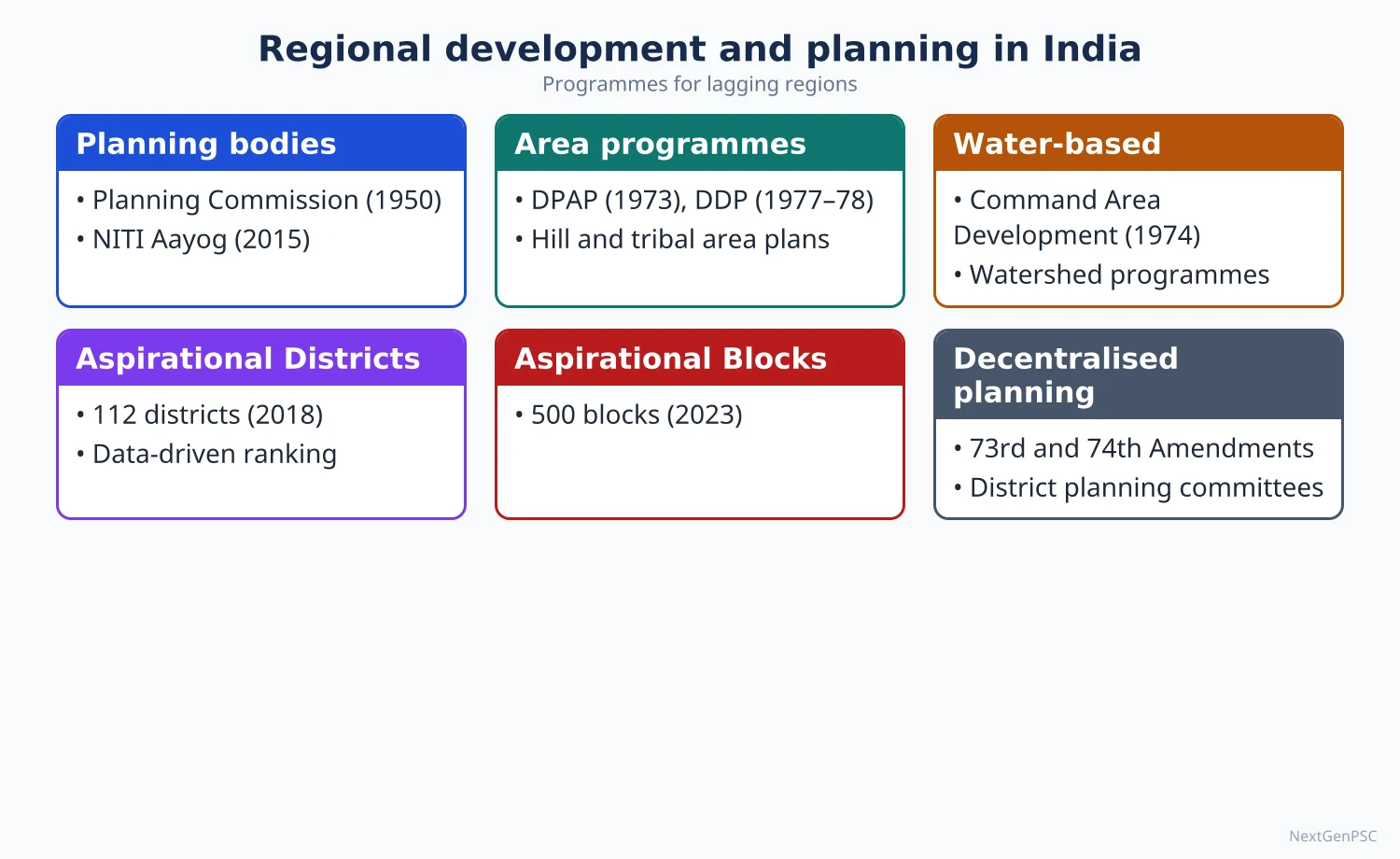
India plans separately for problem regions whose physical setting or history holds them back: backward districts, hot and cold deserts, drought-prone belts, hills, tribal areas and islands. Area programmes began in the 1970s (DPAP 1973–74, DDP 1977–78, Hill Area Development and the Tribal Sub-Plan in the Fifth Plan) and today include the Aspirational Districts Programme (2018, 112 districts), the Aspirational Blocks Programme (2023, 500 blocks), PM-JANMAN (2023), the Vibrant Villages Programme and island plans under the Island Development Agency (2017), including the debated Great Nicobar project.
In simple words
Some parts of India start the race with heavy bags: deserts with little rain, steep hills, remote tribal forests and far-off islands.
Area development gives each such region a plan made for its own problem, like special coaching designed for a weak subject.
It matters because one national scheme cannot fit both the Thar desert and the Andaman Islands, and problem-area planning reduces regional disparity.
UPSC asks you to evaluate these programmes with named regions and current schemes.
1. Concepts and definitions
Backward area: an area that lags behind the national average on income, infrastructure and human development; backwardness may be physical (desert, hill), historical (colonial neglect) or social (tribal isolation).
Problem region: a region with a specific physical or economic constraint that needs a tailored plan; the Sivaraman committee report (1981) used this problem-area approach.
Drought-prone area: an area where rainfall is low and highly variable, so crop failure is frequent; the India Meteorological Department treats a seasonal deficit of more than 20 percent of normal rainfall as deficient.
Arid and semi-arid zones: the hot arid zone covers western Rajasthan, Kachchh and parts of Haryana and Punjab; the cold arid zone covers Ladakh and Lahaul-Spiti; semi-arid zones lie in the rain-shadow of the Western Ghats and central India.
Tribal area: areas notified as Scheduled Areas under the Fifth Schedule (central and peninsular India) or governed by the Sixth Schedule (Assam, Meghalaya, Tripura, Mizoram).
2. Backward area development
Identification: the B.D. Pande group (1968–69) listed industrially backward districts; the Central Investment Subsidy Scheme (1971) and concessional finance followed.
Backward Regions Grant Fund (2006–07): untied funds to about 250 backward districts (later 272) for district plans through panchayats; discontinued from 2015–16.
Special packages: the Revised Long-Term Action Plan for the KBK region (Kalahandi-Balangir-Koraput, Odisha, from 1998–99) and the Bundelkhand package (2009) for districts of Uttar Pradesh and Madhya Pradesh.
Aspirational Districts Programme (January 2018): 112 districts ranked monthly on 49 indicators in five themes: health and nutrition (30 percent), education (30), agriculture and water (20), financial inclusion and skills (10) and basic infrastructure (10) (NITI Aayog).
Aspirational Blocks Programme (January 2023): 500 blocks in 329 districts across 27 states and 4 Union Territories, tracked on about 40 key indicators (Government reply in Parliament, 2025); Sampoornata Abhiyan (2024) pushed saturation of selected indicators.
Method: convergence of schemes, collaboration of centre, state and district officers, and competition through a public dashboard; it applies 'competitive federalism' at district level.
Debate: supporters cite gains in institutional deliveries and immunisation; critics argue that ranking focuses on measurable inputs and does not tackle structural causes such as land, irrigation and industry (debated).
3. Desert development
Desert Development Programme (1977–78): covered hot desert areas of Rajasthan, Gujarat and Haryana and cold desert areas of Ladakh and Himachal Pradesh; aims were to check desertification and restore ecological balance.
Process of desertification in Thar: overgrazing, removal of shrubs for fuel, cultivation of marginal land and strong winds move sand dunes onto fields and roads.
Measures: sand dune stabilisation with grasses such as sewan, shelterbelts along canals and roads, silvi-pasture, and water harvesting through tankas, kunds and khadins.
Indira Gandhi Canal: begun in 1958, fed from the Harike barrage on the Sutlej-Beas, it brought irrigation to western Rajasthan but also waterlogging, salinity and a shift away from pastoral life.
Research support: the Central Arid Zone Research Institute (CAZRI, Jodhpur, 1959) develops dryland farming, dune fixing and arid horticulture.
Cold desert: Ladakh and Lahaul-Spiti use glacier melt channels, artificial ice reservoirs (ice stupas in Ladakh) and greenhouse farming; tourism and solar power are new options.
4. Drought-prone area development
DPAP (1973–74): grew out of the Rural Works Programme (1970–71); it used watershed works, afforestation, dryland farming and livestock development in drought-prone districts.
Drought belts of India: western Rajasthan and Kachchh; the rain-shadow belt of Maharashtra, Karnataka and Telangana; Rayalaseema (Andhra Pradesh); Bundelkhand; parts of Tamil Nadu and Odisha (Kalahandi).
Review and merger: the Hanumantha Rao Committee (1994) recommended a participatory watershed approach; DPAP and DDP were merged into IWMP (2009–10) and then into PMKSY-WDC (2015–16).
Institutions: the National Rainfed Area Authority (2006) advises on rainfed farming; the Manual for Drought Management (2016, updated 2020) sets indicators for declaring drought.
Crop and water strategy: millets and pulses suited to dry areas, crop insurance (PM Fasal Bima Yojana, 2016), micro-irrigation and fodder banks.
5. Hill area development
Hill Area Development Programme (Fifth Plan, 1974–75): for designated hill areas outside the hill states, such as the Nilgiris (Tamil Nadu), Darjeeling (West Bengal) and parts of Assam; the Western Ghats Development Programme (1974–75) covered the Ghats taluks.
Special Category status: under the Gadgil formula (1969), hilly terrain, low density, a large tribal share and strategic borders made states such as those of the Northeast, Himachal Pradesh and Jammu and Kashmir eligible for liberal central assistance; the Fourteenth Finance Commission (2015) no longer distinguished them in tax devolution.
North-East institutions: North Eastern Council (statutory, 1971), Ministry of Development of North Eastern Region (department 2001), and PM-DevINE (Budget 2022–23) for infrastructure and social projects.
Hill problems: fragile slopes, landslides, small fragmented holdings, shifting cultivation (jhum) in the Northeast, out-migration from Uttarakhand hill villages and poor connectivity.
Hill strategies: horticulture (apple in Himachal Pradesh), terrace farming, eco-tourism, small hydropower, and the National Mission for Sustaining the Himalayan Ecosystem (under the National Action Plan on Climate Change, 2008).
Border villages: the Vibrant Villages Programme-I (approved 15 February 2023) covers 46 blocks in 19 districts of Arunachal Pradesh, Himachal Pradesh, Sikkim, Uttarakhand and Ladakh along the northern border, with 662 villages in the first phase.
VVP-II (approved April 2025): 6,839 crore rupees for border villages on other land borders across 17 states and Union Territories (Cabinet decision, 2025).
Debate: road widening and hydropower in the Himalaya (for example the Char Dham road project and the 2023 subsidence at Joshimath) raise questions about carrying capacity (debated).
6. Tribal area development
Tribal Sub-Plan (Fifth Plan, 1974–75): a share of plan funds earmarked for tribal areas in proportion to the tribal population; delivered through Integrated Tribal Development Projects (ITDPs), MADA pockets and clusters.
Current form: the sub-plan is now known as the Development Action Plan for Scheduled Tribes, with about 40 central ministries earmarking funds.
PVTGs: 75 Particularly Vulnerable Tribal Groups; PM-JANMAN (launched 15 November 2023, about 24,104 crore rupees) provides housing, roads, water and health to PVTG habitations.
PM-JUGA (2024): the Dharti Aaba Janjatiya Gram Utkarsh Abhiyan (approved September 2024, about 79,156 crore rupees) targets about 63,000 tribal-majority villages through scheme convergence.
Legal protection: Fifth and Sixth Schedules, PESA (1996) and the Forest Rights Act (2006) protect land, forest and self-governance rights.
Problems: land alienation, displacement by mines and dams (for example in the Chota Nagpur plateau and Bastar), indebtedness, malnutrition and left-wing extremism in some tribal districts.
Livelihood examples: Van Dhan Vikas Kendras (2018) for value addition to minor forest produce; Eklavya Model Residential Schools for tribal education.
7. Island territories
Two groups: Andaman and Nicobar Islands in the Bay of Bengal (about 572 islands and islets) and Lakshadweep in the Arabian Sea (36 islands, 10 inhabited); both are Union Territories.
Island problems: isolation and high transport cost, scarce fresh water, small land area, vulnerability to cyclones, tsunamis (2004) and sea-level rise, and fragile coral and forest ecosystems.
Island Development Agency (1 June 2017): chaired by the Union Home Minister with NITI Aayog support; 10 islands were picked for the first phase, and by 2018 about 26 islands (16 in Andaman and Nicobar, 10 in Lakshadweep) were listed for holistic development.
Connectivity: the Chennai-Andaman submarine optical fibre cable (inaugurated August 2020) and the Kochi-Lakshadweep submarine cable (January 2024) brought high-speed internet.
Great Nicobar project (approved 2021): a transshipment port at Galathea Bay, an international airport, a township and a gas-and-solar power plant, at an often-cited cost of about 72,000 crore rupees; it needs diversion of roughly 130 sq km of forest.
Great Nicobar debate: supporters stress strategic location near the Malacca Strait and the East-West shipping route; critics point to the Shompen (a PVTG), leatherback turtle nesting, coral reefs, the Great Nicobar Biosphere Reserve and high seismic risk (debated).
Regulation: the Island Coastal Regulation Zone Notification (2019) and Integrated Island Management Plans govern construction near the shore.
Lakshadweep strategy: eco-tourism with carrying-capacity limits, solar power to replace diesel, desalination (low-temperature thermal desalination plants at Kavaratti and other islands) and fisheries such as tuna.
8. Maps and diagrams to draw
Map 1: India outline shading drought-prone belts (western Rajasthan, Kachchh, Marathwada, north Karnataka, Rayalaseema, Bundelkhand) and the hot and cold deserts.
Map 2: mark Fifth Schedule states (central belt) and Sixth Schedule states (Northeast), with PVTG examples such as Shompen (Great Nicobar) and Baiga (Madhya Pradesh).
Map 3: inset of Andaman and Nicobar and Lakshadweep marking Port Blair, Galathea Bay, Kavaratti and Minicoy, with the 10° Channel between Little Andaman and Car Nicobar.
Diagram: a matrix of region types (desert, drought, hill, tribal, island) against their main constraint and main remedy.
9. Using it in the exam
10 marks (150 words): define the problem region, name the programme with year, give two measures and one example.
15 marks (200 words): add a map and a current scheme with figures (Aspirational Blocks, PM-JANMAN, WDC 2.0).
20 marks (250 words): compare two or more problem regions, evaluate programmes, include the Great Nicobar debate for islands, and suggest region-specific strategies.
Keywords: problem-area approach, convergence, carrying capacity, desertification, Tribal Sub-Plan, PVTG, island ecology, competitive federalism.
Attributed idea: the National Committee on the Development of Backward Areas (B. Sivaraman, 1981) argued that each type of backward area needs a strategy fitted to its specific constraints (paraphrase).
| Region type | Programme and year | Main measures | Example areas |
|---|---|---|---|
| Drought-prone | DPAP, 1973–74; now PMKSY-WDC | Watershed works, dryland farming, fodder | Marathwada, Rayalaseema, Bundelkhand |
| Desert | DDP, 1977–78; now PMKSY-WDC | Dune fixing, shelterbelts, water harvesting | Western Rajasthan, Kachchh, Ladakh |
| Hill | HADP and Western Ghats programme, 1974–75 | Terracing, horticulture, eco-tourism | Nilgiris, Darjeeling, Western Ghats taluks |
| Tribal | Tribal Sub-Plan, 1974–75; PM-JANMAN, 2023; PM-JUGA, 2024 | Earmarked funds, PVTG habitations, rights under FRA | Bastar, Chota Nagpur, Northeast |
| Backward district | BRGF, 2006–07; Aspirational Districts, 2018; Aspirational Blocks, 2023 | Convergence, ranking on indicators | 112 districts; 500 blocks |
| Border village | Vibrant Villages Programme, 2023; VVP-II, 2025 | Roads, livelihoods, tourism, connectivity | Northern border blocks of Arunachal to Ladakh |
| Island | Island Development Agency, 2017 | Eco-tourism, connectivity, ports, renewable energy | Andaman and Nicobar; Lakshadweep |
| Theme | Weight |
|---|---|
| Health and nutrition | 30 percent |
| Education | 30 percent |
| Agriculture and water resources | 20 percent |
| Financial inclusion and skill development | 10 percent |
| Basic infrastructure | 10 percent |
Mains points
- Name the region precisely (Marathwada, Rayalaseema, Thar, Kalahandi, Great Nicobar) instead of writing 'backward areas' in general.
- Match each problem region to its constraint and its tailored remedy; a comparative table earns marks in 15- and 20-mark answers.
- Use current schemes with years: Aspirational Districts (2018), Aspirational Blocks (2023), PM-JANMAN (2023), PM-JUGA (2024), Vibrant Villages (2023, VVP-II 2025).
- For island questions balance strategic and economic gains against tribal rights, biodiversity and seismic risk; mark the Great Nicobar debate as debated.
- Mention that DPAP and DDP were merged into watershed programmes; writing about them as separate current schemes is outdated.
- Draw at least one map: drought belts, Scheduled Areas or an island inset.
Did you know?
- The 10° Channel separates the Andaman group from the Nicobar group, while the 8° Channel separates Minicoy from the Maldives.
- Memory trick for 1970s area programmes: 'Dry Deserts Have Tribes' gives DPAP (1973–74), DDP (1977–78), HADP and Tribal Sub-Plan (Fifth Plan).
UPSC Previous Year Questions: Regional Development and Planning in India
From 2014 to 2026 UPSC asked 31 question parts worth 455 marks from this chapter (10 parts of 10 marks, 13 of 15 marks and 8 of 20 marks), all in Paper II. The most-asked areas are backward, hill, tribal, drought-prone and island area development (15 parts), Panchayati Raj and decentralised planning (8 parts) and command area development and watershed management (7 parts). Every question below has a model answer written to the UPSC word limit, with a map or diagram.
In simple words
Read the question and write your own answer first, in about 150 words for 10 marks, 200 for 15 and 250 for 20, with one map or diagram.
Then compare it with the model answer: did you define the key term, name schemes with their years, give Indian examples and data with a source?
Note what you missed in your notebook and revise the matching topic in the notes before trying the next question.
1. Regional Planning Experience, Five Year Plans and Multi-level Planning
Example 1 (UPSC 2015, 20 marks): Discuss the concept of multi-level planning as practised in India, and explain the implications of 73rd and 74th Constitutional Amendments in this respect.
Paper and question: Paper II, Q8(a)
Approach: Define multi-level planning and trace its levels and committees in India, then explain how the 73rd and 74th Amendments gave it a constitutional base; end with gaps and a way forward. Draw a tier diagram.
Multi-level planning is the preparation of plans at several nested spatial levels (national, state, district, block and village) so that each level plans for what it knows best and the plans are integrated upward and downward.
Evolution in India: the first Five Year Plans were centralised and sectoral. Community Development (1952) created the block; the Balwantray Mehta Committee (1957) recommended a three-tier Panchayati Raj, first adopted in Nagaur, Rajasthan (1959). The Dantwala Working Group (1978) on block-level planning and the Hanumantha Rao Working Group (1984) on district planning argued for planning from below, but without assured funds plans stayed top-down.
Implications of the 73rd Amendment (1992): it made the Gram Sabha and three-tier panchayats constitutional, with five-year terms, State Election Commissions and State Finance Commissions. Article 243G asks panchayats to prepare plans for economic development and social justice on the 29 subjects of the Eleventh Schedule.
Implications of the 74th Amendment (1992): it created municipalities with 18 subjects in the Twelfth Schedule, including urban planning. Article 243ZD requires a District Planning Committee to consolidate panchayat and municipal plans into a draft district plan, and Article 243ZE a Metropolitan Planning Committee for cities of over 10 lakh people.
Outcomes: Kerala's People's Plan Campaign (1996) devolved about a third of state plan funds to local bodies; since 2015 every gram panchayat prepares a Gram Panchayat Development Plan (GPDP).
Gaps: devolution of funds, functions and functionaries is uneven; many District Planning Committees exist only on paper, and centrally sponsored schemes still dominate local budgets.
Diagram: a pyramid of five tiers (Union/NITI Aayog, State, District Planning Committee, Block/Panchayat Samiti, Gram Panchayat and Gram Sabha) with downward arrows for funds and guidelines and upward arrows for plans.
Multi-level planning in India now has a constitutional skeleton; real devolution, functional DPCs and spatial data from GIS can give it substance and bottom-up integration.
2. Integrated Rural Development, Panchayati Raj and Decentralised Planning
Example 2 (UPSC 2026, 10 marks): Discuss how Panchayati Raj institutions play a crucial role in the empowerment of women in India.
Paper and question: Paper II, Q5(c)
Approach: Show how reservation and participation in Panchayati Raj institutions empower women politically, socially and economically, with data and examples, and note limits such as proxy representation. Add a map of states with 50 percent reservation.
The 73rd Amendment (1992) reserved at least one-third of panchayat seats and chairperson posts for women (Article 243D); more than 20 states have since raised this to 50 percent reservation, Bihar being the first in 2006.
Political empowerment: about 14 lakh women, nearly 46 percent of the roughly 31 lakh elected panchayat representatives, sit in local government (Ministry of Panchayati Raj). This is a training ground for leadership at higher levels.
Changing priorities: a study of West Bengal and Rajasthan villages by Chattopadhyay and Duflo (2004) found that women pradhans invested more in drinking water and roads, the needs women had voiced.
Economic and social gains: panchayats work with self-help groups of DAY-NRLM and Kudumbashree (Kerala) on livelihoods, nutrition and sanitation, raising women's voice in the household and village.
Limits: 'sarpanch-pati' or proxy rule by male relatives, low literacy, caste hierarchy and short rotation of reserved seats.
Map: India outline shading the states that reserve 50 percent of panchayat seats for women, with Bihar, Kerala and Rajasthan labelled.
With capacity building and gender budgeting, PRIs can turn numerical presence into real decision-making power.
Example 3 (UPSC 2024, 15 marks): The 73rd Constitutional Amendment Act devolved functions, finances and functionaries for planning of rural areas in India. Discuss the major achievements with examples.
Paper and question: Paper II, Q7(b)
Approach: Explain the three Fs devolved by the 73rd Amendment, then discuss achievements under each with named examples and data, and close with remaining gaps. Draw a flow chart of the GPDP cycle.
The 73rd Constitutional Amendment Act (1992, in force from April 1993) created a uniform three-tier Panchayati Raj and asked states to devolve the three Fs: functions (29 subjects of the Eleventh Schedule), finances and functionaries, so that rural areas could plan for themselves.
Functions: about 2.5 lakh gram panchayats now prepare an annual Gram Panchayat Development Plan through the People's Plan Campaign 'Sabki Yojana Sabka Vikas', held every year from 2 October since 2018. Kerala transferred health centres, schools and agriculture offices to local bodies.
Finances: the Fifteenth Finance Commission allotted about 2.36 lakh crore rupees to rural local bodies for 2021–26, part tied to drinking water and sanitation. Funds now flow directly to panchayat accounts and are tracked on eGramSwaraj (2020).
Functionaries: states such as Kerala and Karnataka placed line-department staff under panchayats; Maharashtra's Zilla Parishads run primary schools and health centres.
Social achievements: nearly 46 percent of elected representatives are women, and reserved seats brought Scheduled Castes and Tribes into local power; PESA (1996) extended Gram Sabha powers to Fifth Schedule areas, and with the Forest Rights Act (2006) Mendha-Lekha (Gadchiroli) won community rights over bamboo.
Diagram: flow chart of the GPDP cycle: situation analysis, Gram Sabha prioritisation, plan approval, upload on eGramSwaraj, execution, social audit.
Gaps: devolution remains uneven across states, own-source revenue is small, and staff shortages persist. Even so, the Act has made the panchayat a real planning unit in states that devolved sincerely.
Example 4 (UPSC 2022, 10 marks): Can the Panchayat Raj institutions play a role in grassroot level planning in India? If yes, discuss how.
Paper and question: Paper II, Q5(b)
Approach: Answer 'yes' and show how PRIs plan at the grassroots: constitutional mandate, GPDP process, local knowledge and convergence, with examples; note constraints briefly. Draw the GPDP flow chart.
Yes. Article 243G empowers panchayats to prepare plans for economic development and social justice, making them the base of grassroot planning.
How: (i) the Gram Sabha identifies needs through participatory rural appraisal, resource mapping and transect walks; (ii) the gram panchayat prepares the annual Gram Panchayat Development Plan (GPDP), aligned since 2022 with nine themes of the localised Sustainable Development Goals; (iii) the plan converges Finance Commission grants with MGNREGA, Swachh Bharat, Jal Jeevan Mission and NRLM funds; (iv) the block and district panchayats consolidate plans for the District Planning Committee.
Examples: Kerala's People's Plan Campaign (1996) showed that local bodies can plan and implement a third of state plan funds; Hiware Bazar (Ahmednagar) used Gram Sabha rules to regenerate water and grazing land; under PESA and the Forest Rights Act, Gram Sabhas in Gadchiroli manage bamboo sales.
Diagram: flow chart: Gram Sabha needs assessment → GPDP draft → approval → eGramSwaraj upload → execution → social audit.
Constraints: scheme-tied funds, weak technical staff and elite capture. With trained planners, untied funds and GIS-based village maps, PRIs can make planning truly bottom-up.
Example 5 (UPSC 2021, 20 marks): Critically examine how Panchayati Raj system is catalyst in decentralized planning in India.
Paper and question: Paper II, Q7(a)
Approach: Critically examine: first show the ways PRIs catalyse decentralised planning (mandate, GPDP, finance, examples), then the limits (three Fs gap, scheme dominance, elite capture, weak DPCs), and end with a balanced verdict. Draw a tier diagram.
Decentralised planning transfers the power to identify needs, set priorities and allocate resources to elected local bodies. The Balwantray Mehta Committee (1957) called it democratic decentralisation; the 73rd Amendment (1992) made the three-tier Panchayati Raj its constitutional instrument.
As a catalyst: (i) Article 243G and the Eleventh Schedule's 29 subjects give panchayats a planning mandate; (ii) every gram panchayat prepares a GPDP each year, and block and district panchayats prepare their own plans since 2019; (iii) the Fourteenth and Fifteenth Finance Commissions sent large grants directly to panchayats (about 2.36 lakh crore rupees for 2021–26); (iv) the Gram Sabha brings local knowledge and social audit, as in MGNREGA.
Successes: Kerala's People's Plan Campaign (1996) and Karnataka's devolution show what is possible; Ralegan Siddhi and Hiware Bazar in Maharashtra planned watersheds through Gram Sabhas; PESA (1996) and the Forest Rights Act (2006) let tribal Gram Sabhas in Gadchiroli control minor forest produce.
Limits: devolution of functions, funds and functionaries is uneven, and in many states panchayats remain implementing agents of centrally sponsored schemes with fixed guidelines; own-source revenue is tiny; District Planning Committees under Article 243ZD are often inactive; elite and male proxy capture weakens participation; technical capacity for spatial planning is low.
Regional contrast: devolution is deep in Kerala, Karnataka and Tamil Nadu but shallow in several northern and northeastern states, while Sixth Schedule areas use district councils instead of panchayats.
Diagram: three-tier pyramid (Zila Parishad, Panchayat Samiti, Gram Panchayat with the Gram Sabha at the base) feeding the District Planning Committee, with arrows for plans upward and funds downward.
PRIs are therefore a necessary but not yet sufficient catalyst. Untied funds, a cadre of local planners, active DPCs and GIS-based village plans would turn formal decentralisation into real bottom-up planning.
Example 6 (UPSC 2020, 10 marks): The success of Panchayati Raj depends upon meaningful participation of people at grassroot level. Examine.
Paper and question: Paper II, Q5(a)
Approach: Examine why people's participation decides the success of Panchayati Raj, using the Gram Sabha, social audit and named examples, and note what limits participation. Add a map of model villages.
Panchayati Raj is meant to be democracy at the doorstep; its core body is the Gram Sabha (Article 243A), the assembly of all adult voters of a village. Without active participation, panchayats become mere implementing offices.
Why participation matters: people know their own needs and resources; their presence in the Gram Sabha sets priorities in the GPDP, checks corruption through social audit (mandatory under MGNREGA since 2005) and builds ownership, so assets such as check dams are maintained.
Evidence: Hiware Bazar and Ralegan Siddhi (Maharashtra) transformed water and farming through Gram Sabha decisions on grazing and water use; Kerala's People's Plan Campaign (1996) involved lakhs of people in ward sabhas; Mendha-Lekha (Gadchiroli) used the Gram Sabha to secure forest rights.
Barriers: low Gram Sabha attendance, dominance of landed castes, proxy representation of women, lack of information and scheme-driven agendas.
Map: India outline marking Hiware Bazar, Ralegan Siddhi, Mendha-Lekha, and Kerala as models of participatory panchayats.
Hence success depends on participation; ward and Mahila Sabhas, transparency on eGramSwaraj and capacity building can deepen it.
Example 7 (UPSC 2018, 10 marks): Examine the role of people's participation in successful decentralised planning in India.
Paper and question: Paper II, Q5(d)
Approach: Explain how people's participation makes decentralised planning succeed at each stage (needs, plan, implementation, monitoring) with Indian examples and institutional channels, then note barriers. Draw a participation cycle.
Decentralised planning succeeds only when the people for whom plans are made also make them; participation turns plans from official documents into community commitments.
Role at each stage: in needs assessment, participatory rural appraisal and resource maps reveal local priorities; in plan-making, the Gram Sabha ranks works in the GPDP; in implementation, user groups and self-help groups contribute labour and money; in monitoring, social audit and community scorecards keep officials accountable.
Indian examples: Kerala's People's Plan Campaign (1996); watershed committees under the Hanumantha Rao Committee guidelines (1995), as in Sukhomajri (Haryana) and Ralegan Siddhi; Joint Forest Management (1990), which made villagers partners in forest protection; Kudumbashree (Kerala) linking women's groups to panchayats.
Barriers: elite capture, social hierarchy, low awareness and top-down schemes.
Diagram: a circular participation cycle: needs assessment → Gram Sabha prioritisation → plan → community implementation → social audit → back to needs.
Participation is thus the engine of decentralised planning; information, ward sabhas and capacity building sustain it.
Example 8 (UPSC 2017, 20 marks): "An effective three-tier Panchayat Raj System will strengthen the bottom-up approach to multilevel planning in India." Explain.
Paper and question: Paper II, Q3(a)
Approach: Explain the bottom-up approach and multilevel planning, show how each Panchayat tier contributes and why effectiveness (three Fs, DPCs, participation) is the condition, with examples. Draw the three-tier diagram.
In a bottom-up approach, plans begin with the needs identified by people at the lowest level and are aggregated upward, unlike the top-down sectoral plans of India's early Five Year Plans. Multilevel planning nests these plans from village to block, district, state and nation.
Role of each tier: the Gram Panchayat and Gram Sabha identify needs and prepare the GPDP for drinking water, roads, sanitation and livelihoods; the Panchayat Samiti (block) plans for works beyond one village, such as minor irrigation and secondary roads, and gives technical support; the Zila Parishad integrates block plans with district sectors like health and agriculture, and the District Planning Committee (Article 243ZD) consolidates rural and urban plans into the district plan that feeds the state plan.
Why 'effective' matters: the Dantwala (1978) and Hanumantha Rao (1984) working groups had recommended block and district planning, but without funds and staff these remained recommendations. The 73rd Amendment (1992) gave tiers constitutional status, and the Fourteenth and Fifteenth Finance Commission grants gave them money; where states also transferred functions and staff, as in Kerala and Karnataka, bottom-up planning became real.
Examples: Kerala's People's Plan Campaign (1996) produced plans from ward sabhas upward; Ralegan Siddhi's watershed plan grew from village needs into a district model; the Aspirational Blocks Programme (2023) now focuses on the block as a planning unit.
Diagram: three-tier pyramid with the Gram Sabha at the base, Gram Panchayat, Panchayat Samiti and Zila Parishad above, feeding the District Planning Committee and state plan; arrows show plans moving up and funds moving down.
Constraints: uneven devolution, weak DPCs, scheme-tied funds and elite capture can make the system top-down in practice.
The statement holds true, provided the three tiers are genuinely empowered; then local plans become the building blocks of state and national plans.
Example 9 (UPSC 2015, 20 marks): Decentralized planning through the strengthening of the Panchayat system is the focus of planning in India in recent times. Suggest a blueprint for an integrated regional development plan.
Paper and question: Paper II, Q6(a)
Approach: Briefly justify decentralised planning, then suggest a step-by-step blueprint for an integrated regional (district) development plan: delineation, data, sectoral and spatial components, institutions, finance and monitoring. Draw a hierarchy-of-centres sketch.
Since the 73rd Amendment (1992) and the GPDP campaign (2018 onward), Indian planning has shifted from sectoral to decentralised planning. An integrated regional plan must join these village plans into a spatially coherent district or block plan.
Step 1, planning region: take the district or a cluster of blocks, and use watersheds as sub-units for land and water planning.
Step 2, resource and needs inventory: a GIS database of land use, soils, groundwater, population (Census), infrastructure and the Aspirational District and Block indicators; participatory appraisal in every Gram Sabha.
Step 3, spatial framework: identify a hierarchy of growth centres (village service centres, growth points, block towns, district town) on the lines of R.P. Misra's growth-foci approach, and plan roads (PMGSY), markets and services to link them.
Step 4, sectoral components: agriculture and allied activities by agro-climatic zone; watershed and irrigation (PMKSY); non-farm work through SHGs and clusters; health, education and skill centres; special components for SC, ST, hill or drought-prone pockets.
Step 5, institutions and finance: GPDPs consolidated by block and district panchayats and the District Planning Committee; converge Finance Commission grants, MGNREGA, NRLM, Jal Jeevan Mission and state funds.
Step 6, monitoring: outcome indicators, social audit, real-time dashboards and mid-term revision.
Diagram: a district map showing a nested hierarchy of centres (district town, block towns, growth points, service villages) linked by roads, with watershed boundaries in the background.
Kerala's People's Plan and the Rurban Mission clusters show that such a blueprint works when people, data and money meet at the same spatial level.
3. Command Area Development and Watershed Management
Example 10 (UPSC 2025, 10 marks): "Watershed is the most appropriate spatial unit for planning." Comment.
Paper and question: Paper II, Q5(c)
Approach: Comment by defining a watershed, giving reasons why it is an ideal planning unit (natural, integrated, participatory), with Indian examples, and noting limits. Draw a ridge-to-valley sketch.
A watershed is the area drained by a stream to a common outlet, bounded by a ridge line; it ranges from basins to micro-watersheds of a few hundred hectares.
Why the most appropriate unit: (i) it is a natural hydrological unit, so runoff, soil loss and groundwater recharge can be measured and managed together; (ii) it links land, water, forest, livestock and people, enabling integrated planning; (iii) treatment follows the logical ridge-to-valley sequence: trenches and plantations on the ridge, bunds on slopes, check dams in drainage lines; (iv) its small size suits community participation.
Indian experience: Sukhomajri (Haryana) and Ralegan Siddhi (Maharashtra) showed rising water tables and incomes; the Hanumantha Rao Committee (1994) made watersheds the unit of DPAP and DDP, and WDC-PMKSY 2.0 (2021–26) targets about 49.5 lakh ha.
Diagram: cross-section of a micro-watershed from ridge to valley showing staggered trenches, contour bunds, gully plugs, check dam and farm pond.
Limits: watershed boundaries do not match administrative units, benefits go mainly to landowners in the valley, and urban or industrial planning needs other units.
So the watershed is ideal for natural-resource and rural planning, best combined with panchayat and district units.
Example 11 (UPSC 2023, 15 marks): Critically examine the ecological and economic impact of Indira Gandhi Canal Command Area development.
Paper and question: Paper II, Q7(c)
Approach: Introduce the Indira Gandhi Canal and its command, then critically weigh economic gains against ecological costs with examples, ending with a balanced verdict. Draw a map of the canal.
The Indira Gandhi Canal (Rajasthan Canal until 1984), begun in 1958, takes Sutlej-Beas water from the Harike barrage in Punjab into the Thar desert. Its Rajasthan feeder (about 204 km) and main canal (about 445 km) serve a command in Sri Ganganagar, Hanumangarh, Bikaner, Jaisalmer, Barmer, Jodhpur and Churu districts; command area development began here in the mid-1970s.
Economic impact: irrigation turned pastoral desert into farmland growing wheat, mustard, cotton, groundnut and guar; Sri Ganganagar and Hanumangarh became a granary of Rajasthan; drinking water reached towns and villages as far as Jaisalmer and Barmer; colonisation settled landless families, and mandis, roads and agro-processing grew.
Ecological impact, positive: canal-side shelter belts and pasture development checked shifting sand and increased green cover and soil moisture.
Ecological impact, negative: seepage and over-irrigation caused waterlogging and salinity in parts of Stage I; introduced species such as Prosopis juliflora spread; native desert grasslands shrank, harming wildlife like the Great Indian Bustard; malaria incidence rose with standing water.
Social and economic concerns: benefits are uneven between head and tail reaches, traditional pastoralism declined, and water supply depends on Punjab's releases.
Map: outline of western Rajasthan showing Harike barrage, the feeder and main canal ending near Mohangarh (Jaisalmer), lift canals, and the command districts with waterlogged pockets shaded.
Overall the project is an economic success with real ecological costs; drip and sprinkler irrigation, drainage, crop zoning away from water-intensive crops and conservation of desert habitats are the way forward.
Example 12 (UPSC 2021, 10 marks): Discuss the role of watershed management for soil and water conservation in hilly regions of India.
Paper and question: Paper II, Q5(c)
Approach: Explain why hilly regions need watershed management, then list the soil and water conservation measures and named Indian hill examples, ending with gaps. Draw a hill-slope treatment sketch.
Steep slopes, heavy monsoon rain, deforestation and fragile rocks make the Himalaya, Northeast and Western Ghats prone to soil erosion, landslides and rapid runoff, while springs that supply villages are drying. Watershed management treats the whole slope as one unit.
Measures: afforestation and pasture on the ridge; contour trenches and bench terraces on slopes; gully plugs and check dams in streams; spring-shed recharge pits; agroforestry and controlled grazing.
Indian examples: Sukhomajri (Shivaliks, Haryana) cut silt in Sukhna Lake through community check dams; the Uttarakhand Decentralised Watershed Development Project (Gramya) and Himachal's Mid-Himalayan Watershed Project improved fodder and water; Sikkim's Dhara Vikas (2008) recharged springs; the zabo system of Kikruma (Nagaland) links forest catchment, ponds and terraced fields.
Diagram: hill slope showing forest on the ridge, contour trenches, bench terraces, a check dam in the stream and a recharged spring below.
Gaps: scattered land holdings, out-migration and weak maintenance; NITI Aayog (2018) noted that many Himalayan springs are drying. Springshed mapping and community institutions are needed.
Example 13 (UPSC 2021, 15 marks): Discuss the Command Area Development Programme and its impact on eliminating regional inequalities in India.
Paper and question: Paper II, Q8(b)
Approach: Explain the objectives and components of the Command Area Development Programme and its evolution, then assess whether it reduced or widened regional inequalities with examples. Draw a map of major commands.
The Command Area Development Programme (CADP), launched in 1974–75, aimed to close the gap between irrigation potential created and utilised in major and medium projects by integrating on-farm works with agriculture. It became the Command Area Development and Water Management Programme (2004), was folded into PMKSY (2015–16) and in April 2025 was followed by the Modernisation of Command Area Development and Water Management (M-CADWM) sub-scheme.
Components: field channels and drains, land levelling, warabandi (rotational water supply), conjunctive use of surface and groundwater, reclamation of waterlogged land, and water users' associations under participatory irrigation management.
Positive impact on inequality: it extended irrigation to drier, poorer regions, such as the Indira Gandhi Canal command in western Rajasthan, Tungabhadra and Upper Krishna in north Karnataka, Nagarjuna Sagar in Andhra Pradesh and Chambal in Madhya Pradesh and Rajasthan, raising yields and incomes there.
Limits: funds and benefits concentrated in already irrigated states and in head reaches, while tail-end farmers got little water; waterlogging and salinity hit commands such as Indira Gandhi Canal, Tawa and Sharda Sahayak; within commands, large landholders gained more than marginal farmers.
Map: India outline marking major commands: Indira Gandhi Canal, Chambal, Tawa, Sharda Sahayak, Nagarjuna Sagar and Tungabhadra.
Hence CADP narrowed some inter-regional gaps but widened intra-command inequality; equitable water allocation, micro-irrigation and strong water users' associations are needed to make it a tool of balanced development.
Example 14 (UPSC 2019, 15 marks): Discuss how watershed management has become a tool in eradication of rural poverty in India.
Paper and question: Paper II, Q2(c)
Approach: Show the pathways through which watershed management reduces rural poverty (water, productivity, employment, livestock, equity components), with evidence and examples, and note limits. Draw a flow diagram of the poverty pathway.
About half of India's net sown area is rainfed, and poverty is concentrated in these dry and degraded lands. Watershed management, the integrated treatment of land and water in a drainage unit, has moved from soil conservation to a livelihood tool.
Pathways out of poverty: (i) water harvesting raises groundwater, enabling a second crop and higher cropping intensity; (ii) reduced erosion and better moisture raise yields of pulses, oilseeds and millets; (iii) fodder from treated commons supports dairy, important for landless households; (iv) construction work provides wage employment, now converged with MGNREGA; (v) the Common Guidelines (2008) reserved part of project funds for livelihoods of assetless households and women's self-help groups.
Evidence: Ralegan Siddhi and Hiware Bazar (Ahmednagar, Maharashtra) turned drought-hit villages into prosperous ones with reverse migration; ICRISAT's Kothapally watershed (Telangana) raised incomes; Sukhomajri (Haryana) shared water and grass rights among all households. An ICRISAT review of over 600 watershed projects found average returns of about two rupees for every rupee spent.
Diagram: flow diagram: watershed works → recharge and moisture → more crops, fodder and wage work → higher income and less migration.
Limits: benefits accrue mostly to landowners in the valley; landless and women gain less unless equity rules exist; maintenance fails after projects end.
WDC-PMKSY 2.0 (2021–26), with springshed and livelihood components, can make watersheds a stronger anti-poverty tool if equity and community ownership are built in.
Example 15 (UPSC 2015, 10 marks): Discuss the relationship of watershed approach to village level planning.
Paper and question: Paper II, Q1(d)
Approach: Explain the watershed approach and show how it fits village-level planning (scale, participation, convergence), with examples and the boundary mismatch problem. Draw a sketch of a watershed overlapping village boundaries.
The watershed approach plans land, water, vegetation and livestock together within a natural drainage unit, treating it from ridge to valley. Village-level planning, under Article 243G, is done by the Gram Panchayat through the GPDP.
Relationship: (i) scale: a micro-watershed of a few hundred hectares roughly matches one or two villages, so it is a natural unit for village plans; (ii) participation: watershed committees under the Gram Sabha, introduced by the Hanumantha Rao Committee guidelines (1995), make villagers planners; (iii) content: the watershed plan supplies the natural-resource component of the village plan, such as check dams, farm ponds and pasture; (iv) convergence: MGNREGA, PMKSY-WDC and Finance Commission grants fund these works through the panchayat.
Examples: Ralegan Siddhi and Hiware Bazar planned their entire village development around watershed works; Maharashtra's Jalyukt Shivar (2014–15) and Rajasthan's Mukhyamantri Jal Swavlamban Abhiyan (2016) used village-wise watershed plans.
Diagram: sketch of a micro-watershed whose ridge line cuts across two village boundaries, with treatment structures marked.
Issue: watershed and village boundaries rarely coincide, so cluster-level committees and GIS maps are needed to align the two.
Example 16 (UPSC 2014, 15 marks): Discuss the concept of Command Area Development and evaluate its success with reference to Indira Gandhi Canal.
Paper and question: Paper II, Q8(b)
Approach: Define the concept of Command Area Development and its components, then evaluate its success in the Indira Gandhi Canal command with gains and failures, ending with a verdict. Draw a map of the canal command.
Command Area Development (CAD) is the integrated development of the area irrigated by a canal project, so that water released at the outlet is used efficiently on farms. Launched nationally in 1974–75, it combines on-farm development (field channels, land levelling, drains), warabandi, conjunctive use of groundwater, crop planning, roads, markets and farmer participation.
Indira Gandhi Canal: begun in 1958 from the Harike barrage, it carries Sutlej-Beas water into the Thar through Sri Ganganagar, Hanumangarh, Bikaner, Jaisalmer and Barmer; a CAD authority was set up for it in the 1970s, and colonisation settled farmers on newly irrigated land.
Successes: desert pasture became farmland under wheat, mustard, cotton and gram; Stage I districts became Rajasthan's food bowl; lift schemes and pipelines brought drinking water to Bikaner, Jodhpur and Jaisalmer; shelter belts and sand-dune stabilisation slowed desertification; mandis, roads and agro-industries created non-farm jobs.
Failures: seepage from unlined channels and over-irrigation caused waterlogging and secondary salinity in parts of Stage I; Stage II progressed slowly; tail-end farmers received erratic water; desert ecology and pastoral livelihoods suffered, and malaria rose; water-intensive crops like rice and sugarcane spread against design norms.
Map: outline map of western Rajasthan showing Harike barrage, the Rajasthan feeder, the main canal to Mohangarh, lift canals and command districts, with waterlogged areas shaded.
Overall, CAD in the Indira Gandhi Canal is a qualified success: it transformed the economy of the Thar, but its ecological costs show that water management, drainage and crop discipline must accompany irrigation.
4. Backward, Desert, Drought-prone, Hill, Tribal Area and Island Development
Example 17 (UPSC 2026, 15 marks): Soil and water conservation are the major challenges in the development of hill areas of India. Explain.
Paper and question: Paper II, Q6(b)
Approach: Explain why soil and water conservation are the central challenges of hill development (physical causes, human pressures, consequences) with Indian examples, then the responses and a way forward. Draw a map of hill regions with hotspots.
India's hill areas, the Indian Himalayan Region, the Northeast hills and the Western Ghats, are fragile 'water towers' that feed the plains. Steep slopes, young and weak rocks, heavy monsoon bursts and seismicity make soil erosion and loss of water the first constraint on every development plan there.
Soil challenge: deforestation, shortened jhum (shifting cultivation) cycles in Mizoram, Nagaland and Meghalaya, overgrazing and road cutting strip the thin topsoil and trigger landslides. ISRO's Landslide Atlas of India (2023) places Rudraprayag and Tehri Garhwal among the most exposed districts; the Joshimath subsidence (2023) and the Wayanad landslides (2024) show the cost of unplanned construction on unstable slopes.
Water challenge: despite high rainfall, runoff is fast and storage poor, so villages face summer scarcity; NITI Aayog's report on springs (2018) warned that many Himalayan springs, the main source of drinking water, are drying.
Consequences: falling farm productivity, out-migration from Uttarakhand's 'ghost villages', siltation of reservoirs such as Bhakra and Tehri, and flash floods downstream.
Responses: watershed projects (Uttarakhand Gramya, Himachal's Mid-Himalayan project), Sikkim's Dhara Vikas springshed programme (2008), traditional systems such as Nagaland's zabo and Apatani wet-rice terraces in Ziro.
Map: India outline marking the Himalaya, Northeast hills and Western Ghats, with Joshimath, Rudraprayag, Wayanad, Shimla, Ziro and Kikruma labelled.
Hill development must therefore be built on springshed mapping, terracing, agroforestry, slope-safe road engineering and carrying-capacity limits for towns and tourism.
Example 18 (UPSC 2026, 20 marks): Critically examine the strategic, economic and ecological impacts of the proposed 'Great Nicobar Project'.
Paper and question: Paper II, Q8(a)
Approach: Describe the Great Nicobar Project, then critically examine its strategic, economic and ecological impacts in turn, including tribal and seismic concerns, and end with a balanced judgement. Draw a location map.
The 'Holistic Development of Great Nicobar Island' project, combines an International Container Transshipment Terminal at Galathea Bay, a dual-use international airport, a township and a gas-and-solar power plant, at an often-cited cost of about 72,000 crore rupees. It received environmental and Stage-I forest clearance in 2022 and needs diversion of about 130 sq km of forest.
Strategic impact: Great Nicobar lies close to the Six Degree Channel and the western entrance of the Malacca Strait, through which a large share of world trade and China's energy imports pass. The airport and port would strengthen the Andaman and Nicobar Command and India's Act East and Indo-Pacific role against growing Chinese naval presence.
Economic impact: India's transshipment cargo is now handled largely at Colombo, Singapore and Port Klang; a deep-draft hub on the East-West shipping route could capture this business, cut costs for Indian exporters and create jobs and tourism.
Ecological impact: the island is part of the Great Nicobar Biosphere Reserve (UNESCO, 2013); Galathea Bay is a nesting beach of the leatherback turtle and habitat of the Nicobar megapode. Felling of lakhs of trees in tropical rainforest cannot be replaced by compensatory afforestation in distant Haryana, as critics argue.
Social and hazard concerns: the Shompen, a Particularly Vulnerable Tribal Group of a few hundred people, and the Nicobarese face loss of land and exposure to disease; the island lies in seismic zone V and subsided during the 2004 earthquake and tsunami.
Map: map of the Bay of Bengal showing the Andaman and Nicobar Islands, Great Nicobar with Galathea Bay and Campbell Bay, the Six Degree Channel, the Malacca Strait, and Colombo and Singapore as rival hubs.
Verdict: the strategic and economic case is strong, but the ecological and tribal costs are irreversible; phased construction, a smaller footprint, strict protection of the Shompen and nesting beaches and disaster-resilient design are essential (debated).
Example 19 (UPSC 2025, 15 marks): With reference to typical examples, assess why regional planning in India is important for island territories for their sustainable development.
Paper and question: Paper II, Q8(b)
Approach: Assess why island territories need distinct regional planning (fragility, isolation, small scale, strategic value) using Andaman and Nicobar and Lakshadweep examples, then outline planning instruments. Draw a map of both island groups.
India has two island Union Territories: Andaman and Nicobar (about 572 islands, in the Bay of Bengal) and Lakshadweep (36 coral islands, 10 inhabited, in the Arabian Sea). Their small size, isolation and fragile ecology mean that mainland-style sectoral planning fails; they need integrated regional planning based on carrying capacity.
Why planning is important: (i) ecological fragility: coral atolls of Lakshadweep rise only a few metres above sea level and suffered severe coral bleaching in 2024; (ii) limited fresh water and land, so every new hotel or settlement must be weighed against aquifers; (iii) indigenous peoples such as the Jarawa, Onge, Sentinelese and Shompen need protection from contact and encroachment; (iv) disaster risk, shown by the 2004 tsunami; (v) dependence on diesel power and costly mainland supplies; (vi) strategic location near the Malacca Strait and the Nine Degree Channel.
Planning instruments: the Island Development Agency (2017) prepares holistic development plans; the Island Coastal Regulation Zone (2019) rules govern coastal use; the Chennai-Andaman (2020) and Kochi-Lakshadweep (2024) submarine cables improved connectivity; solar plants and low-temperature thermal desalination at Kavaratti reduce dependence on the mainland.
Map: India with inset maps of Andaman and Nicobar (Sri Vijayapuram, Great Nicobar, Ten Degree Channel) and Lakshadweep (Kavaratti, Agatti, Minicoy, Nine Degree Channel).
Island planning must balance tuna fisheries, eco-tourism and strategic infrastructure with tribal rights and ecological limits, as the Great Nicobar debate shows.
Example 20 (UPSC 2024, 15 marks): In spite of various tribal area development programmes in India, tribal areas still lag behind. Discuss critically with examples.
Paper and question: Paper II, Q4(b)
Approach: Briefly list the main tribal development programmes, then discuss critically, with data and examples, why tribal areas still lag (structural, implementation and policy causes), and suggest a way forward. Draw a map of tribal areas.
Scheduled Tribes number about 10.4 crore, 8.6 percent of India's population (Census 2011). Since the Fifth Plan, the Tribal Sub-Plan (1974–75), Integrated Tribal Development Projects, PESA (1996), the Forest Rights Act (2006), Eklavya Model Residential Schools, Van Dhan Yojana (2018), PM-JANMAN for 75 PVTGs (2023) and the Dharti Aaba Janjatiya Gram Utkarsh Abhiyan (2024) have targeted them.
Evidence of lag: ST literacy was about 59 percent against 73 percent nationally (Census 2011); NFHS-5 (2019–21) shows higher child stunting and anaemia among STs; many of the Aspirational Districts are tribal-majority districts of Jharkhand, Chhattisgarh and Odisha.
Why they lag: (i) displacement by dams and mines, from Sardar Sarovar to the coal and iron-ore belts of Jharkhand and Odisha, without adequate rehabilitation; (ii) land alienation and weak enforcement of PESA; (iii) rejection or delay of many Forest Rights Act claims; (iv) diversion and under-spending of Tribal Sub-Plan funds; (v) remoteness, poor roads and Left-wing extremism in the central tribal belt; (vi) top-down schemes in a language and culture alien to tribal communities.
Positive cases: the Dongria Kondh Gram Sabhas of Niyamgiri rejected bauxite mining (2013); Mendha-Lekha earned income from bamboo under community forest rights.
Map: India outline shading Fifth Schedule states (central and western belt) and Sixth Schedule areas (Assam, Meghalaya, Tripura, Mizoram), with Niyamgiri, Bastar and Gadchiroli marked.
Tribal development needs genuine self-rule under PESA, secure forest rights, mother-tongue education and consent-based development rather than more scheme-driven spending.
Example 21 (UPSC 2024, 10 marks): Describe the area-specific strategies for the development of drought-prone areas in India.
Paper and question: Paper II, Q5(d)
Approach: Describe area-specific strategies for drought-prone areas, distinguishing arid western India from semi-arid peninsular regions and naming programmes and examples. Draw a map of drought-prone regions.
The Drought Prone Areas Programme (1973) and the Desert Development Programme (1977–78) introduced an area-specific approach, later made watershed-based by the Hanumantha Rao Committee (1994) and now continued under PMKSY-Watershed Development (WDC 2.0, 2021–26).
Arid western Rajasthan and Kutch: sand-dune stabilisation and shelter belts (CAZRI, Jodhpur), silvipasture and livestock development, traditional harvesting through tankas and khadins, and canal water from the Indira Gandhi Canal.
Semi-arid Deccan (Marathwada, Vidarbha, Rayalaseema, north Karnataka) and Bundelkhand: micro-watershed treatment, farm ponds, drip irrigation for horticulture, a shift from sugarcane to millets and pulses, and state missions such as Maharashtra's Jalyukt Shivar (2014–15) and the Bundelkhand special package (2009).
Drought management tools: district crop contingency plans of ICAR-CRIDA, crop insurance under PMFBY (2016), 50 extra days of MGNREGA work in drought-notified areas, and fodder banks.
Map: India outline shading arid western Rajasthan and Kutch and the semi-arid rain-shadow belt of the Deccan and Bundelkhand.
Such region-specific planning reduces vulnerability far more than relief after drought.
Example 22 (UPSC 2023, 15 marks): Assess the ecotourism potential of Andaman and Nicobar, Lakshadweep islands and highlight the challenges associated with the sustainable development of island territories.
Paper and question: Paper II, Q8(b)
Approach: First assess the ecotourism potential of each island group with named sites, then highlight the challenges of sustainable development, and close with a sustainable model. Draw maps of both island groups with tourist sites.
Ecotourism is responsible travel to natural areas that conserves the environment and benefits local people. India's island territories, with coral reefs, rainforests and lagoons, are among its richest ecotourism assets.
Andaman and Nicobar potential: Radhanagar beach on Swaraj Dweep (Havelock) holds Blue Flag certification; Mahatma Gandhi Marine National Park (Wandoor) offers coral viewing and snorkelling; Baratang has limestone caves and mud volcanoes; Barren Island is India's only active volcano; the Cellular Jail at Sri Vijayapuram adds heritage tourism.
Lakshadweep potential: coral atolls and lagoons at Agatti, Bangaram and Kadmat suit diving and water sports; Thundi beach (Minicoy) and Kadmat beach received Blue Flag status (2023); traditional tuna fishing and coconut culture add cultural interest.
Challenges: limited fresh water and land; waste and sewage on small islands; coral bleaching (severe in Lakshadweep in 2024) and sea-level rise; protection of PVTGs such as the Jarawa, where tourist 'human safaris' on the Andaman Trunk Road drew Supreme Court intervention; dependence on diesel power and costly air and sea connectivity; tsunami and cyclone risk.
Map: inset maps of Andaman and Nicobar (Swaraj Dweep, Wandoor, Baratang, Barren Island, Sri Vijayapuram) and Lakshadweep (Agatti, Bangaram, Kadmat, Minicoy).
A sustainable model needs carrying-capacity limits, community-owned homestays, solar power and desalination, waste management, and strict application of the Island Coastal Regulation Zone (2019) rules.
Example 23 (UPSC 2022, 20 marks): Why do disparities in development and incomes between regions persist in large countries like India? How does the recent ADP plan address the issue?
Paper and question: Paper II, Q6(a)
Approach: Explain why regional disparities persist using theories (Myrdal, Hirschman, Friedmann, Williamson) and Indian causes with data, then show how the Aspirational Districts Programme addresses them and its limits. Draw a map of Aspirational Districts.
Regional disparity is the persistent gap in income and well-being between parts of a country. In India, the per capita income of Bihar is roughly a third of the national average while Goa, Sikkim and Delhi are far above it (MoSPI state accounts, 2023–24).
Why disparities persist, theory: Gunnar Myrdal's cumulative causation (1957) explains how capital, skilled labour and investment flow to already growing regions while backwash effects drain lagging ones; Hirschman (1958) expected trickle-down but saw polarisation dominate; John Friedmann's core-periphery model shows dependent peripheries; Williamson (1965) argued that disparities widen in early growth and narrow only later.
Indian causes: colonial investment in port cities such as Mumbai, Kolkata and Chennai; uneven Green Revolution gains favouring Punjab and Haryana; post-1991 liberalisation drawing private investment to states with infrastructure and skilled labour; the 'resource curse' of the mineral belt of Jharkhand and Odisha; weak human capital, governance and land reforms in the east.
Aspirational Districts Programme (ADP), January 2018: NITI Aayog selected 112 most backward districts and ranks them every month on 49 indicators in five themes: health and nutrition, education, agriculture and water resources, financial inclusion and skill development, and basic infrastructure. Its 3Cs, convergence of schemes, collaboration, and competition through the Champions of Change dashboard, focus attention on outcomes.
Results and extension: a UNDP appraisal (2020) found faster progress in many ADP districts than in comparable ones; the Aspirational Blocks Programme (2023) extends the approach to 500 blocks.
Map: India outline marking the clusters of Aspirational Districts in the central tribal belt (Jharkhand, Chhattisgarh, Odisha), Bihar and eastern Uttar Pradesh, and the Northeast.
Limits: ADP improves service delivery but does not change the structural drivers of income gaps such as industry, infrastructure and urbanisation. Balanced growth needs ADP plus regional industrial corridors, fiscal transfers and human-capital investment in lagging states.
Example 24 (UPSC 2020, 20 marks): Identifying areas covered under tribal sub-plan, discuss the programmes initiated to address their problems.
Paper and question: Paper II, Q2(a)
Approach: First identify the areas covered under the Tribal Sub-Plan (criteria and regions), then discuss the main problems and the programmes initiated for them, ending with an assessment. Draw a map of TSP areas.
The Tribal Sub-Plan (TSP), adopted in the Fifth Plan (1974–75), earmarks plan funds for tribal areas at least in proportion to the Scheduled Tribe population; since 2017 it is called the Development Action Plan for Scheduled Tribes.
Areas covered: (i) Integrated Tribal Development Projects or Agencies (ITDPs/ITDAs), usually blocks or tehsils where Scheduled Tribes are a majority, largely matching Fifth Schedule Areas in ten states: Andhra Pradesh, Telangana, Odisha, Jharkhand, Chhattisgarh, Madhya Pradesh, Maharashtra, Gujarat, Rajasthan and Himachal Pradesh; (ii) Modified Area Development Approach (MADA) pockets of about 10,000 population with half or more tribal; (iii) clusters of about 5,000 population with half or more tribal; (iv) habitats of 75 Particularly Vulnerable Tribal Groups (PVTGs).
Problems: land alienation and displacement by dams and mines, indebtedness, loss of forest rights, poor health and nutrition, low literacy (about 59 percent for STs, Census 2011), remoteness, and Left-wing extremism in the central belt.
Programmes: PESA (1996) for Gram Sabha self-rule; the Forest Rights Act (2006) for individual and community forest rights; Eklavya Model Residential Schools; Van Dhan Yojana (2018) and minimum support prices for minor forest produce through TRIFED; PM-JANMAN (November 2023) for PVTG habitations with housing, roads and water; Dharti Aaba Janjatiya Gram Utkarsh Abhiyan (2024) for saturation of tribal villages; and special central assistance under Article 275(1).
Map: India outline shading Fifth Schedule states of the central and western tribal belt, the Sixth Schedule areas of the Northeast, and PVTG locations such as Baiga (Madhya Pradesh), Dongria Kondh (Odisha) and Shompen (Great Nicobar).
Assessment: TSP built roads, schools and hostels, but fund diversion, under-spending and weak PESA enforcement limited results; Gadchiroli's community forest rights and Niyamgiri's Gram Sabha decisions show that rights-based self-governance works better than scheme delivery alone.
Tribal-area planning should therefore combine earmarked funds with secure land and forest rights, culturally sensitive education and consent-based development.
Example 25 (UPSC 2019, 15 marks): Analyse the incentive oriented programmes for removing regional imbalances in socio-economic development of India.
Paper and question: Paper II, Q7(c)
Approach: Analyse incentive-oriented programmes for backward regions: their rationale, the main fiscal, financial and infrastructure incentives in chronological order, and their outcomes and limits. Draw a map of incentive regions.
Incentive-oriented programmes try to attract private investment to backward regions by lowering the cost of locating there, on the logic of Myrdal's spread effects and Perroux's growth poles. In India they began after the Pande and Wanchoo Working Groups (1968–69) on identifying backward areas and on fiscal and financial incentives.
Main programmes: the Central Investment Subsidy Scheme (1971) for units in notified backward districts; the Transport Subsidy Scheme (1971) for hill, remote and island areas; concessional finance from IDBI and state financial corporations; income-tax deductions for backward-area units; the North East Industrial Policy (1997) and NEIIPP (2007); special packages for Himachal Pradesh and Uttarakhand (2003); the North East Industrial Development Scheme (2017); the New Central Sector Scheme for Industrial Development of Jammu and Kashmir (2021); and UNNATI (2024) for the Northeast.
Outcomes: industrial estates grew at Baddi-Barotiwala-Nalagarh (Himachal), Haridwar and Pantnagar SIDCUL (Uttarakhand) and in parts of Assam, creating jobs in pharmaceuticals and FMCG.
Limits: benefits went mostly to backward districts close to developed regions; many units relocated only on paper to gain concessions and closed when incentives ended; little local linkage or employment; fiscal cost was high and the least developed interiors, such as tribal Odisha and Bihar, gained little.
Map: India outline marking the Northeast, Himachal Pradesh, Uttarakhand and Jammu and Kashmir as incentive regions, with Baddi, Haridwar and Guwahati labelled.
Incentives work best when combined with infrastructure, skills and local entrepreneurship rather than as stand-alone tax breaks.
Example 26 (UPSC 2018, 15 marks): Discuss the strategies of integrated development of island territories in India.
Paper and question: Paper II, Q6(b)
Approach: Explain why island territories need an integrated strategy, then set out strategies sector by sector (ecology, livelihoods, infrastructure, tribal protection, disaster resilience, strategic) with examples. Draw maps of both island groups.
India's island territories, Andaman and Nicobar in the Bay of Bengal and Lakshadweep in the Arabian Sea, combine fragile ecosystems, indigenous peoples and great strategic value. Integrated island development plans all sectors together within ecological carrying capacity, as recommended by the Island Development Agency set up in 2017.
Ecological base: protect coral reefs, mangroves and rainforests through marine national parks (Mahatma Gandhi Marine National Park, Wandoor), the Island Coastal Regulation Zone rules and limits on sand mining and construction.
Livelihoods: deep-sea tuna fishing and processing in Lakshadweep, coconut and spice-based products, seaweed culture and regulated eco-tourism with Blue Flag beaches such as Radhanagar.
Infrastructure: connectivity through the Chennai-Andaman (2020) and Kochi-Lakshadweep (2024) submarine cables, airport upgrades at Sri Vijayapuram and Agatti; solar power to replace diesel; desalination plants at Kavaratti and other islands.
Tribal protection: buffer zones and no-contact policies for the Jarawa, Sentinelese and Shompen under the Andaman and Nicobar Protection of Aboriginal Tribes Regulation (1956).
Map: inset maps of Andaman and Nicobar (Sri Vijayapuram, Swaraj Dweep, Great Nicobar, tribal reserves) and Lakshadweep (Kavaratti, Agatti, Minicoy).
Resilience and strategy: tsunami early warning (INCOIS) and cyclone shelters, and defence infrastructure of the Andaman and Nicobar Command, balanced against ecology, as in the Great Nicobar project. Integrated planning thus makes the islands both sustainable and secure.
Example 27 (UPSC 2017, 10 marks): Explain the role of 'Hill Transport Subsidy Scheme' in reducing regional imbalances in areas identified by the Government of India.
Paper and question: Paper II, Q5(a)
Approach: Explain what the transport subsidy scheme was, which areas it covered and how it worked, then assess its role in reducing regional imbalance and its weaknesses. Draw a map of covered areas.
The Transport Subsidy Scheme (1971), often called the hill transport subsidy, was a central scheme to promote industry in hilly, remote and inaccessible areas.
Coverage and working: it applied to the northeastern states including Sikkim, Jammu and Kashmir, Himachal Pradesh, the hill districts of Uttar Pradesh (now Uttarakhand), Darjeeling, and the Andaman and Nicobar and Lakshadweep islands. Eligible manufacturing units were reimbursed a share, between 50 and 90 percent over time, of the cost of moving raw materials and finished goods between a designated rail-head, such as Siliguri for the Northeast, and the unit.
Role in reducing imbalance: it offset the locational disadvantage of distance and terrain, encouraged small and medium units in Assam, Meghalaya and Himachal.
Weaknesses: CAG audits reported misuse through inflated claims, benefits went to a few large units, and local linkages were weak; it was replaced by the Freight Subsidy Scheme (2013), itself discontinued in 2016.
Map: India outline shading the Northeast, Sikkim, Jammu and Kashmir, Himachal Pradesh, Uttarakhand, Darjeeling and the island territories, with Siliguri marked.
Subsidies helped only marginally; durable balance needs roads, rail and logistics in these regions.
Example 28 (UPSC 2015, 15 marks): Is planning for a cluster of villages a viable option, when planning for backward areas of the country? Discuss with suitable examples.
Paper and question: Paper II, Q6(c)
Approach: Discuss the cluster approach with its theoretical basis (central places, growth centres), Indian experiments and examples, then weigh viability for backward areas against limits, concluding yes with conditions. Draw a cluster sketch.
Planning for a cluster of villages treats a group of neighbouring villages around a larger village or small town as one planning unit, so that services such as a secondary school, health centre, market and bank can be shared. Its roots lie in Christaller's central place theory and the growth-centre strategy that R.P. Misra and others adapted for Indian villages.
Indian experiments: the Ashok Mehta Committee (1978) proposed mandal panchayats for village clusters; Karnataka created mandal panchayats in 1987; A.P.J. Abdul Kalam's PURA (Providing Urban Amenities in Rural Areas) model was piloted from 2004; the Shyama Prasad Mukherji Rurban Mission (2016) developed 300 clusters with economic, social and digital infrastructure.
Why viable for backward areas: scattered, small and poor villages cannot support services individually; clustering achieves economies of scale and threshold population; a growth centre with a market and agro-processing creates non-farm jobs and reduces migration; it suits convergence of schemes and block-level planning.
Limits: villages at the edge of a cluster may be neglected; the central village and local elites capture benefits; clusters drawn administratively may ignore social and physical links; road connectivity is a precondition.
Diagram: a cluster of 8–10 villages linked by roads to a central growth village with school, health centre, market and bank, showing a range of service radius.
Cluster planning is therefore a viable option for backward areas, provided that clusters follow real interaction patterns, roads come first and every village gets a voice in the cluster plan.
Example 29 (UPSC 2014, 10 marks): Comment on the criteria of identifying Drought Prone Areas in India.
Paper and question: Paper II, Q5(d)
Approach: Comment on how drought-prone areas are identified: meteorological, hydrological and agricultural criteria used by the Irrigation Commission, the Hanumantha Rao Committee and the current drought manual, with merits and limits. Draw a map of drought-prone regions.
Drought-prone areas are regions where rainfall is low and highly variable and irrigation is limited, so that crop failure recurs. Identification decides where special programmes such as DPAP (1973) and DDP (1977–78) apply.
Criteria used: (i) rainfall variability: the Irrigation Commission (1972) treated as drought-affected areas where annual rainfall falls short of normal by 25 percent or more in at least 20 percent of years, and as chronically drought-affected where this happens in over 40 percent of years; (ii) irrigation: low share of irrigated area; (iii) moisture index: the Hanumantha Rao Committee (1994) used Thornthwaite's moisture index with irrigation to separate arid (DDP) from semi-arid and dry sub-humid (DPAP) blocks.
Current practice: the Manual for Drought Management (2016, revised 2020) combines rainfall deviation and standardised precipitation index, remote-sensing vegetation indices (NDVI), soil moisture, sown area, and reservoir and groundwater levels before a drought is declared.
Map: India outline shading western Rajasthan, Kutch, the rain-shadow Deccan (Marathwada, Rayalaseema, north Karnataka), Bundelkhand and Tamil Nadu interior.
Limits: block-level averages hide village variation, and criteria change, so lists shift. Multi-indicator, GIS-based identification is more scientific.
Example 30 (UPSC 2014, 15 marks): Evaluate the Backward Regions Grant Fund Programme.
Paper and question: Paper II, Q6(c)
Approach: Describe the objectives, coverage and design of the Backward Regions Grant Fund, then evaluate its achievements and weaknesses with evidence, ending with its fate and lessons. Draw a map of BRGF districts.
The Backward Regions Grant Fund (BRGF), run by the Ministry of Panchayati Raj from 2006–07, replaced the Rashtriya Sam Vikas Yojana. It aimed to bridge critical gaps in local infrastructure in backward districts, strengthen panchayat and municipal governance and promote decentralised planning.
Design: it covered 250 districts initially, rising to 272 districts in 27 states; it gave an untied development grant, allocated by a formula of population and area, and a capacity-building grant of 1 crore rupees per district a year. Every panchayat and urban body had to prepare a participatory plan, consolidated by the District Planning Committee. A state component funded special plans for Bihar and the Kalahandi-Bolangir-Koraput (KBK) region of Odisha.
Achievements: it was the first large scheme to make District Planning Committees function and to give untied funds to panchayats; it built roads, school rooms, anganwadi centres and panchayat buildings; and capacity-building trained elected representatives.
Weaknesses: funds per district were small compared with needs; releases were delayed and utilisation low in many states; plans were often prepared by officials rather than Gram Sabhas; works were fragmented, and selection of districts was criticised as political.
Map: India outline shading BRGF districts, concentrated in Bihar, Jharkhand, Odisha, Chhattisgarh, Madhya Pradesh, eastern Uttar Pradesh and the Northeast, with the KBK region marked.
Fate and lesson: BRGF was delinked from central support in 2015–16 after the Fourteenth Finance Commission raised states' share of taxes. Its lesson, that untied funds work only with planning capacity, now shapes the Aspirational Districts Programme and GPDP.
Example 31 (UPSC 2014, 20 marks): How can a meaningful skill development programme contribute to the economic growth of hill areas?
Paper and question: Paper II, Q7(a)
Approach: Explain the economic constraints of hill areas and why skill development is the key lever, then show which skills and sectors (tourism, horticulture, crafts, hydropower, services) and which programmes can drive growth, with examples, ending with design principles. Draw a map of hill states with sectors.
Hill areas of India, the Himalayan states and the Northeast, face steep terrain, small fragmented holdings, poor connectivity, fragile ecology and heavy out-migration of youth; Uttarakhand's 'ghost villages' are a symptom. Large-scale manufacturing is unsuited to them, so growth must come from human capital: a skilled workforce that can add value to local resources.
How skill development drives growth: it raises productivity and incomes in sectors where hills have a comparative advantage, creates local jobs that reduce distress migration, and attracts investment that needs trained workers.
Sectors and skills: (i) tourism and hospitality: guiding, trekking, adventure sports, homestays and cooking, as in Himachal's homestay scheme and Uttarakhand's Deendayal Upadhyay homestay scheme; (ii) horticulture and food processing: apple grading in Himachal, kiwi in Arunachal, large cardamom and organic produce in Sikkim (fully organic since 2016); (iii) handlooms and crafts: Kullu shawls, Pashmina, Naga and Mizo weaving, bamboo and cane products; (iv) hydropower, construction and road maintenance trades; (v) IT, healthcare and wellness services, using hill towns' climate.
Programmes: PMKVY (2015) and Deen Dayal Upadhyaya Grameen Kaushalya Yojana (2014) for rural youth, Himayat (2011) for Jammu and Kashmir youth, the North East Skill Centre at Guwahati, ITIs and the Vibrant Villages Programme (2023) for border villages.
Map: India outline marking hill states with their key skill sectors: Himachal (apple, tourism), Uttarakhand (pilgrimage tourism, homestays), Sikkim (organic farming), Kashmir (Pashmina), Northeast (bamboo, handloom, tea).
Design principles: training must match local demand, be delivered close to villages, include certification, credit and market links, and protect ecology through eco-tourism and green-skill norms; women and returning migrants should be key targets.
A meaningful skill programme thus converts the natural and cultural capital of the hills into sustainable incomes, making hill economies more productive and less dependent on migration and subsidies.
Mains points
- Panchayati Raj questions recur almost every year: always cite the 73rd and 74th Amendments (1992), Article 243G and 243ZD, the three Fs, GPDP and a named example such as Kerala's People's Plan Campaign (1996).
- Problem-region questions (hill, drought-prone, tribal, island) reward region-specific strategies, not generic lists; name the region, the programme with its year (DPAP 1973, DDP 1977–78, TSP 1974–75, IDA 2017, ADP 2018) and the current scheme.
- Watershed and command area questions expect the ridge-to-valley logic, the Hanumantha Rao Committee (1994), WDC-PMKSY 2.0 and a case study (Sukhomajri, Ralegan Siddhi, Indira Gandhi Canal).
- Directive words matter: 'critically examine' and 'evaluate' need both achievements and failures with a balanced verdict; 'suggest a blueprint' needs clear steps.
- Examiners reward a quick outline map of India (or an island inset) and a theory link where relevant, such as Myrdal's cumulative causation for regional disparity or central place theory for village clusters.
Did you know?
- Nagaur in Rajasthan launched India's first Panchayati Raj on 2 October 1959, and 2 October is still the day each year's People's Plan Campaign for village plans begins.
Geography Optional: All chapters
- Exam Pattern, Syllabus and Strategy
- The Earth's Interior and Tectonics
- Geomorphic Processes and Landscape Development
- Climatology: Atmosphere and Circulation
- Climatology: Weather Systems, Climates and Climate Change
- Oceanography
- Biogeography
- Environmental Geography
- Perspectives in Human Geography
- Economic Geography
- Population Geography
- Settlement Geography
- Regional Planning
- Models, Theories and Laws in Human Geography
- India: Physical Setting I
- India: Physical Setting II
- Resources of India
- Agriculture in India
- Industry in India
- Transport, Communication and Trade
- Cultural Setting and Population of India
- Settlements in India
- Regional Development and Planning in India
- Political Aspects
- Contemporary Issues
- Places for the Map Question